Uncategorized

The Central Role of Hekla Volcano

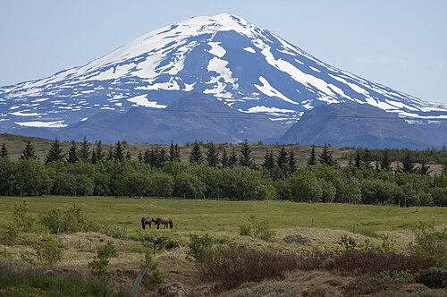
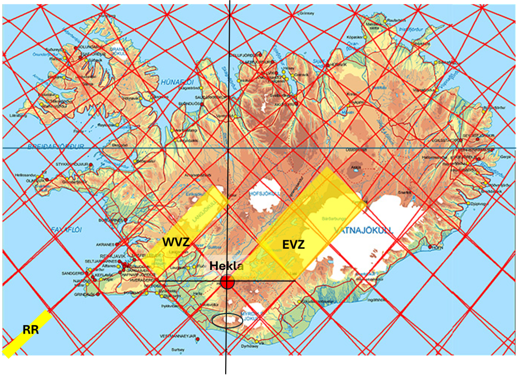
Hekla is known to occupy a uniquely important geological position within Iceland. It lies at the eastern end of the South Iceland Seismic Zone (SISZ) and simultaneously forms the southwestern gateway into the East Volcanic Zone (EVZ). In many ways, Hekla stands at the transition between two fundamentally different tectonic expressions: the transform-style seismic deformation of South Iceland and the broad volcanic rifting of the eastern volcanic systems.

The rifting process commonly described in Icelandic geology, where one side of Iceland drifts roughly 1 cm westward each year while the other moves about 1 cm eastward, can be visualized as being organized around a central tectonic division line that reaches the latitude and structural position of Hekla. This gives Hekla a particularly important geometric and tectonic role within the overall framework of Iceland.

The East Volcanic Zone is more difficult to represent with a single line than the oceanic ridges north and south of Iceland, because the EVZ is not a narrow ridge crest but rather a broad tectono-volcanic corridor 1.5° wide from east to west. In this interpretation, special emphasis is placed on the eastern boundary of the EVZ, which appears to function as a major division between tectonic domains associated with the North American and Eurasian plates. Rather than viewing the EVZ simply as a diffuse volcanic belt, it can therefore be examined as a structured rift system occupying a broad zone between deeper mantle flow divisions.

When zooming out to examine the large-scale geometry of Iceland itself, including the mid-ocean ridges and the surrounding continental shelf, an even more remarkable arrangement becomes visible, with Hekla occupying a central position within the overall symmetry.

Location of Hekla (red circle) and the Elliptical Outline of the Continental Shelf of Iceland.

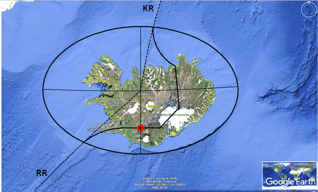
The continental shelf surrounding Iceland has a surprisingly regular form. The southeastern quarter of the shelf, in particular, remains relatively undisturbed and displays a sharp elliptical geometry that can be detected mathematically. The ellipse possesses clearly identifiable major and minor axes aligned directly east–west and north–south respectively. Significantly, Hekla is located on the north–south minor axis of this elliptical structure.

If the major and minor axes of the Icelandic shelf ellipse are drawn, and the oceanic segments of the Reykjanes Ridge and Kolbeinsey Ridge are extended toward Iceland from the south and north, the two ridge extensions converge precisely in the central point of the ellipse itself (extrapolation shown with dotted lines). This creates a striking geometric relationship between:

  • the elliptical form of the Icelandic continental shelf,
  • the mid-ocean ridge system north and south of Iceland,
  • the tectonic division between the North American and Eurasian plates,
  • and the position of Hekla within the overall structure.
https://images.openai.com/static-rsc-4/f0-26YLRxhCiJe-Z8uX1Q2B7ceulF2OD7H-1f2yVrPH5odNHbqA4tI9Z60AV0DdbyQbG7U0xvQZqy8F5o3SFFts3s8l2aDaW7zROriGXKW_8bQwV4MMAjj4BZzGOvQavqSl9XDhOBwfYs9x2TPJwF0-AMJY-NMqUhZ_rI9iOXk9R2U2qgLRgWCi-sHkWsqZT?purpose=fullsize

The tectonic division line through Iceland also appears remarkably symmetrical when compared with both the elliptical outline of the shelf and the extended ridge axes. North and south of Iceland alike, the plate division lines merge naturally into the mid-ocean ridges exactly where those ridges intersect the elliptical margins of the shelf.

Within this broader framework, the detailed geometry of mantle convection-roll polygons and their division lines becomes increasingly important. The interaction between different mantle layers, tectonic boundaries, volcanic zones, and continental-shelf geometry may together help explain why Hekla occupies such an exceptional position within Icelandic geology.

Location of Hekla.

Hekla has been regarded as Iceland’s most famous volcano for centuries, and perhaps not only because of its frequent eruptions and dramatic appearance. Its location suggests that it occupies one of the most structurally significant positions in the entire geological framework of Iceland.

Hekla
Uncategorized

The Three Corners of Vatnajökull

The largest glacier in Iceland, Vatnajökull, covers several major volcanic systems. Direct geological research beneath the glacier is difficult because of the extreme environmental conditions, thick ice cover, and active geothermal areas. Nevertheless, a remarkable amount is known about the volcanic framework beneath the ice.

Vatnajökull with Öræfajökull, Grímsvötn and Kverkfjöll.

Three prominent volcanic regions are especially important in this context because they appear to fit clearly into the proposed pattern of mantle convection roll division lines.

The first is Öræfajökull, the tallest volcano in Iceland, situated close to the 64th parallel. The second is Grímsvötn, a vast but more obscure volcanic and geothermal complex beneath central Vatnajökull. The third is Kverkfjöll, which occupies a relatively small polygon directly north of Öræfajökull.

Kverkfjöll is particularly significant because it marks the southern starting point of the North Volcanic Zone. From there, a remarkably direct volcanic axis can be traced northward all the way to Öxarfjörður, where the North Volcanic Zone meets the Tjörnes Fracture Zone. This fracture zone, in turn, connects the volcanic systems of Iceland with the offshore Kolbeinsey Ridge.

The geometrical relationship between these three volcanic centers is striking. The polygon formed by Öræfajökull, Grímsvötn, and Kverkfjöll appears exceptionally clear within the proposed convection-roll framework. In addition, Grímsvötn and Kverkfjöll are known to be petrologically related, suggesting a deeper structural connection beneath Vatnajökull.

Grímsvötn was also the source region of the magma and dyke propagation that eventually produced the catastrophic Laki eruption in 1783. Within this framework, the magma migration becomes especially interesting because the dyke propagated from one calculated division line toward another before the eruption began. Laki itself lies on one division line, whereas Grímsvötn occupies another.

The line extending from Kverkfjöll through Grímsvötn to Laki closely coincides with the eastern boundary of the East Volcanic Zone. The width of this volcanic zone can be measured directly on the surface, and it corresponds closely to the calculated width of the relevant convection roll in the model.

On the opposite side of the Grímsvötn–Kverkfjöll line lies Öræfajökull, which also marks the beginning of another volcanic alignment: the Öræfajökull Flank Zone. This zone trends northeast–southwest and extends toward Snæfell northeast of Vatnajökull. In total, the flank zone spans approximately the equivalent of two polygons within the proposed geometrical framework.

The repeated appearance of the same fundamental geometrical unit — polygons with an approximate east–west width of 1.5° — is one of the main reasons the model may provide a valuable tool for examining geological structures. According to this interpretation, the same geometrical relationships are not confined to Iceland alone, but may also appear in tectonic and volcanic systems throughout the world.

Geothermal areas of Iceland with superimposed mantle convection roll division lines and the tectonic boundary between the North American and Eurasian plates.

Within Iceland, however, Vatnajökull provides one of the clearest large-scale examples. Beneath the ice cap, some of the country’s most powerful volcanic systems appear organized in a pattern that mirrors the calculated geometry of the mantle convection roll model. Each polygon therefore becomes something like a chapter in a book, with each one containing its own distinct geological characteristics, tectonic structures, volcanic systems, geothermal activity, and landscape evolution.

Viewed in this way, Iceland can be examined as a sequence of interconnected geological “chapters,” where every polygon reveals a slightly different expression of the same underlying mantle convection roll system. One polygon may be dominated by rifting and fissure swarms, another by central volcanoes and geothermal fields, while a third may display transform faulting, glacial volcanoes, or complex magma interactions beneath ice caps.

This approach is valuable because it provides a structured way to examine geology step by step. Instead of viewing Icelandic geology as a collection of isolated volcanic systems, each region can be interpreted as part of a larger geometrical framework extending through the crust and into the mantle below.

The same method can also be applied to other parts of Iceland. The Reykjanes Peninsula, the South Iceland Seismic Zone, the Hengill area, the central highlands, and the northern volcanic systems all become individual “chapters” whose geological behaviour can be compared within the same overall framework.

In that sense, the polygon system is not only a geometrical model. It also becomes an organizational tool for understanding geology across many different scales — from magma migration beneath a glacier to the overall tectonic structure of Iceland itself.

Uncategorized

Iceland’s Seven Geothermal Power Stations

The seven geothermal power stations currently producing electricity in Iceland

Iceland is unique among nations because nearly all of its geothermal power production is located directly within an active plate boundary zone. The country stands astride the northern section of the Mid-Atlantic Ridge, where the North American Plate and Eurasian Plate slowly drift apart.

Within this environment, geothermal activity is not isolated. Instead, it forms part of a large interconnected tectonic and volcanic framework extending from the Reykjanes Ridge in the south to the volcanic systems of northeast Iceland.

The seven geothermal power stations producing electricity in Iceland are therefore much more than industrial facilities. Together they outline the geometry of the active volcanic belts of Iceland itself.


The Hengill Geothermal Complex

The largest concentration of geothermal power production in Iceland is found at Hengill, one of the most active volcanic systems in southwest Iceland.

Hellisheiði Power Station

Hellisheiði Power Plant

Located on the southern side of the Hengill volcanic system, Hellisheiði Power Station is the largest geothermal power station in Iceland. It produces both electricity and hot water for the Reykjavík metropolitan area. Steam rises from wells drilled deep into fractured volcanic rocks directly above the active rift zone.

However, it is noticeable that Hellisheiði Power Station is not situated exactly above the tectonic division line between the plates, but slightly offset along the mantle convection rolls division lines interpreted in the area. These red upwelling lines, associated with the second and fourth convective layers, being rather evenly distributed between approximately 120 and 670 km below Earth’s surface,  form the boundary between the Reykjanes Oblique Rift Zone and the West Volcanic Zone.

In this respect, the location of Hellisheiði resembles that of Svartsengi Power Station, as both are positioned along opposite sides of the same convection-roll framework.

Nesjavellir Geothermal Power Station

Situated near Þingvallavatn, Nesjavellir Geothermal Power Station occupies another section of the same tectonic environment. Together, Hellisheiði and Nesjavellir form the largest continuous geothermal utilization area in Europe. The two power stations largely make use of the same geothermal resources associated with the Hengill Volcanic System.

The location is highly significant geologically. The Hengill region lies exactly where volcanic activity, tectonic spreading, and large-scale fracture systems intersect.


Reykjanes Peninsula — Directly Above the Plate Boundary

The geothermal stations on the Reykjanes Peninsula are perhaps the clearest examples in the world of energy production directly tied to an exposed oceanic rift zone on land.

Svartsengi Power Station

Svartsengi Power Station became internationally known because of the nearby Blue Lagoon. However, geologically it is equally fascinating. The station extracts geothermal fluids from highly permeable volcanic formations created by repeated rifting episodes.

The intersections between the tectonic division line of Iceland and the interpreted convection-roll division lines are particularly apparent in this area.

Reykjanes Power Station

At the southwestern tip of Iceland, Reykjanes Power Station operates in one of the most tectonically active environments in the North Atlantic. Here, geothermal reservoirs are strongly influenced by seawater interaction and high-temperature magmatic systems beneath the peninsula.

The recent volcanic activity on Reykjanes has demonstrated how dynamic this part of Iceland remains.


Northeast Iceland — Rift Volcanism and High Heat Flow

The northeastern volcanic zone contains another cluster of geothermal power production associated with active crustal spreading.

Krafla Power Station

Krafla Power Station stands within one of Iceland’s most famous volcanic systems. The eruptions and rifting events of 1975–1984 transformed scientific understanding of how magma intrusions accompany plate spreading. A central hub, where several interpreted convection-roll division lines intersect within a comparatively small area, coincides with the geothermal activity associated with Krafla, Bjarnarflag Power Station, and Þeistareykir Power Station.

All of these three power stations are located slightly west of the tectonic division line, in apparent association with the mantle convection-roll division lines.

Bjarnarflag Power Station

Located near Mývatn, Bjarnarflag was one of Iceland’s earliest geothermal power stations. Though relatively small, it occupies an extremely important geological setting along the active rift.

Þeistareykir Power Station

Þeistareykir is one of Iceland’s newest geothermal developments. The area had long been known for extensive geothermal manifestations, but only in recent years has large-scale utilization become possible.


A Geological Pattern

What makes these seven power stations especially interesting is their apparent relationship both to the tectonic division line between the North American and Eurasian plates and to the interpreted divisions between the modeled mantle convection rolls mapped here. They are not randomly distributed across the country. Reykjanes Power Station and Svartsengi Power Station are found at the western end of the Reykjanes Peninsula, closely associated with the plate boundary zone itself.

In addition, Svartsengi appears to coincide with two downwelling lines associated with the second and fourth convective mantle layers. As mentioned before, these four modeled layers are interpreted as being rather evenly distributed between approximately 120 and 670 km below Earth’s surface.In many ways, the geothermal power stations themselves appear to reflect the tectonic framework of Iceland.

The pattern also illustrates a broader geological principle: geothermal energy is fundamentally linked to large-scale heat transport within Earth’s crust and upper mantle. Iceland simply exposes this relationship more clearly than almost anywhere else on Earth. For that reason, Iceland remains one of the world’s most remarkable natural laboratories for studying mantle processes, crustal spreading, volcanism, and geothermal systems.

Uncategorized

Six Geological Chapters Along Iceland’s Most Popular Tourist Route

The six “chapters” of the tourist route through South Iceland

For the first chapter marked on the map, you visit Þingvellir National Park. In order to get there, you pass through the highland structure of the West Volcanic Zone, and at its central axis you find the rift valley of Þingvellir. You then drive all the way to Laugarvatn, where abundant geothermal activity is found along the boundary of polygon 2. From there, you turn north until you reach the Geysir area and Gullfoss at the northern end.

If you wish to continue to other scenic areas in the south, you can follow the main road running parallel to the boundary between polygons 1 and 2 until you reach the Ring Road, where you make a 90° turn toward the southeast. The road remains fairly straight until it crosses the boundary between polygons 2 and 3. After that, it curves around the two glaciers Eyjafjallajökull and Mýrdalsjökull.

Polygon 3 is centered around Eyjafjallajökull and includes two famous waterfalls: Seljalandsfoss at its western end and Skógafoss on its southern slopes. After passing the town of Vík í Mýrdal, at the southernmost point of Iceland, you enter chapter 4.

There, you pass two enormous lava fields, the largest on Earth formed in recorded history, one from the Eldgjá eruption of 939 and the other from the Laki eruption of 1783. There are two parallel roads there, and you would probably choose the northern one (road No. 1), but I chose the southern one for illistration 🙂 At the boundary between polygons 4 and 5, another turn is made to the right, crossing that polygon and passing the glacial rivers flowing from Vatnajökull. This area is generally known as Skeiðarársandur.

Upon reaching the end of polygon 5, you drive around Öræfajökull, the largest volcano in Iceland. Entering polygon 6, you are on the road toward the Glacier Lagoon, Jökulsárlón. You can then continue along the road running parallel to the side of the polygon all the way to the eastern end.

If you notice other roads that fit this pattern in a similar way, convection rolls underneath affecting the road system, it would be very interesting to examine them as well.

Uncategorized

Understanding the Geothermal Areas in the North of Iceland

The geothermal activity of central North Iceland can be divided into three main sections: Skagafjörður, Eyjafjörður, and the Mývatn region. Skagafjörður was an active and distinct volcanic zone until a few hundred thousand years ago, after which the main rifting and volcanic activity gradually shifted eastward.

The distribution of geothermal activity in central parts of Norht Iceland

Eyjafjörður, however, remains an important area of geothermal utilization. Significant activity is found there, particularly in the Hjalteyri geothermal field, which produces around 110 liters per second of hot water. This accounts for roughly 60% of the heating supply for Akureyri, a town of about 20,000 inhabitants and often referred to as the capital of North Iceland. The use of geothermal energy here highlights how Iceland effectively harnesses subsurface heat for sustainable urban development.

Further east lies the Mývatn region, one of the most volcanically active areas in the country, centered around the Krafla volcanic system. This area has experienced numerous eruptions in historical times, including the well-known Krafla Fires in the 18th century and rifting episodes in the late 20th century. The region is characterized by high-temperature geothermal systems, extensive lava fields, pseudocraters, and active fissure swarms.

Geothermal and volcanic activity in this region continues northward beneath the surface, extending all the way to the ocean in Öxarfjörður. This follows the active plate boundary between the North American and Eurasian tectonic plates, part of the Mid-Atlantic Ridge system that crosses Iceland.

Knowing the location of convection rolls of different layers, the geothermal activity can be analyzed in more detail than previously possible. The impact of horizontal drift of the tectonic plates on one hand, and that of vertical effect of ascending magma on the other hand can be studied, and besides that local effect of horizontal flow of magma within particular convection rolls can be taken into account. Understanding those three main factors, geology becomes much more understandable.

The study area