Indonesia is one of the most remarkable geological regions on Earth. Thousands of islands stretch across the equator between Asia and Australia, while some of the world’s most powerful volcanic systems rise above active subduction zones. Yet the geological structure of Indonesia is not random. Certain large-scale patterns appear repeatedly, and some of them may reflect deep convection geometry within Earth itself.
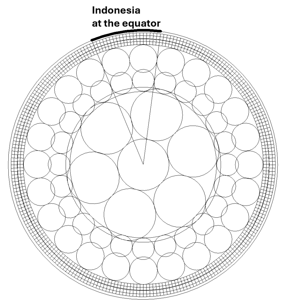
One of the clearest examples is found near the equator. The Indonesian subduction system contains major volcanic and tectonic segments spaced at surprisingly regular intervals. Particularly interesting are the great subduction arcs found 30° apart along the equatorial region. This large-scale spacing resembles geometrical organization rather than isolated local structures.
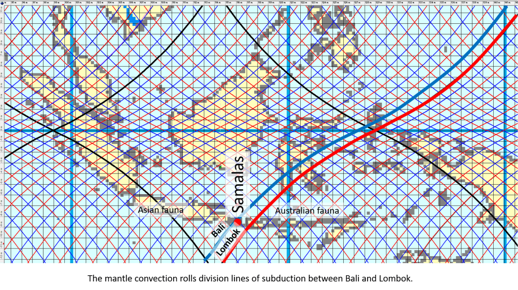
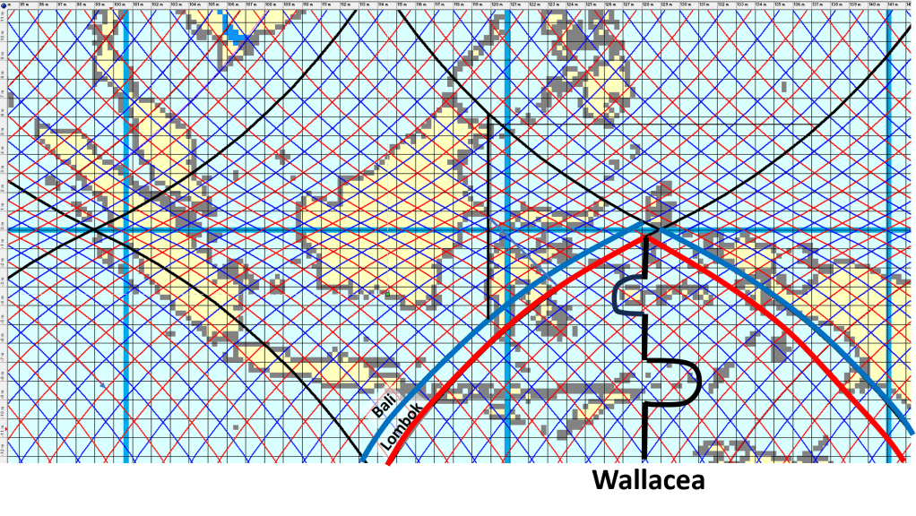
The deep channel between Bali and Lombok is not simply a surface feature. It coincides with a major tectonic and geological boundary zone. From the perspective of mantle convection geometry, this location represents a downwelling division line between adjacent convection rolls beneath the lithosphere.


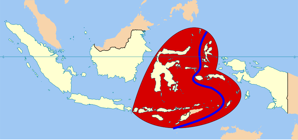
The Wallace Line
The naturalist Alfred Russel Wallace observed during the nineteenth century that an extraordinary biological boundary exists between Bali and Lombok.
West of the line, Asian flora and fauna dominate. Monkeys, woodpeckers, and many placental mammals are characteristic. East of the line, Australian affinities begin to appear. Cockatoos and other species linked to Australia become increasingly common farther east.
This boundary became known as the Wallace Line. What makes this especially remarkable is the geography itself. Bali and Lombok are very close together. At first sight one might expect that during Ice Age sea-level lowering the two islands would have been connected by dry land. But they never were, and the reason is that the strait between them is unusually deep. Even when sea level fell more than 100 meters during glacial periods, deep water remained between the islands. This preserved the biological separation over very long periods of time.
Deep Water and Downwelling
Division lines of the framework of the convection rolls model are of course both downwelling and upwelling. Sometimes the different effect of downwelling and upwelling becomes apparent, as downwelling zones may produce long-lived subsidence and deep marine corridors.
The Bali–Lombok Strait therefore becomes more than a biological curiosity. It may represent a surface expression of deep mantle organization.
The geometry is especially interesting because the downwelling line is parallel to a major lower-mantle upwelling division of the lower mantle (see cross section above). In this interpretation, the deep Earth structure controls not only volcanic belts, but also long-term oceanic depth patterns.
Geological Contrast Between Bali and Lombok
The difference between the two islands is therfore first and foremost to be traced to geophysics.


Mount Agung on Bali and Mount Rinjani on Lombok belong to the same general volcanic arc system, yet the geological environment changes noticeably eastward toward the Banda Arc transition.
Lombok also contains the remains of the gigantic 1257 eruption of Mount Samalas, one of the largest eruptions of the last two millennia.
Eastward from Lombok tectonic complexity increases, crustal deformation becomes stronger, and the Indonesian arc system begins bending toward the Banda Sea region.
Thus the Wallace Line coincides with biological change, bathymetric change, tectonic change, volcanic change, and of course mantle-flow geometry of the convection rolls model itself.
Inner Earth and Surface Evolution
The Bali–Lombok division demonstrates how deeply Earth’s internal structure may influence the surface environment. The persistent deep-water boundary prevented land bridges to form when water was trapped in large glaciers of the ice age and separated the ecosystems,
In this interpretation, the contrast between Asian and Australian realms did not arise merely from chance migration patterns or sea-level fluctuations. Instead, the geometry of mantle convection itself may have maintained the separation over geological time.
The result is one of the clearest examples on Earth where deep mantle structure, as derived from the convection rolls model, coincides with tectonics, in this case ocean depth, volcanism and biological evolution
It all appears to be interconnected within the same regional framework. https://en.wikipedia.org/wiki/Wallacea