Uncategorized

The Three Corners of Vatnajökull

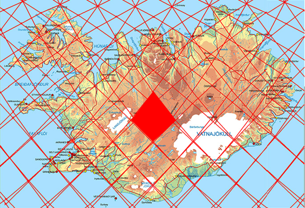
The largest glacier in Iceland, Vatnajökull, covers several major volcanic systems. Direct geological research beneath the glacier is difficult because of the extreme environmental conditions, thick ice cover, and active geothermal areas. Nevertheless, a remarkable amount is known about the volcanic framework beneath the ice.

Vatnajökull with Öræfajökull, Grímsvötn and Kverkfjöll.

Three prominent volcanic regions are especially important in this context because they appear to fit clearly into the proposed pattern of mantle convection roll division lines.

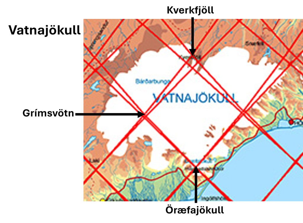
The first is Öræfajökull, the tallest volcano in Iceland, situated close to the 64th parallel. The second is Grímsvötn, a vast but more obscure volcanic and geothermal complex beneath central Vatnajökull. The third is Kverkfjöll, which occupies a relatively small polygon directly north of Öræfajökull.

Kverkfjöll is particularly significant because it marks the southern starting point of the North Volcanic Zone. From there, a remarkably direct volcanic axis can be traced northward all the way to Öxarfjörður, where the North Volcanic Zone meets the Tjörnes Fracture Zone. This fracture zone, in turn, connects the volcanic systems of Iceland with the offshore Kolbeinsey Ridge.

The geometrical relationship between these three volcanic centers is striking. The polygon formed by Öræfajökull, Grímsvötn, and Kverkfjöll appears exceptionally clear within the proposed convection-roll framework. In addition, Grímsvötn and Kverkfjöll are known to be petrologically related, suggesting a deeper structural connection beneath Vatnajökull.

Grímsvötn was also the source region of the magma and dyke propagation that eventually produced the catastrophic Laki eruption in 1783. Within this framework, the magma migration becomes especially interesting because the dyke propagated from one calculated division line toward another before the eruption began. Laki itself lies on one division line, whereas Grímsvötn occupies another.

The line extending from Kverkfjöll through Grímsvötn to Laki closely coincides with the eastern boundary of the East Volcanic Zone. The width of this volcanic zone can be measured directly on the surface, and it corresponds closely to the calculated width of the relevant convection roll in the model.

On the opposite side of the Grímsvötn–Kverkfjöll line lies Öræfajökull, which also marks the beginning of another volcanic alignment: the Öræfajökull Flank Zone. This zone trends northeast–southwest and extends toward Snæfell northeast of Vatnajökull. In total, the flank zone spans approximately the equivalent of two polygons within the proposed geometrical framework.

The repeated appearance of the same fundamental geometrical unit — polygons with an approximate east–west width of 1.5° — is one of the main reasons the model may provide a valuable tool for examining geological structures. According to this interpretation, the same geometrical relationships are not confined to Iceland alone, but may also appear in tectonic and volcanic systems throughout the world.

Geothermal areas of Iceland with superimposed mantle convection roll division lines and the tectonic boundary between the North American and Eurasian plates.

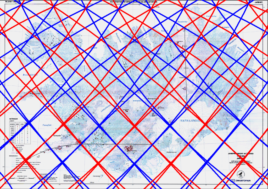
Within Iceland, however, Vatnajökull provides one of the clearest large-scale examples. Beneath the ice cap, some of the country’s most powerful volcanic systems appear organized in a pattern that mirrors the calculated geometry of the mantle convection roll model. Each polygon therefore becomes something like a chapter in a book, with each one containing its own distinct geological characteristics, tectonic structures, volcanic systems, geothermal activity, and landscape evolution.

Viewed in this way, Iceland can be examined as a sequence of interconnected geological “chapters,” where every polygon reveals a slightly different expression of the same underlying mantle convection roll system. One polygon may be dominated by rifting and fissure swarms, another by central volcanoes and geothermal fields, while a third may display transform faulting, glacial volcanoes, or complex magma interactions beneath ice caps.

This approach is valuable because it provides a structured way to examine geology step by step. Instead of viewing Icelandic geology as a collection of isolated volcanic systems, each region can be interpreted as part of a larger geometrical framework extending through the crust and into the mantle below.

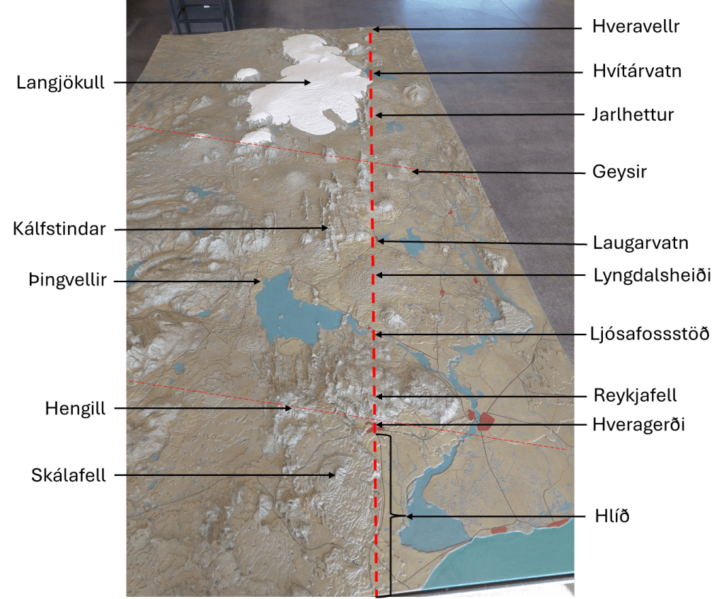
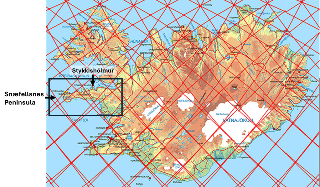
The same method can also be applied to other parts of Iceland. The Reykjanes Peninsula, the South Iceland Seismic Zone, the Hengill area, the central highlands, and the northern volcanic systems all become individual “chapters” whose geological behaviour can be compared within the same overall framework.

In that sense, the polygon system is not only a geometrical model. It also becomes an organizational tool for understanding geology across many different scales — from magma migration beneath a glacier to the overall tectonic structure of Iceland itself.

Uncategorized

The division line of the West Volcanic Zone of Iceland

By examining a relief map of Iceland, key geological features become far more apparent than they would otherwise. One such map is displayed in the lobby of the visitor center at Þingvellir.

The main division line of West Volcanic Zone and its surroundings

A broken red line has been drawn to delineate the boundary along the western margin of the Western Volcanic Zone. This boundary can be traced continuously from north to south across the landscape. At its northernmost extent lie Hveravellir, a significant high-temperature geothermal field situated in the central highlands. Immediately to the west is Langjökull, beneath which two volcanic systems are located. Proceeding southward, one encounters Hvítárvatn, a proglacial lake that serves as a major outlet for meltwater from Langjökull and lies directly on this geological boundary.

Further south, the Jarlhettur form a row of hyaloclastite ridges aligned along the same divisional trend. This boundary corresponds to the interface between two mantle convection rolls beneath the approximately 120 km thick lithospheric plate. In addition to this division, deeper convection rolls boundaries are present, above which lies the Geysir geothermal area.

South of this part, volcanic formations of a different character emerge, including Laugarvatnsfjall, located above the lake Laugarvatn, pointed out on the map. These formations extend westward to Kálfstindar at the side of the Þingvellir graben, which follows the same orientation as the main boundary shown here. The geothermal activity at Laugarvatn is well documented. Immediately south of Laugarvatn lies the shield volcano Lyngdalsheiði. The boundary intersects the summit crater Þrasaborgir.

Notably, the hydroelectric power stations along the Sog river are situated on this boundary, marking a transition from highland terrain to the west to lower elevations in the east. The former waterfall Ljósafoss was located precisely along this division. Further south lies the mountainous region associated with Hrómundartindur, of which Reykjafell, near Hveragerði, forms a part. Here, deeper boundaries between mantle convection rolls extend westward beneath the Hengill volcanic system. South of this area, sharply defined structural boundaries known as Hlíð appear. These correspond in practice to the eastern flank of the shield volcano Skálafell and associated volcanic formations along the eastern edge of the Western Volcanic Zone.

In this region, the mantle convection rolls rotate in opposite directions. The western side coincides with the West Volcanic Zone, where one convection roll resists the northwestward motion of the North American Plate. In contrast, the area to the east is transported along with the underlying mantle flow. Consequently, the western region is subjected to continuous extensional forces, resulting in crustal rifting. This process is most clearly expressed in the rift valley at Þingvellir.

Uncategorized

The Equatorial 30° Mapped Fact of the World

Explaining this is becoming easier with good drawings. AI got the idea! Please have a look at this map:

Try this yourself

Look at a world map and focus only on one line: the equator. Now follow it from west to east.

What do you see?

South America spans about 30° – The Atlantic Ocean spans about 60°. If you see that — keep going, and now continue along the equator:

  • West coast of Africa → Great Rift Valley 30°
  • Great Rift Valley → Mid-Indian Ocean Ridge 60°
  • Mid-Indian Ridge → West coast of Indonesia 30°
  • West coast → East coast of Indonesia 30°

Pause. Look again.

What pattern do you get?

30° – 60° – 30° – 60° – 30° One more step. Now try something else.

Start at the east coast of Indonesia
and trace the arc of the Ring of Fire
all the way to the west coast of South America.

So what do you find?

You have now followed the equator across the globe. The question is simple: Do you see a pattern — or not?Is it:more regular than expected, or less? Just look at the map. And decide for yourself. The more accurate maps you use the better. Then we are back to a more scientific approach:

Section of Mantle Convection Rolls System within the Earth

Along the equator, a pattern like this should be expected, because convection within the Earth does not occur randomly but tends to organize itself within each layer. The internal layers of the Earth have been measured with considerable accuracy, and it is well established that the temperature gradient of the mantle is close to adiabatic. This implies conditions similar to those found near the base of the tectonic plates, at depths of around 120 km, where mantle material is relatively stable, and below that it becomes capable of slow flow. Laboratory experiments show that under such conditions, mantle-like material tends to form convection rolls with approximately equal height and width. From this, it is reasonable to expect that a regular pattern of this kind should emerge within the Earth.

This expectation corresponds closely with the observed distribution of continents and mid-ocean ridges along the equator. The equator is a special case, because it represents a zone of symmetry in relation to Earth’s rotation. The horizontal component of the Coriolis effect is effectively zero there, while to the north and south it acts in opposite directions. As a result, the equatorial region provides particularly regular physical conditions, making it a natural place to look for large-scale structural patterns.

A familiar demonstration is often used to illustrate rotational effects: water draining in a sink tends to rotate in opposite directions in the two hemispheres. This is frequently shown near the equator as a simple experiment. But this leads to a more fundamental question: if rotation causes opposite behavior on either side of the equator, what happens exactly at the equator itself, where these effects balance out? Accordingly, we can find a reason why continents and ocean floor sections have a special distribution exactly along the equator! It is The Equatorial 30° Mapped Fact of the World!

Uncategorized

Snaefellsnes Peninsula – Iceland

The Snæfellsnes Peninsula is a particularly remarkable region of Iceland because it hosts three distinct volcanic systems aligned roughly east–west across the peninsula. Two of these systems have very similar names. The easternmost system is Ljósufjöll, and the central one is Lýsufjöll. Both names carry essentially the same meaning: “the light-coloured mountains.”

This name refers to the relatively silica-rich rock types found in these systems. Compared to many other volcanic areas in Iceland that are dominated by darker basaltic compositions, these systems contain a higher proportion of evolved, more silicate-rich rocks. The lighter coloration of the rhyolitic and dacitic components gives the mountain ranges their distinctive appearance and explains the origin of the names.

An additional noteworthy feature lies beneath the town of Stykkishólmur. The town receives geothermal hot water from a fracture zone whose orientation corresponds closely with predicted structural alignments derived from the convection rolls model of mantle flow. According to this interpretation, a deep-seated division line, representing a boundary between adjacent long convection rolls in the mantle, generated stress conditions favorable for fracture formation in the overlying crust. The present-day geothermal circulation would then be a surface expression of this deeper structural control.

At the same time, the surface morphology of the peninsula has been strongly modified by repeated glaciations. Glacial erosion has carved valleys and lineaments that follow a different dominant alignment. Interestingly, this second alignment also corresponds to another predicted set of division lines within the convection rolls model. In other words, both the geothermal fracture system and the glacially sculpted surface features appear to reflect deep structural patterns rooted in mantle convection dynamics.

Taken together, the volcanic distribution, geothermal fracture orientation, and glacial lineaments on the Snæfellsnes Peninsula may therefore represent multiple surface expressions of a deeper, organized mantle flow structure.

The town of Stykkishólmur:

Here it is on the map:

The town is heated with water from this fracture:

The surface is shaped according to another set of lines, also to be calculated:

On the westernmost tip of the Snæfellsnes Peninsula, Snæfellsjökull rises prominently above the surrounding landscape. This glacier-capped stratovolcano dominates the region both visually and geologically, forming a dramatic landmark at the edge of the Atlantic Ocean. Its symmetrical form and ice-covered summit make it one of Iceland’s most recognizable volcanoes.

Near its slopes once stood the home of Guðríður Þorbjarnardóttir, one of the most remarkable women of the Viking Age. Around the year 1000, she traveled with her husband to Vinland, where she lived for three years. During that time, she gave birth to her son, Snorri Þorfinnsson, who is considered the first European child born in the New World. Vinland is the old Icelandic name of the part of North America found south of Helluland (Baffinland) and Markland (Labrador), centuries before Columbus sailed over the Atlantic Ocean.

On the other side of the glacier, this painting shows Columbus in Iceland:

Behind them rises Snæfellsjökull, the glacier-capped volcano that inspired Journey to the Center of the Earth by Jules Verne. In Verne’s novel, the entrance to Earth’s interior is hidden within the crater of Snæfellsjökull, transforming this already dramatic volcano into a literary gateway to the planet’s deepest mysteries.

Uncategorized

The Mid-Iceland Belt

The Mid-Iceland Belt (MIB), also referred to as the Central Iceland Volcanic Zone, forms the volcanic connection between the West Volcanic Zone (WVZ) and the East Volcanic Zone (EVZ). Although the precise outlines of individual volcanic systems—particularly those associated with Hofsjökull and Kerlingarfjöll—vary somewhat between published maps, the overall geometry of the belt is consistent.

Within the Mantle Convection Rolls Model, the MIB occupies a central polygon bounded by division lines separating adjacent convection rolls. In addition, many tectonic maps depict a plate-boundary trace aligned approximately east–west through the MIB, reinforcing its interpretation as a zone of plate-scale interaction rather than a simple rift segment.

The Mid-Iceland Belt Polygon

Why the MIB differs fundamentally from WVZ and EVZ

The adjacent volcanic zones, WVZ and EVZ, can be interpreted as rifting zones located above convection rolls whose flow direction opposes the absolute motion of the overlying plate. In those zones, mantle flow and plate motion combine to promote sustained extension and focused rift volcanism.

The MIB does not fit this configuration. Located between the opposing roll-controlled rift systems, it occupies a region where this rifting mechanism does not apply directly. Its existence therefore cannot be explained as a primary spreading axis driven by roll-opposed plate motion. Instead, the MIB must be understood as a structural connection zone accommodating the transfer of deformation between the WVZ and EVZ.


Analogy with the South Iceland Seismic Zone

It has often been noted that the MIB performs a role analogous to that of the South Iceland Seismic Zone (SISZ). The SISZ is characterized by tectonically driven strike-slip and oblique faulting, accommodating lateral plate motion rather than sustained rift volcanism. The MIB is broadly parallel to the SISZ and occupies a comparable central position within its convection-roll polygon.

Between the polygons associated with the SISZ and the MIB lies an intermediate polygon, here referred to as the Hreppar Polygon (HP). Some interpretations treat the SISZ and HP—together with adjacent areas, often including the western margin identified as the Þingvellir rift—as a distinct tectonic microplate. In this framework, the northern boundary of that microplate coincides with the transition across the MIB.


Internal complexity of the MIB polygon

The MIB polygon itself displays a dual structural character. In its southern half, the bounding division lines of the convection rolls converge closely, producing a relatively unified structural pattern. Farther north, these division lines diverge, and an additional micro-polygon appears in the north corner. In this area, fissure swarms extending from the Hofsjökull central volcano exhibit an orientation that differs from that of the southern MIB, indicating localized reorganization of stress.


Comparison with the Tjörnes Fracture Zone

A useful comparison can be made with the Tjörnes Fracture Zone. Within the TFZ, the Húsavík–Flatey Fault accommodates almost exclusively horizontal dextral motion and has done so continuously for millions of years, producing a cumulative offset on the order of 60 km on each side. In contrast, the Grímsey Oblique Rift exhibits both seismic and volcanic activity. Although it is broadly parallel to the Húsavík Fault, it serves a different function: accommodating the combined tectonic and magmatic processes required to link the North Volcanic Zone with the Kolbeinsey Ridge.

In an analogous manner, the SISZ and the MIB together form a paired system: one zone primarily accommodating horizontal tectonic motion, the other incorporating significant volcanic processes.


Latitudinal variation in polygon patterns

The geometric arrangement of convection-roll polygons differs markedly between southern and northern Iceland. In the south, large and relatively regular polygons give rise to east–west-oriented structures, with one zone dominated by horizontal shear (the SISZ) and another incorporating volcanism (the MIB). In the north, the polygon pattern instead permits the development of a single, long-lived, continuous transform fault, represented by the Húsavík–Flatey Fault. Within the adjacent row of polygons, the Grímsey Oblique Rift fulfills the volcanic role associated with plate-boundary connection.


Closing synthesis

Taken together, these observations suggest that the Mid-Iceland Belt is neither a simple rift nor a conventional transform zone. Instead, it represents a mantle-controlled connection zone, complementary to the South Iceland Seismic Zone in the south. The pair of MIB and SISZ is analogous in function to the Grímsey Oblique Rift and Húsavík Fault in the north. The geometry of the MIB, internal complexity, and relationship to adjacent volcanic zones are best understood in terms of the spatial organization of mantle convection rolls rather than solely through plate-boundary kinematics.