Uncategorized

Partial Melting of Peridotite and the Subsequent Flow of Basalt Towards the Surface

It can be difficult to explain how peridotite undergoes partial melting to produce basalt, and how that basalt subsequently migrates upward through the lithosphere. Within the asthenosphere, there are no open voids or fractures through which melt can simply flow. Therefore, an important question is how the melt becomes concentrated and how it is transported upward through the ductile portion of the tectonic plate.

Partial melting of peridotite and the subsequent flow of basalt towards the surface

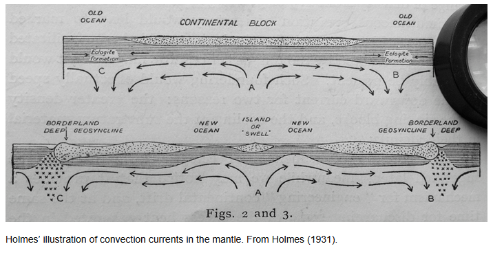
This schematic proposes that partial melting occurs in regions where pressure is reduced due to tectonic movements above. In addition, the interaction of adjacent convection rolls should combine their thermal influence with symmetric heat radiation, creating localized zones where conditions are favorable for partial melting.

The upward transport of melt through the ductile lithosphere must be assisted by some focusing mechanism, allowing it to move in narrow, directed pathways. Evidence for such pathways is found in the sheeted dike complexes within ophiolites, which could represent the uppermost expressions of these ascending melt channels.

One possible physical analogy is the Munroe effect, in which energy is focused into a narrow jet capable of penetrating solid material. In this context, a comparable mechanism might involve the concentration of thermal energy or stress along specific lines or zones, enabling sustained, directed upward flow through the ductile material. The symmetrical flow lines do then have to provide an appropriate “standoff”, a key concept regarding the physical preconditons of Munroe effect. Some might say that explosion on one hand and a steady process on the other hand are not comparable, but considering that the process is the same, even though one is short term, the other long term, the results will be similar.

Beneath oceanic plates, where the lithosphere is approximately 100 km thick, such focused flow could allow basaltic melt to traverse the ductile region. Upon reaching the brittle upper lithosphere, the melt would then exploit fractures and fissures, continuing its ascent.

Finally, as pressure decreases, volatiles exsolve from the magma, causing rapid expansion and increased buoyancy, which further drives the magma toward the surface or the seafloor.

Uncategorized

Examining how the Earth works

A Holistic Model of Energy Flow Within the Earth

The internal energy flow of the Earth can be approached through a set of simple but physically meaningful preconditions that together form a coherent conceptual model.

The first precondition is that radioactive decay supplies an energy output comparable to the total heat flux emitted by the Earth. This assumption is supported by geochemical evidence suggesting that the abundance of radioactive isotopes—particularly uranium-238, thorium-232, and potassium-40—in primitive meteorites is broadly consistent with the inferred composition of the Earth. If so, radioactive decay could account for the entirety, of Earth’s present-day heat loss.

The second precondition is that the mantle is partially transparent to thermal radiation, particularly the radiation produced by these radioactive elements, along with the outer core. Under this assumption, a portion of the radiative energy generated within the mantle can propagate downward and be absorbed by the inner core. In this framework, the inner core is not merely a passive reservoir of residual heat, but an active participant in a dynamic energy exchange system.

Energy received by the inner core is then redistributed through convection within the outer core, which acts as an efficient transport mechanism. This convective motion transfers heat upward toward the mantle across the core–mantle boundary (CMB), a region that plays a critical role in coupling deep Earth processes. From there, heat continues to move through the mantle by a combination of convection and radiation, ultimately reaching the base of the lithosphere.

Within the tectonic plates, heat is transported toward the surface through conduction and localized magma flow, giving rise to volcanic and tectonic activity. In this way, the model provides a continuous pathway for energy: from radioactive sources, through radiative transfer and convection, to surface expression.

A central point of debate concerns the radiative properties of the mantle. Conventional models often assume that the mantle is largely opaque to thermal radiation, which limits the role of radiative heat transfer. However, this assumption remains uncertain, particularly under the extreme temperatures and pressures of the deep mantle. If the mantle is more transparent than typically assumed, radiative energy transfer could play a significantly large role in Earth’s internal energy budget.

Another debated issue is whether the inner core is growing over time. Some models suggest gradual solidification of the core, while alternative perspectives argue that the core maintains relatively stable proportions and temperature through long-term dynamic equilibrium. If such stability holds, it would support a model in which energy input—potentially via radiative transfer—is balanced by outward heat flow.

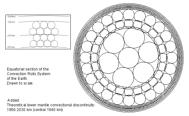
To explore the implications of this framework, convection rolls can be introduced into mantle layers as a simplified representation of large-scale flow. These structures provide a useful basis for comparison with observed surface patterns, such as tectonic plate boundaries, volcanic distributions, and heat flow variations. Preliminary comparisons, shown here, suggest that such models may reproduce certain large-scale features of the Earth’s surface, indicating that the approach is worthy of further investigation.

Basic convection rolls model, equatorial section

Conclusion

This holistic model proposes a testable alternative framework for understanding Earth’s internal energy flow. Its validity depends on key assumptions—such as the radiative transparency of the mantle and the long-term stability of the core—which can, in principle, be evaluated through observation, experiment, and modeling. The consistency between the mantle convection roll model and observed surface features has been rigorously tested here and shows strong agreement.

Uncategorized

Structural Parallels Between Eastern Indonesia and the East African Rift

A 90° Connection?

Introduction

At first glance, eastern Indonesia and the East African Rift appear to have little in common. One is dominated by deep ocean trenches and subduction zones, while the other is defined by continental rifting and volcanic valleys.

Yet when examined more closely, and positioned relative to specific longitudinal reference points, a striking structural similarity emerges.

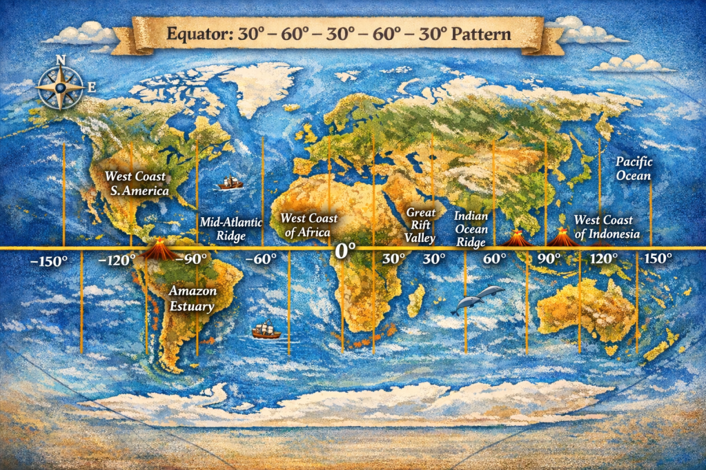
Similarities and coherence along equator
between Great Rift Valley and East Indonesia, with Amazon Estuary included.

Two locations, separated by exactly 90° in longitude (128.9°E in Indonesia and 38.9°E in East Africa), reveal comparable patterns of tectonic division. In both regions, deformation is not concentrated along a single boundary but instead distributed across multiple, parallel or opposing systems.

This raises an important question:
Are these similarities coincidental, or do they reflect deeper, global-scale organization within Earth’s mantle?


The Indonesian Reference Point: A Rare Double Subduction System

https://www.researchgate.net/publication/228495652/figure/fig1/AS%3A668987138535446%401536510371575/Detailed-tectonic-map-of-Molucca-Sea-area-displaying-geographic-features-described-in.png
The calculated convection rolls grid superimposed on a map
showing the Molucca Sea and the related subduction zones.

The point at 128.9°E lies just south of the Philippine Trench, within one of the most tectonically complex regions on Earth.

Immediately to the west lies the Molucca Sea region, characterized by a highly unusual configuration:

  • Two opposing subduction zones
  • Oceanic crust being consumed from both sides
  • Formation of colliding island arcs

This system is often described as a double subduction zone, where the Molucca Sea plate is being subducted both eastward and westward.

Key structural feature:

Deformation is split into multiple opposing boundaries rather than a single subduction interface


The African Reference Point: A Bifurcating Continental Rift

At 38.9°E, we encounter the East African Rift—a region where the African continent is actively splitting apart.

Unlike Indonesia, this is a divergent system, yet it shows a comparable structural division:

  • The rift splits into two distinct branches:
    • Eastern Rift
    • Western Rift
  • These branches run roughly parallel, enclosing a broad zone of deformation

Key structural feature:

Extension is distributed across multiple rift valleys instead of a single division.


Structural Similarity: Different Processes, Same Geometry

Despite their very different tectonic regimes, both regions share a common structural pattern:

FeatureEastern IndonesiaEast Africa
Tectonic regimeConvergent (subduction)Divergent (rifting)
StructureOpposing trenchesParallel rift branches
Deformation styleCompressionExtension
Common traitMulti-branch divisionMulti-branch division

Insight:

In both cases, the lithosphere does not deform along a single boundary.
Instead, it splits into multiple systems.


A Mantle Perspective: Distributed Deformation and Flow Organization

Both regions are located above areas of intense mantle activity:

  • Eastern Indonesia sits at the intersection of multiple major plates and microplates
  • East Africa overlies a mantle upwelling.

Within the framework of large-scale mantle convection:

  • Flow is not necessarily localized
  • Instead, it may organize into Reylaigh-Bénard type of convection rolls, very well known in physics.
  • These can produce zones of regular deformation at the surface

Hypothesis

Regions of strong mantle flow may not produce a single tectonic boundary, but instead generate paired or multiple systems, reflecting the motion in the overlying lithosphere.

In this view:

  • The double subduction in Indonesia (with two others just north and south of there)
  • And the dual rift system in Africa

…are different surface expressions of a similar underlying principle:
Deformation partitioning driven by large-scale mantle dynamics


Beyond Coincidence

The comparison between these two regions suggests that:

  • Complex tectonic features may follow recurring structural patterns
  • These patterns may not depend on whether the regime is compressional or extensional
  • Instead, they may reflect how mantle flow organizes lithospheric deformation

This aligns with a broader idea:

Earth’s surface tectonics, as in this case, may be better understood not as isolated plate boundaries, but as parts of a coherent, global system of mantle-driven structure

At approximately 51.1°W, 90° west of East Africa, lies the Amazon River estuary.

Unlike the other two regions, this is not an active plate boundary. It is part of a passive continental margin. However, it is far from simple.

Key characteristics include:

  • One of the largest sediment discharge systems on Earth
  • The Amazon deep-sea fan extending far into the Atlantic
  • A margin shaped by long-term interaction between:
    • Continental structure
    • Ocean basin evolution
    • Sediment loading and flexure

While not tectonically “active” in the same way, it represents a major function of mass redistribution and lithospheric response, and therefore its location can be connected with local lithospheric preconditions.


A Three-Point Pattern

We now have three locations:

  • 128.9°E → Eastern Indonesia (double subduction)
  • 38.9°E → East African Rift (dual rift)
  • 51.1°W → Amazon margin (major sedimentary system)

Each separated by roughly 90° in longitude.


Conclusion

The apparent symmetry between eastern Indonesia and the East African Rift—highlighted by their 90° longitudinal separation and shared multi-branch structure—invites a deeper, while the tectonic mechanisms differ, the structural resemblance is difficult to ignore. Adding the Amazon estuary, also with 90° longitudinal separation as compared with the East African Rift, this arrangement must be regarded as based on something else than coincidence. It should be kept in mind that all those locations are found exactly on the equator.

Rather than viewing these regions as unrelated anomalies, they may represent:

Different manifestations of a common, deep currents within Earth’s mantle


Uncategorized

The Icelandic Geological Discrepancy

Geodetic measurements show that plate separation across Iceland is directed approximately N15°E (equivalent to ~105° azimuth). This regional extension is commonly illustrated on geological maps by symmetrical vectors on either side of the island.

Yet the structural grain of the East Volcanic Zone at ~64°N trends N42°E, implying a misalignment of about 27° relative to the plate motion vector.

In classical fracture mechanics, extension should generate rifts perpendicular to the direction of maximum tensile stress. The observed geometry in Iceland therefore indicates that additional controls modify the stress field within the crust.

One plausible mechanism is the influence of organized **mantle convection patterns. If the upper mantle is structured into long, coherent convection rolls, their boundaries may impose a polygonal framework on the lithosphere. These boundaries can act as zones of mechanical weakness, guiding the localization and اتجاه of rifting.

In this framework, the regional plate-separation vector (N15°E) is not directly expressed at the surface. Instead, extension is effectively reprojected along the geometry of convection-driven domains, producing rift segments such as the East Volcanic Zone with an orientation of N42°E.

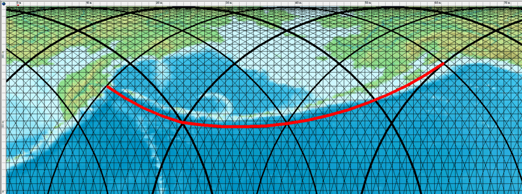
A map published by Iceland GeoSurvey, showing inferred convection-roll division lines, highlights this systematic angular discrepancy.

Map showing basic alignment of volcanic and seismic zones, along with the two vectors of plate separation.

Uncategorized

Lake Baikal Rift Zone

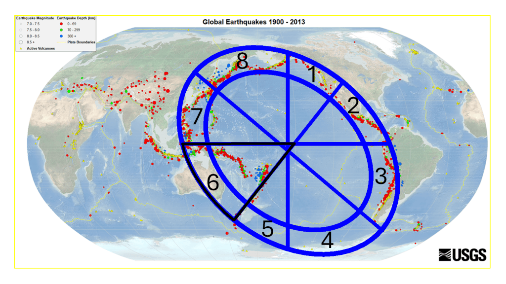
Examining Lake Baikal suggests that it can be interpreted as a surface expression of a deep-seated geodynamic process, potentially associated with a lower mantle convection roll extending 15° from east to west.

Map base from https://en.wikipedia.org/wiki/Baikal_Rift_Zone

The Baikal Rift Zone can then be subdivided into five distinct structural sections, as shown below:

  1. Western Segment – A deep, east–west–oriented basin forming the western extremity of both the lake and the rift system.
  2. Central Basin – The deepest portion of the lake, representing the core of rifting activity and maximum crustal thinning.
  3. Northeastern Segment – A structurally complex area aligned with the boundary between adjacent tectonic or mantle-flow domains (interpreted here as polygonal convection cells).
  4. En Echelon Rift Systems – A series of east–west–trending, staggered rift structures situated between boundaries of different lower mantle flow layers, suggesting segmented deformation linked to deeper dynamics.
  5. Eastern Termination – The distal end of the rift complex, where deformation becomes more distributed and transitions into surrounding tectonic regimes.

The principal rift axis appears to be located at the intersection of the central basin (2) and the northeastern segment (3), where structural and dynamic influences converge.

Lake Baikal is the deepest lake on Earth, reaching a depth of about 1,642 meters, and contains approximately 20% of the world’s unfrozen freshwater, making it one of the most significant hydrological reservoirs on the planet.

In this interpretation, the convection roll rotates counter to the direction of tectonic plate drift, helping to sustain and localize an extensive continental rift system. To show how the tectonic drift is opposed by the convection roll of lower mantle, this drawing below is added. It is not to scale, and the upper mantle convection rolls are omitted for clarity. But this is how it works.

  • The Baikal Rift Zone is often explained in conventional geology as a result of:
    • Far-field stresses from the collision of the Indian Plate with Eurasia
    • Lithospheric extension within the Eurasian Plate
  • Here, a deeper mechanism is added:
    • A large-scale lower mantle convection roll imposes stress on the tectonic plate.
    • Rotating opposite to plate motion, it thereby enhances extensional stress, stabilizing and sustaining the rift over long geological timescales.
  • The en echelon faulting often reflects oblique extension, which can result from interacting flow directions between mantle layers.