Uncategorized

Rethinking Earth’s Inner Engine: How Convection Rolls Shape the Planet

An Overview

What if Earth’s interior behaves like a system of long, swaying rolls — nested currents that move heat and mass in a planetary circulation? This post explains a holistic model where deep, large rolls in the lower mantle couple to finer rolls in the upper mantle, how heat can flow both ways, why basalt may originate beneath subducting plates, and how the planet’s rotation and curvature set the geometry of everything from mid-ocean ridges to the Ring of Fire.

The Earth as a Layered, Moving System

Most readers know the Earth as a set of layers: crust, upper and lower mantle, outer core, inner core. But these layers are not passive shells. They exchange heat, mass, and momentum through organized flow. The mantle convection rolls model treats the interior as a nested system of rolls — long coherent cells in the lower mantle and smaller, faster rolls in the upper mantle that directly interact with the crust.

Large rolls operate at depth, slowly moving material between the core–mantle boundary and the base of the upper mantle. Above them, upper-mantle rolls commonly span roughly 1.5° of latitude (a practical scale for near-surface circulation) and are more responsive to lithospheric structure and localized stress. Together they make up a continuous circulation that links the deepest parts of the planet to its outer skin.

Heat Can Be a Two-Way Street

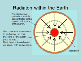
Classical descriptions emphasize heat escaping from the core toward the surface. The convection rolls model adds an important nuance: thermal radiation from radioactive elements found in upper layers heat the core. Rather than purely one-directional cooling, the interior operates with a dynamic thermal exchange — a feedback loop that helps sustain the system’s long-term behavior.

Where Basalt Really Comes From in Subduction Zones

The model revises the common view of arc magmatism. Instead of seeing basalt solely as a product of slab dehydration and consequent melting of the wedge above the slab, the convection rolls framework places the basalt source below the subducting plate. Deep upwelling associated with large rolls can rise beneath the slab and feed volcanism through both plates, making arc volcanism a surface expression of deeper roll-bound flows.

Rotation, Slab Dip, and Global Asymmetry

Earth’s rotation subtly modifies how descending slabs behave: westward-trending slabs are driven steeper into the mantle, while eastward-flowing slabs tend to be pulled out into shallower attitudes. This rotational influence produces systematic, global patterns in subduction geometry and has not been explicitly accounted for in simpler models of slab descent.

Ridges, Rolls, and a Global Geometric Pattern

Large mid-ocean ridges are not random. They align with the geometry of underlying rolls. Notably, the Reykjanes Ridge and Juan de Fuca Ridge follow the same formula and appear oriented 90° apart; by rotating one segment 90° they can be connected end-to-end to form a continuous upwelling track. The Mid-Indian Ridge also obeys the same relation. These systematic alignments support the idea that ridges are surface manifestations of deep convection boundaries.

The Curvature Problem — Why Rolls Sway and Why the Latitude of 32° Matters

One of the most important insights of the model is geometric: convection rolls “sway” because of Earth’s curvature. Imagine a roll whose overall horizontal flow is aligned perfectly north–south. On the spherical Earth, the east–west diameter of that roll (measured along a latitude circle) will vary with latitude. There exists a latitude where the east–west span of the roll equals the Earth’s radius when the roll is north–south aligned.

When you project latitude and longitude on a map with equal linear spacing (so that degrees of latitude and longitude represent equal lengths), a roll at that special latitude appears circular. Solving the geometric constraint for Earth gives the remarkable result that the latitude of exact north–south alignment is 32° N and 32° S. In other words, the roll geometry locks into a configuration at ±32° that allows a circular cross-section in that equal-length projection.

Why is this important? If the roll shapes are constrained by this curvature condition, then the entire system of rolls — their position and shape globally — can be derived from that constraint plus the roll spacing and boundary conditions. In practice this means there is a mathematical route to map every convection roll on Earth, leaving no gap in the global circulation. The calculation is nontrivial (a mathematical challenge involving spherical geometry and roll dynamics), but it yields a closed, self-consistent architecture: nested large rolls in the lower mantle and smaller 1.5° rolls in the upper mantle that tile the globe coherently. This solution was explored in the WGC 2020 paper and is a central pillar of the mantle convection rolls model.

A Planet-Wide Circulation System

One of the most intriguing implications of the convection rolls model is that it demonstrates how mantle material can circulate globally, not just vertically.

Because the rolls are continuous and curved along Earth’s spherical geometry, material can move both vertically and horizontally through the system. Starting from a point on the equator, an imaginary particle of mantle material could follow the flow paths around the planet and, after a full cycle, return to the same point.

This means that Earth’s interior is not a collection of isolated convection cells but a closed, interconnected circulation network. Over geological time, this circulation distributes heat and matter across the entire globe, linking distant regions in one coherent system.

Such continuous flow also provides a physical basis for the observed thermal balance of the planet. Global circulation allows heat to move in all directions — upward, downward, and sideways — maintaining a long-term equilibrium between core temperature and surface heat loss. In this way, the mantle convection rolls model not only explains motion but also the stability of Earth’s deep interior over billions of years.

The Gutenberg Layer: A Shared Zone Between Two Worlds

At the base of the mantle, around 2,900 km depth, lies the Gutenberg layer — traditionally described as the mantle-core boundary. Within the convection rolls model, this layer gains new significance.

Mathematically, it represents the intersection zone where the outermost part of the outer-core convection rolls meets the lowermost part of the lower-mantle rolls. Rather than being a simple boundary, it is a common zone shared by both systems — a transition and interaction region that couples two distinct convective domains.

This interpretation provides another alignment between mathematics and measurement: the calculated thickness of the intersection region in the model matches the observed thickness of the Gutenberg layer. It strengthens the plausibility of the model by showing how independent approaches — geometric derivation and seismic observation — converge on the same structural result.

The Gutenberg layer thus functions as a transfer zone, channeling heat and momentum from the core’s deep convection into the overlying mantle rolls. It marks the physical connection point in the great internal circulation engine, where deep energy exchange maintains the planet’s long-term thermal rhythm.

Also, how does deep, ductile mantle reach the surface through a brittle crust? Borrowing an idea from engineering — the Munroe effect (shaped-charge focusing) — the model argues that concentrated stress and heat can create focused upwellings or “jets” capable of piercing the crust. These focused pathways explain how mantle material can erupt or cool near the surface while the larger convection rolls remain intact.

The Ring of Fire as a Secondary, Mathematically Constrained Feature

From the roll geometry follow the major division lines between adjacent cells. Where several division branches intersect and curve around basins, an elliptical band of subduction and volcanism is produced — the Ring of Fire. In this model the Ring is not a single primary engine but a secondary feature dictated by the layout of roll boundaries. Key subduction loci (equatorial Indonesia, South America) and important continental tectonic centers (San Andreas, Yellowstone) fall out naturally from the geometry.

Toward a Unified, Testable Framework

Taken together, these ideas form a holistic portrait of Earth as a coherent, circulating system:

  • Nested rolls (deep and shallow) set global and regional patterns.
  • Heat flows both ways and can be focused into pathways that puncture the crust.
  • Basaltic sources beneath subducting plates and rotationally modulated slab dips follow from the same dynamics.
  • The spherical geometry of Earth forces roll shapes to sway and locks the system into a derivable global tessellation — with ± 32° as a key anchor.
  • Circulation through the entire planet maintains long-term thermal balance and explains the core-mantle coupling at the Gutenberg layer.

This framework is intentionally predictive: ridge alignments, slab dips, arc positions, and anomalous volcanic centers are all observable consequences. The mathematical derivation and case studies are discussed in more detail in the WGC 2020 paper and the Stanford 2023 presentation.

References & Further Reading

  • Comparing Large-Scale Geothermally Related Topographic and Bathymetric Features and the Mantle Convection Rolls Model, Stanford 2023.
  • A Comprehensive Model of Mantle Convection Rolls, Proceedings World Geothermal Congress, 2020.

Uncategorized

East–West Subduction Zone Asymmetry and the Role of Rotational Kinetic Energy

Observed Difference in Subduction Slopes

There is a clear and well-documented difference between the average dip of subduction zones that face east (about 27.1°) and those that face west (about 65.6°). This asymmetry has long intrigued geoscientists. Traditional explanations emphasize variations in the age and density of the subducting lithosphere—older seafloor is denser and therefore subducts at a steeper angle.

However, the Mantle Convection Rolls Model introduces an additional and complementary mechanism: the effect of Earth’s rotational velocity on the descending slab. Velocity of the subducting slab does not matter here, only the difference in rotational energy at different depths. We do not see how the tectonic plates move, but that does not mean we sould neglect the relevant calculations. In this case, calculating the difference is very simple.

Rotational Velocity and Kinetic Energy Loss

As the slab descends roughly 660 km—about one-tenth of Earth’s radius—it gradually loses rotational velocity, as the circle at surface is obviously longer then the lower circle. It therefore involves a significant kinetic-energy transfer to the surrounding mantle. If we set Earth’s radius as 1, the radius at 670 km depth is ≈ 0.9. At the equator, the difference in kinetic energy between these levels can be estimated as rotational energy at surface subtracted by rotationa energy at 670 km depth:

The result, 0.2, means that about 20% of the slab’s kinetic energy is dissipated while moving from the surface to the transition zone. Considering that the tangential velocity at the equator reaches about 1 ,674 km h⁻¹, a 20% reduction represents an immense energy transfer to the surrounding material. Imagine what happens to one cubic kilometer of slab after it loses 20% of its kinetic energy with the velocity of 1 ,674 km h⁻¹. Should it have no effect at all, or should it alter the dip of the descending slab? Of course the dip is affected by this transfer of energy, and it fits very well to the difference between the east and west of the Pacific Ocean.

The aggregate effect of this energy loss manifests differently on opposite sides of the Pacific. Along the eastern margins, the energy dissipation induces compressional pressure between converging plates; along the western margins, it produces a tensional or pulling effect. These opposing mechanical environments contribute to the observed difference in average slab dip: approximately 46° overall, with west-oriented subduction averaging near 65° and east-oriented near 27° (described in an essay by Doglioni & Panza, 2015).

Geometric Representation

This relationship can be illustrated geometrically. If the rotational velocity at Earth’s surface is represented as u = 1 and at 660 km depth as u = 0.9, two similar triangles can be drawn to represent eastward and westward subduction. The short side of each triangle—the horizontal gap between real flow (red) and the hypothetical no-rotation line (black)—corresponds to the observed angular difference. These geometric relations visually express how differential rotational velocity produces the characteristic east–west asymmetry of slab inclination. The simple drawing below shows the average difference.

Equatorial Symmetry and Mantle Roll Alignment

The same principle extends horizontally. The main division points of the equator coincide strikingly with the division boundaries of modelled lower-mantle convection rolls, which are spaced 30° apart. When subduction zones located exactly 180° apart on the equator are compared—most notably those of South America and Indonesia—their symmetry becomes evident. The position of these two trenches opposite each other can by no means be said to be just a coincidence.

S-America and Indonesia Convection Model

This has of course been mapped in detail for each subduction zone. In turn, those subduction zones show identical, although mirrored, deviation from true north. This symmetry can be explained by referring to the mantle convection rolls model. The fact that not only position, but also deviation from north is identical can not be said to be just a coincidence.

Integration Within the Mantle Convection Rolls Model

According to the Mantle Convection Rolls Model, the slab ultimately enters a ductile, convecting mantle where geophysical conditions are balanced. The difference in slab dip between east- and west-oriented subduction zones thus arises from the rotational-kinetic interaction between the descending plate and the mantle framework through which it moves.

Horizontally moving mantle material is similarly governed by the rotating geoid, producing predictable deviations from straight-line flow that define the roll-like geometry of convection cells. The vertical and horizontal components of this system are dynamically linked—both shaped by the same rotational gradients that influence slab inclination.The Missing Correlation Between Seafloor Age and Slab Dip

If slab dip were controlled primarily by the age of the subducting seafloor, one would expect a clear correlation between older, denser lithosphere and steeper subduction angles. However, such a relationship is not observed—particularly along the western margin of the Pacific Ocean.

For example:

  • The Mariana Trench, one of the deepest and steepest subduction zones on Earth, indeed involves an old oceanic plate (>150 million years). But if seafloor age were the decisive factor, then all regions subducting comparably old crust should exhibit similar dip angles—which they do not.
  • Along the Japan Trench, the subducting Pacific Plate is also very old (130–140 million years), yet its dip is far shallower in many segments, especially near Honshu and Hokkaido, where the slab inclination decreases dramatically toward the northeast.
  • Conversely, some younger lithosphere—such as that near Tonga or New Britain—subducts at extremely steep angles, contradicting any simple “old plate = steep dip” rule.

In other words, no systematic correlation exists between the age of the descending seafloor and the dip angle of subduction along the western Pacific. This observation directly contradicts the density-driven model, while strongly supporting a dynamic explanation based on Earth’s rotational velocity gradients.

The striking and consistent difference between eastward- and westward-dipping slabs, on the other hand, reveals a clear global pattern that matches the expected distribution of kinetic energy within the rotating mantle.

Why Has This Explanation Been Overlooked?

It may appear surprising that such an evident physical relation—between Earth’s rotation and slab dip—has not been explicitly emphasized before. The reason may lie in the timescales involved.

When a unit volume of lithosphere, say one cubic kilometer of slab, moves downward by 100 km, it inevitably tends to drift eastward relative to the overlying surface because its rotational velocity decreases with depth. The motion is fully deterministic: the deeper the material sinks, the greater its lag relative to the surrounding mantle at that depth.

Yet this motion unfolds extremely slowly—so slowly that, within the human timeframe or even during the lifespan of an oceanic plate, the effect seems negligible. Over millions of years, however, this cumulative eastward drift becomes geophysically significant.

It alters the balance between horizontal traction and vertical descent, subtly controlling slab geometry.
Because geoscientific models typically focus on instantaneous plate velocities rather than rotational energy differentials, the long-term kinematic consequences of Earth’s rotation have been largely overlooked or treated as negligible.

Thus, the explanation first formulated here appears novel not because it contradicts known physics—but because it applies fundamental physical reasoning (rotational mechanics) across a geological timescale that previous models rarely considered in full.

Conclusion

The consistent difference in dip angle between east- and west-oriented subduction zones can therefore be interpreted as a manifestation of Earth’s rotational dynamics coupled with the internal organization of mantle convection rolls. This integrated view connects global rotation, energy dissipation, and large-scale convection geometry into one coherent framework, offering an explanation that aligns observed slab asymmetry with measurable physical principles.

The geometry of subduction zones—both in terms of dip angle and global distribution—reflects the interaction between Earth’s rotation, kinetic energy dissipation, and large-scale mantle convection rolls.The absence of any correlation between seafloor age and slab dip across the western Pacific undermines the traditional density-based explanation. Instead, the consistent and global asymmetry between eastward and westward subduction aligns naturally with the physics of a rotating planet, where angular momentum and kinetic energy vary systematically with depth and latitude.What may initially appear as asymmetric behavior of tectonic plates can thus be understood as a predictable consequence of rotational mechanics acting within a viscous, convecting mantle—an effect long hidden simply because of its subtlety and timescale.

Uncategorized

The Logic of 30° Intervals Along the Equator

When we look at Earth’s surface, it’s easy to get lost in the details of coastlines, mountain ranges, rivers, and ridges. But if we step back and think about the planet’s deeper structure, something fascinating emerges: a repeating pattern along the Equator that follows 30° intervals.Why does this matter? Because these intervals may reflect the way Earth’s mantle moves beneath our feet.30°: A Hidden Rhythm of the Earth

Here’s the basic observation: the distance from a continental coastline to the nearest mid-ocean ridge along the Equator is 30° in a repetitive way. That number also shows up inside Earth, as the depth from the upper mantle down to the boundary above the outer core (the Gutenberg discontinuity) corresponds to the same span if you measure it along the Equator.

In other words, Earth seems to “prefer” structures that fit into neat 30° chunks, both at the surface and deep inside.

This suggests that mantle convection rolls, the giant slow-moving currents that circulate heat within the Earth, might be about as tall as they are wide, filling out the relevant space like building blocks.

Do These Rolls Really Exist?

We can’t measure mantle convection rolls directly, only thickness of Earth’s layers. But if the theory holds, then we should see their influence on the surface. One way to test this idea is to trace the Equator step by step and look at how major features line up.

Step by Step Along the Equator

If we follow the Equator around the globe, we can divide it into roughly 30° segments. Each of these intervals is marked by a major geologic boundary — a coastline, ridge, or rift. Here’s how it looks:

  • East Pacific Rise → West Coast of South America
    The East Pacific Rise is one of the fastest-spreading mid-ocean ridges on Earth. About 30° west lies the subduction zone of the Andes, where the ocean floor sinks beneath the continent, fueling earthquakes and volcanoes.
  • West Coast of South America → East Coast of South America
    Crossing the continent, we move from the dramatic tectonic activity of the Pacific margin to the quieter Atlantic side. This stretch includes the Amazon Basin, with its massive river system, which itself aligns closely with the 30° spacing.
  • East Coast of South America → Mid-Atlantic Ridge
    The Atlantic Ocean opens here, with the Mid-Atlantic Ridge running down its center. This ridge is part of the global rift system, where magma rises to form new ocean floor.
  • Mid-Atlantic Ridge → East Coast of Africa
    Another 30° step brings us to the African coastline, which mirrors South America’s. This pairing reflects the ancient breakup of Gondwana, a perfect example of how mantle flow leaves a lasting imprint on surface geography.
  • East Coast of Africa → Great Rift Valley
    The East African margin lies above mantle upwellings. Just 30° inland, the Great Rift Valley splits the continent, an active rift zone where the crust is being pulled apart and new oceans may someday form.
  • Great Rift Valley → Mid-Indian Ridge
    Continuing eastward, the Equator crosses the Indian Ocean, where the Mid-Indian Ridge rises. Like other spreading centers, it’s a direct expression of convection currents pushing Earth’s plates apart.
  • Mid-Indian Ridge → East Coast of Indonesia
    Here the Equator traverses a broad ocean basin before reaching Indonesia. This region sits at the collision of several tectonic plates, where subduction and volcanism dominate.
  • East Coast of Indonesia → West Coast of Indonesia
    Within just 30°, we pass across one of the most tectonically active areas in the world. Subduction zones border both sides of Indonesia, creating a chain of volcanoes and frequent earthquakes.

The Pacific Exception

One striking difference emerges in the Pacific Ocean. Unlike the Atlantic or Indian Oceans, the Pacific has no continental landmass near its center. Hawaii, located north of the Equator, lies above a lower mantle division line according to the comprehensive convection rolls model, but not on the Equator itself.

This means the Pacific spans a much wider interval: about 150° from Indonesia to South America, or 120° from Indonesia to the East Pacific Rise. At the Equator, the East Coast of Indonesia and the West Coast of South America mark the outer edges of the Ring of Fire. From those two points, subduction zones stretch in a regular arc all around the Pacific Basin.

In this sense, the Pacific doesn’t break the pattern, it expands it. The Equator provides the framework for tracing the boundaries, while the Pacific demonstrates how convection rolls and plate boundaries can extend into even larger structures.

Coincidence… or Deep Structure?

Is this just chance? Statistically, it seems unlikely that so many major boundaries would fall into such regular intervals. If we consider tectonic drift, the slow movement of continents and oceans over millions of years, the fact that we see such symmetry today is even more striking.

But once we think about the mantle’s convection rolls, the puzzle pieces start to fit. The surface divisions may simply be echoes of these massive, deep-seated currents.

Beauty in Regularity

Some of Earth’s most famous features fall right on these boundaries:

  • The Great Rift Valley in East Africa.
  • The Amazon River estuary in South America.
  • Subduction zones along the Andes Mountains.
  • The converging coasts and volcanic arcs of Indonesia.
  • And the sweeping Ring of Fire, stretching from South America to Indonesia.

Even the north-south symmetry of the Atlantic Ocean fits into the pattern. When you look at a world map with this in mind, it’s hard not to see a hidden order, a kind of natural geometry that shapes both land and sea.

Why It Matters

This isn’t just an exercise in pattern-spotting. If convection rolls in the mantle really do leave their fingerprint on the surface at 30° intervals, then studying these divisions could help us understand Earth’s inner workings more deeply.

It’s a reminder that the beauty of our planet isn’t only in mountains and oceans, but also in the invisible rhythms of the deep Earth that quietly shape them.

The Equator and the pattern of 30° intervals leading to the surface.
Uncategorized

How Heat is Conveyed within the Earth

The transfer of heat from Earth’s core to its surface is one of the fundamental processes driving our planet’s dynamics. The temperature difference is immense: the inner core is estimated to be hotter than the surface of the Sun, while the overlying mantle is several thousand degrees cooler. This gradient is sustained because radioactive heat sources are distributed unevenly within Earth’s interior.

Radioactive elements such as uranium, thorium, and potassium are concentrated mainly in the crust and upper mantle. They are chemically incompatible with the iron–nickel alloy that makes up the core and therefore absent from the deep metallic layers. As a result, the core itself does not produce radiogenic heat.

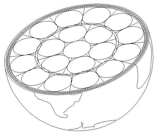
Surrounding the inner core, the outer core is a liquid metal where there is quite obviously space for six different convection cells, shown in countless drawings found in geophysical literature. At the boundary between the outer core and the mantle, the Gutenberg discontinuity, heat is transferred into the lowermost mantle.

The mantle is said to be plastic, because it is balancing between solid and liquid state. On geological timescales it behaves as a very slow, viscous fluid. This allows it to circulate, with hot material rising and cooler material sinking in enormous mantle convection rolls. Such convection provides an efficient mechanism for transferring heat from the deep Earth toward the lithosphere. When this heat reaches the lithosphere, the situation changes. The lithosphere, comprising the tectonic plates, is rigid and brittle. Here, heat can no longer be transferred effectively by convection; instead, it passes upward by thermal conduction, producing the steep geothermal gradient observed in the upper crust.

At certain boundaries, such as mid-ocean ridges, rift zones, and volcanic hotspots, mantle convection currents concentrate and channel heat more directly to the surface. Where two convection rolls meet, the focused upwelling of heat and pressure can act in a way somewhat comparable to the Munroe effect known from the physics of shaped charges: energy becomes concentrated along a narrow path, enabling molten rock to rise through the crust. This focused delivery of heat and magma helps explain the occurrence of volcanism at structurally weak points in the lithosphere.


Heat Radiation and the Core’s High Temperature

An additional factor that deserves close attention is the role of thermal radiation from radioactive elements in the upper mantle and crust. While radiogenic isotopes are unevenly distributed, their heat production is substantial, and the resulting radiation does not remain confined to local surroundings. Laboratory studies have shown that the thermal conductivity of mantle materials increases strongly at high temperatures. This implies that radiative transfer of heat through the mantle becomes increasingly significant under deep-Earth conditions.

From this standpoint, it is logical to consider that heat radiation generated in the upper mantle and crust can reach all the way down to the inner core. This view challenges the traditional assumption that the mantle acts only as an insulating blanket that slows cooling of the core. Instead, the mantle may also act as a medium that allows long-range transfer of radiative energy into the deepest interior.

This has important consequences for how we interpret the origin of Earth’s core heat. Physicists such as Max Planck calculated that if Earth’s interior relied solely on primordial heat left over from accretion, that heat should have dissipated very quickly relative to Earth’s 4.5-billion-year age. By this reasoning, the amount of primordial heat still retained in the core today must be negligible. Similarly, if downward heat radiation from the mantle is sufficient to maintain the core at high temperatures, then the release of latent heat from inner core crystallization also becomes only a minor contribution.

The conventional models that invoke secular cooling and crystallization as the dominant heat sources are understandable, given the historical focus on conduction and convection. However, they do not fully account for the efficiency of radiative transfer in high-temperature mantle materials. My analysis therefore leads to the conclusion that the extraordinarily high temperature of the core can be explained almost entirely by heat radiation from radioactive elements in the upper layers of the Earth. Rather than being a passive reservoir of slowly fading primordial heat, the core is actively sustained by radiative energy generated above it.


Convection and Radiative Balance

This interpretation also reframes how we understand convection within Earth’s main layers. The mantle, outer core, and even the inner core’s boundary layers all fit the geometric conditions for Rayleigh–Bénard type convection to occur: a fluid or semi-fluid medium heated from below (or internally) and cooled from above. For such convection to remain stable over geological timescales, the rate of convective circulation must stay perfectly balanced with the intensity of heat radiation reaching the inner core.

In other words, the deep Earth operates as a finely tuned thermal engine. Radiative input from above sustains the temperature of the core, while convection in the mantle and core ensures the continuous upward transport of heat. This delicate balance drives plate tectonics, fuels volcanic activity, and maintains the dynamic processes that have shaped Earth for billions of years.

The Convection Rolls System.

Uncategorized

Circular aspects of the Ring of Fire

Describing The Ring of Fire according to the map below, the San Andreas Fault and Yellowstone play the main roles. Accordingly, The Ring of Fire covers a rather wide area, mathematically confined. The San Andreas Fault has a section moving continually, as no pressure accumulates due to the fact that the drift direction of the Pacific Ocean Tectonic Plate is exactly parallel to the fault alignment. Just to add one fact, the sliding effect is due to the fact that the Pacific Plate drifts slightly away from the North American Plate at that point, but the North American Plate moves towards the point, so the combined result is a smooth, perpendicular meeting point. This is the most important thing to understand in an attempt to understand the preconditions of the Ring of Fire.

Yellowstone is therefore also a key point of the Ring of Fire. For a manifistation of that statement, we should have a look at a basic geological map of the Yellowstone Caldera:

Calderas tend to be regular, and therefore an elliptical form is used to aproximate the outlines of Yellowstone. Then the major and minor axis of the ellipse become apparent, and they are perpendicular and parallel, respectively, to the edge of the Ring of Fire at that location. The minor is aligned in the same way as San Andreas Fault. It is not necessary to add a detailed map of San Andreas Fault complex here, because everyone knows that it is logically parallel to the Ring of Fire.

Taking this a bit further, the Pacific Tectonic Plate drifts as a whole in one direction. On the contrary, the adjacent plates of America and Eurasia rotate towards the Pacific. The Ring of Fire also includes other plates than the Pacific Ocean Tectonic Plate, as it is defined. Other factors determine its scope too, and there we have the pattern shaped by convection rolls. The different layers of rolls have intersection points, coinciding with the outer and inner edges of the Ring of Fire. That provides the mathematical base for the elliptical form of the Ring of Fire. The way to realize this is simply to trace the two concentric yellow ellipses marking the Ring of Fire, and see how many intersection points each of them coincide with. The width of the Ring of Fire therefore always remains mathematically the same in proportion with the grid formed by latitudes and longitudes.

This description of the Ring of Fire is presently of a secondary nature, because first you have to have knowledge about the Mantle Convection Rolls Model, and then about the Ring and Fire and how it is related to the said model. Besides that, the tectonic drift vectors are not always presented as on the map above. A solid reference frame, and a view from space with GPS should describe tectonic drift in the best way. And it should be noticed that Yellowstone, according to this analysis, is a part of the Ring of Fire. More about this in my paper: https://pangea.stanford.edu/ERE/db/GeoConf/papers/SGW/2024/Thorbjarnarson.pdf