Here, a geometrically constrained, physics-motivated model for the large-scale convection architecture of Earth’s interior, is developed. The central objective is to show that the apparent complexity of surface geology can be understood as the surface expression of a comparatively regular interior system—one that is (i) consistent with the known physical behavior of convective flow and (ii) strictly constrained by geophysical measurements of Earth’s layered structure.
The method is intentionally bottom-up. It begins with measured layer thicknesses and a small number of physical principles, imposes a strict geometric requirement on how convection must occupy those layers, derives a three-dimensional convection-cell architecture, and only then (in Part II) compares the resulting predictions with surface observations such as fault systems, mid-ocean ridges, volcanic zones, and geothermal provinces. Iceland serves as a particularly powerful natural laboratory because multiple parts of the system intersect there.
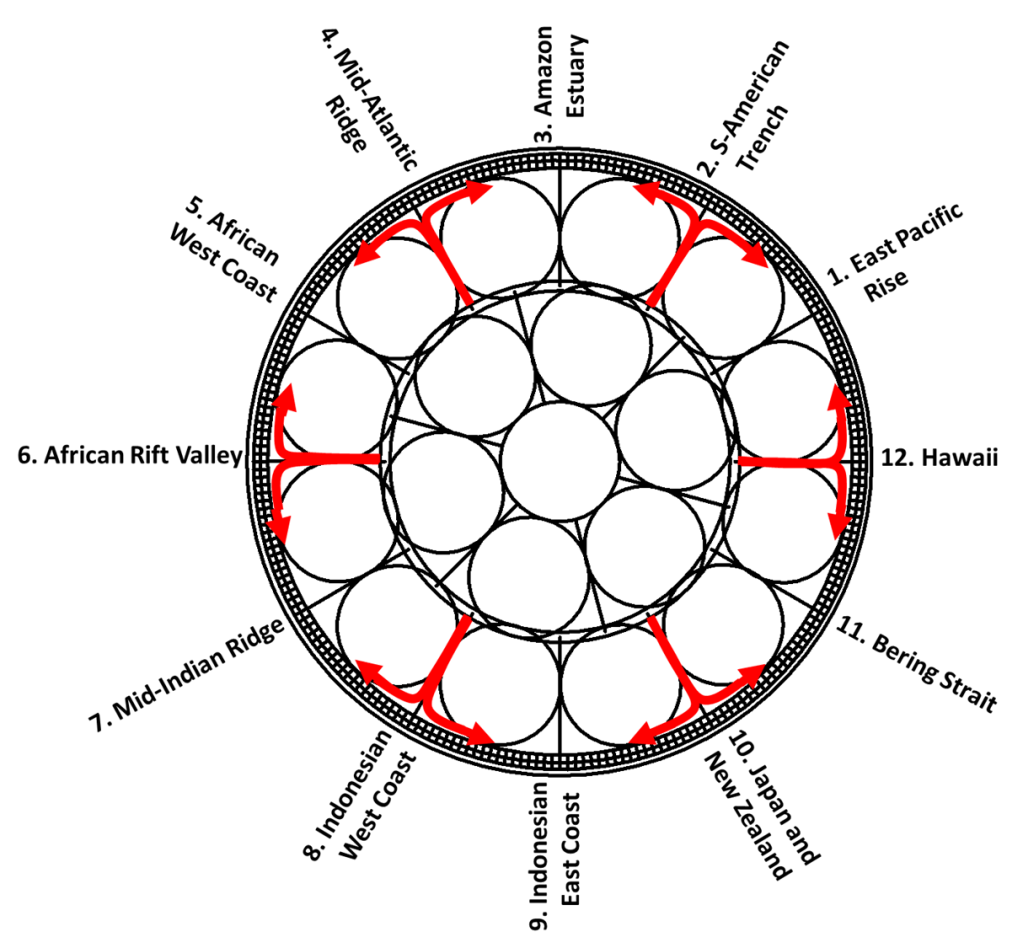
The 12 main division lines of the lower mantle convection rolls system.
A chain of implications:
Layering → Geometry Earth’s measured internal stratification defines fixed radial spaces that convection must occupy.
Physics → Cell proportions Rayleigh–Bénard convection under balanced conditions favors rolls with comparable vertical and horizontal dimensions.
Exact filling → Discrete structure When layers are required to be filled exactly by RB roll sections, characteristic cell sizes and integer counts emerge.
Rotation → Curvature Earth’s rotation constrains the horizontal planform of flow, producing systematic curvature and latitudinal organization.
Continuity → Intersection zones Global circulation requires geometrically defined zones where different roll families and layers connect smoothly.
Petrology → Two-layer interpretation The resulting upper-mantle structure naturally accommodates two chemically distinct source regions, consistent with MORB and OIB.
Heat transport → Focused pathways Convection, conduction, radiation, and focused melt transport together explain how a regular interior system can produce localized surface volcanism.
The guiding premise throughout Part I is that regularity is the default expectation for a slowly evolving, rotating convective system operating over geological timescales inside a nearly spherical body.
Background
When Earth’s internal layers—defined seismologically—are drawn to scale, their thicknesses exhibit a degree of regularity that invites geometric testing. The working hypothesis is that this regularity is not accidental: convection within the Earth organizes itself in a way that fills the available radial space efficiently and repeatedly.
The model does not introduce new physics. Instead, it organizes existing measurements within a coherent geometric and physical framework, extending classical ideas about mantle convection and plate motion in the conceptual tradition of Sir Arthur Holmes and Harry Hess, besides Alfred Wegener and others. The novelty lies in enforcing internal consistency across all layers simultaneously.
The governing preconditions are deliberately minimal:
Thermal forcing: sustained heat flow requiring convection in the mantle and outer core.
Rotation: Earth’s spin, introducing Coriolis constraints on horizontal flow.
Measured stratification: seismically determined depths of major boundaries and transition zones.
If convection has operated for billions of years in a thick, relatively homogeneous mantle, logic suggests that the system approaches a balanced, quasi-steady organization. Under such conditions, repetitive structures are expected rather than arbitrary ones.
Radial geometry and the primary constraint
The central requirement of the model is simple and strict:
Each convecting layer must be exactly filled by sections of Rayleigh–Bénard convection rolls, without adjustment of dimensions. The roll geometry is determined solely by this requirement and by the physical tendency of RB convection toward comparable vertical and horizontal length scales.
No internal length scale is assumed in advance. Instead, the measured thicknesses of the layers define the available space, and the roll dimensions must adapt to that space under the constraint of exact geometric filling. The geometry then follows the rotational plane of the Earth, starting with the equatorial plane where convection flow and centrifugal force coincide in one plane.
To make the geometry explicit, the conventional “surface-down” description of Earth’s structure is reformulated as a center-out radial system. This allows roll sections to be constructed directly within each layer. When this is done, a regular packing of roll sections emerges that simultaneously satisfies multiple layer boundaries, including the core–mantle boundary region and the upper mantle transition near ~410 km.
The key point is logical rather than numerical: when a single roll geometry fits several independent, measured layers without tuning, the probability of coincidence becomes small. The consistency itself becomes the result.
Upper mantle structure and the 410 km and 670 km discontinuities
Attention then shifts to the part of the Earth most directly coupled to surface geology: the upper mantle and asthenosphere.
Two boundaries define the active convective domain beneath tectonic plates:
an upper boundary near ~120 km, where behavior shifts from conduction-dominated lithosphere to convection-dominated asthenosphere;
a lower boundary near ~410 km, marking the top of the large lower-mantle convection system in this framework.
This creates approximately 290 km of vertical space. When exact RB roll filling is imposed on this interval, simple trigonometry shows that only certain discrete arrangements are possible. A particularly robust solution yields 240 convection cells around the globe in the upper layers, corresponding to a longitudinal spacing of 1.5°.
This number is not arbitrary. It is constrained by symmetry, by divisibility relative to the deeper system, and by the requirement that upper and lower systems nest coherently. The result is a hierarchical structure: large rolls below and smaller rolls above.
The interval between ~410 km and ~670 km is found to accommodate additional roll systems, also with a longitudinal spacing of 1.5°, nested within the larger cells. These secondary systems do not replace the primary structure but supplement it, allowing vertical and horizontal circulation to remain continuous.
Horizontal geometry, rotation, and curvature
With the vertical structure established, the model turns to horizontal geometry. In a rotating system, convection cannot remain rectilinear. The Coriolis effect causes flow paths to curve in systematic ways.
Using inertial-flow reasoning, the characteristic horizontal scale of unconstrained motion on a rotating Earth is of the order of Earth’s radius. To represent this geometry, a square latitude–longitude grid is used as a drawing space, with the understanding that it is a mathematical convenience rather than a physical projection.
Imposing two constraints—
fixed separation of roll boundaries at the equator, and
latitude-dependent horizontal scaling proportional to 1 / cos φ—
leads to a compact geometric condition whose solution identifies a characteristic latitude near 32° N and S. Circles centered near these latitudes reproduce the required horizontal dimensions while remaining consistent with rotational physics.
Earth is not a perfect sphere, but a geoid. Because curvature deviations are not uniformly distributed with latitude, the operational center is taken as approximately 32.0°, which is makes geological-scale predictions possible.
The resulting map-level representation consists of families of circular roll boundaries spaced at 1.5° intervals, supplemented by polar roll families that connect smoothly to the hemispheric system.
Importantly, the circle equations themselves are dimensionless. Angular degrees enter only when the geometry is interpreted on Earth’s surface.
MORB and OIB as expressions of a two-layer system
The geometric framework naturally accommodates a petrological distinction long recognized at the surface: MORB versus OIB.
In the model, these correspond to two vertically stacked convection layers within the upper mantle. The upper layer supplies MORB to mid-ocean ridges, while the lower layer samples deeper or compositionally distinct material consistent with OIB.
Horizontal circulation is described as linked semicircular segments: material travels along a semicircle in one layer and returns along a complementary semicircle in the other, forming a closed loop. This architecture allows continuous circulation while limiting mixing—precisely what is required if MORB and OIB remain distinct over geological time.
When the derived circle families are plotted on a world map, individual boundaries often align with major geological structures. These alignments are not assumed in advance; they become testable predictions.
Heat transfer, radiation, and focused pathways
While convection is the dominant mode of heat transport, conduction and radiation also play roles. At high temperatures, mantle materials may become increasingly transparent to thermal radiation, effectively enhancing internal heat redistribution.
In this framework, radiative transfer allows heat generated in upper layers—where radioactive elements are concentrated—to contribute to deeper thermal budgets, with convection redistributing that energy upward again.
At the boundaries between convection cells, focused upward melt transport is proposed to occur via Munroe-type effects, where geometric and thermal focusing produce narrow, persistent conduits. These conduits provide a mechanism by which a broadly regular convection system can generate sharply localized volcanism and geothermal anomalies.
Intersection zones and global continuity
A global circulation system must close smoothly. This requires intersection zones where different roll families and layers connect without violating rotational constraints.
Two principal types are identified:
Mid-to-high latitude intersections (~60.7°–67.3°), where hemispheric and polar roll systems meet. Near ~64°, roll directions become tangent, allowing exchange without disrupting curvature.
The equator, where the Coriolis effect changes sign. Here, flow must reverse curvature or transfer between layers, imposing strong geometric constraints that may explain large-scale equatorial regularities.
In these zones, effective layer doubling or reorganization may occur, producing greater structural complexity. Iceland lies within such an intersection region, explaining its unusually rich geological expression.
Integrated logic
The model proceeds as a single logical construction:
measured stratification defines the available space,
RB convection physics constrains roll proportions,
and extended heat-transfer mechanisms explain focused surface activity.
The outcome is a coherent, testable three-dimensional framework. It produces explicit geometric predictions—locations, orientations, and characteristic spacings—that can be confronted directly with geological and geophysical observations.
Revised And Expanded Manuscript – Mantle Convection Rolls And The Ring Of Fire
Extended Article Based on the Stanford Paper
Geometry, Dynamics, and Implications for Global Tectonics
Abstract
This article presents a substantially expanded treatment of the Mantle Convection Rolls Model, developed from and building directly upon the author’s previously published Stanford Geothermal Workshop paper. While the original paper established a geometric correlation between mantle convection roll divisions and the global distribution of mid-ocean ridges and subduction zones, the present contribution broadens the scope in both depth and breadth. Additional theoretical justification, integration with modern mantle dynamics and seismic tomography, extended regional analyses, and broader geodynamic and geothermal implications are provided. The Stanford paper forms the analytical core of this article; new sections elaborate the physical plausibility, global coherence, and predictive capability of the model. Together, these results suggest that long-lived, mathematically definable mantle convection rolls play a fundamental role in organizing plate boundaries, volcanic arcs, slab geometry, and geothermal systems on a planetary scale.
1. Background and Motivation
The surface of the Earth exhibits a pronounced degree of large-scale geometric order. Mid-ocean ridges form continuous, sinuous systems encircling the planet, while subduction zones define extensive, coherent arcs—most prominently the Ring of Fire. These structures persist over hundreds of millions of years despite ongoing plate reorganization, continental collision, and changes in spreading rate. Such longevity and regularity indicate control by processes operating deep within the mantle rather than by near-surface tectonic interactions alone.
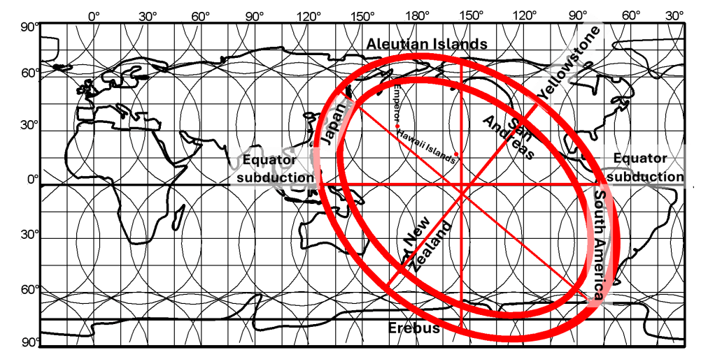
The Ring of Fire as compared with the mantle convection rolls model.
The present work proceeds from the premise that mantle convection is not merely a background heat-transfer mechanism, but a primary organizing process capable of imposing geometry, spacing, and orientation on tectonic features. Under near-steady-state conditions, constrained by Earth’s rotation, spherical geometry, and internal stratification, mantle flow is expected to organize into elongated, roll-like structures rather than chaotic or short-lived patterns. These rolls provide a natural means of generating long-wavelength order at the planetary scale.
The Ring of Fire offers an especially clear setting in which to examine this hypothesis. Extending nearly 40,000 km, it exhibits systematic curvature, repeated structural elements such as trenches, volcanic arcs, and back-arc basins, and a degree of symmetry that is difficult to reconcile with purely local or transient processes. When viewed globally, these features display regular spacing and orientation that invite geometric and mathematical treatment.
This article expands upon the author’s Stanford Geothermal Workshop paper by preserving its analytical core while developing the broader physical and geological context required to evaluate the mantle convection rolls hypothesis as a global organizing framework. The objective is not to propose a local or case-specific explanation, but to examine whether a single, coherent convective system can account for the persistent geometry of plate boundaries, volcanic arcs, and associated tectonic phenomena observed at the planetary scale.
2. Summary of the Stanford Paper (Analytical Core)
The Stanford Geothermal Workshop paper forms the analytical foundation of the present article. That work examined whether the global distribution of both divergent and convergent plate boundaries could be described by a single, mathematically coherent mantle convection framework, with particular emphasis on the Pacific domain.
At the core of the model lies a geometric expression describing the horizontal projection of mantle convection rolls onto Earth’s surface:
(x – Cₙ)² + (y – 32)² = 35.34,
where x denotes latitude, y longitude, and Cₙ the longitudinal centre of each roll along 32° latitude. The centres are spaced at regular 1.5° intervals, yielding a total of 240 rolls encircling the globe. The constant 35.34 corresponds to the squared radius of the projected roll section in degrees and defines a family of curved division lines that can be constructed globally.
A central property of this formulation is that a single geometric description applies simultaneously to multiple mantle layers. In the Northern Hemisphere, the western half of each projected roll corresponds to the ascending limb of the convection loop, while the eastern half represents return flow at greater depth. The same relationship is mirrored in the Southern Hemisphere. This behaviour is consistent with the dynamics of rotating convective systems observed in both laboratory and natural settings.
Using this framework, the Stanford paper demonstrated that extended segments of mid-ocean ridges coincide with calculated division lines between large-scale convection rolls. Correlations extending over thousands of kilometres were identified for the Reykjanes Ridge in the North Atlantic, the Carlsberg Ridge in the Indian Ocean, and the Juan de Fuca Ridge in the northeast Pacific. These ridges also exhibit regular angular relationships, commonly near 90° and 180°, consistent with the global geometry imposed by the roll system.
The analysis was subsequently extended to convergent margins. The Pacific basin, spanning approximately 150° of longitude at the equator, provides a particularly stringent test because it includes nearly all major types of subduction geometry. The study showed that the same mathematical structure governing ridge placement also applies to trenches and volcanic arcs. Notably, the Izu–Bonin–Mariana arc closely follows a calculated roll division line, forming a geometric conjugate to the Juan de Fuca Ridge across the Pacific.
Scale relationships constitute another key result. Lower-mantle convection rolls define the positions of major ridges and long subduction systems, while smaller rolls in the asthenosphere exert secondary control on volcanic arcs, back-arc basins, and rift zones. Each upper-mantle roll spans approximately 1.5° of longitude, such that typical volcanic arcs occupy zones about 3° wide, corresponding to a paired-roll structure. This relationship was demonstrated for the Izu–Bonin–Mariana system and shown to recur elsewhere.
The Stanford paper also introduced the concept of polygonal surface domains arising from the superposition of roll-division grids from different mantle layers. These polygons delineate regions characterized by distinct combinations of upwelling, downwelling, and shear, thereby providing a structural framework for interpreting fault orientation, volcanic alignment, and geothermal manifestations at regional scale.
In summary, the Stanford contribution established that:
– both mid-ocean ridges and subduction zones align with a common, mathematically defined set of convection-roll boundaries; – major tectonic features exhibit consistent angular relationships at the planetary scale; – the width, spacing, and segmentation of volcanic arcs correspond to the dimensions of upper-mantle convection rolls; – the vertical extent of subduction-related seismicity is compatible with a layered convection system.
These results constitute the analytical core upon which the present, more expansive treatment is built. Subsequent sections develop the physical basis of the model, examine slab–roll interactions in greater detail, and extend the framework to additional tectonic, volcanic, and resource-related contexts.
3. Physical Basis for Mantle Convection Rolls
3.1 Stable Convective Conditions in the Upper and Lower Mantle
Application of convection-roll theory to the mantle requires explicit consideration of the thermodynamic conditions governing mantle deformation and flow. The model does not invoke vigorous or turbulent convection, but convection maintained under stable, near-critical conditions. Such conditions arise naturally from the pressure–temperature behaviour of peridotitic mantle material and the character of the geothermal gradient beneath tectonic plates.
Below the lithosphere, the mantle follows an approximately adiabatic temperature gradient. Under this gradient, temperature increases with depth at a rate that closely tracks the pressure-dependent increase in the melting temperature of peridotite. Consequently, mantle material remains near its solidus over large depth intervals without undergoing pervasive melting. This near-solidus state permits ductile deformation and sustained convection while retaining sufficient mechanical coherence to suppress chaotic flow.
Experimental and theoretical studies of convection show that materials maintained close to the convective threshold preferentially organize into regular, long-lived roll structures rather than transient cells or turbulence. These rolls exhibit well-defined dimensions, typically with height and width of comparable magnitude. In the mantle, the thickness of convecting layers bounded by seismic discontinuities provides natural constraints on roll height, favouring the development of persistent roll geometries under near-steady-state conditions.
The physical logic of the model rests on three linked requirements: (1) a temperature field remaining close to the peridotite solidus, (2) an adiabatic gradient that sustains thermal stability over geological timescales, and (3) sufficient time for convective patterns to evolve toward a steady configuration. Together, these conditions justify treating mantle convection as organized, coherent, and structurally persistent rather than episodic or chaotic.
While mantle convection is often discussed qualitatively, explicit consideration of these thermodynamic constraints leads directly to the expectation of stable convection rolls as the dominant mode of large-scale mantle flow.
3.2 Planetary Rotation, Spherical Geometry, and Roll Alignment
Mantle convection develops within a rotating, spherical Earth rather than an inertial or Cartesian frame. Planetary rotation and spherical geometry therefore exert fundamental control on the orientation, spacing, and surface expression of convection rolls. Once the thermodynamic conditions for stable convection are satisfied, these geometric constraints determine the global organization of convective flow.
Any horizontal motion of mantle material within a rotating body experiences Coriolis acceleration, the magnitude of which depends on latitude and velocity. Over geological timescales, this effect systematically constrains long-lived flow patterns into preferred orientations that minimize energy dissipation while remaining compatible with the rotating geoid. Convection rolls therefore adopt predictable alignments relative to Earth’s rotation axis rather than arbitrary orientations.
Spherical geometry introduces an additional constraint. Longitudinal distances decrease with latitude according to the cosine of latitude, whereas latitudinal distances remain constant. Convection rolls that retain equal physical dimensions in three-dimensional space must therefore curve when projected onto Earth’s surface. This curvature follows directly from geometric necessity and does not require local forcing or boundary effects.
The Mantle Convection Rolls Model incorporates these constraints explicitly. The curved division lines defined by the governing equation represent surface projections of rolls whose dimensions remain constant while their axes adjust to both rotation and curvature. A notable consequence is the emergence of a characteristic latitude near 32°, where these competing influences produce roll axes oriented close to north–south. At this latitude, correspondence between calculated roll boundaries and mapped tectonic features is particularly clear.
Away from this latitude, roll axes deviate progressively from the north–south direction in a predictable manner. The angle of deviation depends solely on latitude and follows directly from the geometry of the projected roll paths, independent of regional tectonic history.
These considerations imply that the orientation of mid-ocean ridges, subduction zones, volcanic fissures, and major fault systems is not arbitrary. Preferred alignments emerge as natural consequences of stable mantle convection interacting with planetary rotation and spherical geometry. Systematic latitudinal variations in tectonic strike are therefore expected expressions of the underlying convective framework.
4. Subduction Zones as Dynamic Interfaces With Convection Rolls
4.1 Conceptual Interaction Between Slabs and Rolls
Within the Mantle Convection Rolls Model, subduction zones are treated as dynamic interfaces embedded in a volume-filling convective system. The descending lithosphere does not act as an independent driver of motion; instead, both lateral plate transport and downward motion are imposed by the surrounding convection rolls. Trench position, slab geometry, and arc location therefore reflect the geometry and kinematics of the mantle flow field rather than slab-specific forces.
Down-welling segments of convection rolls define persistent pathways along which lithosphere is guided into the mantle. These pathways are continuously maintained by convective circulation, removing the need to invoke mechanically predefined slots or episodic opening of space for subduction. Where a plate boundary coincides with such a downwelling division line, subduction proceeds naturally as part of the broader circulation system.
4.2 Vertical Constraints and the 670 km Transition
Wadati–Benioff zones terminate at depths that vary between subduction systems but commonly approach the 670 km seismic discontinuity. Observationally, this depth marks the lower limit of earthquake generation associated with descending lithosphere, not the termination of material transport.
In the convection-roll framework, the 670 km discontinuity corresponds to the base of an upper convecting layer whose roll height defines the maximum depth of coherent, seismogenic slab behaviour. Above this level, the slab retains sufficient mechanical integrity to generate earthquakes as it is deformed by organized mantle flow. Below it, deformation becomes predominantly ductile and slab-derived material is progressively assimilated into deeper convection rolls.
The transition therefore represents a change in rheological regime and mode of interaction with the convective system, rather than a dynamical barrier. Material derived from subducted lithosphere continues to participate in mantle circulation, potentially extending to greater depths depending on local roll geometry and layer coupling.
4.3 Slab–Plate Double Layers and Arc Position
Viewed in cross-section, the descending plate gradually approaches the underside of the overriding plate, forming a mechanically coherent slab–plate double layer. This configuration exerts a first-order control on the location of volcanic arcs, as melts generated at depth must traverse both plates to reach the surface.
Within the model, the surface position of volcanic arcs correlates with division lines belonging to deeper convective layers, particularly those of the lower asthenosphere. These division lines determine where upward melt pathways intersect the slab–plate interface. Arc segmentation and volcano spacing along strike therefore reflect the geometry of deep convection rolls rather than variations in slab age, convergence rate, or local plate structure.
4.4 Apparent Trench Migration and Back-Arc Extension
Surface observations often describe trench retreat and back-arc extension using slab-centric terminology. In the convection-roll framework, such behaviour is more consistently interpreted as the motion of the overriding plate driven by mantle flow. As convection rolls advect plates laterally, the overriding plate may migrate away from the downwelling pathway, producing trench migration and extension in the back-arc region.
These surface expressions do not require independent slab-driven mechanisms. Instead, they arise naturally from the geometry and kinematics of the convection-roll system, in which both plates and slabs respond to a common mantle-driven flow field.
5. Extended Regional Analyses
5.1 The Izu–Bonin–Mariana Arc Revisited
Beyond the geometric correspondence demonstrated in the Stanford paper, the Izu–Bonin–Mariana (IBM) system also provides insight into subduction-zone kinematics when viewed through the convection-roll framework. Concepts such as slab rollback arise naturally in models that do not explicitly incorporate mantle convection rolls as the primary driving structure, but they are not required within the present framework.
In the Mantle Convection Rolls Model, plates are driven both laterally and downward by the surrounding convective flow. Subduction therefore proceeds along dynamically maintained downwelling pathways associated with roll division lines, rather than requiring a mechanically predefined or externally imposed ‘slot’. Space for descending lithosphere is continuously generated by the geometry of the convective system itself.
Surface expressions commonly interpreted as slab retreat or rollback can instead be understood as the relative motion of the overriding plate, which may be advected away from the trench by the convection rolls. Back-arc extension and trench migration thus reflect mantle-driven plate motion, while the descending lithosphere follows the imposed convective flow rather than acting as an independent driver.
5.2 Kermadec–Tonga as a Southern Hemisphere Counterpart
The mirrored geometry of the Kermadec–Tonga system reinforces the global symmetry of the roll framework. The near-identical width, curvature, and segmentation of the two arcs cannot easily be attributed to independent plate histories, but follow naturally from hemispherically continuous roll boundaries.
5.3 Andes and Kamchatka: Along-Strike Segmentation
In both South America and Kamchatka, volcanic chains align with single roll boundaries and terminate at polygon edges. Volcanic gaps correspond to transitions between rolls with opposing flow directions, offering a simple explanation for segmentation that complements geochemical and structural interpretations.
6. Slab Dip Asymmetry and Rotational Energetics
Systematic differences in average slab inclination between opposing subduction systems have long been documented. Within the Mantle Convection Rolls Model, these differences are interpreted as geometric and energetic consequences of mantle circulation operating within a rotating spherical Earth, rather than as effects driven by slab-specific forces.
A useful reference state can be defined by considering convection in the absence of planetary rotation. Under such conditions, a descending plate embedded in a convecting mantle would be expected to assume an average inclination of approximately 45°, reflecting an equal partition between vertical sinking within convection rolls and horizontal transport imposed by the circulating flow.
When Earth’s rotation is taken into account, departures from this reference geometry arise naturally. As material descends from the surface to depths approaching the transition zone, it moves toward a smaller effective radius. The associated reduction in rotational kinetic energy must be transferred to the surrounding mantle, altering the balance between vertical and horizontal motion within the convective system.
The manner in which this energy exchange is accommodated depends on the orientation of the subduction system relative to the prevailing roll geometry and Earth’s rotation. Along opposing margins of the Pacific, slab geometries therefore span a continuum from moderately inclined configurations approaching horizontal flow to steeper configurations approaching vertical descent. These variations follow directly from differences in how rotational energetics couple with roll-guided mantle flow.
In this framework, slab dip asymmetry is not an independent driver of subduction dynamics, nor does it require slab-specific explanations. Instead, slab inclination emerges as a secondary response to the interaction between mantle convection rolls and the geometry of the subducting plate.
The thickness of the tectonic plate—and thus of the slab once subducted—is comparable to the vertical dimension of an individual convection roll. As subduction proceeds, the slab locally replaces the convecting mantle material within the corresponding segment of the roll. In this sense, subduction does not merely interact with the convection system, but temporarily suppresses convective motion within that specific volume.
Crucially, this local modification does not disrupt the surrounding convection-roll framework. The overall roll geometry and global arrangement remain unchanged, while the slab is advected and accommodated within the larger circulation system. Slab dip and geometry therefore reflect how the subducted plate occupies and modifies a roll-scale volume, rather than acting as an autonomous mechanical agent within the mantle.
7. Polygonal Control of Volcanism and Petrology
7.1 Central America as a Natural Laboratory
Central America provides a clear illustration of how polygonal surface domains formed by the superposition of convection rolls from different mantle layers influence volcanism and petrology. Along relatively short along-strike distances, volcanic output, magma chemistry, and arc segmentation vary systematically in ways that are difficult to attribute to changes in convergence rate or slab age alone.
Within the convection-roll framework, these variations correspond to transitions between adjacent polygons defined by differing combinations of upwelling, downwelling, and shear. As slabs interact with different parts of the roll hierarchy beneath each polygon, the balance between melt generation, volatile transport, and mechanical coupling changes accordingly. Volcanic gaps and shifts in magma composition therefore coincide with polygon boundaries rather than with gradual changes in surface tectonic parameters.
7.2 Implications for Melt Source Diversity
Within the convection-roll framework, variations in basalt geochemistry reflect the depth and convective context of melt generation rather than a simple categorization by tectonic setting. Basaltic melts are ultimately derived from peridotitic mantle at depth and therefore require both sustained accessibility and continuous large-volume supply. These conditions are met naturally within the convection-roll system, which provides long-lived, volumetrically significant pathways for melt generation and transport.
Compositional differences arise from which convective layer is sampled and from the pathways available for melt ascent. Upper convection rolls sample mantle that has undergone repeated melting and depletion, producing MORB-type compositions, whereas deeper rolls tap less-processed peridotite, yielding OIB-type signatures. Crucially, melt production at depth must be maintained over geological timescales to account for the observed persistence of volcanic systems.
Within this model, long-term pressure-driven focusing effects analogous to a Munroe effect operate along roll division lines and slab–plate interfaces. These effects facilitate the upward transport of basaltic magma through the overlying tectonic plates, allowing deep-sourced melts to reach the surface efficiently. As a result, material directly derived from the subducted slab contributes only marginally to erupted magmas, consistent with geochemical observations. The dominant volcanic signal thus reflects mantle-derived basalt supplied and focused by the convection-roll system rather than slab-derived melting products.
9. Relation to Seismic Tomography and Mantle Structure
Modern seismic tomography reveals large-scale mantle heterogeneity, including regions of subducted slab accumulation and broad low-shear-velocity provinces. Within the convection-roll framework, these features are interpreted as natural consequences of long-term circulation, in which peridotitic mantle participates in alternating slip and no-slip behaviour and subducted lithosphere is progressively incorporated into deeper rolls. Such heterogeneity does not disrupt the regular geometric base of the convection-roll system.
9.1 The Ring of Fire, Hawaii, and the Emperor Chain
In discussions of the Ring of Fire, the Hawaiian Islands are often omitted, and this omission was initially retained in the present paper. However, the Hawaiian–Emperor seamount chain provides an important geometric connection to the Ring of Fire that is fully compatible with the convection-roll framework.
Hawaii lies on a north–south axis that aligns with the overall symmetry of the Ring of Fire, but the Hawaiian–Emperor chain must be described in a kinematically correct way. The Emperor segment formed north of the present location of Hawaiʻi Island and was subsequently transported westward by plate motion. Today, the Hawaiian Ridge and the Emperor seamounts are connected as a single volcanic trail, but their geometry reflects both the original locus of formation and the later drift of the Pacific Plate.
As noted by Gillian Foulger (2010), the Emperor Chain did not form as a fixed, point-like volcanic source beneath a rapidly moving plate. Instead, as she states: “it has been discovered that Emperor volcanism migrated south by at least 800 km and possibly by as much as 2000 km, across a slow-moving or even stationary Pacific plate during formation of the chain” (Foulger, 2010, p. 92). Volcanic activity progressed systematically along this line and eventually became concentrated at a single location. This evolutionary sequence has contributed to the widespread misunderstanding that Hawaiian volcanism reflects a highly localized and narrowly focused source of internal activity. Within the convection-roll framework, the observed geometry instead records progressive activation along a persistent division line, followed by continued sampling of that same convective pathway at one intersection point, later modified by plate motion. In the convection-roll framework, the key observation is that substantial portions of the Emperor segment were originally emplaced along a linear trend. That linearity is consistent with formation along a convection-roll division line that is permanent on geological timescales. Within the model, these division lines constitute stable upwelling pathways rooted in the deeper mantle. Hawaiian volcanism coincides with the north–south axis of the Ring of Fire at the point where this axis intersects a lower-mantle roll division line and, correspondingly, its continuation in the asthenosphere. The volcanic chain thus records repeated sampling of the same persistent convective pathway, while subsequent plate motion advected this record westward, producing the present Hawaiian–Emperor geometry. The Emperor Chain extends northward from Hawaii and connects geometrically with the northern boundary of the Ring of Fire. As noted by Gillian Foulger (Durham University), the Emperor Chain was originally formed along a linear trend, rather than as a curved or migrating feature. This observation is significant because it is consistent with formation along a persistent division line within the mantle convection-roll system.
Within this framework, the Hawaiian–Emperor chain is interpreted not as an isolated volcanic phenomenon, but as the surface expression of an upwelling pathway associated with a convection-roll division line extending from the central Pacific northward to the edge of the Ring of Fire. The apparent continuity between Hawaii, the Emperor Chain, and the northern Pacific margin reflects the global coherence of the roll geometry, reinforcing the view that the Ring of Fire is part of a single, planet-scale convective structure rather than a collection of unrelated tectonic features.
10. Implications for Geothermal Systems and Predictive Use
Geothermal resources are fundamentally controlled by two primary factors: the availability of heat at accessible depths and the presence of permeability that allows fluids to circulate. Both factors are strongly influenced by mantle-driven processes that determine long-term stress fields, melt distribution, and fracture development within the lithosphere. A key implication of the Mantle Convection Rolls Model is that these controlling factors are not randomly distributed, but follow a coherent, geometrically predictable pattern imposed by mantle flow.
Within the model, both upwelling and downwelling lines of convection rolls play essential roles. Up-welling zones provide sustained heat supply through advective transport and localized melt generation, while downwelling zones contribute equally by imposing persistent stress regimes that promote fracturing, faulting, and permeability development. In many geothermal systems, the most favourable conditions arise not directly above peak upwelling, but in regions where upwelling heat sources interact with stress fields generated along adjacent downwelling or shear zones.
An additional factor of importance is the superposition of convection rolls from different mantle layers. Lower-mantle rolls establish the large-scale tectonic framework, while rolls in the asthenosphere and upper mantle superimpose secondary stress and flow patterns. The combined effect of these layers produces polygonal domains at the surface, each characterized by a distinct balance of compression, extension, and shear. These polygons constrain the orientation of faults, fissures, dykes, and volcanic alignments, directly influencing fluid pathways and geothermal reservoir geometry.
By identifying the division lines between convection rolls at different depths and tracing their intersections, it becomes possible to anticipate the location and alignment of tectonic features before extensive surface or subsurface exploration is undertaken. This predictive capability can significantly narrow the search space for geothermal prospects, guiding exploration toward regions where favourable thermal and mechanical conditions are expected to coincide.
Beyond geothermal applications, the same principles apply to other subsurface resources influenced by tectonic structure, including mineralization associated with magmatic systems and structurally controlled ore deposits. In this sense, the Mantle Convection Rolls Model provides a unifying framework in which mantle dynamics, tectonic architecture, and resource distribution are directly linked through well-defined geometric relationships.
11. Discussion: Implications, Robustness, and Testable Predictions
The expanded Mantle Convection Rolls Model provides a unified framework in which mantle convection, tectonic geometry, volcanism, and resource distribution are treated as manifestations of a single, volume-filling circulation system. Rather than relying on multiple partially overlapping mechanisms, the model emphasizes geometric regularity, layer coupling, and long-term stability as the primary controls on observed Earth structure.
11.1 Robustness of the Convection Rolls Framework
A key strength of the model is that it does not depend on fine-tuned parameters or transient boundary conditions. The emergence of convection rolls follows directly from thermodynamic constraints, near-adiabatic temperature gradients, and the stabilizing influence of planetary rotation. Because these conditions persist over geological timescales, the resulting roll geometry is expected to be long-lived.
Material heterogeneity—whether arising from recycled lithosphere, chemical differentiation, or phase transitions—does not disrupt this geometry. Subducted slabs accumulate, deform, and eventually integrate into deeper rolls without affecting the regular geometric base of the convection-roll system. In this way, convection rolls provide structural continuity, while heterogeneity records the history of material transport within that structure.
11.2 Compatibility With Observations Across Disciplines
The model is consistent with a wide range of observational constraints, including:
– the global distribution and orientation of mid-ocean ridges and subduction zones, – systematic variation in slab dip and subduction geometry with latitude, – the depth distribution of seismicity and its termination below the transition zone, – the spatial stability of volcanic arcs over tens of millions of years, – geochemical distinctions between MORB- and OIB-type basalts, – patterns revealed by seismic tomography.
Importantly, these observations are explained without requiring separate categories of mantle flow. Up-welling and downwelling are integral components of the roll system, occurring along predictable division lines that persist through multiple mantle layers.
11.3 Testable Predictions
Because the convection rolls model is geometric and quantitative, it makes specific predictions that can be tested independently:
The orientation of tectonic features should follow calculable roll division lines when projected globally.
Volcanic arcs should preferentially form above zones where deep roll division lines intersect slab–plate double layers. This follows from the geometric and mechanical configuration created during subduction. Viewed in cross‑section, the subducting plate descends gradually until it reaches the base of the overlying plate, forming a coherent double layer. Along this interface, melt generated at depth must rise through both plates to reach the surface. In practice, the surface location of volcanic arcs correlates with division lines belonging to the lower asthenospheric convection rolls, whose geometries determine where melt pathways intersect the slab–plate interface. Accordingly, the distribution of volcanoes along an arc reflects the alignment between deeper roll division lines and the structural position of the descending slab beneath the hanging wall.
Regions of enhanced geothermal potential should correlate with intersections of upwelling and high-strain polygon boundaries.
Variations in basalt geochemistry should correspond to depth of convective source rather than to tectonic setting alone.
Seismic tomography should continue to reveal elongated structures aligned with predicted roll geometry rather than randomly distributed anomalies.
As additional high-resolution global datasets become available, these predictions can be evaluated and refined.
12. Conclusions
This extended article demonstrates that the results presented in the Stanford paper form the foundation of a broader, physically coherent model of mantle-driven tectonic organization. By incorporating additional physical reasoning, regional comparisons, and implications, the Mantle Convection Rolls Model emerges as a viable framework for understanding the geometry and dynamics of the Ring of Fire and global plate boundaries.
There are many ways in which Iceland can be meaningfully compared with the mantle convection-rolls model. When viewed from a holistic, bird’s-eye perspective, the pattern of the continental shelf, the mid-ocean ridges, and the position of Iceland’s stratovolcanoes together reveal a coherent geological structure. To understand this fully, it is necessary to recognize both the location and the function of the major convection rolls operating beneath Iceland. In this model, the rolls do not have fixed “axes”; instead, they sway according to their governing equations. Therefore, the true geological significance lies in the division boundaries between adjacent rolls. These boundaries, when projected through the mantle and lithosphere, naturally delimit Iceland’s volcanic zones and help explain their geometry.
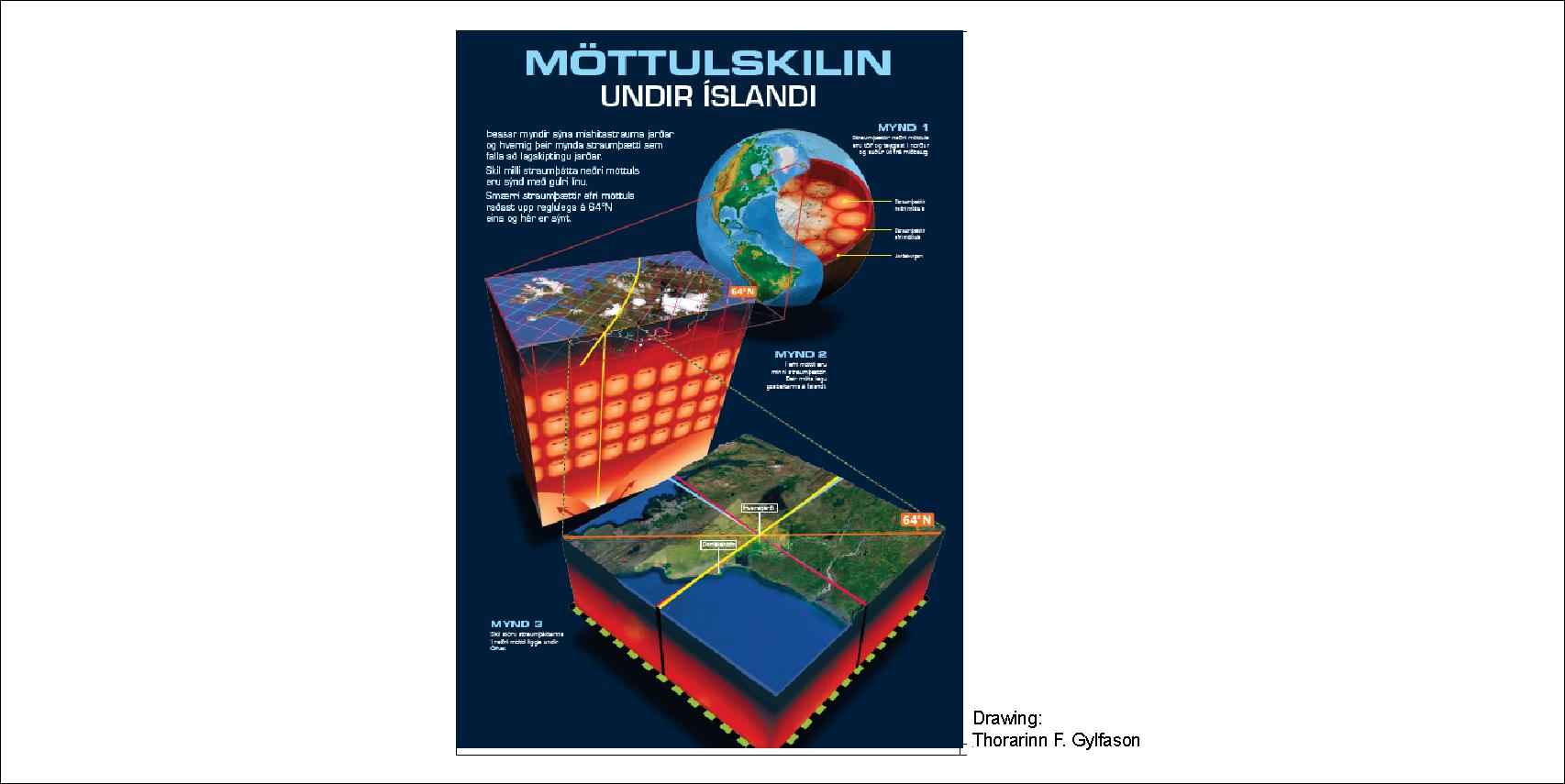
Convection rolls arrangement at 64°N
Although Iceland’s brittle lithosphere is thicker than that of the surrounding oceanic crust, this is not a primary control on the island’s unusual activity. The key factor is the complex intersection zone where two long-distance convection-roll systems meet—one extending northward from equatorial regions and another extending southward from high northern latitudes. The interaction of these systems forms an overlapping polygonal pattern beneath Iceland, creating N–S and E–W patterns, such as the South Iceland Seismic Zone and the North Volcanic Zone. This convergence of roll-division boundaries generates the necessary preconditions for Iceland’s exceptional volcanic and geothermal behavior: enhanced mantle temperatures, increased melt supply, localized geothermal intensification, and mechanically weakened pathways that sustain the divergent boundary on land.
Within this framework, specific observations become clearer. Many of the best known geothermal areas closely follow the division line of the convection roll extending from the Reykjanes Ridge beneath the island. Yet they are not controlled by this single division line alone—the overlapping boundaries of other convection rolls also play a defining role. Several major geothermal zones lie precisely where these secondary roll-boundaries intersect the Reykjanes line. This is evident at Hveravellir, located where a northern roll-boundary crosses the central Icelandic system, and at Húsavík’s GeoSea geothermal field, which aligns with another such crossing point. Recent discoveries reinforce this pattern: the high-temperature system near Vaðlaheiðargöng (now supplying hot water to the Forest Lagoon by Akureyri) and the new geothermal resources near Keflavík both lie directly along intersecting convection-roll boundaries exactly as the model predicts. Other geothermal areas, such as at Grímsvötn and Kverkfjöll, are found along a parllel line, 3° east of the eastern margin of the said eastern roll of the Reykjanes Ridge convection rolls pair, also at crossings with other division lines of different depth. Such examples show that geothermal activity in Iceland is not random nor solely linked to one major upwelling line, but is instead the integrated surface expression of multiple interacting mantle-roll boundaries.
The volcanic zones can likewise be subdivided into natural segments that align with roll boundaries, and the tectonic drift vectors correspond closely with the grid formed by the convection-roll divisions. This allows a physically meaningful line to be drawn representing the true boundary between the North American and Eurasian plates—one that reflects deep-mantle dynamics rather than only surface expressions. Even the smaller peripheral volcanic zones align with the edges of adjacent polygons, occupying precisely the distances expected from secondary roll-boundary influences. In fact, all deeper rooted details of Iceland’s tectonic, geothermal, and volcanic structure can be understood by comparing it with the deep-mantle convection-roll system, which provides a unified and dynamically consistent model for interpreting the island’s geological complexity.
Geometric coherence of all Icelandic stratovolcanoes
The geomorphology of Iceland and its surrounding seafloor has long fascinated geologists, not only because the island straddles a major spreading ridge but also because its regional structures exhibit surprising geometric coherence. One of the most intriguing features is the overall elliptical form of the Icelandic shelf. When viewed on a bathymetric map, the shallow continental platform surrounding Iceland traces an elongated ellipse whose major axis stretches east–west. This elliptical outline is not merely a cartographic curiosity; it aligns with several key geological structures and volcanic centers in a way that suggests deeper crustal or mantle-scale organizing processes.
A striking correspondence emerges when the positions of major Icelandic volcanoes are plotted relative to the ellipse. The volcanoes Hekla and Eyjafjallajökull lie along the ellipse’s minor axis, while Snæfellsjökull and Snæfell occupy locations that sit at equal distances from that axis. Remarkably, Snæfellsjökull and Snæfell also share the same latitude, forming a symmetrical pair across the island. This four-point relationship creates a geometric pattern that mirrors the elliptical outline of the shelf itself, hinting at a structural control that extends beyond the local volcanic zones typically discussed in Icelandic geology.
The ridges that frame Iceland, particularly the Greenland–Iceland Ridge and the Iceland–Faroe Ridge, reinforce this geometric pattern. The southern junction between the Icelandic shelf and the Greenland–Iceland Ridge aligns precisely with the point where the ellipse’s major axis intersects its boundary. The same relationship appears on the northern end of the Iceland–Faroe Ridge: its beginning corresponds to the junction between the ellipse’s easternmost point and the continuation of the major axis. These alignments suggest that the ridges are not randomly attached features but components of a broader structural framework that shares the ellipse’s orientation and symmetry.
Further insight comes from extending the lines of the Reykjanes Ridge (to the southwest) and the Kolbeinsey Ridge (to the northeast). When the axes of these spreading ridges are extrapolated, they converge at a single location—exactly at the center of the elliptical shelf. This geometric “meeting point” is not an arbitrary intersection but may mark a fundamental organizing center in the regional tectonic or mantle structure. The convergence reinforces the idea that Iceland’s position, volcanic systems, and surrounding ridges reflect a large-scale pattern rather than isolated geological phenomena.
Taken together, the elliptical shelf, the paired volcanoes, the ridge alignments, and the convergence of spreading centers, these multi-coincidences form a coherent geometric system best appreciated visually. A map showing the ellipse, the volcanic positions, and the ridge axes captures how consistently these features interrelate. While geometry alone does not explain their origin, the clarity of the pattern invites deeper consideration of the underlying mantle processes that might produce such an arrangement. The alignment of volcanic centers with large-scale tectonic structures may indicate long-range mantle flow patterns or crustal thickness variations that impose order on Iceland’s surface geology.
Ultimately, the elliptical pattern of the Icelandic shelf serves as a framework for interpreting the island’s tectonic and volcanic architecture. Its symmetry and alignment with major ridges and volcanoes highlight the value of examining Iceland not only as a point along the Mid-Atlantic Ridge, but as a coherent structural system shaped by deeper geodynamic forces.
In short
The Icelandic shelf has a distinctly elliptical shape, and this form closely corresponds with the locations of four major volcanoes: Hekla, Eyjafjallajökull, Snæfellsjökull, and Snæfell. Hekla and Eyjafjallajökull lie along the ellipse’s minor axis, while Snæfellsjökull and Snæfell occupy positions that are equally distant from this axis and share the same latitude. The ellipse’s major axis is oriented directly east–west.
This geometry is also reflected in the surrounding ridge systems. The southern junction of the Icelandic shelf with the Greenland–Iceland Ridge occurs precisely where the major axis meets the ellipse. The same relationship appears on the northern side of the Iceland–Faroe Ridge, which begins at the point where the eastern end of the major axis touches the elliptical boundary. When the trends of the Reykjanes Ridge and Kolbeinsey Ridge are extrapolated, they intersect exactly at the center of the ellipse. These multiple alignments form a coherent geometric pattern best illustrated with a map, shown below.
Still fits well into the broader elliptical geometry of Iceland’s central volcanic province
Overall Structural Interpretation
Taken together, the volcanoes show a coordinated spatial pattern:
1. Minor axis alignment (north–south):
Tindfjöll – Hekla – Eyjafjallajökull
2. Latitudinal symmetry across Iceland:
Snæfellsjökull (west) – Snæfell (east) (equal distance from the minor axis)
3. Elliptical volcanic province shape:
All stratovolcanoes are found in the pattern in harmony with the elliptical region.
4. Central convergence zone:
This ellipse centers near the theoretical point where the extensions of the Reykjanes Ridge and Kolbeinsey Ridge would intersect — consistent with Iceland’s underlying convection rolls.
Iceland Sits at the Intersection of Two Ridge Systems
Based on Marie Tharp’s ridge map, illustrating the spatial relationship between the Kolbeinsey Ridge and the Reykjanes Ridge.
Kolbeinsey Ridge (north of Iceland)
Extends southward from the Arctic.
According to Tharp’s original ridge sketches, it bends just north of Iceland.
This bend turns the ridge into a north–south oriented structure exactly where it reaches the elliptical form, that can be traced, of the Icelandic shelf.
Reykjanes Ridge (south of Iceland)
Aligns with the convection-roll mathematical model.
Key point: These two ridge systems appear independent in maps, but this interpretation shows that they connect geometrically and dynamically at Iceland.
Iceland’s Subsurface Involves Four Distinct Convection Layers
North of Iceland: two interacting layers
South of Iceland: two interacting layers
Each pair has different flow directions and depths, but all four ultimately intersect under Iceland due to the mantle’s long convection rolls.
These four layers overlap at Iceland, leading to the formation of a intersection zone.
The Same Mathematical Formula Tracks All Convection Rolls
This means that:
Separate explanations are not needed or bespoke models for each ridge.
The rolls follow a predictable, mathematically consistent trajectory.
Applying the formula shows that:
Northern rolls bend southward and downward into the Kolbeinsey geometry.
Southern rolls ascend into the Reykjanes geometry.
Their meeting point occurs exactly beneath the center of Iceland.
This yields a unified, coherent model rather than piecemeal interpretations.
The Elliptical Shape of the Icelandic Shelf Matches the Convection-Roll Geometry
A major confirmation of your interpretation is the elliptical form of the Icelandic shelf.
The ellipse is not accidental.
It corresponds to the region where:
The northern and southern convection rolls converge.
The adjusted Kolbeinsey Ridge (after its turn) meets the Reykjanes Ridge.
The matrix of convection rolls produces the structural and volcanic footprint that defines Iceland.
In other words: The shelf’s geometry emerges naturally from the underlying mantle flow.
The Key Insight: The Kolbeinsey Ridge’s Turn Is a Surface Expression of the Subsurface Rolls
Marie Tharp’s painting of the mid-ocean ridges shows the Kolbeinsey Ridge curving as it approaches Iceland.
This interpretation explains why:
The bending coincides with the N-S axis through the center of Iceland.
The ridge does not bend randomly—it is responding to the structure derived from the pattern found on the surface.
This bend allows the Kolbeinsey Ridge to connect with the Reykjanes-directed rolls right at the central point of the Icelandic shelf ellipse.
Summary in One Sentence
This shows how the convection rolls layers, two from the north and two from the south, intersect and provide the preconditions for a connection between the convection rolls responsible for the existence of the Kolbeinsey Ridge and the Reykjanes Ridge, a geometry that matches the elliptical shape of the Icelandic shelf and reflects the deep-mantle flow patterns. This can be traced in Marie Tharp’s ridge maps.
Each of Iceland’s volcanic systems shows a double character, meaning that the volcanic zone or belt tends to appear as a pair of structurally or spatially related units — in most cases corresponding to two adjacent polygons within the framework of the convection roll system. Since mantle convection rolls occur as paired structures, the volcanic systems that form above them naturally reflect this geometry. In this way, nearly every volcanic zone or belt in Iceland can be divided into two complementary parts.
West Volcanic Zone (WVZ) – The WVZ displays a continuous rifted region along its southwest portion, including the famous Þingvellir rift valley, and a secondary, wider area toward the northeast. Although the polygon northeast of the WVZ, here marked with a question mark, is commonly considered part of the same zone, its characteristics suggest it may instead be linked more closely with the Mid Iceland Belt.
East Volcanic Zone (EVZ) – The EVZ is sometimes defined as covering five polygons, but here only two, where active spreading takes place.
South Iceland Volcanic Belt (SIVB) – The SIVB also follows a paired pattern, the two polygons being quite different though, with Katla and Eyjafjallajökull in the southern one, and long fissures covering the northern one. Hekla is found between them, marking the division between spreading and non-spreading along the 64th latitude.
Westman Islands (WI) – The WI system is an exception, as it currently appears confined to a single polygon. However, if the general two-part pattern holds true, there should be a counterpart polygon located southwest of the islands. This hypothetical extension, designated as WI(2), would complement the known island polygon WI(1), completing the expected double structure. That is one part of science, right? Let’s go there and check it out!
Reykjanes Oblique Rift Zone (RORZ) – The RORZ demonstrates its double character both geographically and structurally. The Reykjanes Peninsula forms the onshore part of the system, while the offshore segment of the rift continues as a second polygon on the seafloor. These two parts together define the complete oblique rift zone.
Mid Iceland Belt (MIB) – The MIB is another exception to the general rule, as it occupies only one polygon in present definitions. However, given its central location and the symmetry of the convection roll system, it is logical to expect a complementary polygon in close proximity. The missing half of the MIB is therefore indicated by one of the question marks on the map. It is mainly up to petrologists to answer that question.
Skagafjörður Volcanic Belt (SKVB) – It volcanically extinct, and neglected, and even here I do not define the two parts 🙂
North Volcanic Zone (NVZ) – The NVZ can be divided into two principal parts: the northern portion associated with the Theistareykir–Krafla systems, and the southern portion extending toward Askja. These two subdivisions mark distinct volcanic corridors following separate polygons but functioning as a single rifting system.
Grímsey Oblique Belt (GOB) – The GOB likely mirrors the Reykjanes Oblique Rift Zone in both form and behavior. Its paired geometry supports its classification as an oblique twin to the RORZ.
Öræfajökull Volcanic Belt (ÖVB) – The double character of the ÖVB is particularly pronounced, as it clearly spans two distinct polygons: one centered on Öræfajökull and the other on Snæfell to the north. The two volcanic centers form a strongly defined pair, consistent with the structural control of the convection rolls beneath.
Snæfellsnes Volcanic Belt (SVB) – The SVB, is very similar to the ÖVB, and is divided into two parts here, although it actually extends over parts of 3 different polygons, it should not break the main rule of duality of each volcanic zone or volcanic belt.
In summary, the double character of Iceland’s volcanic systems reflects the paired arrangement of mantle convection rolls beneath the crust. Each volcanic zone or belt typically spans two adjacent polygons, forming a conjugate structure that mirrors the flow patterns of the underlying mantle. The only exceptions — MIB and WI — highlight potential locations where the complementary polygon remains unrecognized, indicated on the map by the two question marks.