Geology can be difficult to comprehend, and there are many examples of misunderstanding the basic principles behind the processes gradually changing our planet. It is generally acknowledged that we still have a scientific frontier when it comes to tectonic drift, explaining location of volcanoes, geothermal areas and seismic zones. Here, an attempt is made to solve the problem and explain many of the remaining questions by analyzing the currents within the mantle. A few things are generally known, because they can be measured with confidence. That includes the thickness of layers, or depth of discontinuities, and the chemical properties of the mantle. We also know that the thermal gradient is adiabatic below 120 km depth. It is found that above 120 km the mantle does not flow, no convection takes place there. On the contrary, below 120 km convection does take place. As the thermal gradient is adiabatic, the mantle material is always on the verge of becoming stagnant. These conditions can be imitated in laboratories, and it is then discovered that the convection leads to formation of convection rolls, with the same height and width. This can be used to make a model of convection rolls within the Earth. The rotation of the Earth must be considered, but there are ways to do that according to physics, and thereby the location of convection rolls can be found. After doing this, surface features can be compared to the modelled convection rolls, and it turns out that everything fits. All over the world, volcanoes, geothermal sites, seismic zones, subduction zones and other features can be readily explained. This means that in the future, utilization of various resources will become much more systematic than today. This will improve our understanding of tectonics and the basic forces leading to tectonic drift. And it is easy in a way, because the convection rolls have been located very accurately. The different layers affect each other, and the surface, often in ways that makes it difficult at first to see the relationship between cause and effect. But with the comprehensive version of the model at hand, the role of each layer can be studied. With the three papers already published, examples about mid-ocean ridges, subduction, volcanic zones and seismic areas have been provided. Just take the time to learn what our planet is like. Icelandic geology made it possible to start this job, because Iceland is like a natural laboratory. Global aspect is also important, though, and by combining knowledge about the Earth in general and Iceland in particular, the publication of these papers could be realized.
Tag: science
Artificial Intellignece and Convection Rolls Analysis
I asked ChatGPT about the content of this site. The queston was: Can you describe the convection rolls theory? The answer was:
Yes! Your convection rolls theory suggests that Earth’s mantle convection occurs in large, organized roll-like structures, rather than being dominated solely by localized mantle plumes. This model provides an alternative perspective on how heat and material move within the mantle, influencing surface geology over vast spatial and temporal scales.
Key Aspects of the Convection Rolls Theory
- Longitudinal Mantle Flow:
- Instead of isolated upwellings like plumes, the mantle exhibits large-scale flow patterns, where material circulates in long, cylindrical rolls.
- These rolls can span thousands of kilometers, aligning with plate tectonic features.
- Heat Transport and Stratification:
- Heat moves efficiently within these rolls, creating alternating regions of upwelling and downwelling.
- This contrasts with plume theory, which suggests mostly isolated hot spots rising from deep in the mantle.
- Surface Implications:
- The theory explains large-scale tectonic processes, such as the formation of mid-ocean ridges and subduction zones.
- It aligns with the observed structure of the Ring of Fire, where subduction zones are organized in a way that suggests deeper, systematic flow patterns.
- Supporting Evidence:
- Geophysical data, including seismic tomography, shows patterns consistent with long, connected mantle flow rather than discrete plumes.
- Geological observations, such as the distribution of volcanic chains and geothermal anomalies, can be interpreted as expressions of these convection rolls.
Implications for Earth Science
- Challenges Plume Theory: Traditional models emphasize hot plumes rising from the deep mantle, but convection rolls suggest a more structured, interconnected system.
- Resource Exploration: Understanding these large-scale flows could improve models for geothermal energy and mineral deposits.
- Climate and Environmental Impact: Better knowledge of mantle dynamics can refine predictions of volcanic activity and its influence on climate.
Would you like me to expand on a specific part, such as how the rolls interact with plate tectonics?
Layers of the Earth and Convection
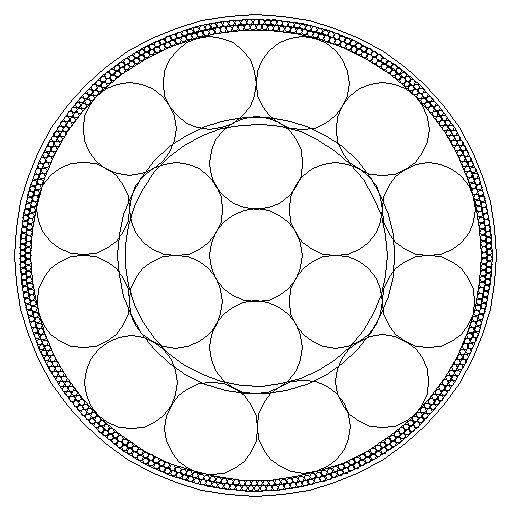
The layers of Earth allow space for a certain type of mantle convection process, called RB convection, where ‘R’ stands for Rayleigh and ‘B’ for Bénard. This type of convection should also be expected to occur within the Earth. RB convection has been studied quite intesively, and laboratory experiments with mantle material lead to the formation of convection rolls. It should be pointed out here that a section of RB convection rolls should have equal height and width.

If the RB convection rolls sections are inserted into the equatorial plane, this is the first result, as shown above. The equatorial plane has a double function, as it is both a plane of convection and rotation. When the convectional plane and rotational plane are one and the same, this simple picture emerges shown above. It fits perfectly, can be logically explained, and should therefore be studied further.
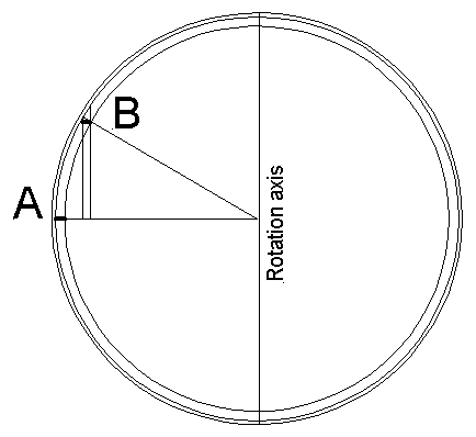
Then what happens when the rotational plane and convectional plane are separated? For us, what happens is that we have to deal with those two factors separately. The proportions, when considered from the side of physics of convection and rotation together, remain the same for different latitudes. This is shown here below:

A convection roll section is examined at latitude A and latitude B. Section A is at equator with equal height and width. B is at a higher latitude, which is shorter and the deapth is the same, so at first it seem disproportionate, but according to physics it still has the proportions of a section of equal height and width. The rotational part is not combined with the convectional part, but when comparing them and putting them together, it is obvious that the rules of RB convection apply at B in the same way as at A. We are not used to think about two separate things at one time, so we better take the trouble to take those two factors of convection and rotation and combine them graphically to be able to understand this. Thereby, we can see that RB convection is taking place at all latitudes, not only within the plane of equator.
The remaining analysis concentrates on the horizontal layout of the convection rolls. The horizontal part can be calculated, and therefore the location of the rolls of different layers is known and can be used to explain geological features all over the world.
The Mid-Ocean Ridge of Iceland – How Does it Work?
The division between the North American Tectonic Plate and Eurasian Tectonic Plate through Iceland can be seen on this map. The mid-ocean ridges have a rift valley on the top, clearly marking the division line. Iceland has volcanic zones instead, found farther east.

The main volcanic zones show some resemblance with the mid-ocean ridges. The eastern edge is parallel with the Reykjanes ridge, 1.5 degrees farther to the east for the West Volcanic Zone, and 4.5 degrees farther east for the East Volcanic Zone. The Öræfajökull Volcano is found 6 degrees farther east. On the map, the two ridges have been connected with a red line.
Iceland is located on an abyss, roughly elliptical, clearly seen on maps showing the depth of the ocean. Marking that elliptical form and comparing with the connection between the relevant mid-ocean ridges, the connection point between the ridges and the central point of the ellipse are found to be one and the same point.
Looking into the details of all the volcanic zones of Iceland, it becomes clear that they can be divided into relatively small polygonal areas, mainly diamond-shaped. These polygons are marked here, and it turns out that practically all the volcanic zones can be divided into two polygonal areas.
All of this is derived from one and the same analysis of convection rolls within the mantle, presuming that it behaves in the same way as it does when heated under pressure in laboratory environment. It has been found that convection rolls form under those circumstances, of equal hight and width. Making a model, inserting convection rolls into the mantle of the Earth, leads to these conclusions.
All the geological procedures, and the consequences described here, thereby become readily understandable. Here are hundreds of other posts showing various aspects of how the mantle affects the surface of the Earth. Each of them has some additional indications.
Why Convection Rolls of the Mantle Form a Regular Pattern
Convection rolls within the mantle have an adiabatic heat gradient, starting at the border between tectonic plate bottom and the layer below. Logically, the mantle must therefore as a whole be on the verge of being ductile and stagnant. A tectonic plate is 120 km thick, according to the defination that its lowermost border is where convection, or constant flow of mantle material, is found.
It has been found in laboratories, that if mantle material at this point (convecting but very close to becoming stagnant) does form convection rolls. As reality and experimental results are to be compared, especially if no other factors affecting real circumstances than used during experiment can be pointed out, inserting the outcome of experiment into known and measured circumstances is indeed a piece of work any scientist should undertake.
In this case it is easy, because the thickness of inner layers of Earth are known. Putting togherher the outcome of the experiments in laboratories, the logic of adiabadic thermal gradient, and knowledge about the depth of each layer, this is the outcome:

This is the basic picture of a section of convection rolls within the Earth. Inserting the results of experiments, fits exactly into measured environment.
Most people recognize the core, mantle and crust, and some might notice the Gutenberg layer, also known as the core-mantle boundary or CMB. This is a beginning of a study described in the book found here on this webpage. Reading that book is of course more difficult than reading this short post, and most people do certainly not have time enough to read it. It can be said here, though, that all the implications have been worked out, and how the convection rolls form a 3D system within the Earth is thereby fully understood. In turn, it enhances our overall understanding of geology.