By examining a relief map of Iceland, key geological features become far more apparent than they would otherwise. One such map is displayed in the lobby of the visitor center at Þingvellir.
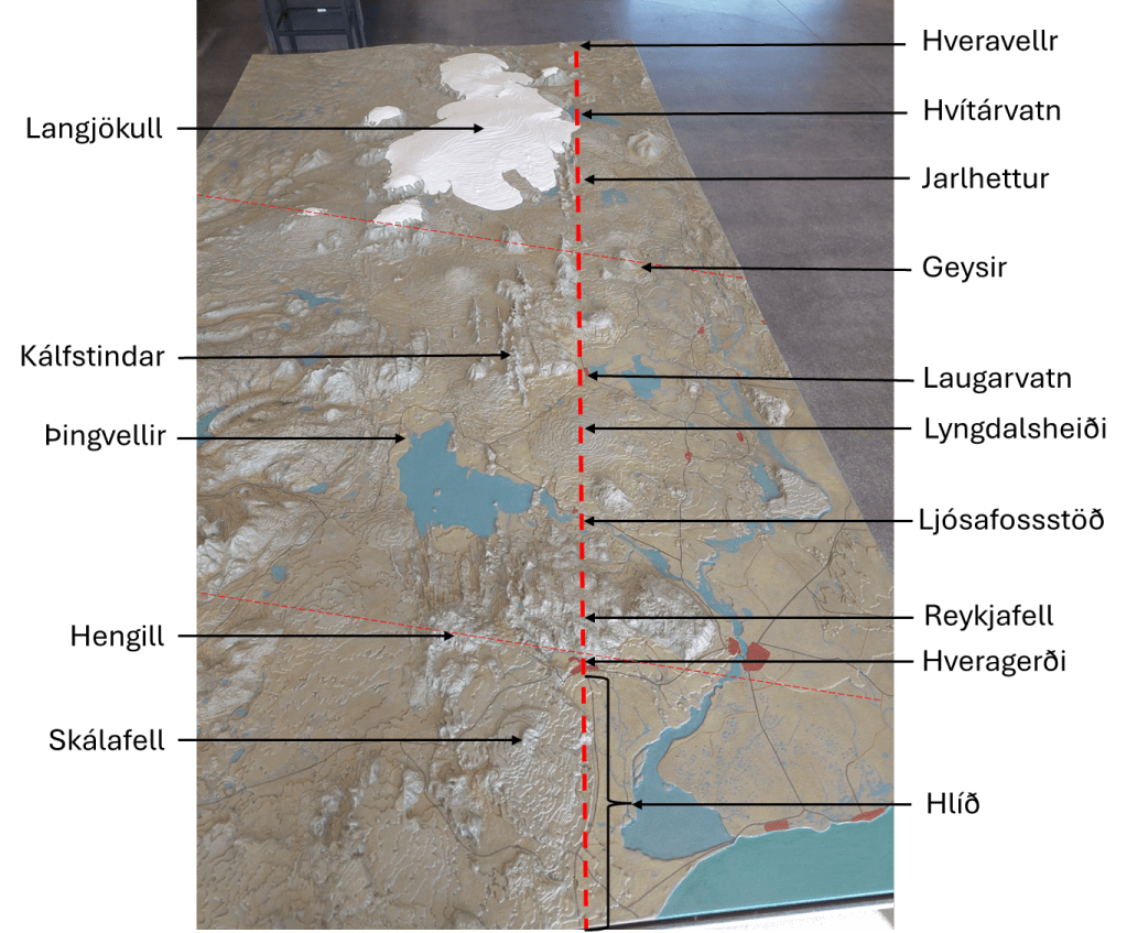
A broken red line has been drawn to delineate the boundary along the western margin of the Western Volcanic Zone. This boundary can be traced continuously from north to south across the landscape. At its northernmost extent lie Hveravellir, a significant high-temperature geothermal field situated in the central highlands. Immediately to the west is Langjökull, beneath which two volcanic systems are located. Proceeding southward, one encounters Hvítárvatn, a proglacial lake that serves as a major outlet for meltwater from Langjökull and lies directly on this geological boundary.
Further south, the Jarlhettur form a row of hyaloclastite ridges aligned along the same divisional trend. This boundary corresponds to the interface between two mantle convection rolls beneath the approximately 120 km thick lithospheric plate. In addition to this division, deeper convection rolls boundaries are present, above which lies the Geysir geothermal area.
South of this part, volcanic formations of a different character emerge, including Laugarvatnsfjall, located above the lake Laugarvatn, pointed out on the map. These formations extend westward to Kálfstindar at the side of the Þingvellir graben, which follows the same orientation as the main boundary shown here. The geothermal activity at Laugarvatn is well documented. Immediately south of Laugarvatn lies the shield volcano Lyngdalsheiði. The boundary intersects the summit crater Þrasaborgir.
Notably, the hydroelectric power stations along the Sog river are situated on this boundary, marking a transition from highland terrain to the west to lower elevations in the east. The former waterfall Ljósafoss was located precisely along this division. Further south lies the mountainous region associated with Hrómundartindur, of which Reykjafell, near Hveragerði, forms a part. Here, deeper boundaries between mantle convection rolls extend westward beneath the Hengill volcanic system. South of this area, sharply defined structural boundaries known as Hlíð appear. These correspond in practice to the eastern flank of the shield volcano Skálafell and associated volcanic formations along the eastern edge of the Western Volcanic Zone.
In this region, the mantle convection rolls rotate in opposite directions. The western side coincides with the West Volcanic Zone, where one convection roll resists the northwestward motion of the North American Plate. In contrast, the area to the east is transported along with the underlying mantle flow. Consequently, the western region is subjected to continuous extensional forces, resulting in crustal rifting. This process is most clearly expressed in the rift valley at Þingvellir.
