Blog

Uncategorized

The Geometry of the Pacific Ocean

Comparing large-scale convection rolls with the shape of the Pacific Ocean reveals several intriguing geometrical structures. The first step is to consider the equator itself. It forms a simple reference line, but one with important physical implications, because the effects of Earth’s rotation differ there from those at other latitudes. At the equator, the clockwise deflection characteristic of the Northern Hemisphere, and the tendency of horizontally moving particles to turn anticlockwise, do not apply in the same way.

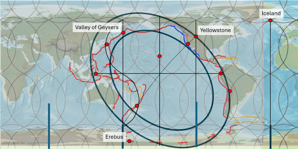
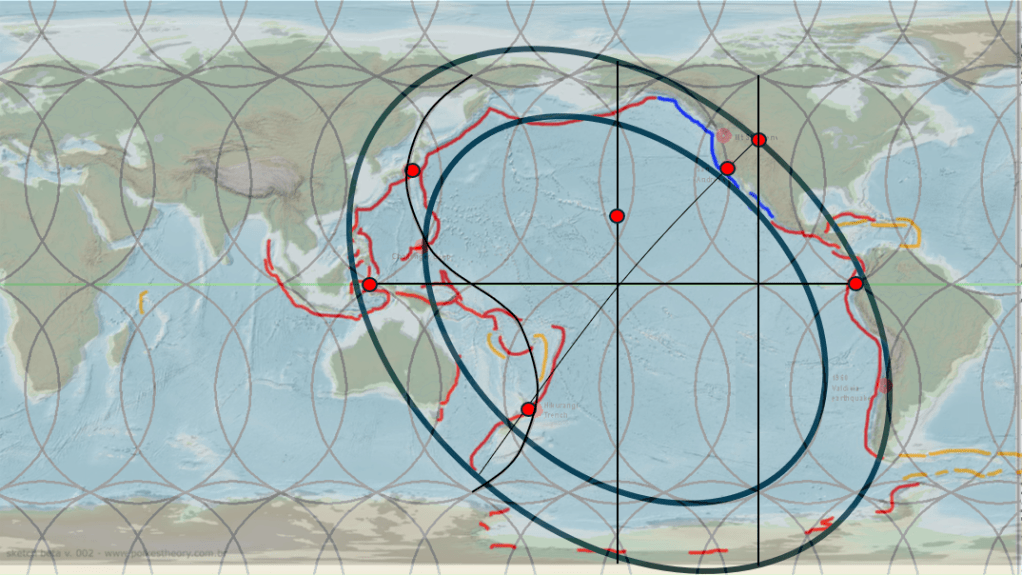
The Geometry of the Pacific Ocean.

The presence of major subduction zones on either side of the Pacific, Indonesia in the west and South America in the east, approximately 150° apart, provides two stable reference points.

As the Ring of Fire is a well-established concept, the volcanic regions can be outlined in a relatively simple way, beginning from these two equatorial reference points. The San Andreas Fault provides particularly strong support for this geometry, as it forms the sliding boundary between the Pacific Plate and the North American Plate. https://www.youtube.com/watch?v=YQtMBmS49Ew It thereby marks the approximate position of the minor axis of the elliptical form that appears when the Ring of Fire is sketched onto a map. This essay contains a lot of details:

Several principal lower-mantle division lines from the mantle convection rolls model are also drawn on the map. It should perhaps have been mentioned earlier that the major intersections between the main lower-mantle convection rolls coincide with the subduction regions on both the Indonesian and South American sides of the Pacific (shown with red dots). This observation alone deserves attention when comparing the model with the map.

Additional features emerge when examining the northeastern section of the Ring of Fire. When the outer limits of the Ring of Fire are outlined, the resulting elliptical form crosses Yellowstone National Park, a volcanic region unlike any other. Within the model, the pattern created by the division lines between convection rolls of different mantle layers produces a north–south axis between the predominantly north–south-trending rolls. Yellowstone is located directly on such a north–south axis.

With this in mind, the position of Hawaii also becomes significant. Hawaii is located not only on the north–south axis emerging from the convection-roll division pattern, but also on the central north–south axis of the Ring of Fire as represented on this map.

Looking at the western side of the Pacific, one of the first indications of a broader geometrical structure is the position of New Zealand along the minor axis of the elliptical form, opposite the San Andreas region and Yellowstone on the same axis. The Taupō Volcanic Zone is located where this minor axis intersects a principal lower-mantle division line. On the map, that mantle division line is drawn somewhat exaggerated in order to emphasize its significance.

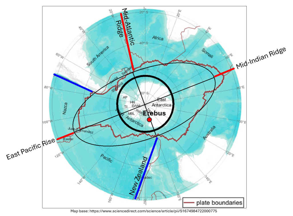
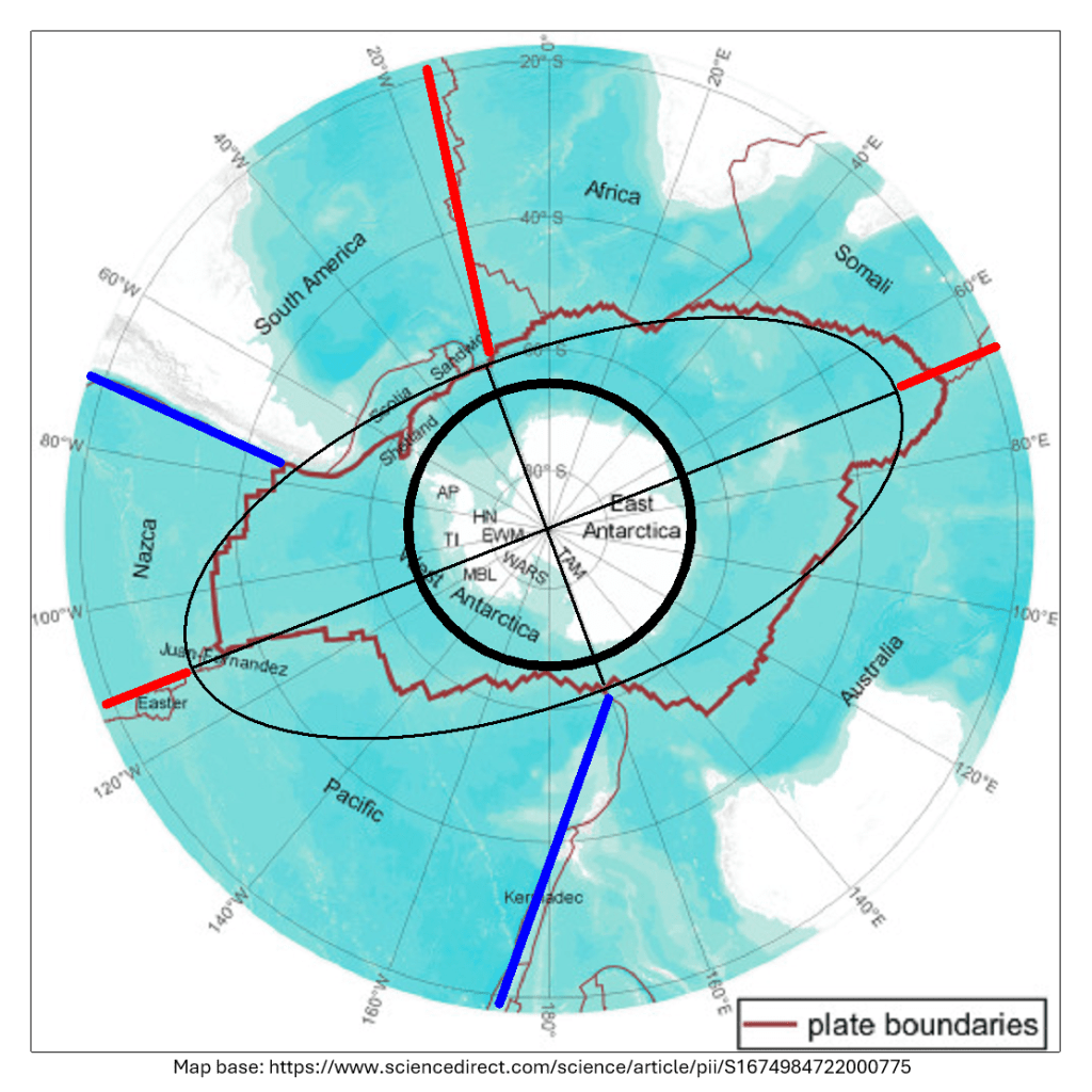
The western Pacific is subject to intense geophysical and tectonic stress, and this particular division line — extending from Japan to New Zealand — appears to accommodate much of that stress. Comparing the Northern and Southern Hemispheres, New Zealand and Japan, together with the subduction systems extending southward and northward from them respectively, display a mirrored relationship. Because stress is concentrated along this division line, and because rotational effects differ symmetrically between the hemispheres, New Zealand appears within the inner elliptical form of the Ring of Fire.

Further similarities emerge when examining the convection-roll division lines. Not only do Japan and New Zealand occupy corresponding positions within the model, but major volcanic centres such as Mount Fuji and Taupō are also found in analogous hemispherical settings on opposite sides of the globe. Likewise, the Kermadec Trench and the Izu–Bonin Trench display mirrored alignments.

The circular — or more precisely elliptical — geometry of the Pacific can therefore be compared with many details of the mantle convection rolls model. At the same time, the dimensions and shape of the Pacific have continually changed through tectonic drift. Over geological time, plate motion gradually alters the geometry of the basin itself.

The geological development of the region is equally revealing. Research has shown that much of the crustal material now forming southern Alaska originated at far more southern latitudes and has since been transported more than a thousand kilometres toward the northwest. The Denali Fault and Tintina Fault systems appear to have played a major role in this transport after island arcs had been sutured onto the North American continent. This partly illustrates how the Ring of Fire functions and why it extends across a geometrically well-defined region composed primarily of two concentric elliptical forms and the area enclosed within them.

This perspective also suggests that subduction zones may remain relatively fixed once established within the mantle convection rolls system. As the geometry evolves through tectonic drift, slabs descending into the mantle may become detached from their original surface plates, while new subduction zones eventually develop elsewhere.

It should be added here, tht there is a possible explanation for the formation of north–south axes within the framework of convection rolls. This becomes apparent when examining the detailed geometry of the division lines and polygonal regions formed between them. These polygons often tend toward a diamond-shaped geometry, with corners aligned approximately east–west and north–south.

Pressure exerted along the sides of such polygons may then create preferential lines of weakness or activity extending from one corner to the opposite corner. When this process is repeated across many adjacent small polygons, the resulting alignment can be extrapolated into the large-scale north–south patterns observed across the Pacific and elsewhere.

A particularly clear example of this type of geometry can be examined in Iceland. There, the North Volcanic Zone forms a pronounced north–south volcanic alignment, while the South Iceland Seismic Zone follows an east–west-oriented structural trend. Together, these systems illustrate how polygonal stress geometry within the mantle convection rolls framework may influence both volcanic and seismic alignments on the surface.

Uncategorized

The Central Role of Hekla Volcano

Hekla is known to occupy a uniquely important geological position within Iceland. It lies at the eastern end of the South Iceland Seismic Zone (SISZ) and simultaneously forms the southwestern gateway into the East Volcanic Zone (EVZ). In many ways, Hekla stands at the transition between two fundamentally different tectonic expressions: the transform-style seismic deformation of South Iceland and the broad volcanic rifting of the eastern volcanic systems.

The rifting process commonly described in Icelandic geology, where one side of Iceland drifts roughly 1 cm westward each year while the other moves about 1 cm eastward, can be visualized as being organized around a central tectonic division line that reaches the latitude and structural position of Hekla. This gives Hekla a particularly important geometric and tectonic role within the overall framework of Iceland.

The East Volcanic Zone is more difficult to represent with a single line than the oceanic ridges north and south of Iceland, because the EVZ is not a narrow ridge crest but rather a broad tectono-volcanic corridor 1.5° wide from east to west. In this interpretation, special emphasis is placed on the eastern boundary of the EVZ, which appears to function as a major division between tectonic domains associated with the North American and Eurasian plates. Rather than viewing the EVZ simply as a diffuse volcanic belt, it can therefore be examined as a structured rift system occupying a broad zone between deeper mantle flow divisions.

When zooming out to examine the large-scale geometry of Iceland itself, including the mid-ocean ridges and the surrounding continental shelf, an even more remarkable arrangement becomes visible, with Hekla occupying a central position within the overall symmetry.

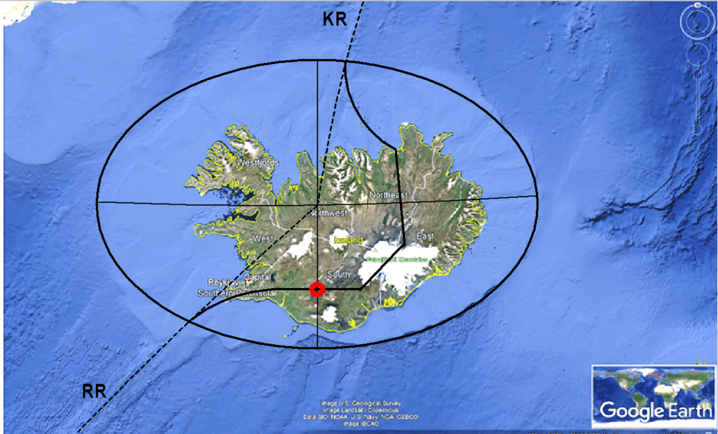
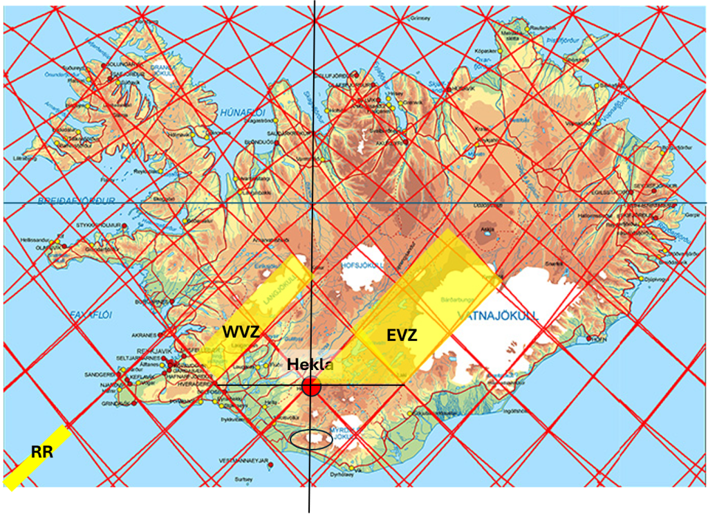
Location of Hekla (red circle) and the Elliptical Outline of the Continental Shelf of Iceland.

The continental shelf surrounding Iceland has a surprisingly regular form. The southeastern quarter of the shelf, in particular, remains relatively undisturbed and displays a sharp elliptical geometry that can be detected mathematically. The ellipse possesses clearly identifiable major and minor axes aligned directly east–west and north–south respectively. Significantly, Hekla is located on the north–south minor axis of this elliptical structure.

The N-S central axis.

If the major and minor axes of the Icelandic shelf ellipse are drawn, and the oceanic segments of the Reykjanes Ridge and Kolbeinsey Ridge are extended toward Iceland from the south and north, the two ridge extensions converge precisely in the central point of the ellipse itself (extrapolation shown with dotted lines). This creates a striking geometric relationship between:

  • the elliptical form of the Icelandic continental shelf,
  • the mid-ocean ridge system north and south of Iceland,
  • the tectonic division between the North American and Eurasian plates,
  • and the position of Hekla within the overall structure.
https://images.openai.com/static-rsc-4/f0-26YLRxhCiJe-Z8uX1Q2B7ceulF2OD7H-1f2yVrPH5odNHbqA4tI9Z60AV0DdbyQbG7U0xvQZqy8F5o3SFFts3s8l2aDaW7zROriGXKW_8bQwV4MMAjj4BZzGOvQavqSl9XDhOBwfYs9x2TPJwF0-AMJY-NMqUhZ_rI9iOXk9R2U2qgLRgWCi-sHkWsqZT?purpose=fullsize

The tectonic division line through Iceland also appears remarkably symmetrical when compared with both the elliptical outline of the shelf and the extended ridge axes. North and south of Iceland alike, the plate division lines merge naturally into the mid-ocean ridges exactly where those ridges intersect the elliptical margins of the shelf.

Within this broader framework, the detailed geometry of mantle convection-roll polygons and their division lines becomes increasingly important. The interaction between different mantle layers, tectonic boundaries, volcanic zones, and continental-shelf geometry may together help explain why Hekla occupies such an exceptional position within Icelandic geology.

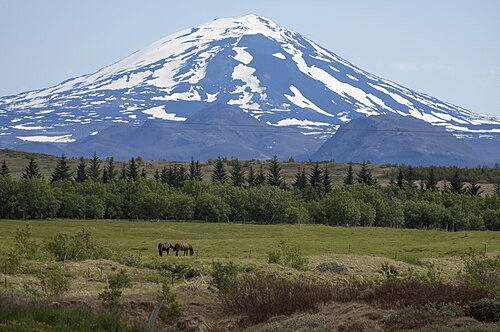
Location of Hekla.

Hekla has been regarded as Iceland’s most famous volcano for centuries, and perhaps not only because of its frequent eruptions and dramatic appearance. Its location suggests that it occupies one of the most structurally significant positions in the entire geological framework of Iceland.

Hekla
Uncategorized

The Three Corners of Vatnajökull

The largest glacier in Iceland, Vatnajökull, covers several major volcanic systems. Direct geological research beneath the glacier is difficult because of the extreme environmental conditions, thick ice cover, and active geothermal areas. Nevertheless, a remarkable amount is known about the volcanic framework beneath the ice.

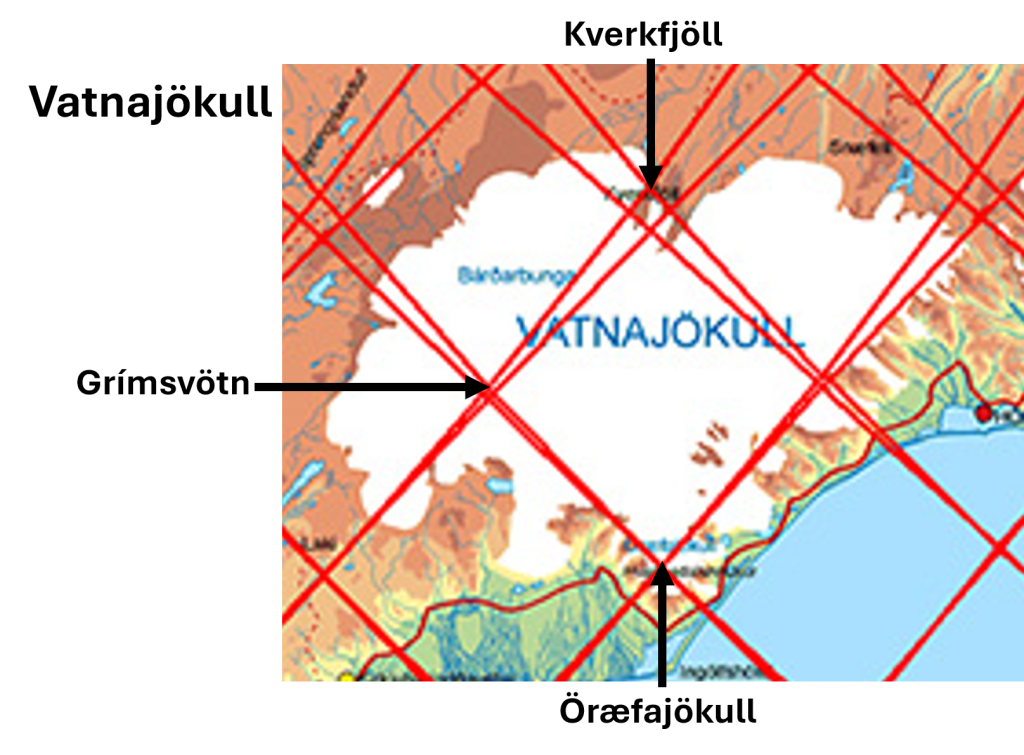
Vatnajökull with Öræfajökull, Grímsvötn and Kverkfjöll.

Three prominent volcanic regions are especially important in this context because they appear to fit clearly into the proposed pattern of mantle convection roll division lines.

The first is Öræfajökull, the tallest volcano in Iceland, situated close to the 64th parallel. The second is Grímsvötn, a vast but more obscure volcanic and geothermal complex beneath central Vatnajökull. The third is Kverkfjöll, which occupies a relatively small polygon directly north of Öræfajökull.

Kverkfjöll is particularly significant because it marks the southern starting point of the North Volcanic Zone. From there, a remarkably direct volcanic axis can be traced northward all the way to Öxarfjörður, where the North Volcanic Zone meets the Tjörnes Fracture Zone. This fracture zone, in turn, connects the volcanic systems of Iceland with the offshore Kolbeinsey Ridge.

The geometrical relationship between these three volcanic centers is striking. The polygon formed by Öræfajökull, Grímsvötn, and Kverkfjöll appears exceptionally clear within the proposed convection-roll framework. In addition, Grímsvötn and Kverkfjöll are known to be petrologically related, suggesting a deeper structural connection beneath Vatnajökull.

Grímsvötn was also the source region of the magma and dyke propagation that eventually produced the catastrophic Laki eruption in 1783. Within this framework, the magma migration becomes especially interesting because the dyke propagated from one calculated division line toward another before the eruption began. Laki itself lies on one division line, whereas Grímsvötn occupies another.

The line extending from Kverkfjöll through Grímsvötn to Laki closely coincides with the eastern boundary of the East Volcanic Zone. The width of this volcanic zone can be measured directly on the surface, and it corresponds closely to the calculated width of the relevant convection roll in the model.

On the opposite side of the Grímsvötn–Kverkfjöll line lies Öræfajökull, which also marks the beginning of another volcanic alignment: the Öræfajökull Flank Zone. This zone trends northeast–southwest and extends toward Snæfell northeast of Vatnajökull. In total, the flank zone spans approximately the equivalent of two polygons within the proposed geometrical framework.

The repeated appearance of the same fundamental geometrical unit — polygons with an approximate east–west width of 1.5° — is one of the main reasons the model may provide a valuable tool for examining geological structures. According to this interpretation, the same geometrical relationships are not confined to Iceland alone, but may also appear in tectonic and volcanic systems throughout the world.

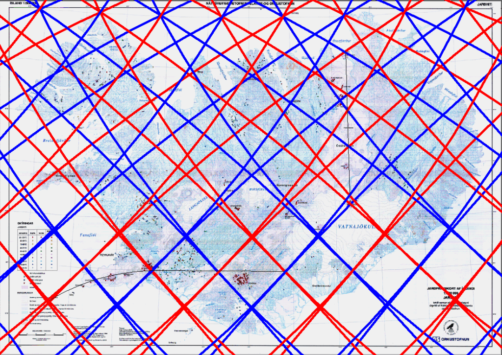
Geothermal areas of Iceland with superimposed mantle convection roll division lines and the tectonic boundary between the North American and Eurasian plates.

Within Iceland, however, Vatnajökull provides one of the clearest large-scale examples. Beneath the ice cap, some of the country’s most powerful volcanic systems appear organized in a pattern that mirrors the calculated geometry of the mantle convection roll model. Each polygon therefore becomes something like a chapter in a book, with each one containing its own distinct geological characteristics, tectonic structures, volcanic systems, geothermal activity, and landscape evolution.

Viewed in this way, Iceland can be examined as a sequence of interconnected geological “chapters,” where every polygon reveals a slightly different expression of the same underlying mantle convection roll system. One polygon may be dominated by rifting and fissure swarms, another by central volcanoes and geothermal fields, while a third may display transform faulting, glacial volcanoes, or complex magma interactions beneath ice caps.

This approach is valuable because it provides a structured way to examine geology step by step. Instead of viewing Icelandic geology as a collection of isolated volcanic systems, each region can be interpreted as part of a larger geometrical framework extending through the crust and into the mantle below.

The same method can also be applied to other parts of Iceland. The Reykjanes Peninsula, the South Iceland Seismic Zone, the Hengill area, the central highlands, and the northern volcanic systems all become individual “chapters” whose geological behaviour can be compared within the same overall framework.

In that sense, the polygon system is not only a geometrical model. It also becomes an organizational tool for understanding geology across many different scales — from magma migration beneath a glacier to the overall tectonic structure of Iceland itself.

Uncategorized

Comparing the three equatorial landmasses of South America, Africa, and Indonesia

Comparing the Equatorial Landmasses

Comparing the three equatorial landmasses of South America, Africa, and Indonesia, we should consider the geometry of these regions and the geological features that immediately stand out on a global map.

Starting with South America, the enormous Peru–Chile Trench forms the westernmost tectonic boundary of the continent. To the north lies the Caribbean region, partly encircled by another major subduction system. The easternmost point of this equatorial landmass is represented by the Amazon Estuary. The next diamond-shaped equatorial landmass, Africa, is located roughly 60° farther east. Its western margin lies along the Atlantic coast of Africa, while its eastern corner corresponds to the region of the Great Rift Valley, one of the most tectonically active continental structures on Earth. Looking farther east toward Indonesia, the western boundary lies near Sumatra, close to the site of the enormous eruption about 74,000 years ago, commonly associated with the largest caldera in the world of Lake Toba, which some researchers suggest almost wiped out early human populations. The eastern margin of this equatorial region lies within what is probably the most geologically complex area in the world, where multiple tectonic plates, island arcs, microcontinents, and subduction systems interact.

This regularity, both in the geometry of the landmasses and in the distribution of major geological structures, is intriguing. It corresponds remarkably well with the pattern predicted by modeled mantle convection rolls, based on laboratory studies showing that mantle material naturally tends to organize into elongated convection structures under conditions that can logically be expected within Earth’s interior.

From the perspective of the scientific method, this represents a prediction-and-observation type of correspondence. The large-scale surface geometry and tectonic structures visible on world maps are objective features that can be examined directly. The additional step taken here is to propose an explanation for why this pattern may have emerged. Laboratory experiments, the known layered structure of Earth, and mapped geological surface features can, in this interpretation, be viewed as parts of a single coherent framework. Within that framework, Iceland also fits naturally into the larger pattern, positioned between the equatorial regions of South America and Africa along the Mid-Atlantic Ridge. No advanced mathematics are required to recognize the broad geometric relationships visible on a world map. The spatial arrangement itself already suggests a striking degree of large-scale organization.

Hawaii, Iceland and Indonesian lines

The global pattern of the mantle convection roll system can be examined in many different ways. Focusing on the distribution of landmasses along the equator is particularly revealing, but the pattern also appears in other large-scale geological alignments. When tracing the regularity of the division lines, resembling those observed in Iceland, one can see that Hawaii is connected to the system farther west, while Indonesia aligns with the system farther east. These are observations on a planetary scale. Yet when the same framework is examined in greater detail, for example in Iceland, it also appears capable of explaining aspects of local geology.

The mantle convection rolls model is theoretical and is based primarily on seismic measurements from around the world, which reveal the layered internal structure of Earth. Nevertheless, the model becomes significant because its explanatory value extends far beyond what might initially be expected. Within this framework, the large-scale structure of the mantle can be anticipated by inserting convection rolls into the known layers of Earth’s interior. Because mantle motion is extremely slow, and no oscillation takes place, the horizontal alignment of the rolls can be calculated very accurately. In this interpretation, the geometry is controlled by convection itself, the spherical shape of Earth, and the fact that the planet rotates.

The proposed alignment of the convection rolls can then be compared with observable geological features at the surface. According to this interpretation, the boundary lines become identifiable in many locations around the world through tectonic, volcanic, geothermal, and topographic patterns. From this perspective, Iceland becomes especially important because it provides a relatively accessible surface expression of processes that may otherwise be difficult to recognize at a global scale. The combination of active rifting, volcanism, seismicity, geothermal systems, and clear tectonic boundaries allows the larger mantle framework to be examined in unusually fine detail.

Uncategorized

Indonesia’s Divide: Mantle Geometry Between Bali and Lombok

Indonesia is one of the most remarkable geological regions on Earth. Thousands of islands stretch across the equator between Asia and Australia, while some of the world’s most powerful volcanic systems rise above active subduction zones. Yet the geological structure of Indonesia is not random. Certain large-scale patterns appear repeatedly, and some of them may reflect deep convection geometry within Earth itself.

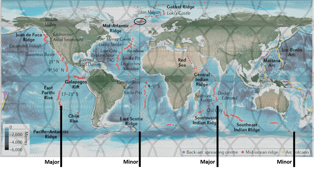
One of the clearest examples is found near the equator. The Indonesian subduction system contains major volcanic and tectonic segments spaced at surprisingly regular intervals. Particularly interesting are the great subduction arcs found 30° apart along the equatorial region. This large-scale spacing resembles geometrical organization rather than isolated local structures.

The deep channel between Bali and Lombok is not simply a surface feature. It coincides with a major tectonic and geological boundary zone. From the perspective of mantle convection geometry, this location represents a downwelling division line between adjacent convection rolls beneath the lithosphere.

https://images.openai.com/static-rsc-4/GdlPb5j_7Ogjq5KGKDyaL9h0isxZxo-Cs90XBDyUPwMHbxuAf9O1VGZMOLE7S7ahngtGIdptrdT7_qo2fCYrxXryLSddYhNtp2xDWILWAK8l9gKRlTjOzM5CxNd31yFrV36fzhJXscUj4uv-o31Xx-zTH5GvcuOo91sbEHj7MobT-czQMnEM7VClc1H0jyO5?purpose=fullsize
https://images.openai.com/static-rsc-4/gQ_LHrMi19-X9LybLDpET2fpr5xwAnpEkXv-BaTgWKbZt1uJ8N7S00xbOmPhuPRYnpaZSaaZ9p1fOq9nxI3lgFjbkQS6JlVCJboeGXN_9CcrspaS7Bfvd8qaeyll8VRlZUAxLeU7pI89bLy0AA6e4EIneDlwjMVDjf9JCWYQ-c0BnX2t4cocvJpEjWTHWXpp?purpose=fullsize
https://images.openai.com/static-rsc-4/hIbTrpCd4acRQ15NxNGTT-fY-j-sEd-gqd2U-lxbBf0uAQhNhJ0gGsh8BM6bBHVba6mcAmqesa45BJucB0ErOdCyWhDmxNBishkr5DLjHS5kDinlLrReGRyoProDv3ib5LQTaZxUe4UVKk0MDplxoTg3QOiwCHRDPKbybgkLFsvdkv0UBlK7ciB4twjc3nBA?purpose=fullsize

The Wallace Line

The naturalist Alfred Russel Wallace observed during the nineteenth century that an extraordinary biological boundary exists between Bali and Lombok.

West of the line, Asian flora and fauna dominate. Monkeys, woodpeckers, and many placental mammals are characteristic. East of the line, Australian affinities begin to appear. Cockatoos and other species linked to Australia become increasingly common farther east.

This boundary became known as the Wallace Line. What makes this especially remarkable is the geography itself. Bali and Lombok are very close together. At first sight one might expect that during Ice Age sea-level lowering the two islands would have been connected by dry land. But they never were, and the reason is that the strait between them is unusually deep. Even when sea level fell more than 100 meters during glacial periods, deep water remained between the islands. This preserved the biological separation over very long periods of time.

Deep Water and Downwelling

Division lines of the framework of the convection rolls model are of course both downwelling and upwelling. Sometimes the different effect of downwelling and upwelling becomes apparent, as downwelling zones may produce long-lived subsidence and deep marine corridors.

The Bali–Lombok Strait therefore becomes more than a biological curiosity. It may represent a surface expression of deep mantle organization.

The geometry is especially interesting because the downwelling line is parallel to a major lower-mantle upwelling division of the lower mantle (see cross section above). In this interpretation, the deep Earth structure controls not only volcanic belts, but also long-term oceanic depth patterns.

Geological Contrast Between Bali and Lombok

The difference between the two islands is therfore first and foremost to be traced to geophysics.

https://images.openai.com/static-rsc-4/eLNRzBD2E-YGQO8Te9YwUd_jy1uDa5z8EgFBTePdwBLO_Vw1P8Vt7FIuhoTZhdkypDpQxo8WwIk4O2gcQHnVfpoCsLlxp56oWV3LFLQMm4rqqk1hNLsQmHlutd4sUJJVjQOvwoGkl8C3LW0K3vF_9NtqiwLyM0MXaaRAgO0tmpfVVKCT_Wbs4th-YK2g2JlT?purpose=fullsize
https://images.openai.com/static-rsc-4/FPt3EcUtp57zB8bYGgRVl3RRZSBsd2b7kYqgoQ5wA2JcjhU4t9zMSTpErFCH_FwFt-tKk1-cx50QlbudJXCim-fHThb4e-zg38-YW5eJbDo-0qfyTGg9QUseA6BuZijsCoeksCzAUSxspmu6RNusHGlrR2ddavPdOF-gFAUTGD9YbtgfUzwHgrAbTPjW-v3F?purpose=fullsize
https://images.openai.com/static-rsc-4/L79n7OU4J8p0hCC9jS1hCY3ZWC8jtYN2NzEk80nl6xvalN8k-EmTwzKqt1d_nHvMxc_dXSWPcK8Wq2jsNWydmEjyVxtTKCuMmdQXsFqK_or_wlZ6PfdaKeaYvbJ0HHMgH4fD1qfwyH34iU_tt5wDJ7M_Md126AB-jdER59rNXBUZBsdPrJkYZ1K5aQhmso9N?purpose=fullsize

Mount Agung on Bali and Mount Rinjani on Lombok belong to the same general volcanic arc system, yet the geological environment changes noticeably eastward toward the Banda Arc transition.

Lombok also contains the remains of the gigantic 1257 eruption of Mount Samalas, one of the largest eruptions of the last two millennia.

Eastward from Lombok tectonic complexity increases, crustal deformation becomes stronger, and the Indonesian arc system begins bending toward the Banda Sea region.

Thus the Wallace Line coincides with biological change, bathymetric change, tectonic change, volcanic change, and of course mantle-flow geometry of the convection rolls model itself.

Inner Earth and Surface Evolution

The Bali–Lombok division demonstrates how deeply Earth’s internal structure may influence the surface environment. The persistent deep-water boundary prevented land bridges to form when water was trapped in large glaciers of the ice age and separated the ecosystems,

In this interpretation, the contrast between Asian and Australian realms did not arise merely from chance migration patterns or sea-level fluctuations. Instead, the geometry of mantle convection itself may have maintained the separation over geological time.

The result is one of the clearest examples on Earth where deep mantle structure, as derived from the convection rolls model, coincides with tectonics, in this case ocean depth, volcanism and biological evolution

How Wallacea, and its division, coincides with the mantle convection rolls framework.

It all appears to be interconnected within the same regional framework. https://en.wikipedia.org/wiki/Wallacea