The influence of mantle convection upon the Earth’s surface can be examined through the tectonic patterns that develop above it. In this study, several recurring geometrical expressions are considered. First are the division lines between convection rolls. Second are the polygonal regions enclosed by those division lines, where geological structures frequently develop from one corner of a polygon to another, commonly in north–south or east–west directions. A third recurring expression is the appearance of elliptical forms under certain large-scale conditions.
These observations suggest that many aspects of geology may be investigated through geometric analysis. Once geometric consistency is identified, detailed geographic and geoscientific data can be used to further evaluate the resulting patterns and their possible physical significance.
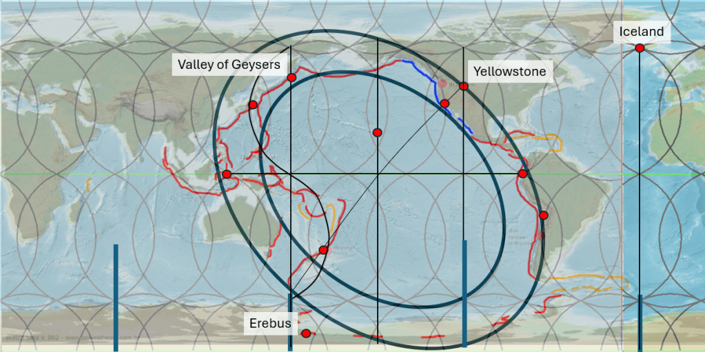
The Pacific Ring of Fire provides an important example. Although the exact physical processes governing its overall geometry remain uncertain, the arrangement itself displays remarkable large-scale regularity. Antarctica presents a similar challenge. Its tectonic framework is difficult to explain in simple terms, yet its geometry also appears highly organized.
Antarctica is particularly difficult to examine because most world maps distort the continent, stretching it along the southern edge of the map projection. When viewed directly from above the South Pole, however, its remarkably circular form becomes evident. It is also well known that Antarctica can be divided into East and West Antarctica, with the western sector being considerably more tectonically and volcanically active.
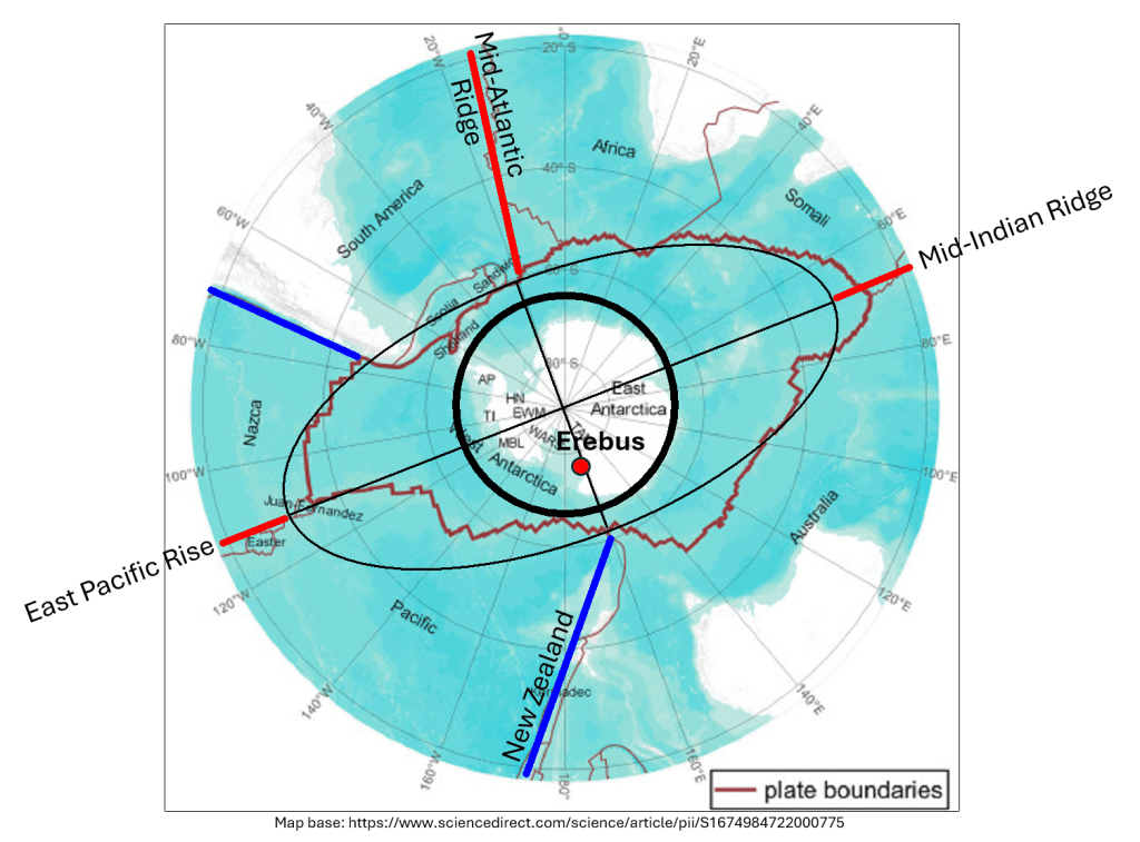
The boundary between East and West Antarctica appears to coincide closely with the center of the minor axis of the system of mid-ocean ridges encircling the continent. Near this axis lies the famous volcano Mount Erebus, one of the most persistently active volcanoes on Earth. Because Erebus is located at approximately 77.5°S latitude, its distance from the inferred minor axis is only about 100 km.
Another important geometric relationship emerges offshore from Erebus. At this location, the minor axis of the Antarctic system appears to intersect the minor axis of the Pacific Ring of Fire. Thus, the most active volcano in Antarctica occupies a position where two large-scale tectonic geometries appear to converge: the minor axis of the Antarctic ring of mid-ocean ridges and the minor axis of the Ring of Fire.
This geometric axis can then be examined further in relation to external geological conditions. When the Antarctic minor axis is extrapolated northward, it intersects the inner margin of the Ring of Fire at the location of the Valley of Geysers on the Kamchatka Peninsula. A similar relationship appears when extending the major axis of Antarctica northward toward the East Pacific Rise, where the projected line crosses the region of Yellowstone National Park, also situated at the geometrical margin of the Ring of Fire.
These two regions, Kamchatka and Yellowstone, contain by far the greatest concentration of geysers on Earth. Beyond them, only a few additional major geyser regions exist worldwide, and these too may potentially be interpreted within a similar geometric framework, such as Iceland. New Zealand is another obvious example.
The implication is not necessarily that geometry alone explains tectonic activity, but rather that persistent mantle organization may leave detectable large-scale geometric expressions at the Earth’s surface. Such relationships may provide an additional tool for examining the long-term structure of mantle convection and its connection to volcanism, tectonics, and geothermal activity. The degree of accuracy is very high, only to be understood in context with the mathematics of the shape of the Earth.
For more details: https://pangea.stanford.edu/ERE/db/GeoConf/papers/SGW/2024/Thorbjarnarson.pdf
