I am a geologist, graduated from the University of Iceland, and taught geology for a few years. I have gained some knowledge about Earth's inner structure, so I provide this website as my contribution to answer one of the greatest questions remaining within the realm of geoscience. Experiments show that the mantle should form convection rolls when close to the melting point. I took this literally, and calculated the dimensions and shape of these mantle convection rolls. Then I compare that model with the surface. This makes it possible to provide many interesting examples about geology found on my blog.
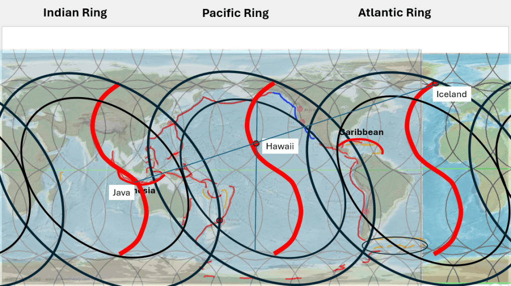
Occasionally, geographical coincidences appear that are interesting even though they have no particular scientific significance. One such example emerges when three well-known volcanic regions of Iceland, Hawaii and Java, are viewed in the context of the proposed convection-roll system.
Within this model, the volcanism of all three regions is related to the regular organization of mantle convection, although each occupies a different position within the system. Iceland lies near the northern end of a curved structure extending from the equatorial region, whereas Hawaii is situated closer to the middle of a comparable curve. Hawaii also lies approximately along the central axis of the Pacific tectonic ring, associated in this model with the Pacific Ring of Fire.
Farther west, Java provides the third element. In the proposed framework, one of the principal mantle divisions passes through this region and is associated with another major zone of mantle upwelling. The three principal mantle regions considered here are, in turn, associated with the central parts of the three large tectonic-ring systems: the Atlantic, Pacific and Indian Ocean rings.
There is also a purely cartographic curiosity. On a simple equirectangular world map, Iceland, Hawaii and Java can be placed approximately along a single straight line. The alignment is not exact and depends on the map projection and on which point within each island or island group is chosen. It is therefore not presented as scientific evidence or as part of the argument for the model. It is simply an intriguing geographical coincidence linking three of the world’s best-known volcanic regions.
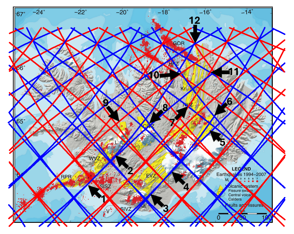
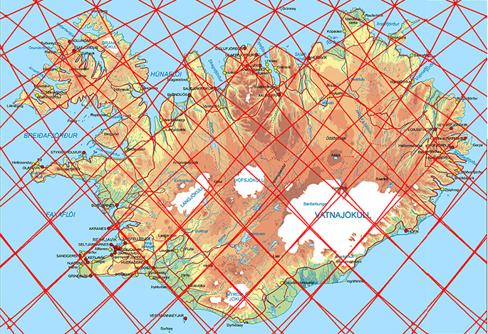
One of the most striking features of the convection-roll model is the degree of spatial correspondence between the predicted roll boundaries and the observed volcanic zones of Iceland. This correspondence is not restricted to a single volcanic zone or to a few isolated localities. It is repeated in the positions of volcanic-zone margins, changes in direction, intersections, volcanic centres, and the polygonal areas enclosed by the modelled boundaries.
The principal volcanic zones used for comparison are the Western Volcanic Zone (WVZ), Eastern Volcanic Zone (EVZ), Northern Volcanic Zone (NVZ), the Reykjanes volcanic zone, and the volcanic belt crossing Central Iceland. These are well-established components of the Icelandic volcanic and plate-boundary system, although different terminology has been used for the Central Iceland connection between the main rift zones.
Specific examples of correspondence
Spatial Correspondence Between the Convection-Roll Model and the Volcanic Zones of Iceland.
A number of locations are particularly useful for illustrating the geometrical precision of the correspondence shown on the map:
The Reykjanes volcanic zone south of Hveragerði. Here, one of the modelled boundaries coincides closely with the transition towards the South Iceland Seismic Zone (SISZ). The relationship is particularly informative because the SISZ forms the tectonic connection between the western and eastern rift systems of South Iceland.
The Western Volcanic Zone and Langjökull. A modelled roll boundary closely follows the margin of the volcanic zone in the Langjökull area. The spatial relationship is sufficiently sharp to make this an important reference point when the model is compared with mapped volcanic systems.
The Eastern Volcanic Zone north of Mýrdalsjökull. Another model boundary corresponds to the margin of the EVZ immediately north of the Mýrdalsjökull–Katla region.
The Vatnajökull boundary and Grímsvötn. Within the Vatnajökull region, a major boundary in the convection-roll pattern passes through the area of Grímsvötn, one of the principal volcanic centres of the EVZ.
The boundary extending northeastwards from Kverkfjöll. From the Kverkfjöll region, the mapped volcanic structures and the modelled roll boundary follow the same general northeastward direction.
The outer boundary of the Kverkfjöll volcanic system. The extent of the Kverkfjöll system provides another example in which the margin of a volcanic system corresponds to a boundary in the convection-roll pattern.
Internal boundaries within the Northern Volcanic Zone. The correspondence is not restricted to the outer margins of the NVZ. Several internal divisions within the volcanic zone also coincide with modelled roll boundaries.
The northwestward bend of the Central Iceland volcanic belt. The Central Iceland Volcanic Zone, as defined here, bends towards the northwest in a manner that follows the geometry of the convection-roll pattern.
A comparable bend in the Western Volcanic Zone. The WVZ displays a related change in orientation, extending towards another boundary in the modelled system.
10–11. The polygon occupied by the Northern Volcanic Zone. A particularly clear geometrical relationship occurs in North Iceland, where the volcanic systems of the NVZ occupy a polygonal sector approximately 1.5° in longitudinal width. Both sides of this sector are defined by boundaries in the convection-roll system.
The northern intersection point. The northernmost point highlighted on the map coincides with an intersection of two boundaries in the convection-roll framework. This is significant because intersections represent geometrically more restrictive predictions than correspondence with a single line.
The Eastern Volcanic Zone
The most continuous correspondence on the map occurs along the Eastern Volcanic Zone (EVZ).
Four large polygonal sectors of the convection-roll framework are occupied by the volcanic systems shown in yellow on the map. Rather than simply following a single line, the volcanic zone repeatedly fills the areas enclosed by successive boundaries.
The relationship also places several major volcanic centres and systems—including Hekla, Tindfjöll, Eyjafjallajökull, Katla beneath Mýrdalsjökull, and the Vestmannaeyjar volcanic system—within the same geometrical arrangement.
This is important because the comparison therefore involves several different geometrical properties simultaneously: boundaries, intersections, enclosed areas, changes in orientation, and the positions of individual volcanic centres.
The Western Volcanic Zone
Immediately west of the EVZ, the eastern margin of the Western Volcanic Zone (WVZ) is particularly distinct.
In the convection-roll framework, this boundary occurs approximately 3° west of the corresponding eastern boundary of the EVZ. Thus the two volcanic zones are not treated as unrelated features. They occupy neighbouring parts of the same regularly spaced geometrical system.
The WVZ also changes orientation towards its northern end, and this curvature can be compared with the orientation of the modelled roll boundaries.
Central Iceland
The Central Iceland volcanic belt shows a somewhat different type of correspondence.
Here the most prominent geometrical control is not simply a volcanic zone centred on a modelled line. Instead, one of the sharpest boundaries of the volcanic area corresponds to a downwelling boundary extending northeastwards from the region.
This distinction may be important. If upwelling and downwelling boundaries have different mechanical effects on the lithosphere, volcanic zones should not necessarily occupy identical positions relative to each type of boundary.
The Northern Volcanic Zone
The Northern Volcanic Zone (NVZ) provides another particularly clear example.
Its principal volcanic systems are arranged along a predominantly north–south to NNE–SSW axis, while their outer limits correspond to polygonal boundaries in the convection-roll framework. Independent geological studies also show that the NVZ consists of several overlapping volcanic systems and fissure swarms, including Kverkfjöll, Askja, Fremrinámur, Krafla and Þeistareykir.
In the present model, both upwelling and downwelling lines appear to contribute to the geometry of the volcanic zone. The correspondence therefore concerns not merely the central axis of volcanism but also its width and internal subdivision.
Features not fully visible on the map
The map does not show all the relationships that can potentially be tested.
Among the additional examples are the position of Öræfajökull, the geometrical relationship between Snæfellsjökull and Snæfell, and the former Skagafjörður volcanic zone.
The Skagafjörður system is particularly interesting in this context because its position is approximately 3° west of the Northern Volcanic Zone in the geometrical framework used here. Older rift structures in the Skagi region are independently recognised in geological studies of Iceland.
The offshore continuation provides further constraints. The orientations and positions of both the Reykjanes Ridge and the Kolbeinsey Ridge can be compared with the same convection-roll geometry. The Icelandic volcanic zones therefore form only the subaerial part of a considerably larger geometrical pattern.
Plate motion and the orientation of the roll boundaries
The two-dimensional geometrical correspondence is only part of the problem. The system must ultimately be interpreted in three dimensions because the lines on the map represent boundaries associated with several superimposed levels of convection rolls.
Plate motion must also be incorporated.
In the interpretation proposed here, the motion of the North American Plate away from the spreading system produces a major westward to northwestward extensional component across Iceland. This regional movement interacts with the directions of rotation of the underlying convection rolls.
This provides a possible explanation for an important feature of the map: the eastern margins of several volcanic zones are commonly associated with the blue boundaries of the model.
In the convection-roll interpretation, the roll adjacent to such a boundary rotates in a direction opposite to the motion imposed from the North American side. The opposing motions would increase differential movement across the boundary and could therefore favour extension of the overlying lithosphere.
A comparable relationship can be seen along the eastern side of the Northern Volcanic Zone, where several of the principal extensional structures are again bounded on their eastern side by blue lines.
This proposed relationship between plate motion, roll rotation and surface extension is important because it introduces a dynamic component into what would otherwise be only a geometrical comparison.
From geometrical correspondence to a testable model
The significance of the pattern lies in its repetition.
No single coincidence between a volcanic centre and a modelled boundary would provide strong evidence for a relationship. The more relevant observation is that similar relationships recur independently at the margins of several volcanic zones, at changes in their direction, at volcanic centres, at intersections, and within polygonal sectors of the model.
The Eastern Volcanic Zone is especially informative because the correspondence is repeated through several consecutive polygons rather than occurring at only one locality.
The Icelandic pattern can therefore be tested at several levels:
the distance between mapped volcanic-zone margins and predicted roll boundaries;
the angular agreement between volcanic structures and the modelled lines;
the positions of volcanic centres relative to predicted intersections;
the width of volcanic zones relative to the predicted polygonal cells;
the relationship between active and extinct volcanic zones and successive boundaries in the model;
and the relationship between the direction of plate motion and the inferred rotation of individual convection rolls.
Such tests would allow the apparent correspondence to be expressed quantitatively rather than only visually.
The important point is therefore not simply that volcanic activity occurs near individual lines. It is that the geometry of the Icelandic volcanic zones repeatedly reproduces several different elements of the proposed convection-roll framework—lines, margins, bends, intersections and enclosed polygons—at a range of locations across Iceland.
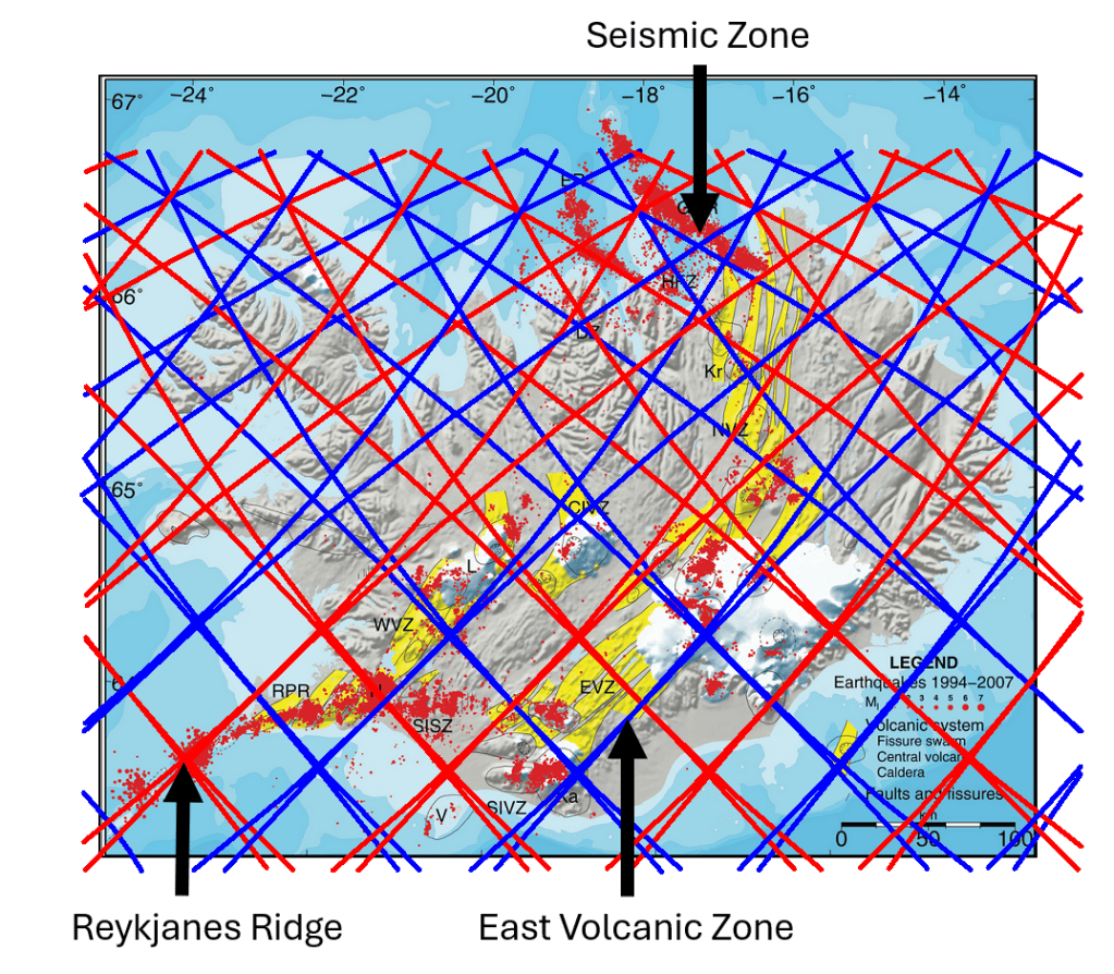
When considering the spreading of Iceland and the boundary between the North American and Eurasian plates, three main types of tectonic boundaries or structures need to be taken into account. These are, first, mid-ocean ridges; second, volcanic zones; and third, seismic zones. Within the convection-roll model, all of these follow lines that can be constructed on a map on the basis of the geometrical analysis of the convection rolls.
Reykjanes Ridge, East Volcanic Zone and Tjörnes Fracture Zone.
The convection-roll system follows a simple mathematical pattern, with each depth layer having its own set of convection rolls. In Iceland, however, the situation is more complex than in many other regions because the convection rolls of the polar system and the equatorial system meet and interact there. The correspondence is clearly visible on the map. The Reykjanes Ridge, for example, follows convection-roll divisions associated with the 120 km level over a considerable distance.
Main Upper Layers.
In southern Iceland, the situation is further complicated by the fact that division lines belonging to convection rolls at different depths often lie very close to one another, so that they may appear almost as a single line. A precise description of the boundaries shown on the map is therefore considerably more complex than the simplified interpretation presented here. The depth levels are used primarily as convenient reference levels.
As can be seen, the comparison can be extended across the whole of Iceland, revealing correspondences between the calculated lines and geological structures. Blue downwelling lines reproduce the eastern boundaries of both the Eastern Volcanic Zone and the Western Volcanic Zone with considerable precision. The geometry also shows that the two volcanic zones are separated by approximately 3°.
A similar relationship occurs in the Tjörnes Fracture Zone in northern Iceland. There, two principal seismic source lines correspond to adjacent convection-roll division lines separated by 1.5°. As more geological information is incorporated into the comparison, an increasing number of features can be tested against, and found to correspond with, this convection-roll framework.
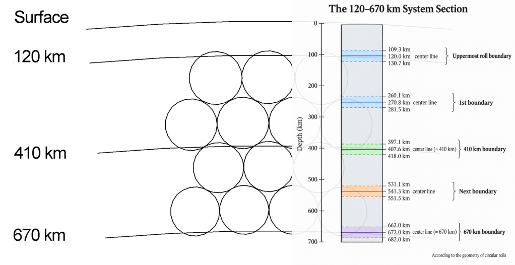
To compare these lines with the 120–670 km System Section, each mapped line can be related to the boundary of a particular depth interval. The section illustrated here applies to regions south of 60.7°N and also north of 67.3°N. Within the intervening latitude range, the geometry is considerably more complex: the number of layers effectively doubles, while their thicknesses vary with latitude. Nevertheless, the basic division is retained, and each layer can still be followed mathematically, allowing the boundaries of the convection rolls to be constructed with precision.
The polar system takes over progressively from the equatorial system and is superimposed upon it. At 64°N, however, the two systems act in combination, and the convection rolls of the two systems are aligned directly above one another. North and south of this latitude, the corresponding rolls gradually diverge from one another. Farther north, the polar system becomes increasingly dominant.
It is particularly noteworthy that the principal seismic zones—the Tjörnes Fracture Zone and the South Iceland Seismic Zone—are associated with different convection-roll division lines from those followed by the Reykjanes Ridge and the volcanic zones. These seismic-zone divisions are related to deeper parts of the system, specifically to the convection rolls immediately above the 410 km boundary. The same geometrical pattern is then repeated between the 410 km and 670 km depth levels.
Iceland provides an unusually detailed example of the relationship between surface tectonic structures and the proposed mantle convection-roll division system.
Convection Rolls System Division Lines of Iceland.
On the scale of the major oceanic plates, the convection-roll geometry can be compared with long plate boundaries, mid-ocean ridges and the elliptical tectonic rings. In Iceland, however, the same framework can be examined at much higher resolution. Volcanic zones, individual volcanic systems, fracture zones and even smaller polygonal structures can be compared directly with calculated mantle-division lines.
Four different types of correspondence are particularly useful.
1. Volcanic zones — the Eastern Volcanic Zone
One of the clearest examples is the Eastern Volcanic Zone of Iceland.
Its general orientation corresponds closely to the calculated direction of the convection-roll system beneath Iceland. Rather than treating the volcanic zone simply as an irregular surface continuation of plate spreading, the convection-roll model provides an underlying geometrical direction against which the zone can be compared.
This is important because the mantle divisions do not everywhere trend directly north–south. Their calculated orientation varies systematically with latitude. Iceland therefore provides a particularly useful test: the direction of the volcanic structures can be compared with a direction calculated independently from the convection-roll geometry.
The Eastern Volcanic Zone represents the first level of correspondence:
In other words, the model can be tested against the orientation of an entire volcanic belt.
2. Intersection points — Hekla
A second type of relationship occurs at intersections between calculated structural lines.
Hekla provides an important example.
Its position is associated not merely with the direction of one convection-roll division, but with a location where different geometrical elements of the system intersect. Such intersection points are potentially more important than individual lines because they represent places where different components of the underlying geometrical framework act together.
This provides a second level of correspondence:
Hekla is therefore useful not simply because it is a major volcano, but because its location can be examined in relation to a predicted geometrical crossing point. This may also help explain why some locations within a volcanic zone become much more prominent than others. A volcanic belt defines a broader structural corridor, while intersections may define particularly favourable locations within that corridor.
3. Polygonal structures, the South Iceland polygon
A third expression of the system appears when the calculated division lines are combined to form polygonal structures. South Iceland provides one of the clearest examples.
Here the relevant convection-roll divisions do not produce only isolated N–S or E–W lines. Their interaction defines a larger geometrical framework within which the tectonic structures of South Iceland can be analysed.
The South Iceland polygon is particularly important because it shows that the model is not restricted to matching the orientation of individual faults or volcanic zones. The intersections and connecting lines form a larger geometrical unit.
The relationship can therefore be written:
Within such a framework, individual fracture zones, volcanic systems and changes in structural orientation can occupy different sides, corners or internal divisions of the polygon.
This is also important for understanding the South Iceland Seismic Zone. The surface deformation need not reproduce the deeper geometrical framework as one continuous fault. Instead, the larger stress field can be accommodated through numerous smaller faults and fracture systems.
Thus, a relatively simple underlying geometry may produce a considerably more complex surface expression.
4. Linear boundaries — the Tjörnes Fracture Zone
The Tjörnes Fracture Zone provides a fourth type of comparison. Here the relationship is expressed through comparatively long tectonic lines and changes in direction that can be compared directly with the calculated convection-roll divisions. This differs from Hekla, where the emphasis is on an intersection, and from South Iceland, where the emphasis is on a polygonal framework.
The Tjörnes system illustrates the more direct relationship:
The fracture zone therefore provides another independent way of testing the model. A calculated mantle division can be compared not only with volcanic structures but also with a major transform and fracture-zone system.
Four expressions of the same underlying geometry
Taken together, these examples are particularly useful because they are not repetitions of the same type of observation. They represent four different geometrical relationships:
Volcanic-zone alignment — Eastern Volcanic Zone
Intersection point — Hekla
Polygonal framework — South Iceland
Linear tectonic structure — Tjörnes Fracture Zone
The significance of Iceland is therefore not based on one volcanic zone or one particularly favourable line. The same calculated framework appears to correspond to different types of geological structures at different scales.
The sequence can be summarized as:
This is one reason why Iceland has been so important in the development of the convection-roll model. The geological structures are sufficiently detailed to allow relationships to be examined on a much smaller scale than is possible around most major oceanic plates.
From Iceland to the global system
Iceland can therefore be regarded as a high-resolution calibration area for the larger geometrical framework. The same principles that can be examined locally in Iceland—directional divisions, intersections, polygonal structures and transitions between structural lines—can subsequently be investigated on the scale of entire tectonic plates.
This creates an important connection between the Icelandic examples and the analyses of the African, Somali and Nazca plates: In Iceland, the convection-roll framework can be examined at high resolution through volcanic zones, intersection points, polygons and fracture zones. On the scale of the major plates, the same geometrical principles appear as long plate boundaries and their interaction with the larger tectonic-ring system.
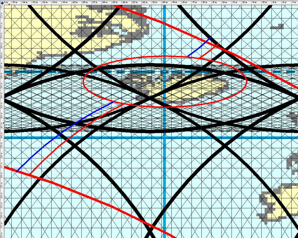
The tectonic structure surrounding Iceland can be viewed as the interaction of four related but distinct components. These are: (1) the mantle convection-roll system and its regularly spaced flow lines, (2) the overlap zone between the equatorial and polar parts of that system, expressed particularly through the Greenland–Iceland–Faroe Ridge Complex, (3) the large tectonic ellipse surrounding the Icelandic shelf, and (4) the active ridge–transform–volcanic-zone system that transfers plate separation through Iceland.
The continuity of the mid-ocean ridges – Reykjanes Ridge and Kolbeinsey Ridge.
These components should not be regarded as different descriptions of the same structure. Each appears to have a different geometrical and tectonic function. The convection-roll system defines large-scale mantle-flow trajectories; the overlap zone creates a special structural domain around Iceland; the tectonic ellipse appears to delimit a region in which ridge behaviour changes; and the active volcanic and transform zones accommodate the actual plate separation through Iceland.
Taken together, these four elements provide a coherent geometrical framework for the unusually complex tectonics of Iceland and its surrounding oceanic ridges.
The mid-ocean ridges and the tectonic ring framework, compared with the convection-roll system and the elliptical form of the Icelandic Plateau.
1. The Mantle Convection-Roll Framework
In the convection-roll model, tectonic structures are related to regularly spaced mantle-flow trajectories described by circular equations. Two sets of equations are important in the Iceland region.
The equatorial system is represented by:
[(x-C_n)^2+(y-32)^2=35.34^2]
whereas the polar system is represented by:
[(x-C_n)^2+(y-96)^2=35.34^2]
The values of (C_n) occur at intervals of approximately 1.5°. Consequently, the system consists not merely of individual lines but of repeated 1.5°-wide flow domains, each of which can be regarded as containing an upwelling side and a corresponding downstream or descending side.
This distinction is important when considering the oceanic ridges north and south of Iceland. A ridge axis does not necessarily have to coincide exactly with the calculated upwelling line. Instead, the ridge may occupy a particular position within the flow cell and may migrate laterally across it. The Reykjanes and Kolbeinsey ridges provide a striking example, as south of Iceland, the relevant upwelling trajectory is represented by approximately
[C_n=-7.66]
whereas the adjacent downstream line lies at
[C_n=-9.16]
North of Iceland the corresponding pair is
[C_n=-37.66]
and
[C_n=-39.16]
The difference is 1.5° in both cases. Furthermore, the northern and southern corresponding trajectories are separated by exactly 30°:
[-37.66-(-7.66)=-30^\circ]
and
[-39.16-(-9.16)=-30^\circ]
Thus, the two oceanic ridge systems occupy equivalent positions within two geometrically corresponding mantle-flow domains.
This suggests that the relevant tectonic unit is not simply the individual upwelling line but the entire convection-roll cell.
2. The Polar–Equatorial Overlap Zone and the Greenland–Iceland–Faroe Ridge
The second component is the overlap between the equatorial and polar parts of the convection-roll system.
The two equation families intersect systematically around 64°N. Their corresponding upwelling trajectories meet near approximately 64°N, 22.7°W, while the associated downstream trajectories meet approximately 1.5° farther west, near 64°N, 24.2°W. This creates a structurally distinctive overlap zone around Iceland.
The Greenland–Iceland–Faroe Ridge Complex appears to be particularly closely related to this geometry. The Greenland–Iceland Ridge to the west and the Iceland–Faroe Ridge to the east together define a broad WNW–ESE to E–W transverse structure across the North Atlantic. Their orientation differs fundamentally from the approximately N–S to NE–SW orientation of the active Mid-Atlantic spreading system.
This transverse ridge system can therefore be interpreted primarily in relation to the overlap of the equatorial and polar convection-roll systems. The Greenland–Iceland–Faroe Ridge should consequently not be treated simply as an extension of the active spreading ridges. It represents a different structural element. The overlap zone provides a possible explanation for why the Iceland region contains an anomalously broad and thickened crustal domain crossing the otherwise longitudinal Mid-Atlantic spreading system.
In this interpretation, the Greenland–Iceland–Faroe Ridge Complex is primarily associated with the interaction between two large-scale mantle-flow systems, whereas another geometrical feature—the Icelandic tectonic ellipse—controls the outer extent of a somewhat different tectonic regime.
3. The Tectonic Ellipse Surrounding Iceland
The third component is the large ellipse surrounding the Icelandic shelf. This ellipse should be distinguished from the mantle-flow trajectories themselves. Its centre is not located at the polar–equatorial intersection around 64°N and 22–24°W. Instead, the central tectonic point associated with the Icelandic shelf ellipse lies near approximately 65.6°N, 19.7°W.
The flow-line intersections then describe the geometry of the convection-roll system, whereas the shelf ellipse appears to define a tectonic domain surrounding Iceland. Iceland lies between an inner and an outer elliptical boundary. The Greenland–Iceland–Faroe Ridge crosses this domain approximately along its WNW–ESE structural orientation, but the most revealing evidence for the significance of the ellipse may be found where the active oceanic spreading ridges cross its northern and southern margins.
At both locations, the character of the ridge system changes, and this suggests that the ellipse may function as a tectonic regime boundary rather than simply describing the shape of the Icelandic shelf.
Outside the ellipse, the oceanic ridges can follow mathematically regular convection-roll trajectories for considerable distances. Inside it, the geometry becomes more complex. The spreading system divides into oblique volcanic zones, transform zones and multiple active rift axes. The ellipse therefore appears to mark the transition between two different modes of tectonic organisation.
4. Reykjanes Ridge: Entry into the Icelandic Tectonic Domain
Southwest of Iceland, the Reykjanes Ridge follows the mantle-flow geometry over a long oceanic distance.Its position is related to the flow domain between (C_n=-7.66) and (C_n=-9.16). The former represents the calculated upwelling trajectory, while mantle flow within the model is directed westward across the cell toward the latter.
An important feature of the southern Reykjanes Ridge is that the ridge axis itself shows a tendency to migrate westward within this flow domain. Instead of remaining strictly centred on the upwelling trajectory, it approaches the downstream side of the cell. Near the inner boundary of the tectonic ellipse, this behaviour becomes particularly important.
The ridge changes orientation. The more regular oceanic ridge system gives way to the oblique spreading structure that continues toward Iceland as the Reykjanes Oblique Rift and the volcanic systems of the Reykjanes Peninsula. The change is therefore not merely a bend in an otherwise uniform ridge.
It represents a transition from an oceanic ridge following a relatively regular mantle-flow trajectory into the more complicated tectonic regime surrounding Iceland.
Farther northeast, plate separation is transferred through the South Iceland Seismic Zone. This approximately E–W transform-related zone links the western volcanic systems to the active volcanic zones farther east. The sequence can therefore be expressed schematically as:
Reykjanes Ridge → elliptical boundary → Reykjanes Oblique Rift → South Iceland Seismic Zone → Eastern Volcanic Zone.
An important point is that the physical transition is not necessarily confined to a single sharp line. Changes in ridge morphology, crustal thickness, magmatic productivity and tectonic structure occur over a substantial distance. The ellipse may therefore identify the boundary of a broader transition zone rather than a single mechanical discontinuity.
5. Kolbeinsey Ridge: The Northern Equivalent
A remarkably similar relationship occurs north of Iceland. Much of the Kolbeinsey Ridge can be approximated by the polar-system trajectory with
[C_n=-39.16]
This is particularly significant because (-39.16) is not the calculated upwelling line. The corresponding upwelling trajectory lies one flow interval farther east, at approximately
[C_n=-37.66]
Thus, the Kolbeinsey Ridge occupies a position toward the downstream side of the same type of 1.5° mantle-flow cell seen south of Iceland. In this respect, the Kolbeinsey Ridge appears to display over much of its length the same tendency that becomes particularly clear on the southern Reykjanes Ridge: the spreading axis is displaced westward from the calculated upwelling trajectory toward the downstream part of the convection-roll cell.
As the Kolbeinsey Ridge approaches Iceland, however, its behaviour changes. Near the northern boundary of the Icelandic shelf ellipse, the ridge begins to assume a much more nearly N–S orientation. It subsequently enters the complex Tjörnes Fracture Zone, through which plate separation is transferred eastward into the Northern Volcanic Zone.
The northern sequence is therefore broadly comparable to the southern one:
The correspondence is particularly important because the observed change at the northern elliptical boundary is not restricted to geometry. Geochemical studies along the Kolbeinsey Ridge indicate changes in mantle-source and basaltic characteristics in this general region. The Iceland-related geochemical influence decreases northward, and changes occur between the southern Kolbeinsey Ridge and the more northerly ridge segments toward the Jan Mayen region.
Thus, whereas the southern elliptical boundary is expressed very clearly through a change in ridge orientation and tectonic style, the northern boundary may be expressed particularly strongly through petrological and geochemical changes. The manifestations are different, but both indicate a change in tectonic regime.
6. The Transform Zones as Lateral Transfer Systems
The South Iceland Seismic Zone and the Tjörnes Fracture Zone occupy corresponding positions within the overall system. Neither is simply a continuation of an oceanic ridge, instead both transfer plate separation laterally between offset spreading systems.
In the south, the Reykjanes system is connected through the South Iceland Seismic Zone to the volcanic zones farther east, but in the north, the Kolbeinsey system is connected through the Tjörnes Fracture Zone to the Northern Volcanic Zone. This creates an approximate large-scale symmetry:
South: Reykjanes Ridge → oblique volcanic belt → SISZ → Eastern Volcanic Zone
The geometry is quite symmetrical. Both transform zones perform the same fundamental function: they allow oceanic spreading axes outside the Icelandic shelf domain to connect with the displaced volcanic axes within Iceland.
7. The Northern and Eastern Volcanic Zones as the Internal Connection
The Northern Volcanic Zone and Eastern Volcanic Zone complete the system. Once the oceanic spreading axes enter the Icelandic tectonic domain, their plate-separation function is no longer carried by one continuous Mid-Atlantic ridge axis. Instead, spreading is distributed between volcanic zones and transform systems.
The Northern Volcanic Zone receives the plate-boundary displacement transferred through the Tjörnes Fracture Zone, and the Eastern Volcanic Zone receives a substantial part of the displacement transferred eastward across South Iceland. Together, these volcanic zones form the active internal connection between the northern and southern oceanic ridge systems.
The resulting geometry can be represented as a large tectonic pathway:
Kolbeinsey Ridge
Tjörnes Fracture Zone
Northern Volcanic Zone
Central Icelandic tectonic domain
Eastern Volcanic Zone
South Iceland Seismic Zone / Reykjanes system
Reykjanes Ridge
The Mid-Atlantic plate boundary therefore remains continuous in a kinematic sense, although its surface expression changes profoundly when it enters the Icelandic elliptical domain.
8. Four Components, Four Different Functions
The resulting model becomes clearer if the four components are assigned distinct functions.
1. The convection-roll system
This defines the large-scale mantle-flow geometry. Outside the Icelandic shelf domain, both the Reykjanes and Kolbeinsey ridges follow corresponding convection-roll cells for long distances and can therefore be approximated mathematically.
2. The polar–equatorial overlap zone
This produces a special mantle-structural domain around Iceland. The Greenland–Iceland–Faroe Ridge Complex appears to be particularly strongly related to this overlap and its WNW–ESE transverse geometry.
3. The Icelandic tectonic ellipse
This defines the region within which tectonic behaviour changes. At its margins, the relatively regular oceanic ridge system begins to reorganise. South of Iceland this is expressed especially clearly by changes in ridge orientation and physical structure. North of Iceland the transition is also reflected in petrology and mantle-source characteristics.
4. The volcanic and transform system within Iceland
This accommodates active plate separation inside the elliptical domain.
The Reykjanes Oblique Rift, South Iceland Seismic Zone, Eastern Volcanic Zone, Northern Volcanic Zone and Tjörnes Fracture Zone together replace the simpler ridge-axis geometry characteristic of the surrounding ocean basin.
9. A Coherent Tectonic Interpretation
Seen in this way, Iceland is not simply an enlarged section of the Mid-Atlantic Ridge, nor can its structure be explained by one geometrical feature alone. The oceanic ridges north and south of Iceland show a long-distance relationship with calculated mantle convection-roll trajectories. Their axes may be displaced within individual flow cells, particularly toward the downstream side, but their overall geometry remains mathematically recognisable.
When these ridges approach the Icelandic shelf ellipse, however, their behaviour changes. The Reykjanes Ridge changes orientation and enters the oblique Reykjanes volcanic system before plate motion is transferred through the South Iceland Seismic Zone.
The Kolbeinsey Ridge changes toward a nearly N–S orientation and enters the Tjörnes Fracture Zone before connecting with the Northern Volcanic Zone. Within Iceland, the Northern and Eastern volcanic zones maintain the active spreading connection. Crossing this approximately N–S active plate-boundary system is the Greenland–Iceland–Faroe Ridge Complex, which appears to belong primarily to another component of the model: the overlap between the polar and equatorial convection-roll systems.
The tectonic ellipse then provides the larger boundary within which these different structural systems interact. The resulting picture is therefore hierarchical rather than based on a single tectonic cause:
mantle convection-roll geometry provides the regional framework; the polar–equatorial overlap produces the transverse Greenland–Iceland–Faroe structural domain; the tectonic ellipse defines the Icelandic regime boundary; and volcanic zones and transform belts accommodate active plate separation within that boundary.
This arrangement also explains why the Reykjanes and Kolbeinsey ridges can be mathematically predictable over long oceanic distances while becoming structurally much more complicated as they enter the Icelandic region. The mathematical mantle-flow geometry remains present, but within the tectonic ellipse it interacts with a second-order regional structure that redistributes spreading into volcanic zones, oblique rifts and transform systems.
In this interpretation, the unusual tectonics of Iceland are not an exception to the larger mantle-flow geometry. Rather, Iceland represents a region where several geometrical and tectonic systems overlap, and where their interaction becomes visible at the surface.