Uncategorized

Understanding the Geothermal Areas in the North of Iceland

The geothermal activity of central North Iceland can be divided into three main sections: Skagafjörður, Eyjafjörður, and the Mývatn region. Skagafjörður was an active and distinct volcanic zone until a few hundred thousand years ago, after which the main rifting and volcanic activity gradually shifted eastward.

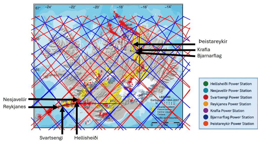
The distribution of geothermal activity in central parts of Norht Iceland

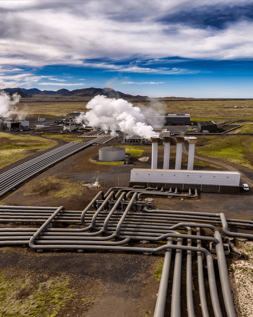
Eyjafjörður, however, remains an important area of geothermal utilization. Significant activity is found there, particularly in the Hjalteyri geothermal field, which produces around 110 liters per second of hot water. This accounts for roughly 60% of the heating supply for Akureyri, a town of about 20,000 inhabitants and often referred to as the capital of North Iceland. The use of geothermal energy here highlights how Iceland effectively harnesses subsurface heat for sustainable urban development.

Further east lies the Mývatn region, one of the most volcanically active areas in the country, centered around the Krafla volcanic system. This area has experienced numerous eruptions in historical times, including the well-known Krafla Fires in the 18th century and rifting episodes in the late 20th century. The region is characterized by high-temperature geothermal systems, extensive lava fields, pseudocraters, and active fissure swarms.

Geothermal and volcanic activity in this region continues northward beneath the surface, extending all the way to the ocean in Öxarfjörður. This follows the active plate boundary between the North American and Eurasian tectonic plates, part of the Mid-Atlantic Ridge system that crosses Iceland.

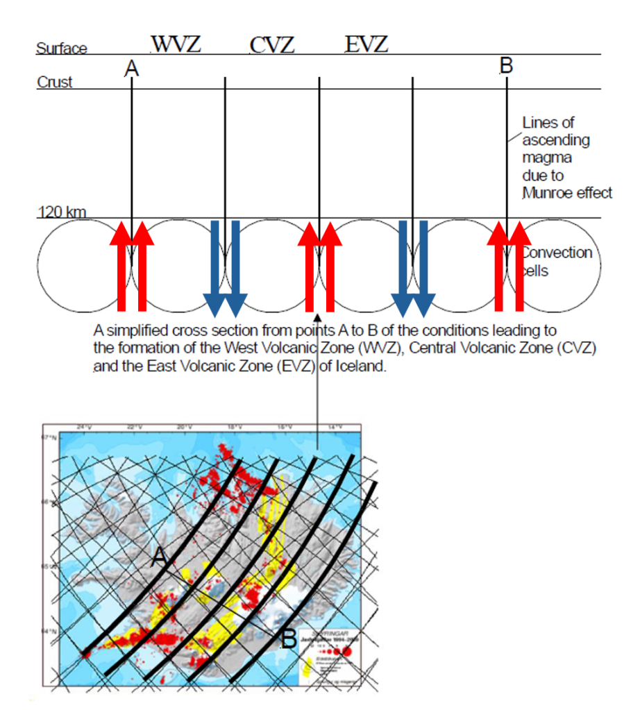
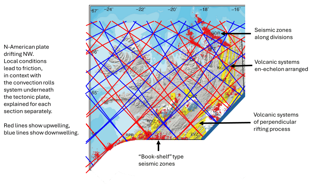
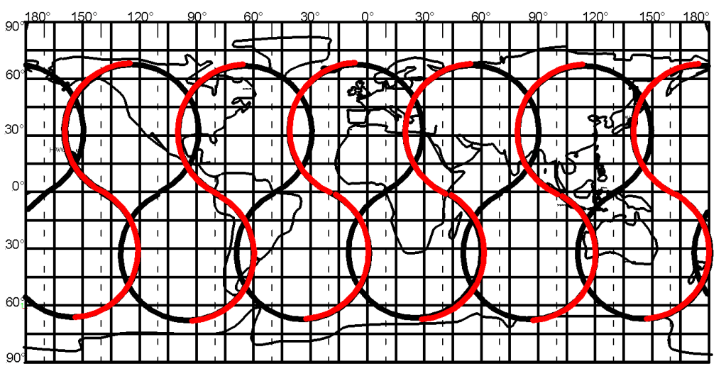
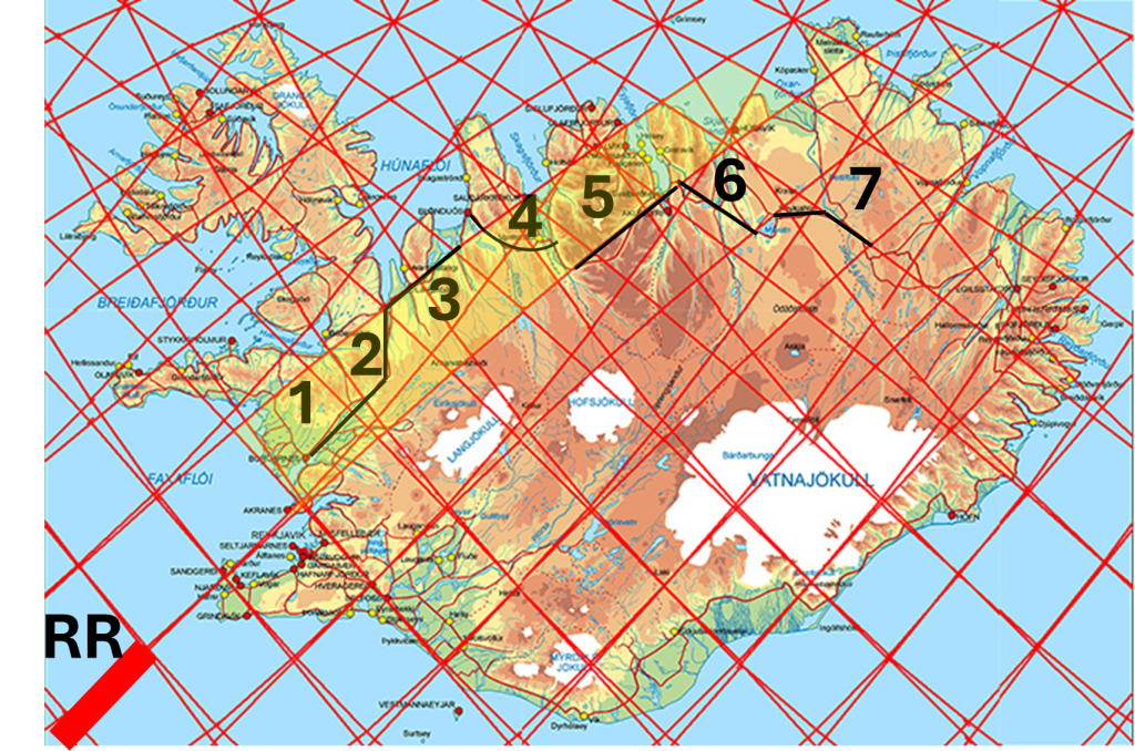
Knowing the location of convection rolls of different layers, the geothermal activity can be analyzed in more detail than previously possible. The impact of horizontal drift of the tectonic plates on one hand, and that of vertical effect of ascending magma on the other hand can be studied, and besides that local effect of horizontal flow of magma within particular convection rolls can be taken into account. Understanding those three main factors, geology becomes much more understandable.

The study area
Uncategorized

Two outposts of the Ring of Fire: Yellowstone and Changbai

At first glance, the Yellowstone hotspot and the Changbai Mountains seem to lie far outside the familiar boundaries of the Ring of Fire. They are usually treated as exceptions, features belonging to entirely different systems. But what if they are not exceptions at all? What if they are clues? See: https://www.youtube.com/watch?v=3C2HVOB-g5s

Ring of Fire – geometrical shape with Changbai Volcano and Yellowtone Caldera pointed out.

A geometrical starting point

Trying to define a strict geometrical shape for the Ring of Fire may seem futile. Still, it is worth attempting, not as a final answer, but as a way of revealing structure. A useful starting point is to consider two major anchor regions roughly 150° apart along the equator: the subduction zones along Indonesia and those along the west coast of South America. These are not arbitrary points; they represent fundamental expressions of how the Pacific Plate interacts with its surroundings.

From here, an elliptical form can be traced around the Pacific basin. It is basically a perfect ellipse. The Earth is rotating, and the Coriolis effect acts in opposite directions in the two hemispheres. The result is a systematic distortion: the structure is skewed westward in the Northern Hemisphere and eastward in the Southern Hemisphere.

Why the Ring is not a ring

This distortion helps explain something that has long puzzled geologists: the Ring of Fire is not actually a closed ring. It resembles a horseshoe.

One key reason lies in the western Pacific. Subduction zones there, particularly the Tonga–Kermadec system, do not simply trace the outer boundary. Instead, they appear within it, as if mirrored inward. This is consistent with a rotating system where structures are not just arranged spatially, but dynamically shaped. The “ring” is therefore not a rigid boundary. It is the visible expression of a deeper, moving system.

Extending the pattern

If this geometrical framework has any validity, it should not stop neatly at the edges of the Pacific. And indeed, it does not. Volcanic regions in Antarctica can be fitted into the same broad pattern. This alone suggests that we are not dealing with a local phenomenon, but with something that reflects global-scale mantle behavior. And this is where the two outposts come back into focus.

Rethinking Changbai

The Changbai Mountains have long been considered outside the Ring of Fire. Yet seismic evidence shows that material from the Pacific Plate has descended into the mantle transition zone (410–660 km depth) and then spread laterally beneath northeastern Asia. In other words, the influence of Pacific subduction does not stop at the trench. It continues far beneath the surface, so therefore Changbai is not disconnected. It is linked, but in a way that is not immediately visible from above.

Yellowstone as a counterpart

On the opposite side, Yellowstone sits deep within the North American continent. It is typically explained as a mantle plume, rising independently from great depth. But its position relative to the broader geometry is striking. If we extend the distorted elliptical framework, Yellowstone lies close to its outer margin, mirroring Changbai on the other side of the Pacific system.

Beyond the outline

So what lies behind the geometry? The Ring of Fire, when viewed not as a boundary but as a pattern, appears to outline something larger: a system of long, connected mantle flows encircling the Pacific. Subduction zones are only the surface expression of this system. The deeper structure may extend far beyond them, both laterally and vertically.

In that context, Yellowstone and Changbai are not anomalies. They are signals. They suggest that the system does not end at the edges we draw on maps. It continues beneath them. And that may be where the real structure lies.

Uncategorized

The division line of the West Volcanic Zone of Iceland

By examining a relief map of Iceland, key geological features become far more apparent than they would otherwise. One such map is displayed in the lobby of the visitor center at Þingvellir.

The main division line of West Volcanic Zone and its surroundings

A broken red line has been drawn to delineate the boundary along the western margin of the Western Volcanic Zone. This boundary can be traced continuously from north to south across the landscape. At its northernmost extent lie Hveravellir, a significant high-temperature geothermal field situated in the central highlands. Immediately to the west is Langjökull, beneath which two volcanic systems are located. Proceeding southward, one encounters Hvítárvatn, a proglacial lake that serves as a major outlet for meltwater from Langjökull and lies directly on this geological boundary.

Further south, the Jarlhettur form a row of hyaloclastite ridges aligned along the same divisional trend. This boundary corresponds to the interface between two mantle convection rolls beneath the approximately 120 km thick lithospheric plate. In addition to this division, deeper convection rolls boundaries are present, above which lies the Geysir geothermal area.

South of this part, volcanic formations of a different character emerge, including Laugarvatnsfjall, located above the lake Laugarvatn, pointed out on the map. These formations extend westward to Kálfstindar at the side of the Þingvellir graben, which follows the same orientation as the main boundary shown here. The geothermal activity at Laugarvatn is well documented. Immediately south of Laugarvatn lies the shield volcano Lyngdalsheiði. The boundary intersects the summit crater Þrasaborgir.

Notably, the hydroelectric power stations along the Sog river are situated on this boundary, marking a transition from highland terrain to the west to lower elevations in the east. The former waterfall Ljósafoss was located precisely along this division. Further south lies the mountainous region associated with Hrómundartindur, of which Reykjafell, near Hveragerði, forms a part. Here, deeper boundaries between mantle convection rolls extend westward beneath the Hengill volcanic system. South of this area, sharply defined structural boundaries known as Hlíð appear. These correspond in practice to the eastern flank of the shield volcano Skálafell and associated volcanic formations along the eastern edge of the Western Volcanic Zone.

In this region, the mantle convection rolls rotate in opposite directions. The western side coincides with the West Volcanic Zone, where one convection roll resists the northwestward motion of the North American Plate. In contrast, the area to the east is transported along with the underlying mantle flow. Consequently, the western region is subjected to continuous extensional forces, resulting in crustal rifting. This process is most clearly expressed in the rift valley at Þingvellir.

Uncategorized

Mapping Volcanoes to Mantle Flow in the Aegean Sea

The South Aegean Volcanic Arc, including Santorini, is one of the most active and famous volcanic regions of the Mediterranean. It formed mainly through subduction of the African Plate beneath the Aegean/Eurasian region along the Hellenic subduction zone. The arc includes, from west to east, the volcanic fields of SousakiAegina–Methana–Poros; Milos; Christiana–Santorini–Kolumbo; and Kos–Nisyros–Yali/Gyali.

In the convection-roll model, the arc is highly symmetrical around the central axis of the Aegean Sea, and the model as well, while still being affected by the westward tectonic drift of the Anatolian region. The volcanoes appear to fall along specific modeled convection-roll lines. This close fit between a mathematical model and observed surface volcanism adds statistical support to the relevance of the model.

The volcanic alignment can be summarized as follows:

Sousaki, Aegina, Methana, and Poros are situated above the westernmost set 1.
Milos lies above the second set of downwelling lines.
Central Axis: Santorini and Kolumbo are located near the central axis of the Aegean Sea.
Nisyros, Gyali (Yali), and Kos are positioned above the easternmost downwelling line of set 4.

Within the South Aegean volcanic arc, four sets of lines are identified in the convection-roll model. However, volcanic centers are concentrated above only three of these. Notably, no volcanoes are observed directly above the line of the pair marked as number 3. Instead, volcanic activity, most prominently at Santorini and Kolumbo, is located between lines marked as 2 and 3, aligning closely with the central axis of the Aegean Sea.

This pattern suggests that the central axis may act as a preferential path for magma ascent. Similar axial focusing has been observed in other tectonic settings, such as Iceland (particularly the North Volcanic Zone), where mantle upwelling and crustal weaknesses combine to localize volcanism and high temperature areas along a central N-S aligned axis.

Within the framework of this model, it can be hypothesized that mantle material associated with line 3 does not produce surface volcanism directly above it. Instead, the flow may be laterally redistributed, potentially westward, before rising along zones of reduced lithospheric strength at the central axis. This would imply that the interaction between convection patterns and lithospheric structure plays a key role in determining the final location of volcanic activity.

This suggests that the division lines of the convection rolls play a decisive role in determining the exact locations of volcanic activity. The activity itself is, of course, initiated by the subduction of the African Plate and the associated processes. As in many other regions of the world, subduction creates a volcanic arc that is clearly detectable at the surface and is dotted with volcanoes. It is precisely at the points where the convection-roll division lines intersect this arc that volcanic centers appear.

In this context, the blue downwelling lines may also be interpreted as marking conduits for ascending magma. The term “downwelling” refers to the slow convection of plastic mantle material; however, along the boundaries between convection rolls, at the division lines, partial melting can occur. This process may create zones of weakness within the lithosphere, providing favorable conditions for magma ascent and, ultimately, volcanic activity at the surface.

Uncategorized

How Basaltic Magma Ascends within Subduction Zones

I did discuss how magma must ascend from below the descending slab. If not, there would not be enough mantle material available for partial melting, not enough heat because of the cooling effect of the slab, etc. Simplifying the picture, emphasizing on the ascending magma only, the idea can be drawn AI-style:

In this way the production of basalt for Mt. Fuji, for instance, can be explained.

This can be tested by comparing sections of subduction zones with the model.

Fuji

There are many examples of how the model shows consistency with actual circumstances, position, alignment, and length. Trenches and volcanic zones also tend to coincide with convection rolls, the trench following the scope of a roll, then one roll is found in between the trench and the volcanic roll, and finally the bulk of volcanic activity is found in context with one roll. These three rolls are parallel to each other. The volcanic activity also tends to terminate at the border of a polygon. Here, two examples of this type of subduction are provided, from different corners of the Pacific Ocean:

The geology of these areas should then be analyzed for each of those diamond-shaped areas marked on the maps.