Uncategorized

Geometrical Presentation of the Ring of Fire

Main Sections of the Ring of Fire (clockwise)

Geometrical Presentation of the Ring of Fire.

1. Aleutian Islands and Alaska Peninsula

  • Classic subduction arc
  • Aleutian Trench
  • Pacific Plate subducting northward beneath North America
  • Shows segmentation and slab variability

2. Queen Charlotte–Fairweather Fault System

  • Major transform boundary
  • Right-lateral motion between Pacific and North American plates
  • Transition from subduction to strike-slip

3. Cascadia

  • Cascadia Subduction Zone
  • Juan de Fuca Plate subducting beneath North America

4. California

  • Dominated by San Andreas Fault and California Bay
  • Transform motion
  • High seismic activity, limited volcanism

5. Central America

  • Middle America Trench
  • Cocos Plate subducting beneath Caribbean Plate
  • Well-developed volcanic arc

6. Peru

  • Part of the Andean subduction system
  • Nazca Plate subducting beneath South America

7. Chile

  • One of the most active subduction zones on Earth
  • Deep trench and extensive volcanism
  • Site of major megathrust earthquakes

8. Antarctic Peninsula

  • Continuation of Andean-type subduction
  • Interaction between Antarctic, Scotia, and South American plates
  • Complex tectonic transitions

9. Antarctica

  • More diffuse tectonic setting
  • Volcanoes

10. Antarctica to Mid-Ocean Ridge

  • Transition from subduction-related systems to divergent boundaries
  • Includes spreading centers of the Southern Ocean

11. Mid-Ocean Ridge to New Zealand

  • Pacific-Antarctic Ridge
  • Seafloor spreading
  • Transition toward complex plate boundary near New Zealand

12. Tonga–Kermadec Subduction Zone

  • Tonga Trench
  • Among the fastest and deepest subduction zones
  • Very steep slab geometry

13. Trenches Connecting Guinea and Tonga

  • Region including New Hebrides (Vanuatu) subduction system
  • Complex interaction of microplates
  • Highly active volcanism and seismicity

14. Philippine Trench

  • Philippine Trench
  • Westward subduction of the Philippine Sea Plate
  • Multiple interacting subduction systems nearby

15. Ryukyu Trench

  • Ryukyu Trench
  • Subduction beneath the Ryukyu Arc
  • Back-arc extension in the Okinawa Trough

16. Kuril Islands and Kamchatka

  • Kuril-Kamchatka Trench
  • Classic Pacific Plate subduction beneath Eurasia
  • Highly active volcanic arc

Additional Key Reference Points

These are important markers in your framework, linking geometry and deeper structure:


A) Western Equatorial Point

  • Key symmetry point along the equator
  • Potential reference for large-scale mantle structure

B) Eastern Equatorial Point

  • Counterpart to the western point
  • Defines global-scale division of the Pacific system

C) South Island

  • Transition between subduction and transform (Alpine Fault)
  • Oblique plate motion

D) Yellowstone

  • Intraplate volcanism
  • Often linked to deep mantle processes

E) North Island

  • Active subduction (Hikurangi margin)
  • Volcanic arc and back-arc extension

F) San Andreas Fault

  • Major transform boundary
  • Separates Pacific and North American plates

G) Challenger Deep

  • Deepest point in the oceans
  • Extreme subduction environment

H) Hawaii

  • Intraplate hotspot chain
  • Indicates deep mantle upwelling

J) Japan

  • Complex multi-trench system
  • Interaction of Pacific, Philippine, and Eurasian plates

This represents a highly comprehensive description of the Ring of Fire. The underlying causes can be considered from several perspectives. One key factor is the presence of two reference points along the equator, which appear to define the foundation of a large-scale symmetric structure. Rather than forming a perfect circle, this structure resembles a mirrored ellipse, skewed westward in the Northern Hemisphere and eastward in the Southern Hemisphere. This asymmetry may reflect the influence of Earth’s rotation, which affects large-scale flow patterns in a consistent manner. In contrast, a non-rotating Earth would be expected to produce a more uniform, circular geometry.

The boundaries of both the outer and inner parts of this system can also be interpreted within this framework. Not only do the equatorial reference points appear to play a central role, but comparing the details with additional control points throughout the mantle convection system, it seems like they too contribute to shaping the overall structure.

When examining specific details, further intriguing patterns emerge. Along the minor axis, key features such as New Zealand, the San Andreas Fault, and Yellowstone are aligned. Along the major axis, systems such as Japan stand out. A north–south axis can be associated with Hawaii, while the Challenger Deep appears to lie along a principal line within the inner structure of the system. Even the configuration of mid-ocean ridges shows a degree of resemblance to segments of this broader circular or elliptical pattern.

These recurring geometric relationships suggest that the Ring of Fire may reflect a deeper, organized structure within the Earth system, and horozontally the global arrangement is clearly not random at all. Saying ‘not random’ is an inverse scientific statement 🙂 This makes people curious, and this makes people surprised. At the same time, this indeed does raise important questions about the mechanisms responsible for producing such large-scale coherence.

Uncategorized

History of the Common Sense of Plate Tectonics

At the start of the 20th century, geology faced a fundamental problem:
continents appeared to move, but no physically acceptable mechanism existed.

In 1912, Alfred Wegener presented the theory of continental drift. He argued that continents had once formed a single landmass (Pangaea) and later separated. His evidence — fossil correlations, matching geological structures, and continental fit — was compelling. However, Wegener could not provide a convincing driving force, and his ideas were widely rejected.

Meanwhile, a crucial breakthrough came from physics. Between 1896 and 1905, building on discoveries by Becquerel and the work of Ernest Rutherford, scientists established that radioactive decay produces heat. This insight solved a major constraint: Earth was not simply cooling, but continuously generating internal heat. By the early 1900s, it became clear that Earth possessed a long-lived energy source capable of driving internal processes.

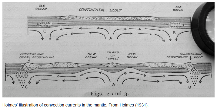
The next step was to understand how that the radioactive decay provided primary energy. In 1928–1929, Arthur Holmes proposed that heat inside the Earth drives mantle convection. He suggested that hot material rises and cooler material sinks, forming large-scale circulation patterns. Crucially, Holmes connected this internal flow to the drift of continents — proposing that convection currents could carry them. This was the first physically plausible mechanism linking Earth’s internal energy to surface motion.

However, direct evidence was still lacking — especially beneath the oceans, which remained largely unexplored.

That changed after World War II. Between 1950 and 1962, advances in sonar mapping revealed mid-ocean ridges, deep-sea trenches, and the global structure of the ocean floor. In 1962, Harry Hess proposed seafloor spreading: new oceanic crust forms at mid-ocean ridges, moves outward, and is eventually consumed at subduction zones.

Soon after, in 1963, Vine and Matthews demonstrated symmetrical magnetic striping on the ocean floor, providing strong confirmation that seafloor spreading was real and continuous.


The Synthesis (Late 1960s)

By 1967–1968, these ideas converged into the modern theory of plate tectonics:

  • Radioactivity (1896–1905) → provides the internal heat
  • Convection (Holmes, 1928–29) → organizes that heat into motion
  • Seafloor spreading (Hess, 1962) → reveals how crust is created and recycled
  • Magnetic evidence (1963) → confirms continuous movement

The Earth was finally understood as a dynamic system, not a static one.


The Physical System

The emerging model describes a coupled system:

  1. Heat from radioactive decay drives mantle convection
  2. Convection creates organized flow within the mantle
  3. This flow moves rigid lithospheric plates
  4. Plates:
    • diverge at ridges
    • converge at subduction zones
    • slide past along transform faults

Continents are therefore not independent — they are embedded in moving plates, which reflect deeper flow patterns.


The Deeper Insight

The key realization of the 20th century is that Earth behaves as a thermally driven engine:

  • Energy source → radioactive decay
  • Transport mechanism → convection
  • Surface expression → plate tectonics

What began as disconnected observations became a unified physical framework linking nuclear physics, fluid dynamics, and geology.


Extending the Framework

The classical model (Holmes → Hess → plate tectonics) established that convection drives tectonics.

Uncategorized

The Mantle Convection Rolls Grid

Understanding the geological processes in Iceland and elsewhere, both tectonic drift and mantle currents have to be considered.

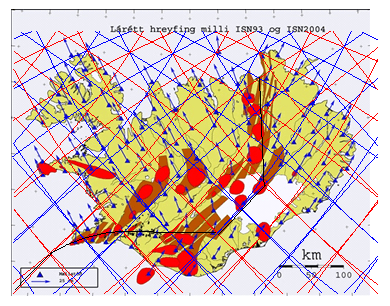
This map shows it all, tectonic drift vectors from the National Land Survey of Iceland. The grid of division lines superimposed on this map shows the outlines of convection rolls below Iceland. The convection rolls can not be measured yet, due to several reasons.

5 Core Factors + 2 Observables:

5 CORE FACTORS (causes in the mantle)

Temperature

Composition (chemistry)

Pressure / depth

Mineral phase (structure)

Partial melt / fluids

 2 OBSERVABLES (what we measure)

Seismic velocity (Vp, Vs)

Attenuation (Q)


An addition to low resolution, these factors make it too complicated to get a clear picture of the vertical structure aspects of the mantle. But the methods used here to make the convection rolls model are a shorter way, thereby deducting these lines before modern sensors, relevant AI and other types of technology provide direct observation opportunities.

Each of those lines shows the division between two convection rolls, found below Iceland at different depth, but all of them affect the tectonic plates of N-America and Eurasia. The first demonstration is how the volcanic zones follow the scope of the convection rolls. The only way to explain this consistency is finding out how those division lines affect the tectonic plates (and the crust). Ignoring this consistency would be wrong.

This leads us to consider further what happens down below, within the asthenosphere, the transition zone of the mantle, and the lower mantle. These lines are really narrow and sharp, so the way magma ascends through the tectonic plate should be analysed. The only way is the accumulation of martial melt exactly where the division lines are found, a mechanism of the convection rolls to release the partial melt there and make it possible for the lines of ascending magma to proceed all the way upwards, a distance of 120 km.

With this in mind, a myriad of geological features can be explained, hitherto hidden and not understood.

As can be seen on the map, the tectonic drift vectors are remarkably parallel to the convection rolls. This is a mathematical coincidence, found at the starting point of tectonic drift of the two plates. Farther out, this consistency is not seen, as the two plates drift and rotate in their independent ways.

Uncategorized

Examining how the Earth works

A Holistic Model of Energy Flow Within the Earth

The internal energy flow of the Earth can be approached through a set of simple but physically meaningful preconditions that together form a coherent conceptual model.

The first precondition is that radioactive decay supplies an energy output comparable to the total heat flux emitted by the Earth. This assumption is supported by geochemical evidence suggesting that the abundance of radioactive isotopes—particularly uranium-238, thorium-232, and potassium-40—in primitive meteorites is broadly consistent with the inferred composition of the Earth. If so, radioactive decay could account for the entirety, of Earth’s present-day heat loss.

The second precondition is that the mantle is partially transparent to thermal radiation, particularly the radiation produced by these radioactive elements, along with the outer core. Under this assumption, a portion of the radiative energy generated within the mantle can propagate downward and be absorbed by the inner core. In this framework, the inner core is not merely a passive reservoir of residual heat, but an active participant in a dynamic energy exchange system.

Energy received by the inner core is then redistributed through convection within the outer core, which acts as an efficient transport mechanism. This convective motion transfers heat upward toward the mantle across the core–mantle boundary (CMB), a region that plays a critical role in coupling deep Earth processes. From there, heat continues to move through the mantle by a combination of convection and radiation, ultimately reaching the base of the lithosphere.

Within the tectonic plates, heat is transported toward the surface through conduction and localized magma flow, giving rise to volcanic and tectonic activity. In this way, the model provides a continuous pathway for energy: from radioactive sources, through radiative transfer and convection, to surface expression.

A central point of debate concerns the radiative properties of the mantle. Conventional models often assume that the mantle is largely opaque to thermal radiation, which limits the role of radiative heat transfer. However, this assumption remains uncertain, particularly under the extreme temperatures and pressures of the deep mantle. If the mantle is more transparent than typically assumed, radiative energy transfer could play a significantly large role in Earth’s internal energy budget.

Another debated issue is whether the inner core is growing over time. Some models suggest gradual solidification of the core, while alternative perspectives argue that the core maintains relatively stable proportions and temperature through long-term dynamic equilibrium. If such stability holds, it would support a model in which energy input—potentially via radiative transfer—is balanced by outward heat flow.

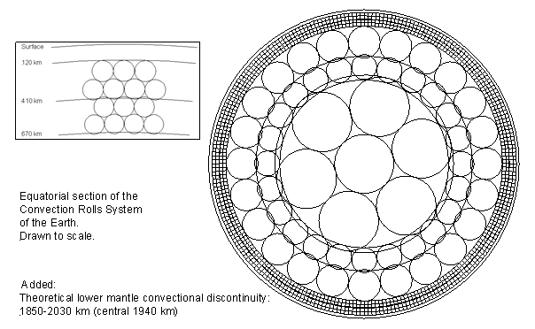
To explore the implications of this framework, convection rolls can be introduced into mantle layers as a simplified representation of large-scale flow. These structures provide a useful basis for comparison with observed surface patterns, such as tectonic plate boundaries, volcanic distributions, and heat flow variations. Preliminary comparisons, shown here, suggest that such models may reproduce certain large-scale features of the Earth’s surface, indicating that the approach is worthy of further investigation.

Basic convection rolls model, equatorial section

Conclusion

This holistic model proposes a testable alternative framework for understanding Earth’s internal energy flow. Its validity depends on key assumptions—such as the radiative transparency of the mantle and the long-term stability of the core—which can, in principle, be evaluated through observation, experiment, and modeling. The consistency between the mantle convection roll model and observed surface features has been rigorously tested here and shows strong agreement.

Uncategorized

Structural Parallels Between Eastern Indonesia and the East African Rift

A 90° Connection?

Introduction

At first glance, eastern Indonesia and the East African Rift appear to have little in common. One is dominated by deep ocean trenches and subduction zones, while the other is defined by continental rifting and volcanic valleys.

Yet when examined more closely, and positioned relative to specific longitudinal reference points, a striking structural similarity emerges.

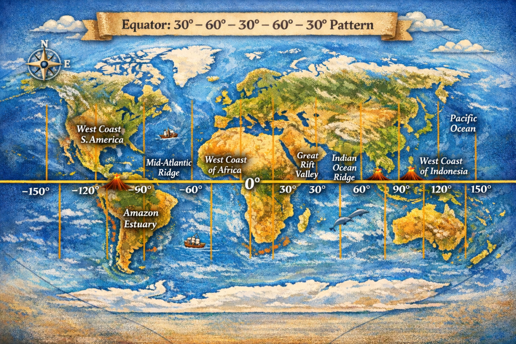
Similarities and coherence along equator
between Great Rift Valley and East Indonesia, with Amazon Estuary included.

Two locations, separated by exactly 90° in longitude (128.9°E in Indonesia and 38.9°E in East Africa), reveal comparable patterns of tectonic division. In both regions, deformation is not concentrated along a single boundary but instead distributed across multiple, parallel or opposing systems.

This raises an important question:
Are these similarities coincidental, or do they reflect deeper, global-scale organization within Earth’s mantle?


The Indonesian Reference Point: A Rare Double Subduction System

https://www.researchgate.net/publication/228495652/figure/fig1/AS%3A668987138535446%401536510371575/Detailed-tectonic-map-of-Molucca-Sea-area-displaying-geographic-features-described-in.png
The calculated convection rolls grid superimposed on a map
showing the Molucca Sea and the related subduction zones.

The point at 128.9°E lies just south of the Philippine Trench, within one of the most tectonically complex regions on Earth.

Immediately to the west lies the Molucca Sea region, characterized by a highly unusual configuration:

  • Two opposing subduction zones
  • Oceanic crust being consumed from both sides
  • Formation of colliding island arcs

This system is often described as a double subduction zone, where the Molucca Sea plate is being subducted both eastward and westward.

Key structural feature:

Deformation is split into multiple opposing boundaries rather than a single subduction interface


The African Reference Point: A Bifurcating Continental Rift

At 38.9°E, we encounter the East African Rift—a region where the African continent is actively splitting apart.

Unlike Indonesia, this is a divergent system, yet it shows a comparable structural division:

  • The rift splits into two distinct branches:
    • Eastern Rift
    • Western Rift
  • These branches run roughly parallel, enclosing a broad zone of deformation

Key structural feature:

Extension is distributed across multiple rift valleys instead of a single division.


Structural Similarity: Different Processes, Same Geometry

Despite their very different tectonic regimes, both regions share a common structural pattern:

FeatureEastern IndonesiaEast Africa
Tectonic regimeConvergent (subduction)Divergent (rifting)
StructureOpposing trenchesParallel rift branches
Deformation styleCompressionExtension
Common traitMulti-branch divisionMulti-branch division

Insight:

In both cases, the lithosphere does not deform along a single boundary.
Instead, it splits into multiple systems.


A Mantle Perspective: Distributed Deformation and Flow Organization

Both regions are located above areas of intense mantle activity:

  • Eastern Indonesia sits at the intersection of multiple major plates and microplates
  • East Africa overlies a mantle upwelling.

Within the framework of large-scale mantle convection:

  • Flow is not necessarily localized
  • Instead, it may organize into Reylaigh-Bénard type of convection rolls, very well known in physics.
  • These can produce zones of regular deformation at the surface

Hypothesis

Regions of strong mantle flow may not produce a single tectonic boundary, but instead generate paired or multiple systems, reflecting the motion in the overlying lithosphere.

In this view:

  • The double subduction in Indonesia (with two others just north and south of there)
  • And the dual rift system in Africa

…are different surface expressions of a similar underlying principle:
Deformation partitioning driven by large-scale mantle dynamics


Beyond Coincidence

The comparison between these two regions suggests that:

  • Complex tectonic features may follow recurring structural patterns
  • These patterns may not depend on whether the regime is compressional or extensional
  • Instead, they may reflect how mantle flow organizes lithospheric deformation

This aligns with a broader idea:

Earth’s surface tectonics, as in this case, may be better understood not as isolated plate boundaries, but as parts of a coherent, global system of mantle-driven structure

At approximately 51.1°W, 90° west of East Africa, lies the Amazon River estuary.

Unlike the other two regions, this is not an active plate boundary. It is part of a passive continental margin. However, it is far from simple.

Key characteristics include:

  • One of the largest sediment discharge systems on Earth
  • The Amazon deep-sea fan extending far into the Atlantic
  • A margin shaped by long-term interaction between:
    • Continental structure
    • Ocean basin evolution
    • Sediment loading and flexure

While not tectonically “active” in the same way, it represents a major function of mass redistribution and lithospheric response, and therefore its location can be connected with local lithospheric preconditions.


A Three-Point Pattern

We now have three locations:

  • 128.9°E → Eastern Indonesia (double subduction)
  • 38.9°E → East African Rift (dual rift)
  • 51.1°W → Amazon margin (major sedimentary system)

Each separated by roughly 90° in longitude.


Conclusion

The apparent symmetry between eastern Indonesia and the East African Rift—highlighted by their 90° longitudinal separation and shared multi-branch structure—invites a deeper, while the tectonic mechanisms differ, the structural resemblance is difficult to ignore. Adding the Amazon estuary, also with 90° longitudinal separation as compared with the East African Rift, this arrangement must be regarded as based on something else than coincidence. It should be kept in mind that all those locations are found exactly on the equator.

Rather than viewing these regions as unrelated anomalies, they may represent:

Different manifestations of a common, deep currents within Earth’s mantle