geology

Tahiti – calculated

cottages in the middle of beach
Photo by Julius Silver on Pexels.com

Tahiti is amazingly far away from any mainland. It can be compared with Hawaii, because it has a hot spot at Mehetia. The drift of the Pacific Plate creates a chain of islands. The calculated value of directions can be achieved in the same way as for Hawaii:

Tahiti 01

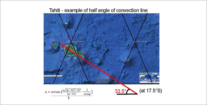
This is very close to the measured value of tectonic drift, that is N65°W.

The relevant convection rolls division line is found directly under Mehetia.

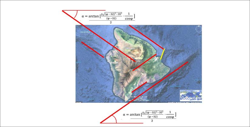
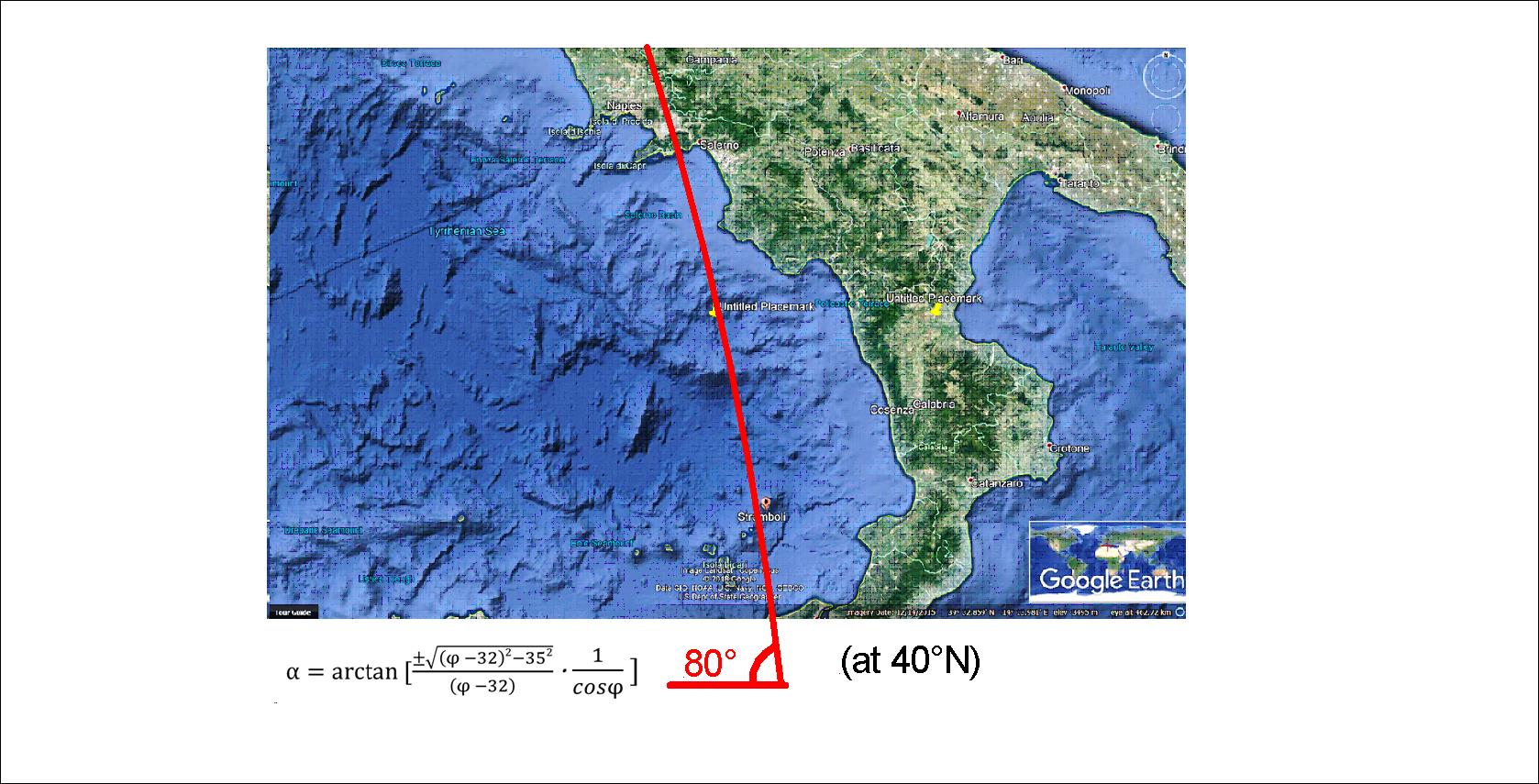
Here is the calculated value for Hawaii, for a quick comparison 🙂 Note that the calculations are double for Hawaii (NW and NE trending vectors), because the symmetric effect of the two convection rolls layers appears clearly.

Hawaii - 03


geology

Baffinsland and Iceland at the same latitudes – what do they have in common?

The south of Baffinsland is shaped in the same way as Iceland. Just compare these drawings:

Iceland and Southern Baffinsland

It is obvious that the main faults and coastlines follow the lines. It is also important that at 64°N, Baffinsland extends exactly 9° from coast to coast, or the width of 6 convection rolls. Just to clarify:

Iceland and Southern Baffinsland - second layer convection rolls only

In Iceland, at the same latitude as this part of Baffinsland, the upper most (first) layer is of course more apparently shaping the surface. Here is a map of Iceland (based on a map from Náttúrufræðistofnun), and the grid has exactly the same pattern as for Baffinsland:

Iceland division line

The numerous details can then by worked out by scrutinizing these maps.


geology

Greenland and Iceland – what do they have in common?

Comparing the west coast of Greenland with Iceland at the same latitudes reveals a common point. At 66°N the coasts are exactly 30° apart. As mentioned before, the basic extension along each latitude is 30°, because each convection roll is 30° wide.

Greenland and Iceland 30 at 66

Besides that, similar consistency is found between tectonics and analysis of convection rolls of the mantle in both countries.

This is how it looks:

Grænland - grind - 64 og 66

Just to have Iceland in similar scale to make comparison easier:

Iceland division line

There you see that the fjords of NW Iceland follow the equator originated set of lines to the NW, but in Greenland to the NE, but the deviation from east is actually the same, that is 35°.

geology

The mantle currents under Denmark

The distribution of Danish land can be explained according to the mantle currents.

This is a simplified convection rolls division lines drawing on a Google map base:

Jótland - Fjón - Sjáland - Skánn

This provides a base for analysis (if we are assured about the mantle convection system).

Therefore we can draw further by adding a few lines of reference:

Jótland - Fjón - Sjáland - 3

The main EW-axis goes right through Copenhagen, marked with a black line.

The easternmost point is also Copenhagen, and exactly 4.5° farther to the west is the west coast of Jutland. (Each convection roll extends 1.5° from east to west.)

This belt of Denmark is made up of three main polygons, one representing Jutland, one for the island Funen and one for the island Zealand, on which Copenhagen is located.

This provides a base for the geometry of Denmark.


geology

Etna, Stromboli and Vesuvius – how are they connected?

The three most famous volcanoes of Italy are all in the vicinity of the same convection division line:

Etna 01

The volcanoes Vesuvius and Stromboli are directly above the line. The line represents a division between convection rolls found at about 250 km depth. The black line represents the division between convection rolls at about 120 km depth. the margins of other parallel convection rolls are marked with thinner lines.

This gives us the opportunity to think about the difference between Vesuvius and Etna. It is common knowledge that Etna is located at the border line where the African tectonic plate slides under the European one. The ascending mantle underneath can then send lava up through the crust resulting in eruptions.

Note that this analysis changes nothing about traditional geology. But it becomes easier to understand if the convection rolls under the tectonic plates are taken into account.

And just to emphasize that this is calculated, based on sophisticated analysis, let us compare directly with local vector.

Stromboli - Vesuvius

This is how these volcanoes are connected within the mantle. This is calculated in the same way as for the tectonics and location of volcanic and geothermal sites in Iceland.