Blog

Uncategorized

Possible Formation of the Elliptical Icelandic Plateau by Symmetric Crustal Extension


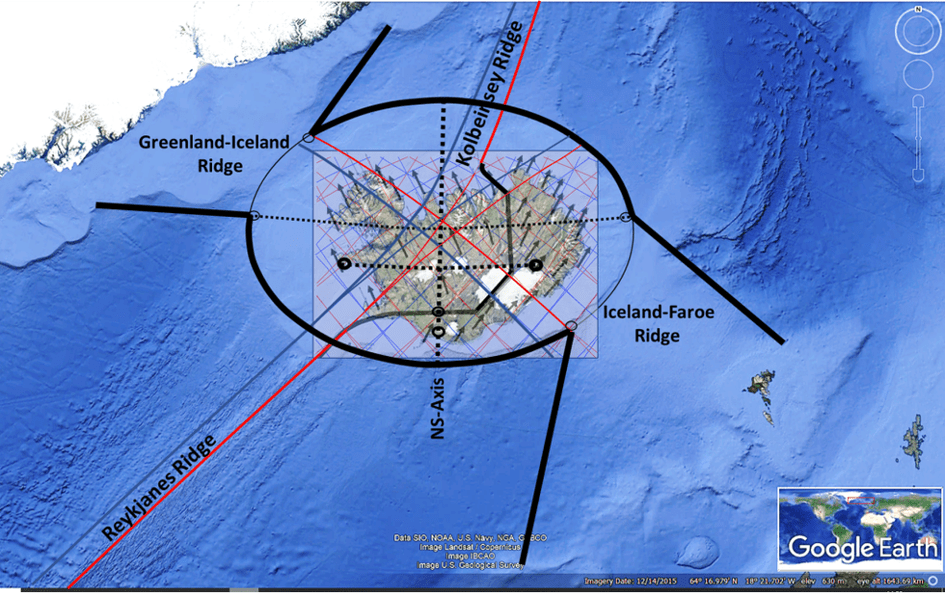
A striking feature of the Icelandic plateau is its broadly elliptical outline. The ellipse discussed here has its centre at approximately 65.600°N, 19.625°W. Its major axis is oriented exactly east–west along latitude 65.600°N, extending from approximately 27.300°W in the west to 11.950°W in the east. Its minor axis extends from approximately 63.000°N in the south to 68.200°N in the north.
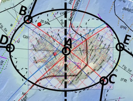
The elliptical form of the Icelandic Plateau.

Map base: https://www.researchgate.net/publication/316330629_The_Greenland-Iceland-Faroe_Ridge_Complex

Using longitude λ and latitude ϕ, the ellipse is defined approximately by:
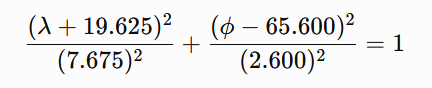
where λ denotes longitude, with western longitudes expressed as negative values, and ϕ denotes latitude.

The shape is particularly clear in the southeastern part of the Icelandic shelf, where relatively little later tectonic disturbance appears to have modified it. The most significant deviations occur in the northern sector, particularly around the Kolbeinsey Ridge, where younger spreading processes have substantially reorganized the crust. On geological and bathymetric maps, however, the elliptical geometry remains conspicuous. Of particular interest is that geological boundaries between the Icelandic part of the Greenland–Iceland–Faroe Ridge Complex and the adjoining ridge segments appear in places to follow the elliptical outline itself.

A stretched continental-crust interpretation

The geometry becomes especially interesting if the hypothesis proposed by Foulger and others is adopted as a working assumption: namely, that substantial amounts of stretched continental crust may remain beneath Iceland and parts of the Greenland–Iceland–Faroe Ridge Complex.

In such a model, Iceland would not consist exclusively of anomalously thick oceanic crust generated by excessive mantle melting. Instead, an older continental crustal component may have been progressively stretched, thinned, intruded by magma and covered by basalt during the opening of the North Atlantic.

If the remaining continental component beneath Iceland is approximately 20 km thick, whereas the original crust may have been 35–40 km thick, the crust must have undergone considerable areal extension. A simple volume-conservation calculation suggests that the original area could have been roughly one-half of the present affected area if the original crust was about 40 km thick.

The important point, however, is that the original block need not have been circular. It was probably elongated, because it represented part of the continental material being divided as Greenland separated from Europe. Its original structural connections would therefore naturally have extended toward Greenland on one side and toward the Faroe region on the other.

The Icelandic ellipse as a deformation envelope

The Icelandic ellipse should therefore not necessarily be interpreted as the original outline of a single continental fragment. A more plausible possibility is that it represents the finite deformation envelope of a wider zone of stretched continental crust.

The original continental material may have formed an irregular or elongated block, while long-term extension, lower-crustal flow, repeated rift relocation and magmatic intrusion produced a much smoother final deformation field. Over tens of millions of years, deformation distributed through a hot and mechanically weak crust can become considerably more regular than the original structural boundaries.

This possibility is compatible with several elements of Foulger’s model, particularly distributed extension, unstable and migrating spreading axes, broad transfer zones and ductile lower-crustal flow. Foulger does not propose the Icelandic ellipse itself, but the physical processes invoked in that model provide mechanisms through which a broad and relatively smooth deformation envelope could develop.

East–west extension

The major axis of the ellipse lies precisely east–west along 65.600°N. Within the mantle-convection-roll model, this is also an important structural latitude. The line passes through the central part of the northern volcanic-zone system when measured from north to south and through the geometric centre of the shelf ellipse.

The principal crustal extension can therefore be considered primarily east–west. This does not mean, however, that all deformation or material transport must have occurred east–west. The geometry suggests that the principal extension and the directions along which deformation was distributed may be different.

A useful distinction can therefore be made between the principal direction of extension, which was east–west, and the broader distribution of deformation, which appears to have taken place along northeast–southwest and northwest–southeast trends. This relationship may be fundamental to understanding the overall form.

Mirror-symmetric mantle boundaries

Within the mantle-convection-roll model, the major boundary associated with the Reykjanes Ridge continues through the central region beneath Iceland. It follows a curved SW–NE trajectory. A second underlying boundary forms a geometrical mirror image of this structure.

Both pass through the central region of the Icelandic ellipse. These two oblique systems can be considered mirror-symmetric components of a larger deformation field. This is mechanically important because two equally strong oblique deformation systems of opposite orientation can cancel their net shear while reinforcing their extensional components.

Schematically, if one system contributes a positive shear component, +γ, and its mirror-symmetric counterpart contributes an equal negative shear component, −γ, the two shear components cancel:

+γ+(−γ)=0

The net shear is therefore zero. The combined strain field can therefore retain principal axes oriented exactly east–west and north–south even though the underlying structural boundaries themselves are oblique. This offers a possible explanation for an otherwise curious feature: the Greenland–Iceland–Faroe system trends obliquely across the region, yet the Icelandic shelf ellipse itself is not similarly rotated. Its principal axes remain E–W and N–S.

Connections toward the Faroes and Greenland

The southeastern side of the ellipse connects with the Faroe segment of the ridge. The connection begins close to the eastern end of the major axis, near 65.6°N, 11.9°W, and continues southwestward toward approximately 63.3°N, 15.2°W.

This connection crosses the underlying convection-roll system obliquely rather than following a single roll boundary. According to the convection-roll model, it spans approximately five adjacent convection-roll elements, each separated by about 1.5° in longitude. Because the connecting zone crosses them obliquely, however, its real length and width cannot simply be calculated as (5\times1.5^\circ). The number five describes the number of underlying mantle units involved, rather than a direct geographical distance.

A corresponding connection occurs northwest of the major axis toward the Greenland segment of the ridge. It similarly extends across approximately five convection-roll elements but lies north of the 65.600°N major axis. The two connections therefore form complementary components of the same system:

  • a southeastern connection toward the Faroes;
  • a northwestern connection toward Greenland.

The Icelandic region between them is considerably wider than either connecting zone.

Why does the Icelandic region widen so much?

This may be one of the most important mechanical questions. If the connections toward Greenland and the Faroes are relatively narrow, why does the central Icelandic deformation zone expand into a broad ellipse roughly 700 km across? The answer may lie in the difference between a transfer zone and the deformation domain receiving the strain.

The Greenland and Faroe connections need not themselves be as wide as the Icelandic ellipse. Instead, they may transmit stress and deformation into a central region where the crust is hotter, weaker and more heavily intruded by magma. Once deformation enters such a mechanically weak domain, it can spread laterally.

A simplified sequence would therefore be: narrow oblique connection → broad, mechanically weak crustal domain → distributed extension and lower-crustal flow → development of an elliptical finite-strain envelope.

In this interpretation, the ellipse does not reflect the width of a single fault or rift. It represents the cumulative region over which deformation has been distributed.

Geological asymmetry superimposed on geometric symmetry

An important feature is that the ellipse is not preserved equally well on all sides. The southeastern sector appears especially regular. The geological boundary between the Icelandic region and the Faroe segment also seems to follow the elliptical geometry particularly clearly.

The Greenland-facing side appears sharper, whereas the Faroe-facing transition is broader and less abrupt. This difference does not necessarily contradict an originally symmetric underlying system. The subsequent tectonic histories of the two sides were different.

The largest disturbance occurs north of the 65.600°N axis around the Kolbeinsey Ridge. Spreading was reorganized in this region after the decline of the Aegir Ridge, and younger volcanic and spreading systems developed. These processes could have modified or overprinted an older elliptical deformation boundary.

Thus a distinction can be made between: primary geometric symmetry, controlled by the deeper system, and: secondary geological asymmetry, produced by later rift relocation, volcanism and crustal accretion.

Symmetry in degrees rather than kilometres

Another unusual aspect of the ellipse is that its symmetry is expressed in geographic angular coordinates. It is exactly symmetric about 65.600°N in latitude and 19.625°W in longitude. However, the Earth is spherical, and one degree of longitude becomes progressively shorter toward the north. Consequently, although the ellipse is geometrically symmetric in degrees, its northern half is physically smaller than its southern half when measured in kilometres.

At approximately 63°N, one degree of longitude corresponds to about 50 km, whereas near 68°N it is only about 41 km. The same east–west angular width therefore represents a greater physical distance in the south than in the north. This is important within the convection-roll hypothesis because the proposed mantle system itself is defined by angular divisions of the Earth. If the underlying mantle organization follows fixed longitudinal and latitudinal intervals, symmetry in degrees rather than kilometres would be expected within that model. This is quite different from an ordinary local strain ellipse constructed in a Cartesian coordinate system.

A possible combined mechanism

The emerging working hypothesis can therefore be summarized as follows. An elongated remnant of continental crust remained between Greenland and Europe during the opening of the North Atlantic. Beneath the Iceland region, the mantle-convection-roll system imposed a geometrically organized set of boundaries.

The principal crustal extension occurred in the east–west direction. At the same time, deformation was transmitted diagonally through two approximately mirror-symmetric systems extending toward Greenland in the northwest and the Faroes in the southeast. Because the two oblique systems are mirror-related, their shear components could largely cancel at the scale of the entire region while their extensional components reinforced one another. This allowed the principal axes of the cumulative strain field to remain east–west and north–south.

Divisions between Icelandic Plateau and continuations towards Greenland and Faroe Islands marked with red lines.

Within the Iceland region, hotter and weaker continental crust allowed deformation to spread laterally far beyond the widths of the narrower connections to Greenland and the Faroes. Ductile lower-crustal flow, repeated movement of spreading axes and extensive magmatic intrusion may have further smoothed the deformation field. The result could have been a broad, approximately elliptical finite-strain domain.

The Faroe and Greenland ridge segments would then represent narrower continuations of this larger crustal system rather than structures having the same width as the Icelandic central region.

Later tectonic reorganization, especially the development of the Kolbeinsey Ridge, subsequently disturbed the northern part of the original geometry. The most important observation is therefore not merely that the Icelandic shelf is approximately elliptical. It is that the geological boundaries, the central east–west axis, the connections toward Greenland and the Faroes, and the deeper mantle geometry proposed by the convection-roll model appear to form parts of the same symmetric system.

If the continental-crust interpretation is correct, the Icelandic ellipse may record the cumulative deformation of an old continental fragment whose extension was controlled not by a single rift axis, but by a wider and geometrically organized mantle deformation field.

The elliptical outline is particularly evident when compared with the geological and structural maps presented by Hjartarson et al. (2017). Their subdivision of the Greenland–Iceland–Faroe Ridge Complex shows distinct boundaries between the Icelandic shelf and the adjoining Greenland–Iceland and Iceland–Faroe ridge sectors. In particular, the southeastern geological boundary closely follows the elliptical outline described here. The elliptical interpretation itself is not proposed by Hjartarson et al.; it is introduced here as a geometric interpretation of the mapped structures.

The article: Hjartarson, Á., Erlendsson, Ö. & Blischke, A. (2017). The Greenland–Iceland–Faroe Ridge Complex. Geological Society, London, Special Publications, 447, 127–148. DOI: 10.1144/SP447.14.

https://www.researchgate.net/publication/316330629_The_Greenland-Iceland-Faroe_Ridge_Complex
Uncategorized

The Six Major Geyser Regions of the World

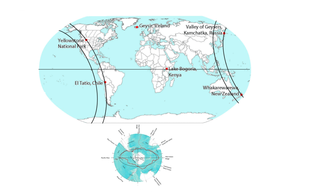
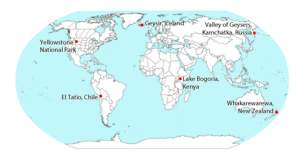
According to the USGS, six major geyser regions can be identified in the world: Iceland, Yellowstone in the United States, the Valley of Geysers in Kamchatka, the Taupō–Rotorua region of New Zealand, El Tatio in Chile, and Lake Bogoria in Kenya.

The six major geyser regions.

https://www.usgs.gov/media/images/map-showing-locations-major-natural-thermal-geyser-fields

For first comparison:

The Ring of Fire coinciding with geyser regions,
Iceland on minor axis, Lake Bogoria on the equator within Great Rift Valley.
Note that 90° separate Geysir and Yellowstone, and Geysir and the Valley of Geysers.

Geysers are rare because their formation requires a particular combination of geothermal heat, groundwater, permeable fractures, and a confined underground plumbing system in which water can become superheated before erupting at the surface.

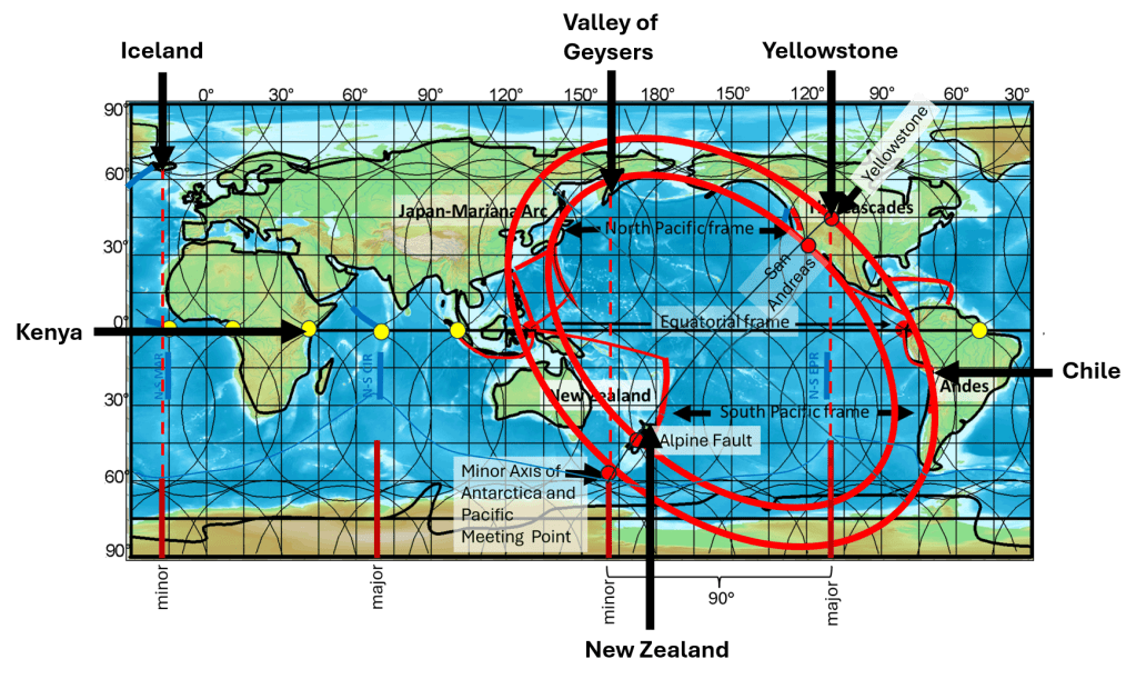
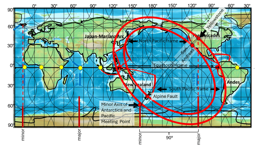
According to the geometric interpretation presented here, the locations of all six major geyser regions can be related to prominent axes, ellipses, and major tectonic divisions shown on the map below.

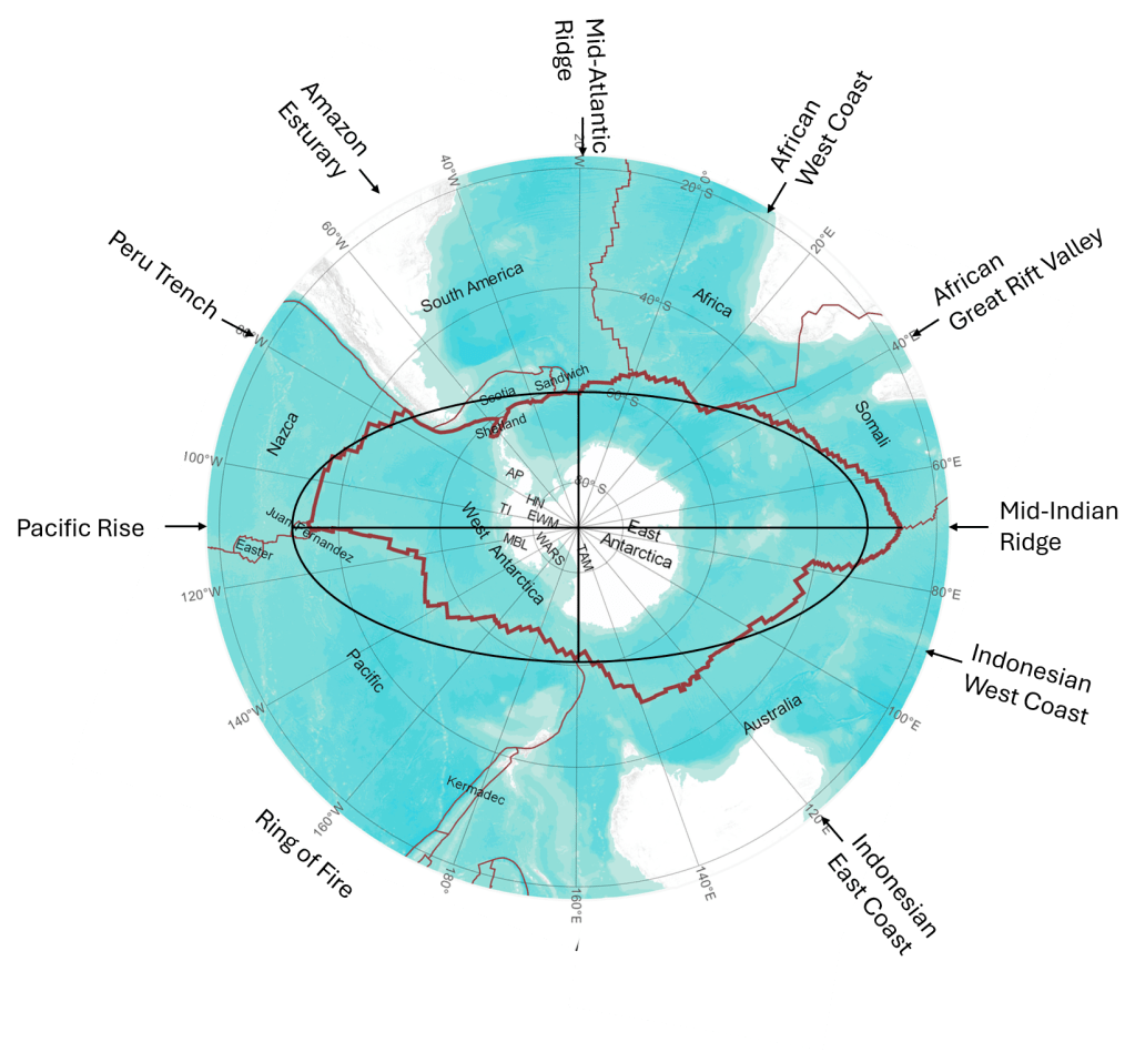
Iceland, Yellowstone, and Kamchatka all lie in direct continuation of the principal axes of the Antarctic ellipse. New Zealand is located near the intersection of the minor axis of the Ring of Fire and its inner elliptical form. Kenya is associated with the Great Rift Valley of Africa, close to the Equator, while El Tatio in Chile lies on the outer rim of the elliptical form of the Ring of Fire. Thus, all six of the world’s most prominent geyser regions can be related to the principal geometric features described here.

The ellipse of Antarctica.

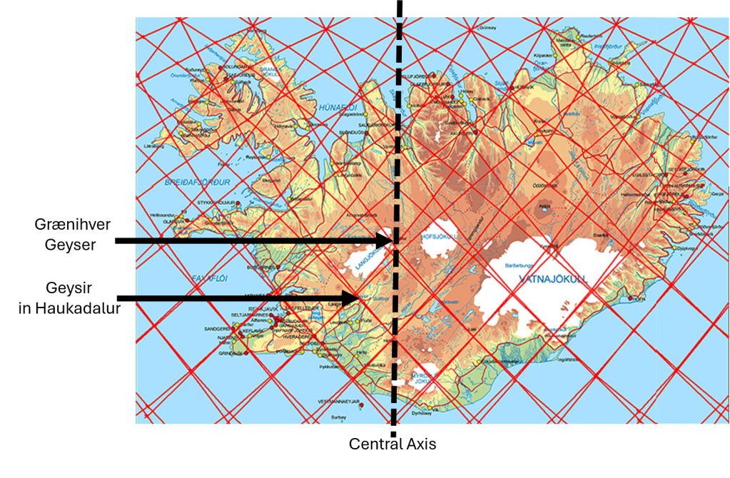
In the case of Iceland, the accuracy level is tremendous:

Location of Geysir in Haukadalur, and the smaller Geyser nearby, Grænihver.

1. Iceland – Geysir and Strokkur

Iceland contains one of the classic geyser regions of the world. The best-known examples are Geysir and Strokkur in Haukadalur. Strokkur erupts frequently, while the activity of Geysir has varied considerably through historical time.

The Icelandic geothermal systems are associated with intense volcanism, abundant groundwater, fractured volcanic rocks, and a high geothermal gradient. Water can circulate downward through fractures, become heated at depth, and rise again. In a geyser, restrictions within the underground conduit allow pressure to build until part of the water suddenly flashes into steam, producing an eruption.

Within the geometric framework shown here, Iceland lies in the direct continuation of the minor axis of the Antarctic ellipse. The continuation of this axis extends northward through the Atlantic region towards Iceland.

2. Valley of Geysers, Kamchatka

The Valley of Geysers in Kamchatka, Russia, is one of the largest and most concentrated natural geyser fields in the world. It contains numerous geysers, hot springs, steam vents, and other hydrothermal features within a highly active volcanic environment.

Kamchatka is located along a major subduction zone, where the Pacific Plate descends beneath the region. This produces extensive volcanism and provides the heat necessary for powerful hydrothermal systems. Groundwater circulates through fractured volcanic rocks and is heated at depth, allowing geysers to develop where the underground plumbing has the appropriate geometry.

Geometrically, the Valley of Geysers is particularly significant because Kamchatka lies in the direct continuation of the minor axis of the Antarctic ellipse on the opposite side of the Earth from Iceland. Thus, Iceland and Kamchatka are associated with opposite extensions of the same principal axis.

3. Yellowstone, United States

Yellowstone National Park contains the greatest concentration of active geysers in the world. Famous examples include Old Faithful, Grand Geyser, Castle Geyser, Beehive Geyser, and Steamboat Geyser.

The Yellowstone hydrothermal system is powered by an exceptionally large volcanic and geothermal system beneath the Yellowstone Plateau. Rainwater and snowmelt penetrate deeply into fractured rocks, where they are heated and subsequently rise through complex networks of fractures and conduits. In geysers such as Old Faithful, the shape of the underground reservoir and conduit permits pressure to accumulate and produces repeated eruptions.

Within the geometry examined here, Yellowstone lies in the direct continuation of the major axis of the Antarctic ellipse. This places one of the world’s most important geothermal and geyser regions along another principal axis defined by the Antarctic geometry.

4. New Zealand – Taupō and Rotorua

New Zealand contains several major geothermal areas, particularly within the Taupō Volcanic Zone, including the Rotorua and Whakarewarewa geothermal fields. Pohutu Geyser is one of the best-known active geysers in the region.

The Taupō Volcanic Zone is characterized by active volcanism, large caldera systems, abundant fractures, and powerful hydrothermal circulation. Hot groundwater rises through volcanic rocks and produces geysers, hot springs, mud pools, and steam vents. Some historic geysers in New Zealand have changed or disappeared as a result of natural changes and human use of geothermal groundwater.

The position of the New Zealand geyser region is especially noteworthy in the present model. It lies on the minor axis of the Ring of Fire, close to the point where this axis crosses the inner ellipse of the Ring of Fire. The geyser region therefore occurs at an important geometric intersection within the circum-Pacific system.

5. El Tatio, Chile

El Tatio, in the high Andes of northern Chile, is one of the world’s major geyser fields. It contains numerous geysers, hot springs, fumaroles, and steaming geothermal pools. Individual eruptions are generally smaller than those of the largest geysers in Yellowstone or Iceland, but the number and concentration of geothermal features make El Tatio exceptional.

The heat source is related to Andean volcanism above the subduction zone along the western margin of South America. Water circulating through fractured rocks is heated by the volcanic geothermal system before returning to the surface.

In the geometry presented here, the Chilean geyser region lies on the outer margin of the Ring of Fire. Its position therefore corresponds directly with the major circum-Pacific tectonic and volcanic boundary.

6. Lake Bogoria, Kenya

The geothermal region around Lake Bogoria in Kenya contains hot springs, steam vents, and numerous small geysers. Although many of these geysers are considerably smaller than Geysir, Strokkur, or the major Yellowstone geysers, they operate according to the same basic hydrothermal principles.

Lake Bogoria lies within the East African Rift System, where the continental lithosphere is being stretched and fractured. This tectonic setting allows heat and fluids to rise relatively close to the surface and produces extensive volcanic and geothermal activity.

Its geographic position is particularly important in this comparison. The Lake Bogoria geyser field lies very close to the Equator and directly within the Great Rift Valley. It therefore represents the sixth major geyser region at the intersection of a major continental rift system with the equatorial zone.

Geometric Relationship of the Six Geyser Regions

The six major geyser regions occur in very different geological environments. Iceland is associated with an oceanic spreading system, Kamchatka and Chile with subduction-related volcanism, New Zealand with an active volcanic and plate-boundary region, Yellowstone with a major continental volcanic system, and Kenya with continental rifting. Nevertheless, all require the same fundamental conditions for geyser formation: a strong heat source, groundwater, fractured and permeable rocks, and an underground conduit system capable of retaining pressure.

When their geographic positions are compared with the geometry shown on the map, an additional pattern appears:

  • Iceland lies on the northern continuation of the minor axis of the Antarctic ellipse.
  • Kamchatka lies on the continuation of the same minor axis on the opposite side.
  • Yellowstone lies in the continuation of the major axis of the Antarctic ellipse.
  • New Zealand lies on the minor axis of the Ring of Fire, where it intersects the inner Ring of Fire ellipse.
  • El Tatio in Chile lies along the outer margin of the Ring of Fire.
  • Lake Bogoria in Kenya lies at the Equator within the Great Rift Valley.

All six locations are marked on the map below. The comparison is therefore not based only on the presence of geothermal activity. It shows that the world’s principal geyser regions occupy specific positions in relation to the major geometric and tectonic structures considered in this study.

This image has an empty alt attribute; its file name is mynd-12.png
The combined geometric relationships with Antarctica, the equator, and the Ring of Fire
help explain the locations of these major geyser regions.

The geometric relationships between the major geyser regions can be divided into several partly overlapping groups. It is important not to treat all of them as the same type of correspondence, because some are close point-to-line matches, while others involve larger tectonic or volcanic zones.

Iceland, the Valley of Geysers in Kamchatka, and Yellowstone form one group related to the geometric framework derived from the Antarctic Plate and the equatorial divisions. Geysir in Iceland is particularly interesting because it is not located directly on the principal axis at 19°37.5′W, but close to a subdivision line half a 1.5° interval farther west. This theoretical line lies at 20°22.5′W, while Geysir is at about 20°18′W. The difference is only about 0.075°, corresponding to roughly 4 km at this latitude. Thus, Geysir can be regarded as a close point-to-line correspondence within the subdivision system rather than as a direct match with the principal axis itself.

The Valley of Geysers and Yellowstone are also related to the Antarctic-derived geometry, but they have an additional and independent-looking relationship with the geometry of the Pacific Ring of Fire. In this second system, four major geyser regions occupy characteristic positions along the inner and outer margins of the Ring of Fire.

The Valley of Geysers in Kamchatka lies along the inner boundary of the Ring of Fire geometry. New Zealand, another of the world’s major geyser regions, is likewise associated with the inner boundary. On the opposite side of the geometric pattern, Yellowstone lies close to the outer boundary, while El Tatio in Chile is also located along the outer boundary.

This produces a striking two-by-two arrangement:

Inner boundaryOuter boundary
Northern sectorValley of Geysers, KamchatkaYellowstone
Southern sectorNew ZealandEl Tatio, Chile

A further relationship is superimposed on this arrangement. New Zealand and Yellowstone are positioned in relation to the minor axis of the Ring of Fire ellipse. They are therefore not merely two geyser regions situated on different margins of the same geometric form; they also define, or lie close to, one of its principal axes.

Yellowstone and the Valley of Geysers are consequently of particular interest because they belong to both geometric groups. The Valley of Geysers is related both to the Antarctic-derived framework and to the inner boundary of the Ring of Fire. Yellowstone is related to the Antarctic framework, the outer boundary of the Ring of Fire, and the minor-axis geometry of the Ring of Fire. The recurrence of the same exceptional geothermal regions in more than one independently defined geometric relationship is more significant than a simple comparison of individual coordinates.

Kenya provides a different type of correspondence. Lake Bogoria lies very close to the equator within the Kenya Rift, which forms part of the eastern branch of the East African Rift System. The relevant geometric division also passes through the eastern rift system. Here the correspondence should therefore not be described as a geyser lying exactly on a single line. Rather, the subdivision line corresponds with a major tectonic zone, and the geyser field occurs within that same zone.

Iceland has a related connection with the equatorial subdivision system. Its major geothermal field at Geysir lies close to a longitude derived from one of the equatorial division points. In this sense, both Iceland and Kenya illustrate how the equatorial division system may correspond with major rifting and geothermal environments, although the geological expression is very different in the two regions.

These relationships can therefore be summarized as three overlapping geometric patterns:

  1. Antarctic and equatorial geometry: Iceland – Valley of Geysers – Yellowstone, with Kenya providing an additional connection through the equatorial division and the East African Rift.
  2. Inner and outer Ring of Fire geometry: Valley of Geysers – New Zealand on the inner boundary; Yellowstone – El Tatio on the outer boundary.
  3. Minor axis of the Ring of Fire: New Zealand – Yellowstone.

The comparison is complicated by the fact that geyser regions differ greatly in size and geological setting. Geysir in Iceland can be compared quite precisely with a longitude, whereas Yellowstone is a very large volcanic and hydrothermal system, and Lake Bogoria is best understood in relation to an entire rift zone. For this reason, the significance of the pattern should not be judged solely by measuring the distance of each geyser from a single theoretical line. The more relevant question is whether the world’s most prominent geyser regions repeatedly occupy characteristic positions within a geometric framework that was defined independently of the geysers themselves.

Uncategorized

Most Common Rock Types in Iceland

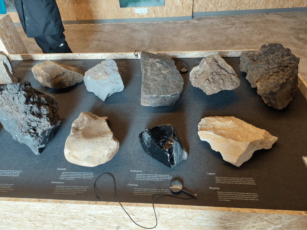
At the Visitor Centre of Snæfellsjökull National Park, specimens of several different rock types found in Iceland are on display. Although Iceland is built predominantly of countless layers of basaltic lava, many other rock types also occur. Just as basalt differs from peridotite, which represents the Earth’s upper mantle, the other rock types have formed through different magmatic and geological processes.

Rock types on display.

In many cases, the cooling history of the magma is the most obvious factor controlling the final rock type. Rapid cooling, particularly beneath glaciers or in water, may produce volcanic glass and palagonite, while slow cooling beneath the surface allows coarse-grained rocks such as gabbro to crystallize. Rhyolite is much richer in silica (SiO₂) than basalt, and if rhyolitic magma cools extremely rapidly before crystals can form, it solidifies as obsidian.

This is a very informative exhibition and is highly recommended for anyone interested in Icelandic geology.

Uncategorized

Geometric Relationships between the Ring of Fire, Antarctica, and Iceland

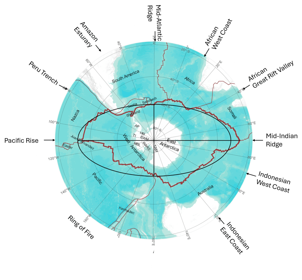
Viewed from the South Pole, the global system of plate boundaries reveals several striking geometric relationships between Antarctica, the Ring of Fire, and Iceland, as shown here:

Antarctica, the Ring of Fire, and Iceland shown in their geometric context.

The following observations summarize these relationships.

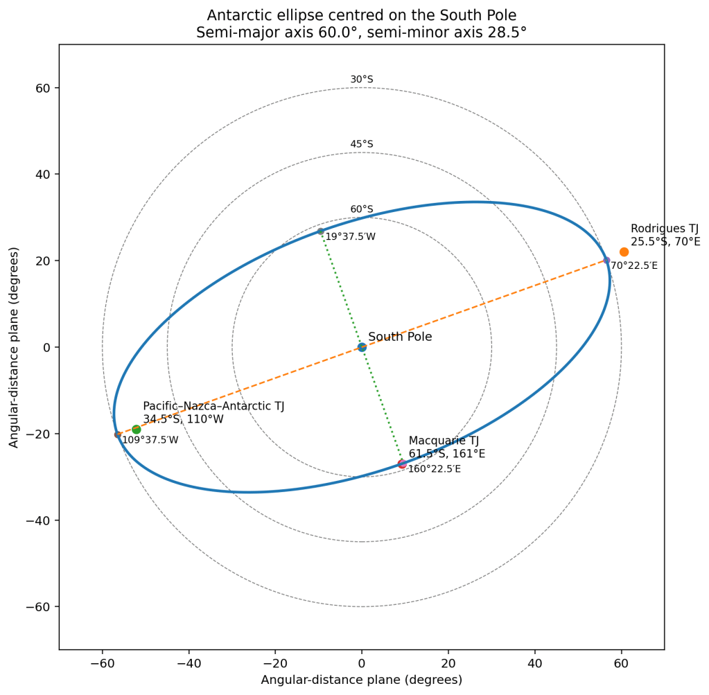
  1. The Antarctic Plate can be approximated by an elliptical shape. Its minor axis extends from 60°S, 160°22.5′E to 60°S, 19°37.5′W, while its major axis extends from 45°S, 70°22.5′E to 45°S, 109°37.5′W.
  2. These axes correspond closely with major plate-boundary systems. The major axis aligns with the Mid-Indian Ridge and the East Pacific Rise, whereas the minor axis follows the Mid-Atlantic Ridge and the western Pacific subduction system.
  3. The Ring of Fire can likewise be represented by an ellipse whose minor axis crosses that of Antarctica at 64°S, 160°22.5′E. The opposite end extends through the equator and is found within the Yellowstone region.
  4. The south coast of Iceland is located approximately the same angular distance north of the equator as the edge of the Antarctica Tectonic Plate boundary (sea floor) is south of it. Its overall elliptical geometry has the same orientation, with its minor axis lying along the longitude of 19°37.5′W.
  5. The southern end of the Ring of Fire coincides with the point where an equatorial mantle convection-roll division (red line) reaches the Antarctic Plate. From there, the Antarctic segment of the Ring of Fire continues toward the endpoint of another convection roll (90° apart), where it intersects the Antarctic major axis.
  6. The resulting geometry is consistent with the Ring of Fire extending between the equatorial convection-roll division points beneath eastern Indonesia and the west coast of South America. It coincides with the main deviation of the elliptical form of the Antarctic Tectonic Plate.
  7. The illustration is schematic and is not drawn to scale, since it represents relationships on a spherical Earth using a two-dimensional projection.

The purpose of this figure is to illustrate the geometric relationship between the global systems of mid-ocean ridges and subduction zones. In particular, it emphasizes that the Mid-Atlantic Ridge and the western Pacific subduction system occupy opposite sides of the same great-circle plane.

Several important features are intentionally omitted for clarity. These include the subduction system along the west coast of South America, the inner boundary of the Ring of Fire, the San Andreas Fault in California, and the Alpine Fault of New Zealand. Each of these plays an important role in the overall tectonic framework but would unnecessarily complicate the present illustration.

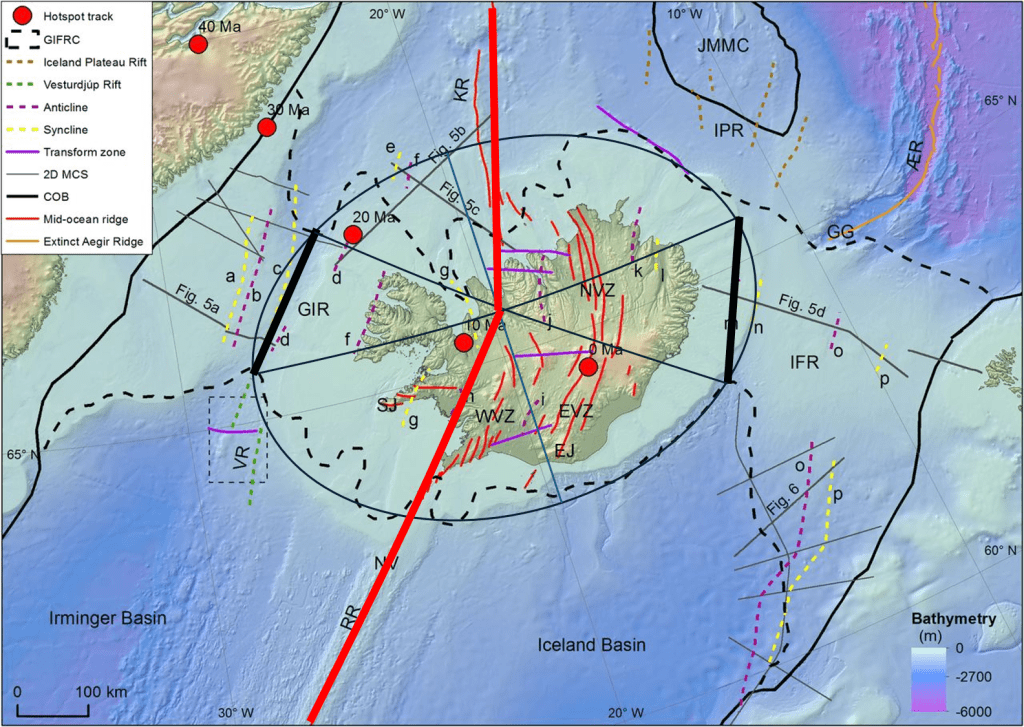
For reference, it may be helpful to compare the upper illustration with the more conventional one below. The Greenland–Iceland–Faroe Ridge Complex (GIFRC) is another manifestation of the symmetry around the 19°37.5′W axis of longi

Iceland with Central Latitude 19°37.5′W

The symmetry around the axis is obvious. A bit more complicated version below:

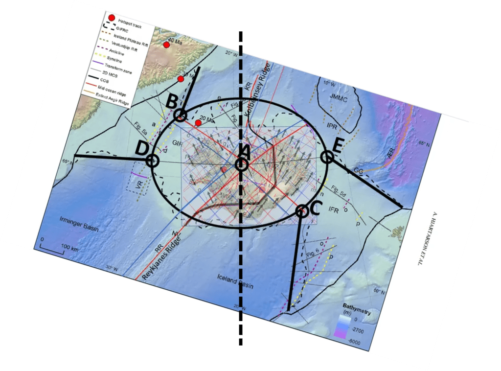
This shows how the two ridges are symmetrical around the Icelandic abyss, with D and E being the end points of the major axis. B and C are also on the periphery of the abyss, on the end points of the same convection roll. https://www.lyellcollection.org/doi/full/10.1144/sp447.14

Extrapolating the mid-ocean ridges, showing that they meet at the central point of the elliptical form of the Icelandic plateau, and marking the divisions of the Greenland and Faroe Ridges respectively, also contributes to realizing the symmetrical aspect of the structure as a whole.

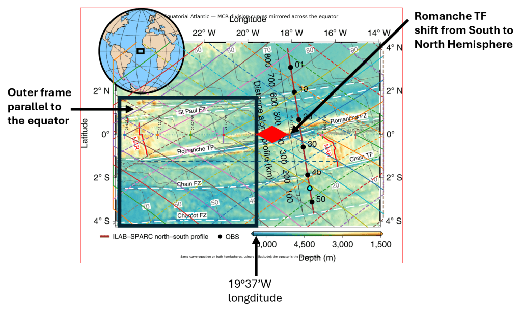
Conditions along the equator around 19°37.5′W

How Antarctica is facing the longitude of 19°37.5′W.
Minor axis of Antarctica and Iceland connected through 19°37.5′W.
The elliptical mathematically derived form of the Antarctican Tectonic Plate.
Uncategorized

Öxarárfoss – A Man-Made Waterfall Illustrating Rifting in Iceland

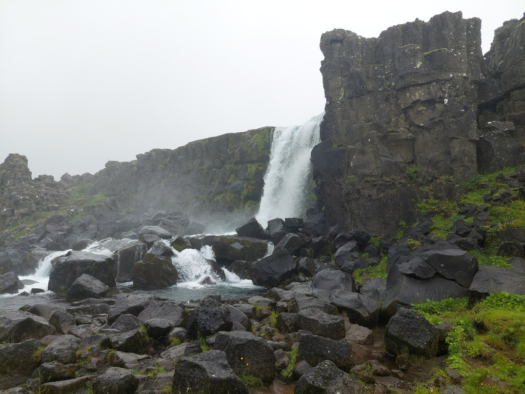
Öxarárfoss cascades over the edge of the North American Plate.

Öxarárfoss

Although it appears completely natural, the waterfall is actually man-made. The course of the Öxará River was deliberately diverted so that it would flow through the site of the Althing, Iceland’s ancient parliament, which was held nearby in the Þingvellir Rift Valley.

According to Haukdælaþáttur, the Öxará River was diverted into Almannagjá, from where it flowed through the assembly site at Þingvellir, providing a reliable supply of fresh water for the thousands of people and horses who gathered at the Althing each summer. The General Assembly lasted for two weeks, beginning at the end of June, every year from AD 930 until 1798. In 1799, it was transferred to Reykjavík.

The Þingvellir Rift Valley was formed by extensional forces as the North American and Eurasian plates move apart. But how do the plates actually move?

Modern GPS measurements are made using the International Terrestrial Reference Frame (ITRF), a global coordinate system that allows scientists to measure the positions and motions of points on the Earth’s surface with millimetre accuracy.

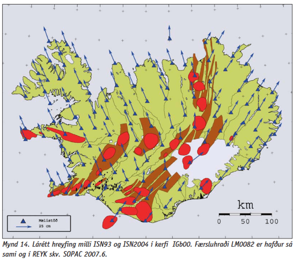
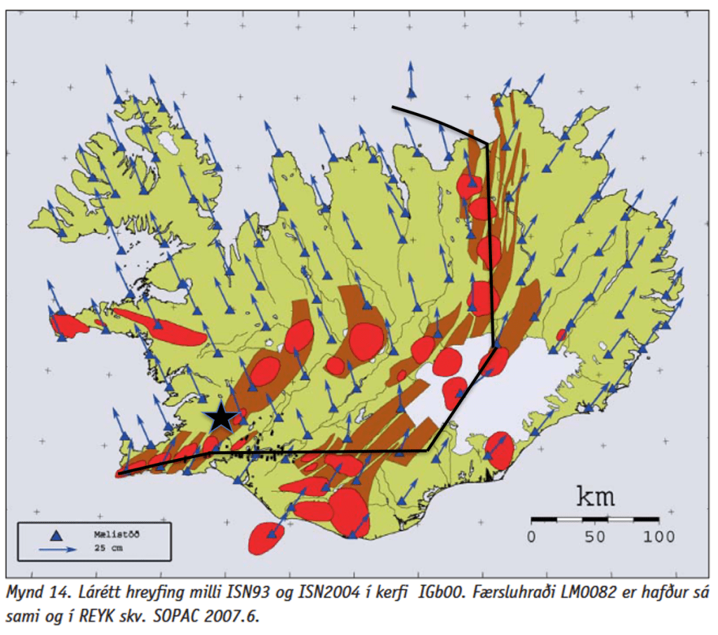
GPS surveys carried out in 1993 and 2004 showed that Iceland as a whole moves primarily northward in the ITRF reference frame. The western part of the country, resting on the North American Plate, moves toward the northwest, while the eastern part, on the Eurasian Plate, moves toward the northeast. Because both sides have a northward component of motion, the island itself drifts northward, while at the same time the two plates gradually move away from each other.

The original GPS data show both northward motion and rifting.

The relative spreading rate across Iceland averages about 18–20 millimetres per year, although it varies somewhat between different volcanic zones. At Þingvellir, this extension is accommodated by repeated earthquakes and movement along normal faults, gradually widening the rift valley. Individual earthquakes can produce sudden offsets of a few centimetres to several decimetres, while the long-term plate motion amounts to only a few centimetres per year.

Star shows approximate location of Öxarárfoss, north of the main division line.

The northward component of Iceland’s motion has received relatively little attention in the geological literature compared with the more widely discussed process of plate separation. This is understandable, as scientific understanding develops gradually, and established models often remain the primary framework for interpreting new observations. As more high-precision GPS measurements become available, they provide an opportunity to further examine the significance of Iceland’s overall northward motion and its relationship to the opening of the rift zones.