
According to the USGS, six major geyser regions can be identified in the world: Iceland, Yellowstone in the United States, the Valley of Geysers in Kamchatka, the Taupō–Rotorua region of New Zealand, El Tatio in Chile, and Lake Bogoria in Kenya.
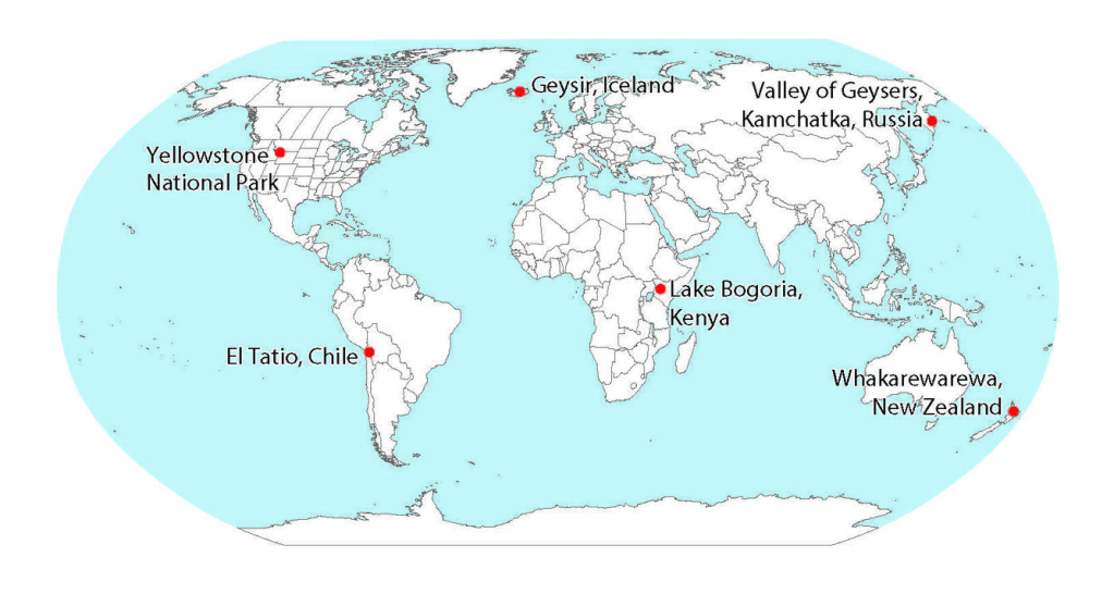
https://www.usgs.gov/media/images/map-showing-locations-major-natural-thermal-geyser-fields
For first comparison:
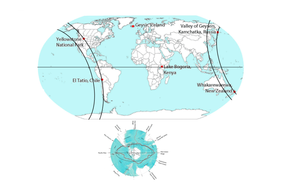
Iceland on minor axis, Lake Bogoria on the equator within Great Rift Valley.
Note that 90° separate Geysir and Yellowstone, and Geysir and the Valley of Geysers.
Geysers are rare because their formation requires a particular combination of geothermal heat, groundwater, permeable fractures, and a confined underground plumbing system in which water can become superheated before erupting at the surface.
According to the geometric interpretation presented here, the locations of all six major geyser regions can be related to prominent axes, ellipses, and major tectonic divisions shown on the map below.
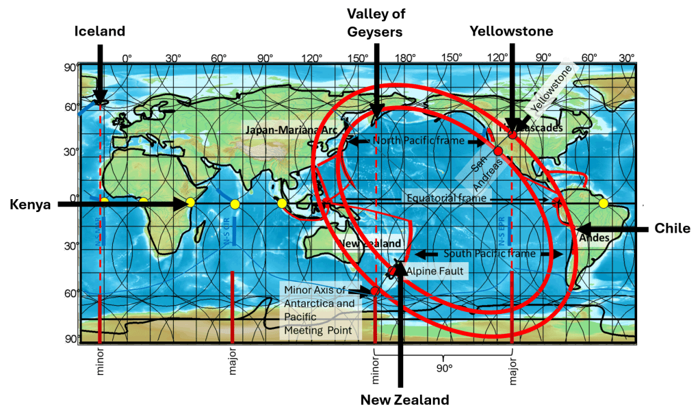
Iceland, Yellowstone, and Kamchatka all lie in direct continuation of the principal axes of the Antarctic ellipse. New Zealand is located near the intersection of the minor axis of the Ring of Fire and its inner elliptical form. Kenya is associated with the Great Rift Valley of Africa, close to the Equator, while El Tatio in Chile lies on the outer rim of the elliptical form of the Ring of Fire. Thus, all six of the world’s most prominent geyser regions can be related to the principal geometric features described here.
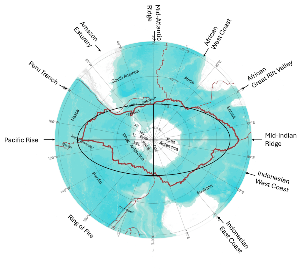
In the case of Iceland, the accuracy level is tremendous:
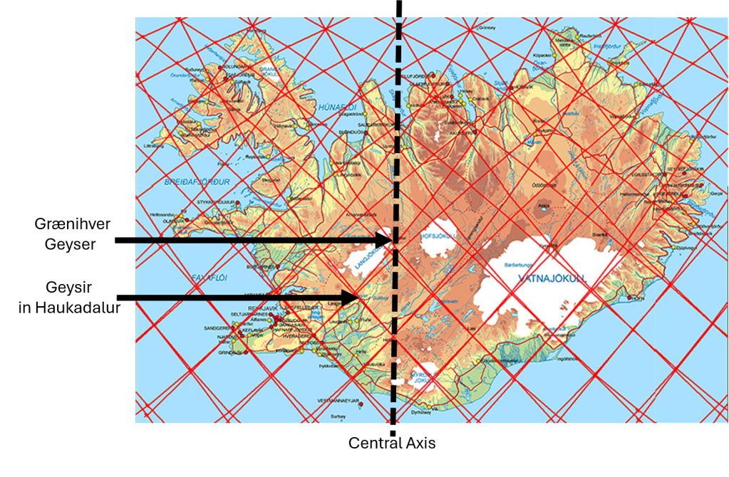
1. Iceland – Geysir and Strokkur
Iceland contains one of the classic geyser regions of the world. The best-known examples are Geysir and Strokkur in Haukadalur. Strokkur erupts frequently, while the activity of Geysir has varied considerably through historical time.
The Icelandic geothermal systems are associated with intense volcanism, abundant groundwater, fractured volcanic rocks, and a high geothermal gradient. Water can circulate downward through fractures, become heated at depth, and rise again. In a geyser, restrictions within the underground conduit allow pressure to build until part of the water suddenly flashes into steam, producing an eruption.
Within the geometric framework shown here, Iceland lies in the direct continuation of the minor axis of the Antarctic ellipse. The continuation of this axis extends northward through the Atlantic region towards Iceland.
2. Valley of Geysers, Kamchatka
The Valley of Geysers in Kamchatka, Russia, is one of the largest and most concentrated natural geyser fields in the world. It contains numerous geysers, hot springs, steam vents, and other hydrothermal features within a highly active volcanic environment.
Kamchatka is located along a major subduction zone, where the Pacific Plate descends beneath the region. This produces extensive volcanism and provides the heat necessary for powerful hydrothermal systems. Groundwater circulates through fractured volcanic rocks and is heated at depth, allowing geysers to develop where the underground plumbing has the appropriate geometry.
Geometrically, the Valley of Geysers is particularly significant because Kamchatka lies in the direct continuation of the minor axis of the Antarctic ellipse on the opposite side of the Earth from Iceland. Thus, Iceland and Kamchatka are associated with opposite extensions of the same principal axis.
3. Yellowstone, United States
Yellowstone National Park contains the greatest concentration of active geysers in the world. Famous examples include Old Faithful, Grand Geyser, Castle Geyser, Beehive Geyser, and Steamboat Geyser.
The Yellowstone hydrothermal system is powered by an exceptionally large volcanic and geothermal system beneath the Yellowstone Plateau. Rainwater and snowmelt penetrate deeply into fractured rocks, where they are heated and subsequently rise through complex networks of fractures and conduits. In geysers such as Old Faithful, the shape of the underground reservoir and conduit permits pressure to accumulate and produces repeated eruptions.
Within the geometry examined here, Yellowstone lies in the direct continuation of the major axis of the Antarctic ellipse. This places one of the world’s most important geothermal and geyser regions along another principal axis defined by the Antarctic geometry.
4. New Zealand – Taupō and Rotorua
New Zealand contains several major geothermal areas, particularly within the Taupō Volcanic Zone, including the Rotorua and Whakarewarewa geothermal fields. Pohutu Geyser is one of the best-known active geysers in the region.
The Taupō Volcanic Zone is characterized by active volcanism, large caldera systems, abundant fractures, and powerful hydrothermal circulation. Hot groundwater rises through volcanic rocks and produces geysers, hot springs, mud pools, and steam vents. Some historic geysers in New Zealand have changed or disappeared as a result of natural changes and human use of geothermal groundwater.
The position of the New Zealand geyser region is especially noteworthy in the present model. It lies on the minor axis of the Ring of Fire, close to the point where this axis crosses the inner ellipse of the Ring of Fire. The geyser region therefore occurs at an important geometric intersection within the circum-Pacific system.
5. El Tatio, Chile
El Tatio, in the high Andes of northern Chile, is one of the world’s major geyser fields. It contains numerous geysers, hot springs, fumaroles, and steaming geothermal pools. Individual eruptions are generally smaller than those of the largest geysers in Yellowstone or Iceland, but the number and concentration of geothermal features make El Tatio exceptional.
The heat source is related to Andean volcanism above the subduction zone along the western margin of South America. Water circulating through fractured rocks is heated by the volcanic geothermal system before returning to the surface.
In the geometry presented here, the Chilean geyser region lies on the outer margin of the Ring of Fire. Its position therefore corresponds directly with the major circum-Pacific tectonic and volcanic boundary.
6. Lake Bogoria, Kenya
The geothermal region around Lake Bogoria in Kenya contains hot springs, steam vents, and numerous small geysers. Although many of these geysers are considerably smaller than Geysir, Strokkur, or the major Yellowstone geysers, they operate according to the same basic hydrothermal principles.
Lake Bogoria lies within the East African Rift System, where the continental lithosphere is being stretched and fractured. This tectonic setting allows heat and fluids to rise relatively close to the surface and produces extensive volcanic and geothermal activity.
Its geographic position is particularly important in this comparison. The Lake Bogoria geyser field lies very close to the Equator and directly within the Great Rift Valley. It therefore represents the sixth major geyser region at the intersection of a major continental rift system with the equatorial zone.
Geometric Relationship of the Six Geyser Regions
The six major geyser regions occur in very different geological environments. Iceland is associated with an oceanic spreading system, Kamchatka and Chile with subduction-related volcanism, New Zealand with an active volcanic and plate-boundary region, Yellowstone with a major continental volcanic system, and Kenya with continental rifting. Nevertheless, all require the same fundamental conditions for geyser formation: a strong heat source, groundwater, fractured and permeable rocks, and an underground conduit system capable of retaining pressure.
When their geographic positions are compared with the geometry shown on the map, an additional pattern appears:
- Iceland lies on the northern continuation of the minor axis of the Antarctic ellipse.
- Kamchatka lies on the continuation of the same minor axis on the opposite side.
- Yellowstone lies in the continuation of the major axis of the Antarctic ellipse.
- New Zealand lies on the minor axis of the Ring of Fire, where it intersects the inner Ring of Fire ellipse.
- El Tatio in Chile lies along the outer margin of the Ring of Fire.
- Lake Bogoria in Kenya lies at the Equator within the Great Rift Valley.
All six locations are marked on the map below. The comparison is therefore not based only on the presence of geothermal activity. It shows that the world’s principal geyser regions occupy specific positions in relation to the major geometric and tectonic structures considered in this study.
help explain the locations of these major geyser regions.
The geometric relationships between the major geyser regions can be divided into several partly overlapping groups. It is important not to treat all of them as the same type of correspondence, because some are close point-to-line matches, while others involve larger tectonic or volcanic zones.
Iceland, the Valley of Geysers in Kamchatka, and Yellowstone form one group related to the geometric framework derived from the Antarctic Plate and the equatorial divisions. Geysir in Iceland is particularly interesting because it is not located directly on the principal axis at 19°37.5′W, but close to a subdivision line half a 1.5° interval farther west. This theoretical line lies at 20°22.5′W, while Geysir is at about 20°18′W. The difference is only about 0.075°, corresponding to roughly 4 km at this latitude. Thus, Geysir can be regarded as a close point-to-line correspondence within the subdivision system rather than as a direct match with the principal axis itself.
The Valley of Geysers and Yellowstone are also related to the Antarctic-derived geometry, but they have an additional and independent-looking relationship with the geometry of the Pacific Ring of Fire. In this second system, four major geyser regions occupy characteristic positions along the inner and outer margins of the Ring of Fire.
The Valley of Geysers in Kamchatka lies along the inner boundary of the Ring of Fire geometry. New Zealand, another of the world’s major geyser regions, is likewise associated with the inner boundary. On the opposite side of the geometric pattern, Yellowstone lies close to the outer boundary, while El Tatio in Chile is also located along the outer boundary.
This produces a striking two-by-two arrangement:
| Inner boundary | Outer boundary | |
|---|---|---|
| Northern sector | Valley of Geysers, Kamchatka | Yellowstone |
| Southern sector | New Zealand | El Tatio, Chile |
A further relationship is superimposed on this arrangement. New Zealand and Yellowstone are positioned in relation to the minor axis of the Ring of Fire ellipse. They are therefore not merely two geyser regions situated on different margins of the same geometric form; they also define, or lie close to, one of its principal axes.
Yellowstone and the Valley of Geysers are consequently of particular interest because they belong to both geometric groups. The Valley of Geysers is related both to the Antarctic-derived framework and to the inner boundary of the Ring of Fire. Yellowstone is related to the Antarctic framework, the outer boundary of the Ring of Fire, and the minor-axis geometry of the Ring of Fire. The recurrence of the same exceptional geothermal regions in more than one independently defined geometric relationship is more significant than a simple comparison of individual coordinates.
Kenya provides a different type of correspondence. Lake Bogoria lies very close to the equator within the Kenya Rift, which forms part of the eastern branch of the East African Rift System. The relevant geometric division also passes through the eastern rift system. Here the correspondence should therefore not be described as a geyser lying exactly on a single line. Rather, the subdivision line corresponds with a major tectonic zone, and the geyser field occurs within that same zone.
Iceland has a related connection with the equatorial subdivision system. Its major geothermal field at Geysir lies close to a longitude derived from one of the equatorial division points. In this sense, both Iceland and Kenya illustrate how the equatorial division system may correspond with major rifting and geothermal environments, although the geological expression is very different in the two regions.
These relationships can therefore be summarized as three overlapping geometric patterns:
- Antarctic and equatorial geometry: Iceland – Valley of Geysers – Yellowstone, with Kenya providing an additional connection through the equatorial division and the East African Rift.
- Inner and outer Ring of Fire geometry: Valley of Geysers – New Zealand on the inner boundary; Yellowstone – El Tatio on the outer boundary.
- Minor axis of the Ring of Fire: New Zealand – Yellowstone.
The comparison is complicated by the fact that geyser regions differ greatly in size and geological setting. Geysir in Iceland can be compared quite precisely with a longitude, whereas Yellowstone is a very large volcanic and hydrothermal system, and Lake Bogoria is best understood in relation to an entire rift zone. For this reason, the significance of the pattern should not be judged solely by measuring the distance of each geyser from a single theoretical line. The more relevant question is whether the world’s most prominent geyser regions repeatedly occupy characteristic positions within a geometric framework that was defined independently of the geysers themselves.


