
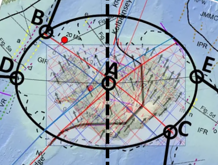
A striking feature of the Icelandic plateau is its broadly elliptical outline. The ellipse discussed here has its centre at approximately 65.600°N, 19.625°W. Its major axis is oriented exactly east–west along latitude 65.600°N, extending from approximately 27.300°W in the west to 11.950°W in the east. Its minor axis extends from approximately 63.000°N in the south to 68.200°N in the north.
Map base: https://www.researchgate.net/publication/316330629_The_Greenland-Iceland-Faroe_Ridge_Complex
Using longitude λ and latitude ϕ, the ellipse is defined approximately by:
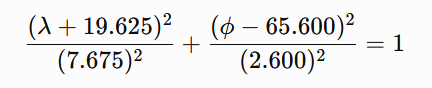
where λ denotes longitude, with western longitudes expressed as negative values, and ϕ denotes latitude.
The shape is particularly clear in the southeastern part of the Icelandic shelf, where relatively little later tectonic disturbance appears to have modified it. The most significant deviations occur in the northern sector, particularly around the Kolbeinsey Ridge, where younger spreading processes have substantially reorganized the crust. On geological and bathymetric maps, however, the elliptical geometry remains conspicuous. Of particular interest is that geological boundaries between the Icelandic part of the Greenland–Iceland–Faroe Ridge Complex and the adjoining ridge segments appear in places to follow the elliptical outline itself.
A stretched continental-crust interpretation
The geometry becomes especially interesting if the hypothesis proposed by Foulger and others is adopted as a working assumption: namely, that substantial amounts of stretched continental crust may remain beneath Iceland and parts of the Greenland–Iceland–Faroe Ridge Complex.
In such a model, Iceland would not consist exclusively of anomalously thick oceanic crust generated by excessive mantle melting. Instead, an older continental crustal component may have been progressively stretched, thinned, intruded by magma and covered by basalt during the opening of the North Atlantic.
If the remaining continental component beneath Iceland is approximately 20 km thick, whereas the original crust may have been 35–40 km thick, the crust must have undergone considerable areal extension. A simple volume-conservation calculation suggests that the original area could have been roughly one-half of the present affected area if the original crust was about 40 km thick.
The important point, however, is that the original block need not have been circular. It was probably elongated, because it represented part of the continental material being divided as Greenland separated from Europe. Its original structural connections would therefore naturally have extended toward Greenland on one side and toward the Faroe region on the other.
The Icelandic ellipse as a deformation envelope
The Icelandic ellipse should therefore not necessarily be interpreted as the original outline of a single continental fragment. A more plausible possibility is that it represents the finite deformation envelope of a wider zone of stretched continental crust.
The original continental material may have formed an irregular or elongated block, while long-term extension, lower-crustal flow, repeated rift relocation and magmatic intrusion produced a much smoother final deformation field. Over tens of millions of years, deformation distributed through a hot and mechanically weak crust can become considerably more regular than the original structural boundaries.
This possibility is compatible with several elements of Foulger’s model, particularly distributed extension, unstable and migrating spreading axes, broad transfer zones and ductile lower-crustal flow. Foulger does not propose the Icelandic ellipse itself, but the physical processes invoked in that model provide mechanisms through which a broad and relatively smooth deformation envelope could develop.
East–west extension
The major axis of the ellipse lies precisely east–west along 65.600°N. Within the mantle-convection-roll model, this is also an important structural latitude. The line passes through the central part of the northern volcanic-zone system when measured from north to south and through the geometric centre of the shelf ellipse.
The principal crustal extension can therefore be considered primarily east–west. This does not mean, however, that all deformation or material transport must have occurred east–west. The geometry suggests that the principal extension and the directions along which deformation was distributed may be different.
A useful distinction can therefore be made between the principal direction of extension, which was east–west, and the broader distribution of deformation, which appears to have taken place along northeast–southwest and northwest–southeast trends. This relationship may be fundamental to understanding the overall form.
Mirror-symmetric mantle boundaries
Within the mantle-convection-roll model, the major boundary associated with the Reykjanes Ridge continues through the central region beneath Iceland. It follows a curved SW–NE trajectory. A second underlying boundary forms a geometrical mirror image of this structure.
Both pass through the central region of the Icelandic ellipse. These two oblique systems can be considered mirror-symmetric components of a larger deformation field. This is mechanically important because two equally strong oblique deformation systems of opposite orientation can cancel their net shear while reinforcing their extensional components.
Schematically, if one system contributes a positive shear component, +γ, and its mirror-symmetric counterpart contributes an equal negative shear component, −γ, the two shear components cancel:
+γ+(−γ)=0
The net shear is therefore zero. The combined strain field can therefore retain principal axes oriented exactly east–west and north–south even though the underlying structural boundaries themselves are oblique. This offers a possible explanation for an otherwise curious feature: the Greenland–Iceland–Faroe system trends obliquely across the region, yet the Icelandic shelf ellipse itself is not similarly rotated. Its principal axes remain E–W and N–S.
Connections toward the Faroes and Greenland
The southeastern side of the ellipse connects with the Faroe segment of the ridge. The connection begins close to the eastern end of the major axis, near 65.6°N, 11.9°W, and continues southwestward toward approximately 63.3°N, 15.2°W.
This connection crosses the underlying convection-roll system obliquely rather than following a single roll boundary. According to the convection-roll model, it spans approximately five adjacent convection-roll elements, each separated by about 1.5° in longitude. Because the connecting zone crosses them obliquely, however, its real length and width cannot simply be calculated as (5\times1.5^\circ). The number five describes the number of underlying mantle units involved, rather than a direct geographical distance.
A corresponding connection occurs northwest of the major axis toward the Greenland segment of the ridge. It similarly extends across approximately five convection-roll elements but lies north of the 65.600°N major axis. The two connections therefore form complementary components of the same system:
- a southeastern connection toward the Faroes;
- a northwestern connection toward Greenland.
The Icelandic region between them is considerably wider than either connecting zone.
Why does the Icelandic region widen so much?
This may be one of the most important mechanical questions. If the connections toward Greenland and the Faroes are relatively narrow, why does the central Icelandic deformation zone expand into a broad ellipse roughly 700 km across? The answer may lie in the difference between a transfer zone and the deformation domain receiving the strain.
The Greenland and Faroe connections need not themselves be as wide as the Icelandic ellipse. Instead, they may transmit stress and deformation into a central region where the crust is hotter, weaker and more heavily intruded by magma. Once deformation enters such a mechanically weak domain, it can spread laterally.
A simplified sequence would therefore be: narrow oblique connection → broad, mechanically weak crustal domain → distributed extension and lower-crustal flow → development of an elliptical finite-strain envelope.
In this interpretation, the ellipse does not reflect the width of a single fault or rift. It represents the cumulative region over which deformation has been distributed.
Geological asymmetry superimposed on geometric symmetry
An important feature is that the ellipse is not preserved equally well on all sides. The southeastern sector appears especially regular. The geological boundary between the Icelandic region and the Faroe segment also seems to follow the elliptical geometry particularly clearly.
The Greenland-facing side appears sharper, whereas the Faroe-facing transition is broader and less abrupt. This difference does not necessarily contradict an originally symmetric underlying system. The subsequent tectonic histories of the two sides were different.
The largest disturbance occurs north of the 65.600°N axis around the Kolbeinsey Ridge. Spreading was reorganized in this region after the decline of the Aegir Ridge, and younger volcanic and spreading systems developed. These processes could have modified or overprinted an older elliptical deformation boundary.
Thus a distinction can be made between: primary geometric symmetry, controlled by the deeper system, and: secondary geological asymmetry, produced by later rift relocation, volcanism and crustal accretion.
Symmetry in degrees rather than kilometres
Another unusual aspect of the ellipse is that its symmetry is expressed in geographic angular coordinates. It is exactly symmetric about 65.600°N in latitude and 19.625°W in longitude. However, the Earth is spherical, and one degree of longitude becomes progressively shorter toward the north. Consequently, although the ellipse is geometrically symmetric in degrees, its northern half is physically smaller than its southern half when measured in kilometres.
At approximately 63°N, one degree of longitude corresponds to about 50 km, whereas near 68°N it is only about 41 km. The same east–west angular width therefore represents a greater physical distance in the south than in the north. This is important within the convection-roll hypothesis because the proposed mantle system itself is defined by angular divisions of the Earth. If the underlying mantle organization follows fixed longitudinal and latitudinal intervals, symmetry in degrees rather than kilometres would be expected within that model. This is quite different from an ordinary local strain ellipse constructed in a Cartesian coordinate system.
A possible combined mechanism
The emerging working hypothesis can therefore be summarized as follows. An elongated remnant of continental crust remained between Greenland and Europe during the opening of the North Atlantic. Beneath the Iceland region, the mantle-convection-roll system imposed a geometrically organized set of boundaries.
The principal crustal extension occurred in the east–west direction. At the same time, deformation was transmitted diagonally through two approximately mirror-symmetric systems extending toward Greenland in the northwest and the Faroes in the southeast. Because the two oblique systems are mirror-related, their shear components could largely cancel at the scale of the entire region while their extensional components reinforced one another. This allowed the principal axes of the cumulative strain field to remain east–west and north–south.

Within the Iceland region, hotter and weaker continental crust allowed deformation to spread laterally far beyond the widths of the narrower connections to Greenland and the Faroes. Ductile lower-crustal flow, repeated movement of spreading axes and extensive magmatic intrusion may have further smoothed the deformation field. The result could have been a broad, approximately elliptical finite-strain domain.
The Faroe and Greenland ridge segments would then represent narrower continuations of this larger crustal system rather than structures having the same width as the Icelandic central region.
Later tectonic reorganization, especially the development of the Kolbeinsey Ridge, subsequently disturbed the northern part of the original geometry. The most important observation is therefore not merely that the Icelandic shelf is approximately elliptical. It is that the geological boundaries, the central east–west axis, the connections toward Greenland and the Faroes, and the deeper mantle geometry proposed by the convection-roll model appear to form parts of the same symmetric system.
If the continental-crust interpretation is correct, the Icelandic ellipse may record the cumulative deformation of an old continental fragment whose extension was controlled not by a single rift axis, but by a wider and geometrically organized mantle deformation field.
The elliptical outline is particularly evident when compared with the geological and structural maps presented by Hjartarson et al. (2017). Their subdivision of the Greenland–Iceland–Faroe Ridge Complex shows distinct boundaries between the Icelandic shelf and the adjoining Greenland–Iceland and Iceland–Faroe ridge sectors. In particular, the southeastern geological boundary closely follows the elliptical outline described here. The elliptical interpretation itself is not proposed by Hjartarson et al.; it is introduced here as a geometric interpretation of the mapped structures.
The article: Hjartarson, Á., Erlendsson, Ö. & Blischke, A. (2017). The Greenland–Iceland–Faroe Ridge Complex. Geological Society, London, Special Publications, 447, 127–148. DOI: 10.1144/SP447.14.
https://www.researchgate.net/publication/316330629_The_Greenland-Iceland-Faroe_Ridge_Complex


