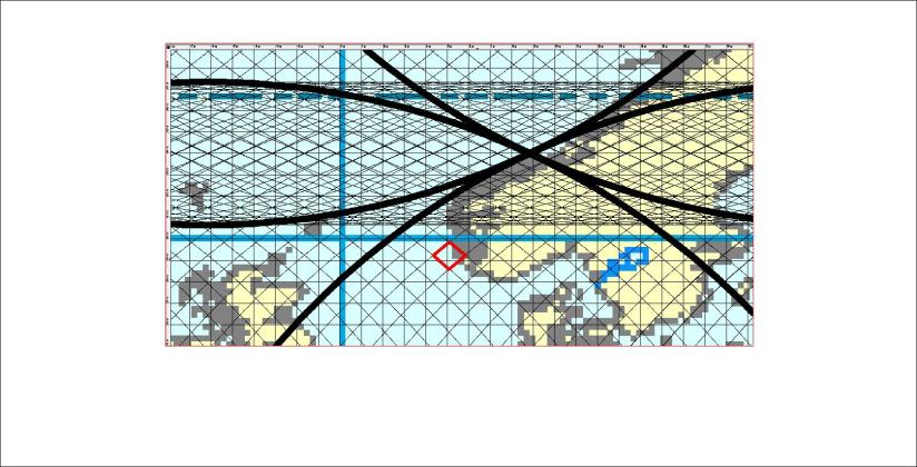
The answer is of course both yes and no. It is yes because volcanic eruptions have been predicted many times correctly. Still, nature takes us by surprise all the time. With a model of convection rolls it will be possible to predict activity level of different volcanic sites and areas in the future. A key to that is the so called V-shaped ridges of Reykjanes peninsula, because there we see activity propagating along the ridge to the SW. Similar movement of activity centers along other lines should be found and thereby additional activity level at certain locations can be predicted.
Category: Uncategorized
Which volcano will erupt next in Iceland?
For the last four decades, about one eruption has occurred every two years in Iceland. Still we know nothing about the next one, Where, when and how questions can not be answered. Something new is surprising us now and then, like Öræfajökull now melting the ice at its top. Rather big earthquakes at Bárðarbunga bring it to our attention again and again. Let us have a look at the list of some of the suspected volcanic sites:

Recently earthquakes shook Skjaldbreið and it seemed like magma was entering the crust a few kilometers below the mountain. Hekla has changed its rhythm, but the mountain has expanded more than before the last eruption. Katla is a mystique: When will the next large scale flood happen? Bárðarbunga and Grímsvötn are going through a period of activity. Actually Bárðarbunga is the most likely candidate for the next eruption. It is also a very interesting case to study, as it is in the middle of a polygon, showing itself to be a caldera with the function of feeding the spreading zone with magma forming huge dykes to cope with the tectonic drift. Askja can in turn be affected by the dykes propagating from Bárðarbunga. Recently even Kverkfjöll became a suspect when there were signs of eruption found in rivers flowing from that area. And finally, magma must be responsible for the melting of ice at the top of Öræfajökull. We just do not know the details of the intrusion below the mountain.
South Iceland Seismic Zone Polygon
I mentioned the SISZ earlier, as it is one of the clearest examples of polygons marked by the mantle convection cells. The balanced conditions within the ductile part of the tectonic plate lead to earthquake faults exactly in between the symmetrical lines around it to the NW, NE, SW and SE. The faults are therefore aligned NS.

In this way it becomes much easier to analyze every feature of earthquake zones of this kind. The reasons for pressure directions become clear. In this case, pressure is exerted from NE and SW. NS-faults are drawn with 715 meters interval along the 64th parallel.
The Vatnajökull Polygon – simplified
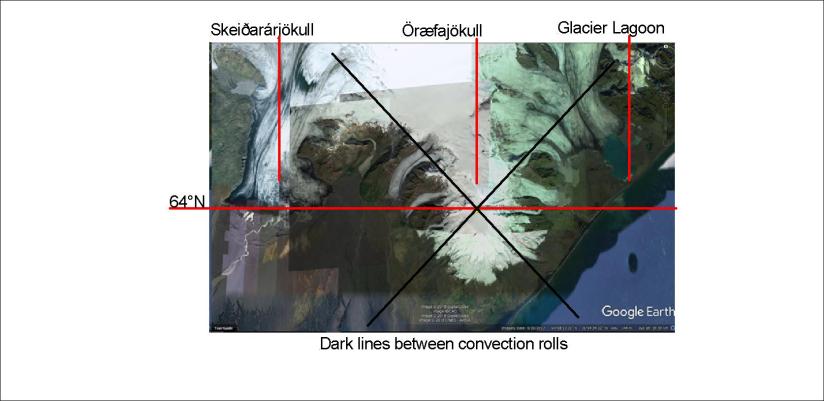
This can be called the Vatnajökull Polygon:

At three corners of the main polygon the mantle convection rolls form, there are very famous volcanic sites, Grímsvötn, Kverkfjöll and Öræfajökull. Esjufjöll are found close to the center of the polygon. But the polygon is very unlike the next polygons to the NW and W which are in a rift zone. The Vatnajökull Polygon is very active, but no rifting is taking place within it. The polygon should still move partly as a whole, and therefore activity at Bárðarbunga and especially Grímsvötn and Kverkfjöll might affect Öræfajökull. It is obvious how this polygon provides the main area for Vatnajökull. The line from Öræfajökull to the NE also marks the eastern edge of the glacier. So, the convection rolls far below give us a framework to explain the appearance of the wonder world of Vatnajökull.
Thingvellir – a rift valley
Lake Thingvallavatn and the western edge of the Thingvellir Rift Valley.
Thingvellir is Iceland’s no. 1 national park, with its history of the oldest national assembly still operating in the world and the rift valley forming due to tectonic drift. Those who study the tectonic plates thoroughly can see that the main division line according to measurable drift directions is found along the South Iceland Seismic Zone. Therefore, Thingvellir area does drift to the NW, but being located at the western edge of the West Volcanic Zone – which is a rift zone – it can be regarded as a continuation of the top of the Mid Atlantic Ridge along with other areas of the two rift zones of Iceland. The two plates of N-America and Eurasia are so large that taking the so-called Hreppar microplate into account is somehow trivial. To me, Thingvellir represent the division between Europe and America quite clearly. If the western edge is for sure the beginning of the N-American plate, then the other side of the rift valley can be represented as the Eurasian part of Iceland. Logical enough?