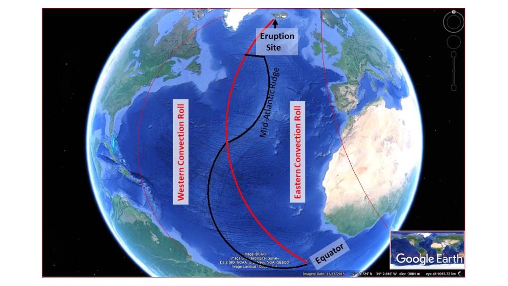
The approximately 5 cubic meters per second of lava, flowing on the ground of Reykjanes these days, represent huge forces of the Mid-Atlantic Ridge. The ascending magma is originated from convection rolls, which on the time scale of 100 million years have divided the continents and shaped the Atlantic Ocean, as can be learned about here: https://en.wikipedia.org/wiki/Mid-Atlantic_Ridge
The convection rolls responsible for this huge formation of the Atlantic Ocean, is also driving the mechanism behind the eruption at Fagradalsfjall on the Reykjanes Peninsula in Iceland. The outer limits of the convection rolls are marked here (approximately) with red lines.
The mantle rolls and the Mid-Atlantic Ridge.
The eruption site at Fagradalsfjall is pointed out. The ridge coincides with the lower mantle division line along the Reykjanes Ridge close to Iceland, and also at 32°N and equator.
The river Ölfusá flows in a remarkable zigzag pattern, either directly to the south or to the west. It can be explained by the fact that it flows through an earthquakes zone, which is aligned from east to west, and affected by individual earthquake faults, perpendicular to the comprehensive zone, and therefore oriented from north to south. Besides this, two volcanoes affect the flow, namely Hestfjall and Ingólfsfjall. Those volcanoes are located outside the West Volcanic Zone (WVZ), but appeared there all the same. Hestfjall is a shield volcano, and therefore the lava ascended through the weakness provided by a N-S trending earthquake faults. The same applies to the tuya of Ingólfsfjall. Shield volcanoes are formed in the same way as tuyas, but during ice-free periods, whereas a tuya forms under ice or water.
Here is a map, showing the river flow directions, exaggerated by superimposed blue forms:
Zizag pattern of Ölfusá River in South Iceland.
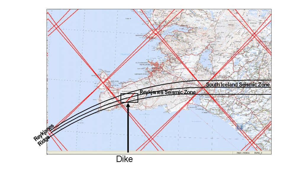
The South Iceland Seismic Zone shapes the area, both with the seismic activity itself, and by providing weakness for magma to flow to the surface at certain locations. The shield volcano of Skálafell is also shown. The silhouette of Skálafell resembles a house seen from the east, and it is said that Ingólfur, the first settler of Iceland, once built a house there, and therefore the mountain got this name. These relatively young volcanoes are all found along the 64th parallel, shown on the map, which is also the theoretic main division line between tectonic plates. The line then bends southwards when prolonged to the west along the Reykjanes Oblique Rift, and the current eruption at Fagradalsfjall on Reykjanes Peninsula is also related to that division line.
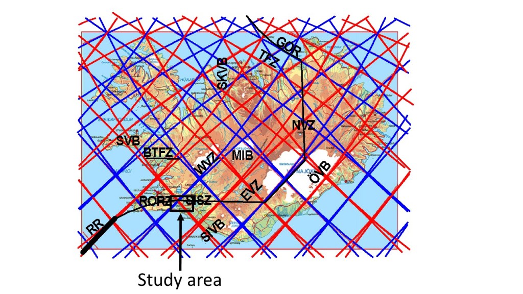
To clarify where the area is, please find it on this map below. The small, black square is found in between the South Iceland Seismic Zone (SISZ) and the Reykjanes Oblique Rift (RORZ).
The Golden Circle Tour is by far the most popular day tour in Iceland. The scenic areas are mainly Thingvellir, The Golden Waterfall and Geysir hotspring area. The travellers enjoy nice view on the way, such as of the mountain Ingólfsfjall, and probably regard it as extra scenery. But the mountain is a very interesting tuya, and should be inspected more closely. You can read about it here: https://en.wikipedia.org/wiki/Ing%C3%B3lfsfjall
The mountain has a NS-structure, just like other tuyas in Iceland. It has been shown that eruptions take place through NS-aligned earthquake faults, explaining the formations. Looking at the mountain from above, the resulting square form can be identified easily. The eruption at Fagradalsfjall of Reykjanes is of that category, so this has rewaken our interest in this type of volcanic activity, as shaped Ingólfsfjall.
Ingólfsfjall and the rivers Sog, Hvítá and Ölfusá.
At the eastern side of the mountain, two rivers meet, namely Sog and Hvítá. The Sog River flows from Lake Thingvallavatn at the olld National Assembly Site of Iceland, and Hvítá River has its origin in Langjökull Glacier, and does posess the Golden Waterfall. The name of the river, formed by the combination of those two, is Ölfusá. It can be noticed that Sog and Ölfusá together flow directly from north to south, due to the NS earthquake faults found in the area. Hvítá, on the other hand, follows the alignment of the volcanic zones at the meeting point.
Driving along the eastern slopes of Ingólfsfjall is therefore more interesting than may would think at first, remebering that Ingólfsfjall acts as a monument for the first settler of Iceland, Ingólfur Arnarson. The story says that his grave is found on the mountain. It is interesting that a similar story is found about Fagradalsfjall, the other tuya now erupting at Reykjanes, as the grave of Isólfur, the settler of that area more than a thousand years ago, is found on top of that mountain.
The latitude of 64°N is pointed out, as it is the central axis of the South Iceland Seismic Zone. The zone is aligned EW, about 70 km long, combined of around 100 NS-oriented parallel earthquake faults. Such faults mark the western and eastern sides of the mountain, direct the rivers, and are sources of geothermal activity in the area. The mountain is 4.5 kilometers wide from east to west, shaped altogether by seven parallel earthquake faults.
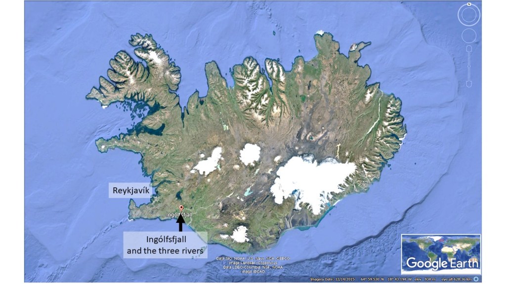
For orientation, Ingólfsfjall is here pointed out on a map of Iceland.
The location of Ingólfsfjall in Iceland.
The mountain Ingólfsfjall is found between the town Hveragerði, famous for geothermal activity, greenhouses and flowers, and Selfoss, the largest town within the Southern Lowlands area.
Volcanic eruptions have formed Iceland along with the tectonic drift. Magnetic anomalies have been mapped and analyzed, telling the story of how Iceland has evolved for millions of years. Grétar Ívarsson and others have shown this step by step. This topic is dealt with in the paper ‘Geology and geodynamics of Iceland’ by, R. G. Trønnes ( http://eduterre.ens-lyon.fr/thematiques/terre/islande/Geology%20and%20geodynamics%20of%20Iceland.pdf )
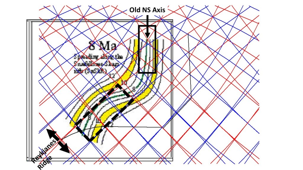
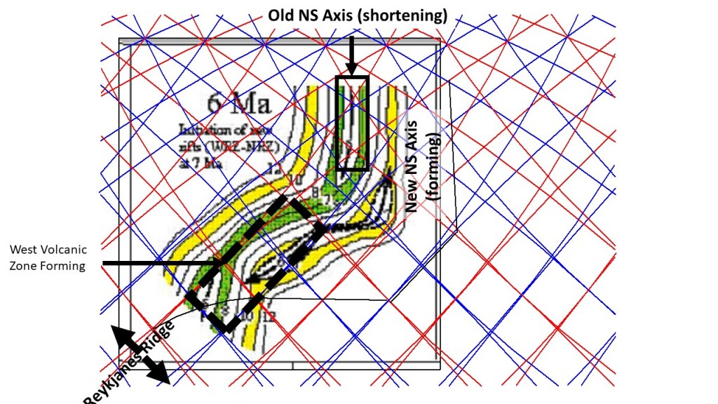
The first map shows the conditions prevalent, where you find Iceland today, 8 million years ago. By then, the structure of Iceland was simpler than today. The mid-ocean ridges were rather directly connected, and the magnetic anomalies were aligned regularly parallel to the mid-axis of the ridge.
Magnetic anomalies – 8 million years old axis.
The square with dotted lines indicates where the West Rift Zone was going to form. A NS-axis could be defined, similar to the one found to day within the North Volcanic Zone of Iceland.
Then the West Rift Zone of Iceland started to emerge. The West Rift Zone is a term combining the areas often referred to as the West Volcanic Zone and the Reykjanes Oblique Rift.
Magnetic anomalies – 6 million years old axis.
About 6 million years ago, the rift axis stopped spreading north of the 64th latitude. Rifting started farther to the east and the West Volcanic Zone started to form, offset from the Reykjanes Ridge. The rift zone cuts through older parallel anomalies east of the old axis from the NE, as the older ones were oriented NS. Therefore, the pattern of anomalies becomes more complex. At the same time, a new NS-axis started replacing the old one.
Magnetic anomalies – 4 million years old axis.
Now the West Rift Zone (WRZ) had developed withn the framed part. The new NS-axis had shifted eastwards, as it adds constantly material symmetrically to both sides.
Magnetic anomalies – 2 million years old axis.
Now, the new East Volcanic Zone starts to propagate to the south-west from the North Volcanic Zone.
Magnetic anomalies – as measured today.
Today, we see this pattern of magnetic anomalies in Iceland. As expected, they show the same characteristics of geological features as other types of mapping. Pointing out the site of the eruption taking place in Geldingadalir and Meradalir on the Reykjanes Peninsula of Iceland today, it can be easily understood that it is an important volcanic area. If you trace the maps one by one, it can be argued that this eruption is actually found at the spot from where all the development of the volcanic zones of Iceland started 8 million years ago, leading to the situation we learn about today!
The structure of the volcanic area now active in Iceland is quite fascinating. The base of Fagradalsfjall is diamond-shaped, and is formed within the earthquake zone of the Reykjanes Oblique Rift. The zone is bent, because it connects two different systems of the Reykjanes Ridge (aligned NE-SW) and South Iceland Seismic Zone (aligned E-W). The earthquake faults are oriented NS, all the same, because the pressure from NE and SW is undisrupted by the swayed structure of the plate boundary and the related tension and rifting process.
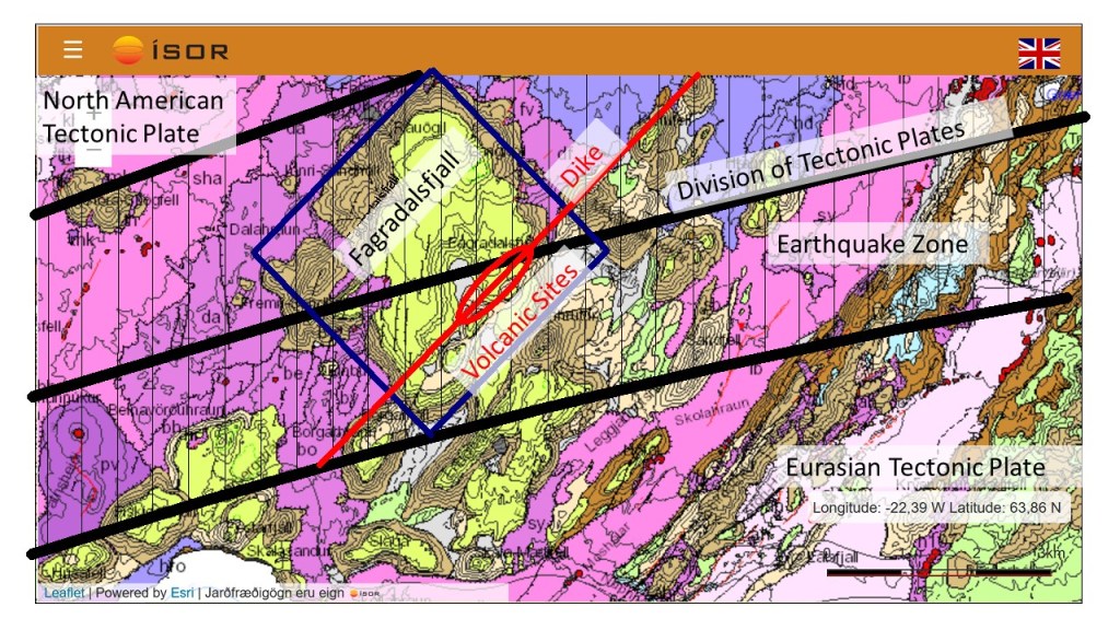
The geological settings around the volcanic sites of Geldingadalir. Map base from ISOR.
TThis map can be explained further: 1) Blue frame indicates the base of the tuya Fagradalsfjall. The sides are oriented N44°E and N44°W, because of the convection rolls underneath shaping the surface in various ways. 2) Thick black lines indicate the earthquake zone, connecting the South Iceland Seismic Zone and the Reykjanes Ridge. The middle line is in fact the division between the two tectonic plates of N-America and Eurasia. 3) Thinner NS oriented lines indicate location of earthquake faults within the zone. They have been mapped by many scientists for the last decades, for instance Páll Einarsson and Vigfús Eyjólfsson who I have referred to in other posts. The general layout here is extrapolated from their findings. 4) The red line shows the approximate location of the dike. It has the same orientation as the slopes of Fagradalsfjall, which in turn has the same orientation as the Reykjanes polygon of the convection rolls model. 5) The red ellipse indicates the sites of eruption. The erupting locations coincide with crossings between earthquake faults and the dike, as the magma can most easily make its way to the surface through the earthquake faults.
The earthquake faults form a pattern of dominantly NE-SW oriented fractures with en echelon arrangement on the surface, Farther down, they tend to become aligned closer to NS, as indicated on the map.
The end of the dike seems to be at the border line of the earthquake zone. All this harmony of nature becomes quite obvious once the eruption has started. Why do we not notice those things unless something happens, bringing more attention to the area?