An Overview
What if Earth’s interior behaves like a system of long, swaying rolls — nested currents that move heat and mass in a planetary circulation? This post explains a holistic model where deep, large rolls in the lower mantle couple to finer rolls in the upper mantle, how heat can flow both ways, why basalt may originate beneath subducting plates, and how the planet’s rotation and curvature set the geometry of everything from mid-ocean ridges to the Ring of Fire.
The Earth as a Layered, Moving System
Most readers know the Earth as a set of layers: crust, upper and lower mantle, outer core, inner core. But these layers are not passive shells. They exchange heat, mass, and momentum through organized flow. The mantle convection rolls model treats the interior as a nested system of rolls — long coherent cells in the lower mantle and smaller, faster rolls in the upper mantle that directly interact with the crust.
Large rolls operate at depth, slowly moving material between the core–mantle boundary and the base of the upper mantle. Above them, upper-mantle rolls commonly span roughly 1.5° of latitude (a practical scale for near-surface circulation) and are more responsive to lithospheric structure and localized stress. Together they make up a continuous circulation that links the deepest parts of the planet to its outer skin.
Heat Can Be a Two-Way Street
Classical descriptions emphasize heat escaping from the core toward the surface. The convection rolls model adds an important nuance: thermal radiation from radioactive elements found in upper layers heat the core. Rather than purely one-directional cooling, the interior operates with a dynamic thermal exchange — a feedback loop that helps sustain the system’s long-term behavior.
Where Basalt Really Comes From in Subduction Zones
The model revises the common view of arc magmatism. Instead of seeing basalt solely as a product of slab dehydration and consequent melting of the wedge above the slab, the convection rolls framework places the basalt source below the subducting plate. Deep upwelling associated with large rolls can rise beneath the slab and feed volcanism through both plates, making arc volcanism a surface expression of deeper roll-bound flows.
Rotation, Slab Dip, and Global Asymmetry
Earth’s rotation subtly modifies how descending slabs behave: westward-trending slabs are driven steeper into the mantle, while eastward-flowing slabs tend to be pulled out into shallower attitudes. This rotational influence produces systematic, global patterns in subduction geometry and has not been explicitly accounted for in simpler models of slab descent.
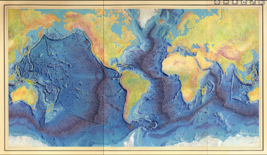
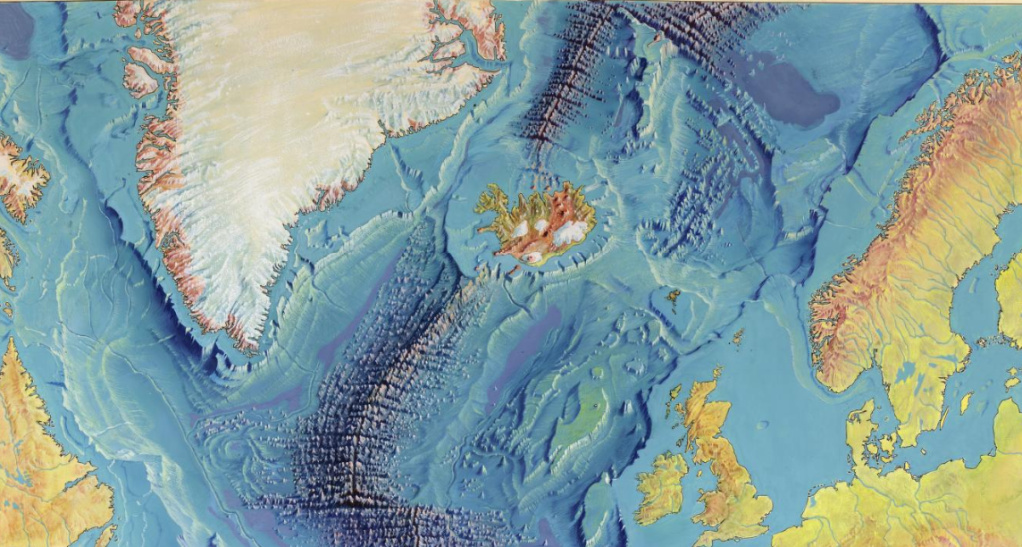
Ridges, Rolls, and a Global Geometric Pattern
Large mid-ocean ridges are not random. They align with the geometry of underlying rolls. Notably, the Reykjanes Ridge and Juan de Fuca Ridge follow the same formula and appear oriented 90° apart; by rotating one segment 90° they can be connected end-to-end to form a continuous upwelling track. The Mid-Indian Ridge also obeys the same relation. These systematic alignments support the idea that ridges are surface manifestations of deep convection boundaries.
The Curvature Problem — Why Rolls Sway and Why the Latitude of 32° Matters
One of the most important insights of the model is geometric: convection rolls “sway” because of Earth’s curvature. Imagine a roll whose overall horizontal flow is aligned perfectly north–south. On the spherical Earth, the east–west diameter of that roll (measured along a latitude circle) will vary with latitude. There exists a latitude where the east–west span of the roll equals the Earth’s radius when the roll is north–south aligned.
When you project latitude and longitude on a map with equal linear spacing (so that degrees of latitude and longitude represent equal lengths), a roll at that special latitude appears circular. Solving the geometric constraint for Earth gives the remarkable result that the latitude of exact north–south alignment is 32° N and 32° S. In other words, the roll geometry locks into a configuration at ±32° that allows a circular cross-section in that equal-length projection.
Why is this important? If the roll shapes are constrained by this curvature condition, then the entire system of rolls — their position and shape globally — can be derived from that constraint plus the roll spacing and boundary conditions. In practice this means there is a mathematical route to map every convection roll on Earth, leaving no gap in the global circulation. The calculation is nontrivial (a mathematical challenge involving spherical geometry and roll dynamics), but it yields a closed, self-consistent architecture: nested large rolls in the lower mantle and smaller 1.5° rolls in the upper mantle that tile the globe coherently. This solution was explored in the WGC 2020 paper and is a central pillar of the mantle convection rolls model.
A Planet-Wide Circulation System
One of the most intriguing implications of the convection rolls model is that it demonstrates how mantle material can circulate globally, not just vertically.
Because the rolls are continuous and curved along Earth’s spherical geometry, material can move both vertically and horizontally through the system. Starting from a point on the equator, an imaginary particle of mantle material could follow the flow paths around the planet and, after a full cycle, return to the same point.
This means that Earth’s interior is not a collection of isolated convection cells but a closed, interconnected circulation network. Over geological time, this circulation distributes heat and matter across the entire globe, linking distant regions in one coherent system.
Such continuous flow also provides a physical basis for the observed thermal balance of the planet. Global circulation allows heat to move in all directions — upward, downward, and sideways — maintaining a long-term equilibrium between core temperature and surface heat loss. In this way, the mantle convection rolls model not only explains motion but also the stability of Earth’s deep interior over billions of years.
The Gutenberg Layer: A Shared Zone Between Two Worlds
At the base of the mantle, around 2,900 km depth, lies the Gutenberg layer — traditionally described as the mantle-core boundary. Within the convection rolls model, this layer gains new significance.
Mathematically, it represents the intersection zone where the outermost part of the outer-core convection rolls meets the lowermost part of the lower-mantle rolls. Rather than being a simple boundary, it is a common zone shared by both systems — a transition and interaction region that couples two distinct convective domains.
This interpretation provides another alignment between mathematics and measurement: the calculated thickness of the intersection region in the model matches the observed thickness of the Gutenberg layer. It strengthens the plausibility of the model by showing how independent approaches — geometric derivation and seismic observation — converge on the same structural result.
The Gutenberg layer thus functions as a transfer zone, channeling heat and momentum from the core’s deep convection into the overlying mantle rolls. It marks the physical connection point in the great internal circulation engine, where deep energy exchange maintains the planet’s long-term thermal rhythm.
Also, how does deep, ductile mantle reach the surface through a brittle crust? Borrowing an idea from engineering — the Munroe effect (shaped-charge focusing) — the model argues that concentrated stress and heat can create focused upwellings or “jets” capable of piercing the crust. These focused pathways explain how mantle material can erupt or cool near the surface while the larger convection rolls remain intact.
The Ring of Fire as a Secondary, Mathematically Constrained Feature
From the roll geometry follow the major division lines between adjacent cells. Where several division branches intersect and curve around basins, an elliptical band of subduction and volcanism is produced — the Ring of Fire. In this model the Ring is not a single primary engine but a secondary feature dictated by the layout of roll boundaries. Key subduction loci (equatorial Indonesia, South America) and important continental tectonic centers (San Andreas, Yellowstone) fall out naturally from the geometry.
Toward a Unified, Testable Framework
Taken together, these ideas form a holistic portrait of Earth as a coherent, circulating system:
- Nested rolls (deep and shallow) set global and regional patterns.
- Heat flows both ways and can be focused into pathways that puncture the crust.
- Basaltic sources beneath subducting plates and rotationally modulated slab dips follow from the same dynamics.
- The spherical geometry of Earth forces roll shapes to sway and locks the system into a derivable global tessellation — with ± 32° as a key anchor.
- Circulation through the entire planet maintains long-term thermal balance and explains the core-mantle coupling at the Gutenberg layer.
This framework is intentionally predictive: ridge alignments, slab dips, arc positions, and anomalous volcanic centers are all observable consequences. The mathematical derivation and case studies are discussed in more detail in the WGC 2020 paper and the Stanford 2023 presentation.
References & Further Reading
- Comparing Large-Scale Geothermally Related Topographic and Bathymetric Features and the Mantle Convection Rolls Model, Stanford 2023.
- A Comprehensive Model of Mantle Convection Rolls, Proceedings World Geothermal Congress, 2020.