Blog

Uncategorized

Why Convection Rolls of the Mantle Form a Regular Pattern

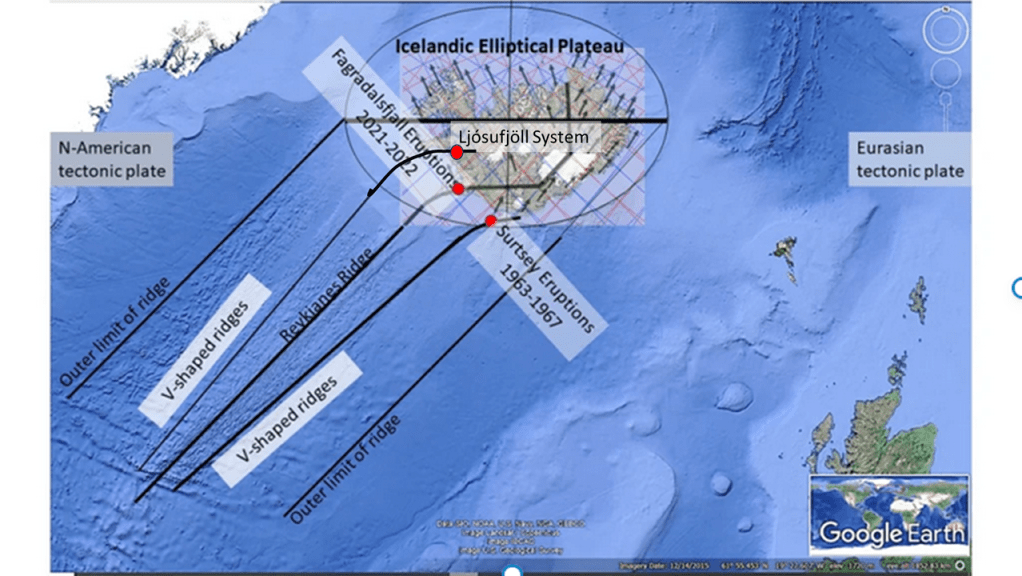
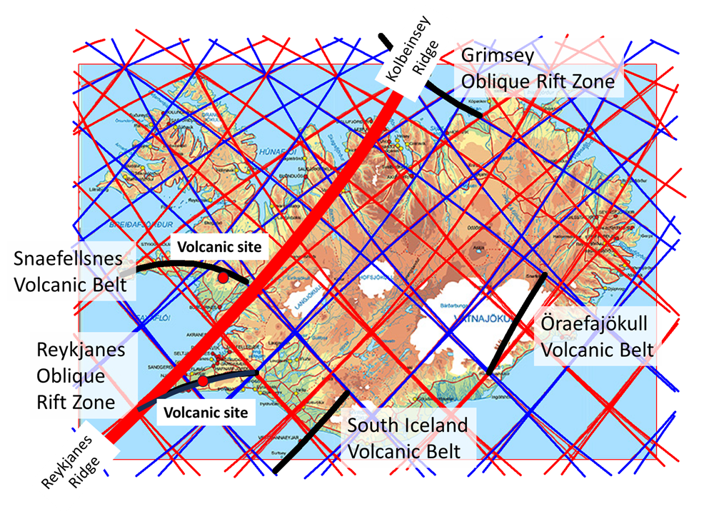
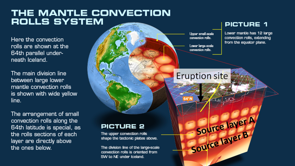
Convection rolls within the mantle have an adiabatic heat gradient, starting at the border between tectonic plate bottom and the layer below. Logically, the mantle must therefore as a whole be on the verge of being ductile and stagnant. A tectonic plate is 120 km thick, according to the defination that its lowermost border is where convection, or constant flow of mantle material, is found.

It has been found in laboratories, that if mantle material at this point (convecting but very close to becoming stagnant) does form convection rolls. As reality and experimental results are to be compared, especially if no other factors affecting real circumstances than used during experiment can be pointed out, inserting the outcome of experiment into known and measured circumstances is indeed a piece of work any scientist should undertake.

In this case it is easy, because the thickness of inner layers of Earth are known. Putting togherher the outcome of the experiments in laboratories, the logic of adiabadic thermal gradient, and knowledge about the depth of each layer, this is the outcome:

This is the basic picture of a section of convection rolls within the Earth. Inserting the results of experiments, fits exactly into measured environment.

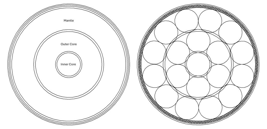
Most people recognize the core, mantle and crust, and some might notice the Gutenberg layer, also known as the core-mantle boundary or CMB. This is a beginning of a study described in the book found here on this webpage. Reading that book is of course more difficult than reading this short post, and most people do certainly not have time enough to read it. It can be said here, though, that all the implications have been worked out, and how the convection rolls form a 3D system within the Earth is thereby fully understood. In turn, it enhances our overall understanding of geology.

Uncategorized

V-shaped ridges, Surtsey, Fagradalsfjall and Ljósufjöll

The eruptions of Surtsey and Fagradalsfjall can be compared with the recent seismic activity of Ljósufjöll volcanic system at the roots of the Snæfellsnes Peninsula. The V-shaped ridges found on the Reykjanes Ridge also fit into that comparison.

All this activity is found to take place during a little more than half a century. Considering the central location of the Reykjanes Ridge, and the seismic zone associated with both the Reykjanes Oblique Belt and the Borgarfjordur West Lowlands Seismic Zone, it seems more and more logical that these areas can be compared in many ways. Here is another post:

.https://magicmagma.com/2022/09/17/similarities-between-fagradalsfjall-eruptions-2021-2022-and-surtsey-eruptions-1963-1967/

Uncategorized

Similarities between volcanic activity of Reykjanes and Snæfellsnes in Iceland

New seismic activity has been noticed at Snæfellsnes in Iceland. It can be compared with the present activity at Reykjanes where 10 eruptions have occurred since 2021.

The two volcanic sites, marked on the map, can be compared with the model of convection rolls related to the formation of the Reykjanes Ridge and Kolbeinsey Ridge. Together, they form the sections of the large Mid-Atlantic Ridge found south and north of Iceland. Within Iceland, several volcanic zones replace the mid-ocean ridge, and sometimes Iceland is described as a plateu on the top of the Mid-Atlantic Ridge. The largest volcanic zones, called the West Volcanic Zone, East Volcanic Zone and North Volcanic Zone, are not marked on the map.

Combining the ends of the said two ridge sections, it can be seen that the two volcanic sites have a similar position compared with the relevant line. The site of Snæfellsnes has not erupted yet, but it is known that magma intrusion is responsible for seismic activity there. The Icelandic Met Office has some information regarding the activity at the Snæfellsnes Peninsula:

.https://www.vedur.is/um-vi/frettir/jardskjalftavirkni-vid-grjotarvatn-aukist-undanfarna-manudi?fbclid=IwY2xjawH-bMdleHRuA2FlbQIxMAABHcDJq8FbbUQJgLtR-HuwIEBknE8PeNannviNIDSoX_yRzFvLqyz9J-HecQ_aem_rTwKR0cWgZa59dGwFw_gEg

Uncategorized

The Convection Rolls Model – How is it Derived?

The Convection Rolls Model has been used to explain a myriad of geological features. The starting point is easy to derive, because the layers of Earth have a regular pattern, and Rayleigh-Bénard type of convection rolls fit precisely into it.

Layers of Earth and Rayleigh-Bénard convection rolls inserted.

The convection rolls are affected by the rotation of the Earth, and the same proportions prevail farther north and south within the rotational plane. The height and width of the mantle convection rolls therefore adhere to the physics of Rayleigh-Bénard convection all over the globe.

Therefore, it was possible to derive the comprehensive or global convection rolls model, starting from the obvious match within the equatorial plane.

The match shown above is mathematical, to show that the intersection zones are really intersections between main layers. At equator, the convection rolls tend to be arranged directly above each other.

This drawing shows how the convection rolls are arranged directly above each other. It also shows secondary convection rolls within the lower mantle. The Lehmann layer of the core is omitted here. The system can then be traced northwards and southwards, and the global system derived, which is described here.

Uncategorized

Reykjanes Eruption – where is the origin?

The tenth eruption on the Reykjanes Peninsula started suddenly on the Sundhnúkagígar fissure. All those eruptions are thought to be connected and considered to be one volcanic event, based on rather constant flow of magma from the interior. The model used here adds an explanation of the geophysical settings of the deep roots of the volcanic site. Two convection rolls division lines coincide under the point where the magma ascends. The lines cross the outer limits of the seismic zone at this location, providing a weakness in the crust.

Convection rolls model and site of ascending magma at Reykjanes Peninsula.

To understand how the system works according to the model, this drawning can be studied. The two layeres, with division lines between convection rolls found under the point of ascending magma, are marked here as source layer A and source layer B. Layer A is found at the depth of about 260 km, and layer B at 530 km depth (530-670 km). This means that magma of different types should be found, both from layer A and B. Besides that, the hot magma from below does partially melt the ductile part of the tectonic plate (commonly referred to as upper mantle found below the brittle crust).

The petrology of the lava should therefore be compared with these modelled preconditions of the eruptions. The three eruptions on Fagradalsfjall volcano and the seven eruptions on the Sundhnúkar fissure are originated from the same source, according to the findings in the article: The Fagradalsfjall and Sundhnúkur Fires of 2021–2024: A single magma reservoir under the Reykjanes Peninsula, Iceland? ( https://www.researchgate.net/publication/381756298_The_Fagradalsfjall_and_Sundhnukur_Fires_of_2021-2024_A_single_magma_reservoir_under_the_Reykjanes_Peninsula_Iceland

The authors of the article (Valentin R. Troll. Frances M. Deegan, Thor Thordarson, Ari Tryggvason, Lukáš Krmíček, William M. Moreland, Björn Lund, Ilya N. Bindeman,
Ármann Höskuldsson and James M. D. Day), come to this conclusion: “Whole rock and mineral geochemical data show that the
2023 SVL eruption produced lava compositions that, for the most
part, continue the trends established by the lavas of the late 2021 to
2023 Fagradalsfjall Fires (Figures 4 and 5). A first-order observation
is therefore that all of the recent FVL and SVL magmas are derived
from a similar magma source (excluding perhaps the early parts of
the 2021 Geldingadalir eruption), or a similar combination of sources,
which are different to the source(s) of previous magmas erupted on
the RP…”

Considering that, according to the model of convection rolls, it is quite likely that the uppermost division lines, oriented SW-NE, often provide magma from the mantle. This time it is probably not the case, as it seems likely that the source is from those deeper layers, because the relevant division lines are found exactly under the magma source location, which might explain different composition of the lava samples considered in the said article.