Blog

Uncategorized

Layers of the Earth and Convection

The layers of Earth allow space for a certain type of mantle convection process, called RB convection, where ‘R’ stands for Rayleigh and ‘B’ for Bénard. This type of convection should also be expected to occur within the Earth. RB convection has been studied quite intesively, and laboratory experiments with mantle material lead to the formation of convection rolls. It should be pointed out here that a section of RB convection rolls should have equal height and width.

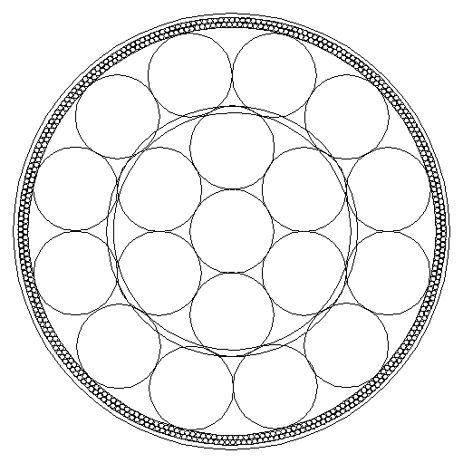
If the RB convection rolls sections are inserted into the equatorial plane, this is the first result, as shown above. The equatorial plane has a double function, as it is both a plane of convection and rotation. When the convectional plane and rotational plane are one and the same, this simple picture emerges shown above. It fits perfectly, can be logically explained, and should therefore be studied further.

Then what happens when the rotational plane and convectional plane are separated? For us, what happens is that we have to deal with those two factors separately. The proportions, when considered from the side of physics of convection and rotation together, remain the same for different latitudes. This is shown here below:

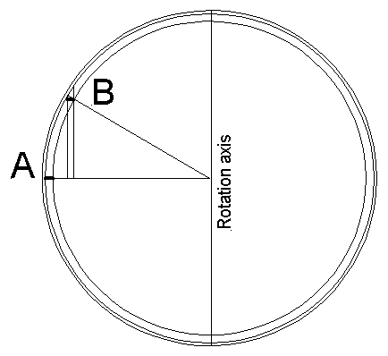
A convection roll section is examined at latitude A and latitude B. Section A is at equator with equal height and width. B is at a higher latitude, which is shorter and the deapth is the same, so at first it seem disproportionate, but according to physics it still has the proportions of a section of equal height and width. The rotational part is not combined with the convectional part, but when comparing them and putting them together, it is obvious that the rules of RB convection apply at B in the same way as at A. We are not used to think about two separate things at one time, so we better take the trouble to take those two factors of convection and rotation and combine them graphically to be able to understand this. Thereby, we can see that RB convection is taking place at all latitudes, not only within the plane of equator.

The remaining analysis concentrates on the horizontal layout of the convection rolls. The horizontal part can be calculated, and therefore the location of the rolls of different layers is known and can be used to explain geological features all over the world.

Uncategorized

Earthquakes in South Iceland

The South Iceland Seismic Zone (SISZ) spans over 1.5° from the Reykjafell mountain at the side of Hveragerdi town in the west to the volcano Hekla in the east, along the 64th parallel. A sign at the side of the ring road (No 1) where a turn can be made to the Skeid area (road No 30). A sign is put up there with information about the SISZ and the earthquakes occurring there. The earthquake zone has been measured quite accurately and surprisingly many papers written about it https://www.researchgate.net/publication/290227094_Seismicity_Pattern_in_the_South_Iceland_Seismic_Zone.

If a seismic zone has two ends, some kind of framework must be causing it. The Southern Lowlands are trapped in between the North American Tectonic Plate and the Eurasian Tectonic Plate. A convection roll of the asthenosphere and upper mantle is found to span 1.5° from east to west, and the seismic zone fits into that pattern. Noticing this, was only the beginning of long-term studying, and now the shaping of the framework is quite clear. Convection rolls of different layers cross each other exactly at this location, forming division lines underneath. These divisions are actual in two ways, being affected by the rotation of the convection rolls below, and the horizontal pulling and pushing of the two large-scale tectonic plates.

The sign is important, and I wish more people could visit the site.

On the sign, it can be seen how the SISZ has a counterpart on the Reykjanes Peninsula. A lot can be learned from the SISZ, because its proportions can be exactly measured, and the results can then be used to understand the geology of other areas in Iceland and elsewhere.

Uncategorized

Waiting for an Eruption

For those interested in geology, waiting for a predicted eruption must be exciting. It might even divide the geological community into two different teams, one being pro-eruptive, and the other not so sure about eruption to occur for a while. Having seen seven eruptions since december 18th 2023, the process seems to be quite well known. The land has risen to a certain level and then eruption has begun. This time the same thing is happening again, land has risen to a maximal level, and eruption is logically around the corner.

The graph from the Icelandic Meteorological Office shows how land has risen repeatedly to a similar level until an eruption was triggered. But we have other theories: 1) Some geologists are not so sure that the same story will be repeated this time. The present line showing how the surface is rising could be extrapolated to meet with an asymptote, not leading to an eruption at all, as drawn above. 2) Some say that because the accumulated magma in the reservoir responsible to the measured rising of the surface is heavier than the surrounding rock, and the bottom of the reservoir should therefore be subject to isostatic changes. The bottom of the reservoir should then be sinking, and the inflow of magma would therefore not be measured correctly, if only calculated according to the uplifting of the surface. 3) Some say that the sequence of eruption at Sunhnúkar Crater Row is over, and the next eruption will probably occur farther to the west at the so-called Eldvörp https://www.visir.is/g/20242528665d/spair-naesta-gosi-1.-mars. 4) Some say that the rifting process due to tectonic drift is temporarily over. Therefore there is not enough tension for further division, and without such an event pressure is not diminished and the volatiles will not be released within the magma in the reservoir and dyke. Therefore the eruption seems to be already overdue. Who is right?

Uncategorized

The Mid-Ocean Ridge of Iceland – How Does it Work?

The division between the North American Tectonic Plate and Eurasian Tectonic Plate through Iceland can be seen on this map. The mid-ocean ridges have a rift valley on the top, clearly marking the division line. Iceland has volcanic zones instead, found farther east.

The main volcanic zones show some resemblance with the mid-ocean ridges. The eastern edge is parallel with the Reykjanes ridge, 1.5 degrees farther to the east for the West Volcanic Zone, and 4.5 degrees farther east for the East Volcanic Zone. The Öræfajökull Volcano is found 6 degrees farther east. On the map, the two ridges have been connected with a red line.

Iceland is located on an abyss, roughly elliptical, clearly seen on maps showing the depth of the ocean. Marking that elliptical form and comparing with the connection between the relevant mid-ocean ridges, the connection point between the ridges and the central point of the ellipse are found to be one and the same point.

Looking into the details of all the volcanic zones of Iceland, it becomes clear that they can be divided into relatively small polygonal areas, mainly diamond-shaped. These polygons are marked here, and it turns out that practically all the volcanic zones can be divided into two polygonal areas.

All of this is derived from one and the same analysis of convection rolls within the mantle, presuming that it behaves in the same way as it does when heated under pressure in laboratory environment. It has been found that convection rolls form under those circumstances, of equal hight and width. Making a model, inserting convection rolls into the mantle of the Earth, leads to these conclusions.

All the geological procedures, and the consequences described here, thereby become readily understandable. Here are hundreds of other posts showing various aspects of how the mantle affects the surface of the Earth. Each of them has some additional indications.

Uncategorized

The Transitional Volcanic Activity of North Iceland

North and South Iceland seem to be quite different, as there are many volcanic zones active in the south, but only one in the north. The North Volcanic Zone (NVZ) in the north-eastern part of the country replaced the volcanic zone in Húnaflói, extending from Snæfellsnes Peninsula. But volcanic activity has been found in between these two zones in the past, mainly 1-2 million years ago. The Skagafjörður Volcanic Belt was a rift zone, widening the fjord by about 10 kilometers until activity came to an end. Also, activity did occur north of Eyjafjörður, and created for instance Grímsey, where the rocks are known to be around 1 million years old. https://www.visindavefur.is/svar.php?id=4435

This map shows how the transition has taken place in steps of 1.5° from west to east. The map base is from Wikipedia, the lines represent the pattern of division lines resulting from convection within the mantle.