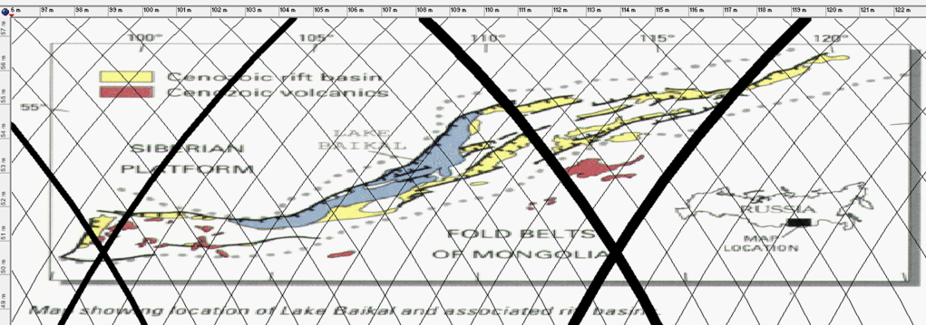
Examining Lake Baikal suggests that it can be interpreted as a surface expression of a deep-seated geodynamic process, potentially associated with a lower mantle convection roll extending 15° from east to west.
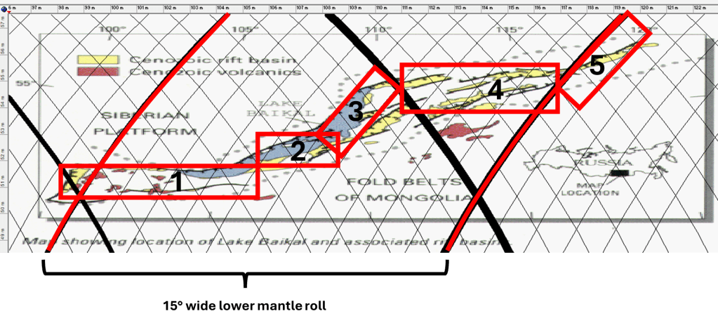
The Baikal Rift Zone can then be subdivided into five distinct structural sections, as shown below:
Western Segment – A deep, east–west–oriented basin forming the western extremity of both the lake and the rift system.
Central Basin – The deepest portion of the lake, representing the core of rifting activity and maximum crustal thinning.
Northeastern Segment – A structurally complex area aligned with the boundary between adjacent tectonic or mantle-flow domains (interpreted here as polygonal convection cells).
En Echelon Rift Systems – A series of east–west–trending, staggered rift structures situated between boundaries of different lower mantle flow layers, suggesting segmented deformation linked to deeper dynamics.
Eastern Termination – The distal end of the rift complex, where deformation becomes more distributed and transitions into surrounding tectonic regimes.
The principal rift axis appears to be located at the intersection of the central basin (2) and the northeastern segment (3), where structural and dynamic influences converge.
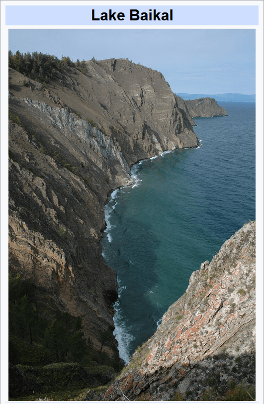
Lake Baikal is the deepest lake on Earth, reaching a depth of about 1,642 meters, and contains approximately 20% of the world’s unfrozen freshwater, making it one of the most significant hydrological reservoirs on the planet.
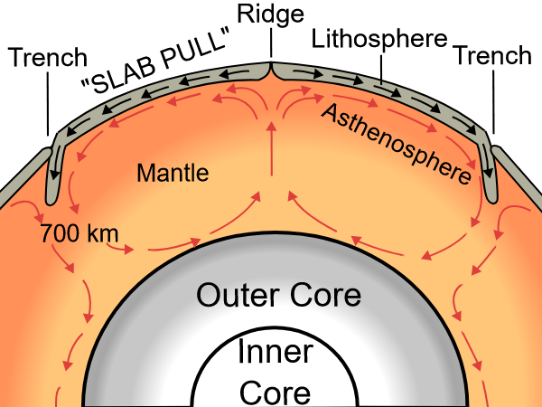
In this interpretation, the convection roll rotates counter to the direction of tectonic plate drift, helping to sustain and localize an extensive continental rift system. To show how the tectonic drift is opposed by the convection roll of lower mantle, this drawing below is added. It is not to scale, and the upper mantle convection rolls are omitted for clarity. But this is how it works.
The Baikal Rift Zone is often explained in conventional geology as a result of:
Far-field stresses from the collision of the Indian Plate with Eurasia
Lithospheric extension within the Eurasian Plate
Here, a deeper mechanism is added:
A large-scale lower mantle convection roll imposes stress on the tectonic plate.
Rotating opposite to plate motion, it thereby enhances extensional stress, stabilizing and sustaining the rift over long geological timescales.
The en echelon faulting often reflects oblique extension, which can result from interacting flow directions between mantle layers.
All of this begins with a drawing found all over, a simple section of mantle rolls. Basically, those are two circles turning in opposite direction against each other:
This is simple, accepted as a guess, though. Analysing this is a bit more complicated than one might think at first. Here is an example of how to handle that:
I — FOUNDATIONS
Chapter 1 — The Making of a Model
1.1 Plate tectonics as a descriptive model
1.2 Mantle plumes vs global structure
1.3 Missing geometry in geoscience
1.4 The need for a unifying framework
1.5 Observational inconsistencies
Chapter 2 — First Observations of Order
2.1 Iceland as a key to global structure
2.2 Regular spacing of volcanic zones
2.3 The 30° and 90° patterns
2.4 Symmetry across hemispheres
2.5 The Ring of Fire as a system
Chapter 3 — From Observation to Hypothesis
3.1 Recognizing repeating units
3.2 The idea of convection rolls
3.3 Linking surface features to deep structure
3.4 Early geometric interpretations
3.5 Formulating a testable model
II — THE CONVECTION ROLLS MODEL
Chapter 4 — The Mathematical Framework
4.1 The global equation of mantle rolls
4.2 The 1.5° discretization
4.3 The role of latitude (32°)
4.4 Directional equations
4.5 Spherical corrections
Chapter 5 — Vertical Structure of the Earth
5.1 Earth’s layered structure
5.2 120 km, 410 km, 670 km discontinuities
5.3 Equal height–width condition
5.4 Rayleigh-Bénard convection in Earth
5.5 Stability of convection rolls
Chapter 6 — Global Distribution of Mid-Ocean Ridges
6.1 Ridge alignment and geometry
6.2 Atlantic vs Indian vs Pacific
6.3 90° relationships
6.4 Iceland as a ridge–roll interface
6.5 Implications for seafloor spreading
Chapter 7 — Subduction Zones and the Ring of Fire
7.1 Convergent boundaries as part of the same system
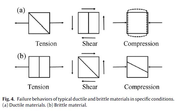
A tectonic plate is brittle at the top, but most of it is ductile. The fractures of ductile and brittle materials are different, and therefore magma can find different flowlines within different depth levels of the plate. This is explained in the article: https://www.sciencedirect.com/science/article/abs/pii/S009364131730561X as shown below:
Failure of brittle and ductile material theory (from Jiefei Gu, Puhui Chen – A failure criterion for isotropic materials based on Mohr’s failure plane theory).
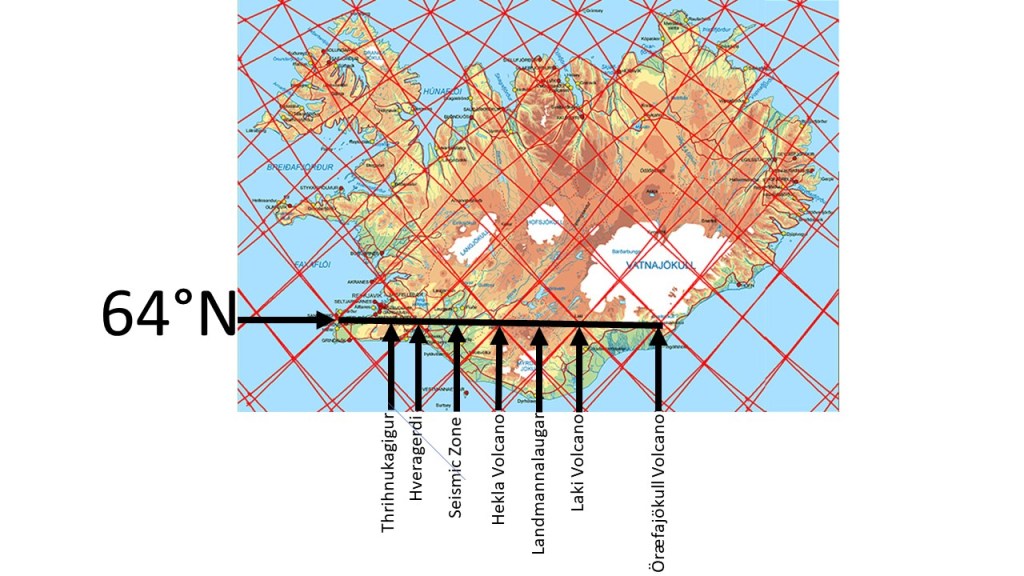
The polygons that characterize the southern half of Iceland are remarkably regular, allowing simple geometric patterns to emerge clearly. In both brittle and ductile layers, deformation occurs systematically: brittle layers are affected primarily by tension, while ductile layers accommodate shear. As a result, faulting tends to propagate from one corner of each polygon to the opposite corner. Within the volcanic zones, tension fractures are particularly evident, as illustrated in Figure (b).
Figure a: Features of the four polygons in South Iceland along 64th parallel.
The southern region of Iceland exhibits a high degree of polygonal regularity, enabling clear geometric relationships to be identified. Both brittle and ductile layers are systematically deformed: brittle deformation is dominated by tension, while ductile deformation accommodates shear. In both cases, faulting and strain localization occur preferentially along diagonals connecting opposing polygon corners.
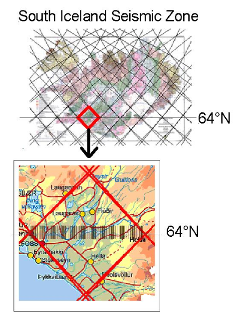
This structural organization is particularly evident along the 64th parallel, where the polygons approach a near-ideal diamond geometry. Within these polygons, east–west-oriented lineaments subdivide the structure along corner-to-corner axes. These features are independently supported by geophysical observations within the South Iceland Seismic Zone, where detailed measurements confirm the presence of such structural divisions.
Furthermore, the regional stress field associated with this polygonal framework predicts the development of volcanic fissures oriented NE–SW. This prediction is consistent with observed fissure swarms in Icelandic volcanic zones, indicating that their orientation is controlled by the underlying geometric and mechanical structure.
A notable deviation occurs on the Reykjanes Peninsula, where the central polygonal axis bends southward in its western segment. This deflection corresponds to its interaction with the Reykjanes Ridge and the adjacent polygonal system to the southwest, reflecting boundary-induced modification of the otherwise regular structure.
In contrast, other regions of Iceland display a more uniform configuration, with well-defined east–west axes extending directly between polygon corners, consistent with the predictions of the model.
Figure b: The SISZ with the earthquake faults marked as parllel N-S oriented lines.
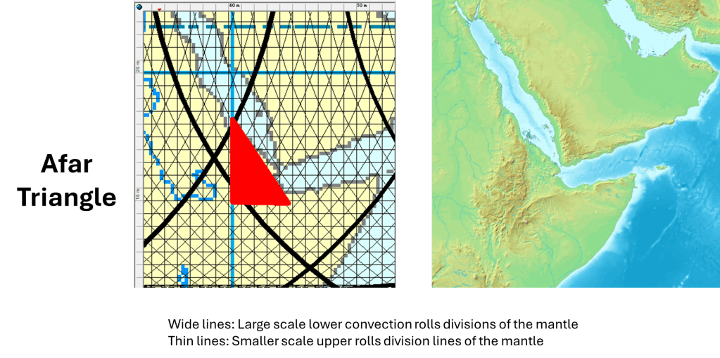
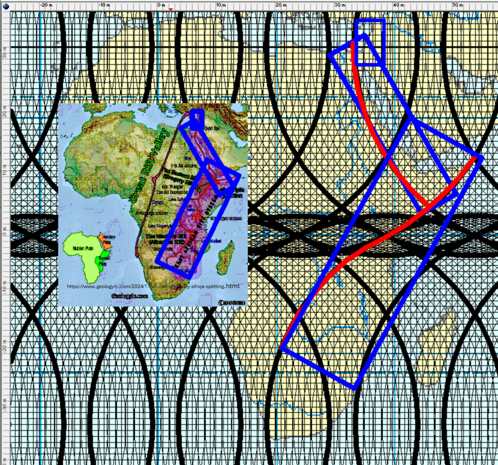
The Afar Triangle connects with the key equatorial division point, as the rift valley extends to there:
The Afar Triangle occupies a key geometric position within the mantle flow system. It is located at what can be interpreted as a corner of a larger convection framework, where different structural directions converge.
Its triangular shape is not incidental. The geometry is well defined:
the southern boundary trends roughly east–west
the western boundary trends north–south
the eastern boundary trends northwest–southeast
This configuration is consistent with earlier observations that similar directional patterns frequently appear in regions influenced by mantle convection rolls. In particular, these orientations correspond to the dominant structural directions expected where mantle flow organizes into a grid- or diamond-like pattern that is reflected at the surface.
The Afar Triangle therefore represents more than a tectonic junction. It marks a point where:
different directions of mantle flow interact
deformation becomes concentrated
and surface structures take on a geometrically organized form
This makes it a critical location within the broader East African Rift system.
A Key Junction in the African Rift System
The importance of the Afar region becomes especially clear when viewed in relation to the East African Rift.
The rift system in eastern Africa trends predominantly NE–SW, forming a broad zone of distributed extension across the continent. As this system propagates northward, it meets the Red Sea rift at Afar.
This intersection is not random.
Instead, it reflects the meeting of:
a continental-scale extension zone (East African Rift)
and an oceanic spreading system (Red Sea and Gulf of Aden)
At this junction:
the geometry of the rift system changes
deformation becomes more focused
and the transition from continental rifting to oceanic spreading is clearly expressed
Connection to Mantle Roll Geometry
From the perspective of mantle dynamics, the Afar Triangle can be interpreted as a surface expression of deeper mantle currents.
If mantle convection is organized into rolls and their intersections form angular or diamond-shaped patterns, then:
the edges of the Afar Triangle align with these structural directions
the triple junction reflects a node within this system
This provides a coherent explanation for:
the triangular geometry
the alignment of rift branches
and the concentration of tectonic activity in the region
Why Afar Matters
The Afar Triangle is therefore a key point in the Great Rift of Africa:
It is where a NE–SW-trending continental rift system meets a north–south-oriented oceanic spreading system, within a geometric framework that reflects deeper mantle flow structures.
This makes it one of the clearest locations on Earth where:
surface tectonics
geometric patterns
and mantle dynamics
can be studied together as parts of a single system.
The African Rift System has undergone continuous change over millions of years. In reality, it is a complex system that extends across most of eastern Africa south of the Sahara.
The system connects to the Afar Triangle, where a major tectonic junction occurs, and continues northward along the entire length of the Red Sea. There, a mid-ocean ridge follows a NNW-SSE orientation from the continental rift system in Africa. This shift can be explained by referring to different division lines within the mantle.
When this structure is compared with mantle flow patterns, a striking relationship emerges: the width of the continental rift valleys corresponds closely to the width of a single convection roll in the lower mantle. In contrast, the Red Sea spreading ridge appears to align primarily with a boundary between convection cells. The northern continuation of this boundary lies at the eastern most part of the Mediterranean Sea, trending roughly north–south.
The rift system is broadly symmetrical about the equator, although the NNE–SSW-trending block extends farther south than north. The Red Sea itself reflects a division line and related rifting process from Afar north to boundaries near 32°N, where the structural trend shifts into a more direct north–south orientation.
At the equator, the inferred boundaries in the lower mantle pass directly through the central rift zone. This is the only location on Earth where such deep mantle boundaries appear to coincide with continental surface structures. From this point, the angular distance is approximately 60° to the western coast of Indonesia and about 30° to the eastern coast of Africa.
When mapped, these regions display an unusual rectangular geometry, a pattern that has also emerged from surface geological observations. When compared with the mantle convection system, there is a notable correspondence between deep mantle boundaries and the corners of the rectangular rift domain in East Africa.
This relationship helps explain both the large-scale splitting of the African continent and the formation of the rift valleys themselves. The rifts can be understood as the result of interaction between mantle convection rolls and plate tectonic forces. Only through this combined framework can we explain why extension occurs across such an exceptionally wide region.
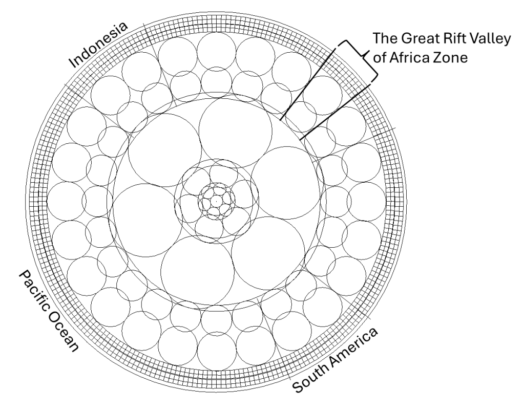
The symmetry around the equator is particularly striking. It is not only observable in mapped data but also consistent with mathematical formulations. When mantle convection rolls are modeled as uniform in both height and width within Earth’s layered structure, the positions of the continents align closely with the boundaries of these rolls. At the equator, or as for the Afar region 11°N, a section based on that method looks like this:
The broad nature of the East African Rift helps explain why Africa differs from regions such as South America and Indonesia. In those regions, continental margins tend to align with intersections of lower mantle convection rolls, whereas in Africa, the rifting occurs within the interior of the plate and does not coincide with such boundaries.
The bifurcation of Africa, and the way the rift system aligns with calculated mantle flow divisions, provides further evidence that can be used to reconstruct the internal structural framework of the Earth. This section of the equatorial plane of the Earth is made according to information about the Earth’s layers. The convection rolls 2D sections fit into those layers, and simultanously explain the existence of relevant transition layers. This also fits with the distribution of land mass along equator.
The pattern along equator is so amazingly clear, that it is strange no one mentions it, at no one therefore tries to explain it. The lack of discussion is a topic to be dealt with according to social science though, or other disciplines.
The East African Rift as a Distributed Zone of Extension
Mantle Flow, Plate Motion, and the Geometry of a Splitting Continent
The East African Rift is often presented as a simple example of a continent breaking apart. While this description is not incorrect, it does not capture the true scale and nature of the system. This is not a single line or a narrow plate boundary, but a vast zone of extension covering a large portion of eastern Africa south of the Sahara.
At certain latitudes, this zone spans up to half the width of the continent and measures approximately 15° in latitude, corresponding to roughly 1000–1500 km. This is highly unusual compared to most rift systems on Earth, which tend to be much narrower and more localized.
The question is therefore not only why Africa is rifting, but:
why the extension is distributed across such a broad region.
Not a Single Rift, but a System
4
The term “rift valley” can be misleading. It suggests a single structure, but in reality the East African Rift consists of:
multiple parallel rift branches
fault systems and fractures
broad zones of crustal thinning
large basins occupied by lakes
This is therefore not a single fracture, but a case of:
distributed extension
Deformation is spread across a wide region rather than localized along a single boundary. This immediately suggests that the causes are not confined to shallow levels, but are linked to deeper processes.
Lithosphere: Brittle Above, Ductile Below
To understand how such distributed extension occurs, we must consider the mechanical behavior of the lithosphere.
Above the Moho, the material is brittle and responds to stress by:
fracturing
forming faults
generating earthquakes
Below the Moho, the uppermost mantle behaves ductilely:
it deforms gradually
it flows over long timescales
it does not fracture in the same way
Under horizontal plate motion:
the ductile portion yields and accommodates deformation, while the brittle portion fractures.
This is why the system does not form a single rift, but many.
Below the lithosphere lies the asthenosphere, a lower-viscosity layer where flow is more easily sustained. However, the coupling between this layer and the overlying plate is not constant.
In some cases, a no-slip condition applies:
mantle flow is directly transmitted to the plate
motion in the mantle influences plate movement
In other cases, slip occurs:
the plate moves independently
mantle flow has limited direct influence
This variability is crucial:
mantle flow does not always directly control plate motion.
Mantle Rolls and the Scale of the System
To explain the width of the rift system, the mantle must be considered as a layered system of flow.
In the upper mantle, from roughly 120 km to 670 km depth, one can identify a system of smaller convection rolls. In this framework, these may be considered as approximately ten rolls, dividing the region into smaller dynamic units and influencing localized deformation.
Below this level, in the lower mantle, the structure appears different. The convection rolls are larger and extend over broader areas. Their surface expression corresponds to a width of 15°.
This is a key observation:
The width of the East African Rift corresponds to the width of these larger lower mantle rolls.
If so, the rift is not a local feature, but:
a surface expression of deeper, large-scale mantle structure.
Resistance to Plate Motion and the Origin of Extension
To understand why such a broad rift develops, it is necessary to consider the balance of forces.
If plate motion were unopposed, the lithosphere would move as a coherent unit. There would be no reason for it to break apart over such a large region.
The key factor is that:
some mantle rolls rotate against the direction of plate motion.
This creates resistance. We therefore have two interacting components:
the overall plate motion driving the system
opposing mantle flow providing resistance
The net plate motion is stronger and continues to drive movement. However, where resistance occurs:
tensile stress builds within the lithosphere
stress is distributed across a wide region
the system begins to deform
The result is:
ductile deformation at depth
brittle fracturing above
and the onset of rifting
Difference from Mid-Ocean Ridges
This mechanism differs fundamentally from what occurs at mid-ocean ridges.
At ridges:
convection rolls exist on either side
they move away from the ridge axis
and directly drive symmetrical extension
Thus:
extension is a direct result of divergent mantle flow.
In East Africa, however:
there is no single central axis
extension results from interaction between plate motion and opposing mantle flow
This produces:
a wide deformation zone
distributed extension
multiple rift branches
Why Africa Differs from Other Regions
This framework also explains why Africa differs from regions such as South America and Indonesia.
In those regions:
plate boundaries often lie along continental margins
they coincide with boundaries between mantle flow systems
coastlines reflect deep structural divisions
In Africa:
rifting occurs within the interior of the plate
it does not coincide with a coastline
and it is distributed across a broad region
This indicates that the relationship between surface tectonics and mantle structure varies between regions.
A Distributed Response of the Lithosphere
The East African Rift can therefore be understood as a distributed response of the lithosphere to underlying mantle flow.
The lithosphere stretches across a wide region:
the ductile portion deforms and distributes stress
the brittle portion fractures into multiple rifts
The result is a coherent but distributed system that reflects both material behavior and deeper forces.
Evolution Toward an Ocean Basin
If this process continues, the system may evolve over time.
Distributed extension may gradually localize:
forming a more defined plate boundary
eventually developing into a mid-ocean ridge
The East African Rift may therefore represent:
an early stage in the formation of a new ocean basin.
Conclusion
The East African Rift is not a simple valley, but a large and structured zone of extension. Its width — approximately 15° — suggests a connection to large-scale mantle flow systems.
By analyzing the system in relation to:
smaller convection rolls between 120–670 km depth
larger rolls below, spanning ~15°
and the resistance generated where mantle flow opposes plate motion
surface tectonics
lithospheric behavior
and the internal structure of the Earth
In this way, the rift system is not merely a local feature, but part of a larger and organized dynamic system within the Earth.