Uncategorized

Goðafoss – aligned like other waterfalls

There is one famous waterfall still not mentioned here. It forms a semi-circle, but the sections have certain alignments. This is the main one:

20180617_100020

Looking from above with the help of Google map, the alignment can compared with calculated direction of convection rolls underneath:

Goðafoss

The river Skjálfandafljót makes a turn before it reaches the fault responsible for the waterfall. The alignment is the opposite of Dettifoss (but the same deviation from north), and the same as for Selfoss in Jökulsá á Fjöllum.

Again, a composition of differently oriented faults combine at the site of the waterfall.


Faxi

Dynjandi


Uncategorized

Kleifarvatn – a lake between tectonic plates

Kleifarvatn is dividing N-America and Eurasia. The Krýsuvík volcanic system includes the lake with geothermal areas found both on its bottom and around it.

Kleifarvatn

A view to the NE over Kleifarvatn

You can say that the mountain on the left hand side belongs to America and Europe is on the right hand side. The lake has no rivers, but after earthquakes occurring in the year 2000 the water level lowered whereas fissures in the area opened up, making way for water flow towards the ocean.

Kleifarvatn - a lake between continents

The alignment of the Sveifluháls tuff ridge can be calculated directly as it follows the polar convection cells. At 64°N the equatorial and polar convection cells are aligned the same way.


Uncategorized

The Bridge Between Continents on Reykjanes Peninsula

The Bridge Between Continents on Reykjanes Peninsula is a popular tourist attraction. It is located at the western edge of the rift valley formed along the volcanic system of Reykjanes. Bridge Between Continents

The rift follows the direction of the polar convection cells, as shown here on Google map:

Bridge Between Continents - Reykjanes

The outstanding part of the rift, with the bridge over it, is close to another less prominent feature. It is found to be due to horizontal tectonic force, as the angle is half of the other compared with EW-axis. The rift is supposed to have been deepened by the combined effect of these two tectonic alignments.

This is very similar to the settings of the Almannagjá rift of Thingvellir National Park, where the combination of tectonic alignments forms high walls at the side of the rift valley.


Uncategorized

How to find geothermal heat in Holland?

Can we find geothermal heat with the help of convection cell system? Yes, it is the very base of exploring the Earth’s surface. But how? Let us see the relevant part of the world convection cell grid drawn on a Google map:

Holland - convection lines

The country is mainly made up by two polygons, with EW-axis from points 1-2 and 3-4. The topographic consistency is mainly found on the line between points 1 and 4. Divergent force should be found close to the coast between 1 and 3.

Accordingly, searching for geothermal resources should in the beginning mainly be focused on line 1-4. (Actually Geothermal energy in the Netherlands has been partly modeled, showing precisely this trend, and can be seen on maps showing the tectonics of the Netherlands.) Then the pressure exerted on these two polygons should be estimated according to the precondition that it is originated from the relevant sides. Then the reason for the division found along 1-4 will be made clear. Thereby it can be found out weather EW-axis or NW-axis is the main factor for weakness within the tectonic plate. Then the main faults within the crusts can be found and mapped. The heat flow from the Earth can then be utilized effectively, as water can be heated by flowing along the deep faults.

This is not easy, but at least in this way we should know a bit more about what we are doing.

Red lines show upwelling, the upper more (120-250 km depth) aligned SW-NE, the lower more (250-410 km depth) aligned SE-NW. Black lines show downwelling.


Uncategorized

The Shape of the Icelandic Shelf

Having analyzed the axis from Central Iceland through Hekla and Eyjafjallajökull, it is notable that the shelf surrounding Iceland also follows the same trend.

Landgrunnid - sporaskja

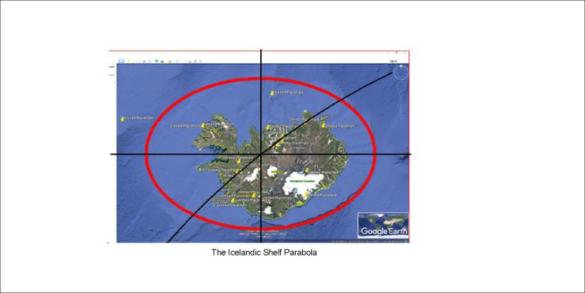
The edge of the shelf closely follows an elliptical form, centered at the crossings of the continuation of the Reykjanes Ridge and the Hekla NS-axis. The parabola itself is centered around the relevant EW-axis.

Is there a reason for this we can explain? Yes, similar to the explanation about Snæfellsjökull and Snæfell.

Snæfellin 02

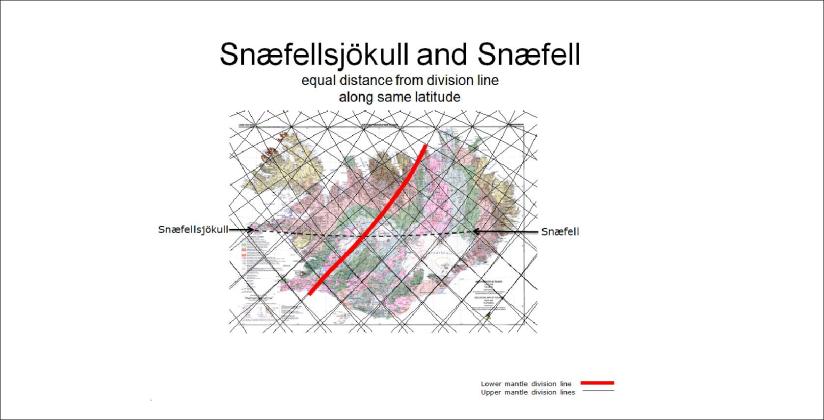
These mountains are equidistant from the same NS-axis as the shelf ellipse. The central point for the two volcanoes is on the division line of the lower mantle and thereby of the downwelling line of upper most mantle. The shelf ellipse central point is the next crossing nort of the main line, namely the extended line from the Reykjanes ridge, which is upwelling closest to the tectonic plate (120 km).

The ellipse is as close to being perfect as possible, having in mind all the complexities that should shape the ocean shelf around Iceland. Also, the fact that the highly elliptical Eyjafjallajökull is shaped around the same NS-axis is a curiosity.

Eyjafjallajökull - EW alignment

So much to speculate! But the base has been explained with the convection cell model.