Uncategorized

Three Great Tectonic Rings Around the Earth: The Indian Ocean Ring, the Atlantic Ring, and the Pacific Ring of Fire

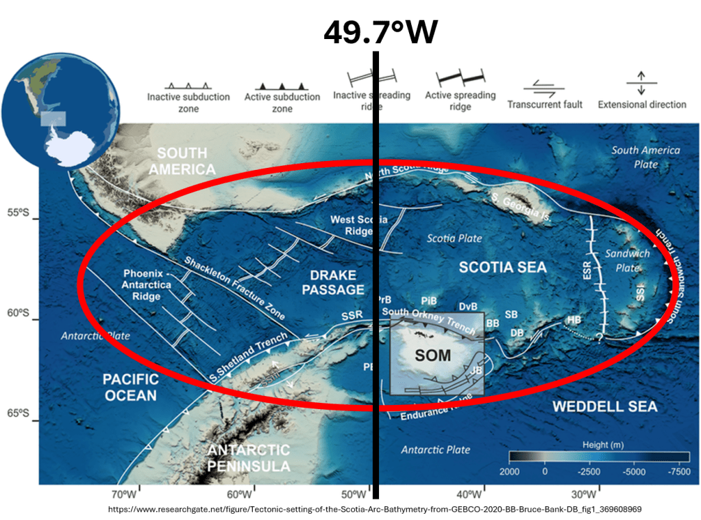
Starting from the possible sixfold division around Antarctica, it is possible to examine how this geometry relates to the tectonic plates and major tectonic systems outside the Antarctic region.

The Pacific Ring of Fire is particularly important in this respect because its geometry can be analysed in considerable detail. When examined in relation to the Mantle Convection Roll model, its overall form becomes even more clearly defined.

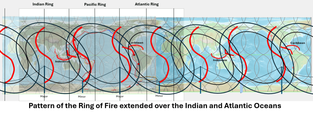
The Pacific Ring of Fire, Indian Ocean Ring and Atlantic Ring
shown in relation to the 60° sector division around Antarctica.
The three overlapping systems each span approximately 120° between their inner boundaries,
providing a possible geometric connection between the pole-centred Antarctic structure
and the major tectonic systems surrounding the globe.

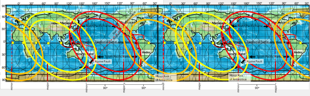
Several key locations show remarkably simple angular relationships when measured from the geographic South Pole. For example, the angle between the directions towards the Alpine Fault in New Zealand and Yellowstone is approximately 90°. This corresponds with another geometric relationship already identified: the Alpine Fault lies close to the continuation of the minor axis of the Antarctic ellipse, whereas Yellowstone lies close to the continuation of its major axis.

Thus, two major parts of the Ring of Fire can be related directly to the two perpendicular axes of the Antarctic geometry. The Ring of Fire also extends southward into the Antarctic tectonic system. This makes it possible to examine its geometry not only as a Pacific feature, but as part of a larger global arrangement.

From 90° and 45° to 60° and 120°

The two principal axes associated with the geometry of the Ring of Fire are themselves inclined by approximately 45° relative to one another in the larger construction used here. Once the possible 60° sector division around Antarctica is introduced, another question naturally follows:

How does the geometry of the Ring of Fire relate to 60° and 120° angular divisions? An interesting relationship appears at the equator, as the outer limits of the Pacific Ring of Fire, measured approximately from Indonesia to the western margin of South America, span about 150° of longitude.

However, the inner margins of the Ring of Fire lie approximately 15° inward from each outer margin.

Therefore we get; 150° − 15° − 15° = 120°, so the effective width of the inner Ring of Fire is consequently about 120°.

This is particularly significant because 120° is exactly one third of a complete circle: 360° / 3 = 120°.

It therefore becomes possible to construct three comparable great tectonic ring systems around the Earth, each displaced by approximately 120° from the next.

These may provisionally be called:

1. The Pacific Ring of Fire
2. The Indian Ocean Ring
3. The Atlantic Ring

The Pacific Ring is by far the most conspicuous of the three because the tectonic boundaries around the Pacific are exceptionally well developed: long subduction zones, major transform systems, volcanic arcs and associated seismic belts together produce the familiar Ring of Fire.

The other two proposed rings are less visually obvious. Their boundaries are interrupted by continents, ocean basins and tectonic systems of different ages, and they have not generally been considered as parts of equivalent circular structures. Nevertheless, when their positions are examined in the same geometric framework, substantial agreement with known geological features becomes apparent.

Three overlapping 120° systems

The important point is that these three rings should not necessarily be imagined as three completely separate circles placed side by side, and they overlap.

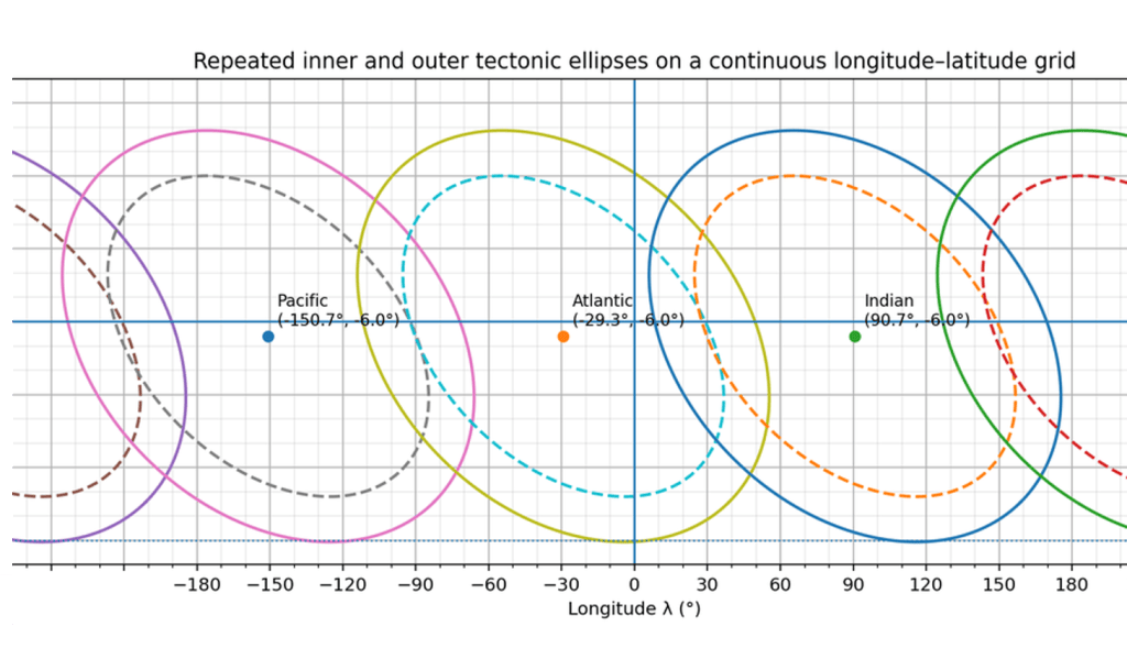
If three equivalent rings are arranged around the globe so that the inner margins of neighbouring rings meet or intersect at the principal division points, a repeating global pattern is produced. In this construction, each ring occupies approximately a 120° internal sector, while the outer tectonic expression may extend farther and overlap with the neighbouring ring.

This overlap may be geologically important. The Pacific Ring of Fire itself becomes easier to understand when viewed in this way.

Kermadec–Tonga and the overlap with the Indian Ocean Ring

One of the most interesting examples is the Kermadec–Tonga system. Kermadec–Tonga lies noticeably inside the broader geometrical outline of the Pacific Ring of Fire rather than simply following its outermost boundary. In a model based only on a single Pacific ring, this position appears somewhat anomalous.

However, if the Indian Ocean Ring overlaps the Pacific Ring, the position of Kermadec–Tonga becomes much more natural. It lies within the zone where the two systems interact.

Thus, what may initially appear to be an irregularity in the Pacific Ring may instead represent the superposition of two larger tectonic geometries:

Pacific Ring + Indian Ocean Ring.

This would also help explain why the southwest Pacific is tectonically much more complicated than a simple elliptical outline would suggest. The region around New Zealand, Kermadec, Tonga, Fiji and the neighbouring back-arc systems lies precisely where different large-scale tectonic systems would be expected to overlap.

In this interpretation, the complexity is therefore not necessarily evidence against the larger geometry. It may actually be one of its consequences.

Antarctica as the geometric reference

Antarctica provides an unusually useful reference system for examining these relationships because several different geometries appear to be centred on, or organized around, the South Polar region.

At least three levels can be distinguished:

A global rather than a regional geometry

The important point is not simply to draw three circles on a map and search for features that happen to lie upon them. The relevant question is whether independently mapped geological structures repeatedly coincide with the predicted boundaries, axes, intersections and overlap zones.

The Pacific Ring of Fire provides the clearest test because its tectonic structure is so well mapped. Its inner and outer margins can be distinguished, its major axes can be compared with Antarctic geometry, and key locations such as the Alpine Fault, Yellowstone and Kermadec–Tonga provide additional geometric constraints.

If the same construction can then be followed through the Indian Ocean and Atlantic regions, using independently mapped ridges, subduction zones, continental margins, transforms and other major tectonic boundaries, the comparison becomes considerably more significant.

The proposed relationship can therefore be summarized as:

Antarctic 60° sectors
→ pairs of sectors forming 120° divisions
→ three overlapping tectonic rings around the Earth.

The three proposed systems are:

Pacific Ring of Fire — Indian Ocean Ring — Atlantic Ring.

Of these, the Pacific Ring is presently the clearest geological expression. The Indian Ocean and Atlantic rings require more detailed examination, but their predicted positions already coincide with several major tectonic structures.

Perhaps most importantly, viewing the three rings together does not weaken the familiar geometry of the Pacific Ring of Fire. It may actually make it more complete, because features such as the inward position of the Kermadec–Tonga system can be interpreted as the result of overlap between neighbouring global tectonic systems rather than as departures from the general pattern.

The three tectonic large-scale circles and how they relate to the Convection Rolls Model, with convectionr rolls division lines of main mid-ocean ridges and convergent boundaries superimposed on the map.
Uncategorized

From Fan-Shaped Basins to Polar Symmetry in Antarctica

Antarctica displays several different levels of large-scale geometric organization. These should not be confused with one another, because they are based on different observations and have different degrees of certainty.

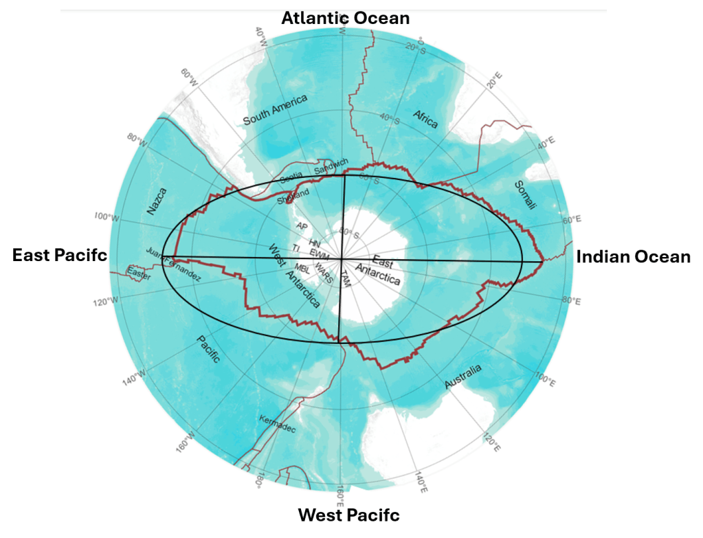
Antarctica Tectonic Plate map with a superimposed elliptical form.

Article link (with inserted map): https://www.nature.com/articles/s41561-026-01991-6

Map base: https://www.sciencedirect.com/science/article/pii/S1674984722000775

At the most familiar level, the continental part of Antarctica is divided into East Antarctica and West Antarctica. East Antarctica consists largely of old Precambrian continental crust, whereas West Antarctica is much more tectonically fragmented and includes the West Antarctic Rift System. The Transantarctic Mountains form the most conspicuous boundary between these two major regions. This fundamental division has been recognized for many decades and is firmly established by geological and geophysical observations.

At another scale, when the entire Antarctic tectonic plate is considered, including its oceanic lithosphere, a broader geometric pattern becomes visible. In the Mantle Convection Roll model, the outline of the Antarctic Plate can be approximated by an elliptical form centred approximately on the South Pole. A major and a minor axis then divide this ellipse into four main sectors. The axes used in this comparison are approximately 70°22.5′E–109°37.5′W and 160°22.5′E–19°37.5′W, respectively.

A third and much more tentative possibility has now become particularly interesting. New geophysical results from East Antarctica may indicate that another level of organization exists: a division into sectors of approximately 60° around the South Pole.

This is not established. It is a geometric possibility suggested by comparison between the new observations and the larger Antarctic pattern. But the measurements are remarkable enough to make such a comparison worthwhile.

The East Antarctic Fan-Shaped Basin Province

In 2026, Armadillo et al. described what they call the East Antarctic Fan-Shaped Basin Province (EAFBP). Using improved subglacial topographic data together with seismic, gravity and magnetic information, they identified 30 major basins beneath a very large part of the East Antarctic Ice Sheet. Many are approximately V-shaped and elongated radially towards the interior of Antarctica. Collectively, the basins form a huge fan-like structure extending roughly from Prydz Bay at 70°E to the Transantarctic Mountains at about 160°E.

This is not merely a visual impression from a map. The authors fitted 60 great circles to the longitudinal edges of the basins and calculated more than one thousand intersections. From these they obtained a best-fitting Euler pole at 86.4°S, 129.9°E.

This point is only about 3.6° of latitude, or roughly 400 km, from the geographic South Pole. The fan also has a well-defined axis close to the 130°E meridian, passing through the Belgica Subglacial Highlands. The authors call this the Belgica Bisector. The observed basin system is divided by this line into a sinistral sector to the west and a dextral sector to the east.

There is additional evidence that the geometry penetrates deeply into the lithosphere. Models based on seismic and gravity information show reduced crustal thickness beneath the major basins, while seismic tomography identifies low-velocity anomalies beneath the Wilkes and Aurora basins at upper-mantle depths. Thus, the fan-shaped pattern is not simply a feature produced by glacial erosion at the surface.

Perhaps even more strikingly, the authors identify two approximately circular transverse shear belts. Independent fitting gives Euler poles at 84.2°S, 130.8°E and 83.1°S, 129.5°E.

Thus three separately calculated geometric poles cluster within a relatively small region close to the South Pole and close to the same meridian: 86.4°S, 129.9°E, 84.2°S, 130.8°E, and 83.1°S, 129.5°E.

This repeated convergence towards the polar region is an important observational result, regardless of how its cause is ultimately interpreted.

Rotational extension — observation or explanation?

Armadillo et al. interpret the structure as the product of distributed intraplate rotational extension. In their model, the crust opened rather like a handheld fan around an Euler pole close to the South Pole. The Aurora and Wilkes basins developed on opposite sides of the Belgica Bisector, and displacement increased away from the pivot. The geometry certainly supports a rotational description.

However, there is an important distinction between describing the resulting deformation and identifying the deeper force that produced it. In the interpretation considered here, rotational extension may be a secondary kinematic effect rather than the primary geodynamic cause.

The proximity of the calculated Euler pole to the geographic South Pole is therefore particularly important. It does not, by itself, prove that Earth’s rotation caused the deformation. An Euler pole is fundamentally a geometric description of rotational motion, and many plate motions have Euler poles unrelated to geographic poles. Nevertheless, when a continental-scale system of radially arranged structures produces several independently calculated deformation poles close to the geographic pole, the relationship deserves attention—particularly in a model in which mantle convection itself is organized by planetary rotation.

The role of Earth’s rotation

Earth’s rotation alone cannot provide a satisfactory direct mechanical explanation for opening major crustal basins hundreds or thousands of kilometres long. The stresses required must ultimately be transmitted through the lithosphere from processes capable of doing substantial tectonic work.

In the Mantle Convection Roll model, the connection is indirect but mechanical:

Earth’s rotation → organization of mantle convection → systematic mantle-flow stresses → deformation of the lithosphere.

The rotation of the Earth organizes the convection system. The mantle flow then supplies the forces acting on the overlying lithosphere. From this perspective, a tectonic pattern centred close to the geographic pole would not result simply from a vague “rotational force”. It would reflect the geometry of a mantle-flow system whose organization is itself controlled by rotation.

The new Antarctic measurements provide evidence for the geometry of deformation. They do not establish the Mantle Convection Roll interpretation. But they provide a new and unusually clear geometric pattern against which that model can be tested.

Could Antarctica contain six alternating 60° sectors?

The mapped EAFBP extends approximately from 70°E → 160°E.

Its Belgica dividing line lies near 130°E. Consequently, the observed western part extends approximately 70°E → 130°E = 60°.

The mapped eastern part extends only 130°E → 160°E = 30°.

But 160°E corresponds approximately to the Transantarctic Mountains and the transition into West Antarctica. The quality and nature of the available observations change substantially beyond this region. The absence of a mapped continuation therefore does not necessarily demonstrate that deformation stopped there. Indeed, the West Antarctic Rift System itself records enormous crustal extension and a long history of tectonic reorganization.

This permits an alternative geometric question. What if 130°E represents the boundary of a 60° sector, rather than the centre of the complete Antarctic deformation system? A hypothetical dextral sector could then extend approximately 130°E → 170°W, with its centre at 160°E.

The next 60° sector would extend 170°W → 110°W, and could potentially display predominantly sinistral characteristics.

If this alternating pattern continued around the pole, the full 360° circumference would consist of six sectors:

sinistral – dextral – sinistral – dextral – sinistral – dextral, each occupying approximately 60°.

This is presently only a hypothesis. The available geophysical mapping is far too incomplete to claim that such a sixfold structure has been demonstrated. But there is an interesting numerical consequence. A system beginning with a sector boundary near 130°E generates boundaries approximately at:

10°E – 70°E – 130°E – 170°W – 110°W – 50°W.

Its sector centres would lie at:

40°E – 100°E – 160°E – 140°W – 80°W – 20°W.

This has an unexpected relationship with the independently derived elliptical geometry of the Antarctic Plate.

The proposed major elliptical axis, at approximately 70°22.5′E ↔ 109°37.5′W,

lies almost exactly on two opposite boundaries of such a 60° system.

The proposed minor elliptical axis, at approximately 160°22.5′E ↔ 19°37.5′W, instead lies almost exactly through the centres of two opposite sectors. Thus the possible sixfold division would not replace the fourfold elliptical division. The two geometries could be superimposed.

One describes the principal axes and quadrants of the Antarctic Plate, and the other might describe an alternating pattern of deformation around the pole.

Antarctica therefore shows three different levels of organization

The distinction can be summarized conceptually as follows:

1. Twofold division — continental geology

East Antarctica and West Antarctica represent the first-order geological division of the Antarctic continent.

2. Fourfold division — Antarctic Plate geometry

When the oceanic part of the tectonic plate is included, the larger outline can be examined as an approximately elliptical, pole-centred structure divided into four quadrants by its major and minor axes.

3. Possible sixfold division — internal deformation

The newly identified fan-shaped basin system raises the possibility that deformation around the pole may additionally be organized into approximately 60° sectors, possibly with alternating sinistral and dextral characteristics.

Only the first of these is conventional tectonic classification. The second is a geometric observation made in the Mantle Convection Roll analysis. The third is presently a hypothesis arising from comparison with the newly published EAFBP results.

It is important not to present the sixfold division as established geology.

What is established by the new measurements is already remarkable: a semi-continental-sized system of subglacial basins is arranged radially around a focal region very close to the South Pole; two major basins are approximately symmetrically arranged about a ~130°E bisector; the crust is thinned beneath major parts of the system; and three independently calculated deformation poles cluster close to the South Pole.

A pole-centred continent

This is the broader significance of the observations.

Antarctica contains geological structures whose large-scale geometry is demonstrably organized with respect to a region close to the geographic pole.

The authors of the EAFBP study explain this through rotational extension around an Euler pole. That is a legitimate kinematic interpretation of their observations.

The Mantle Convection Roll model asks a different question: Why should a continental-scale deformation system have a rotational centre so close to the geographic South Pole in the first place?

Within this model, the answer would not be that Earth’s rotation directly tears the crust apart. Rather, Earth’s rotation organizes the underlying mantle-convection system. Different components of that system generate different directions and strengths of mantle flow, and those flows provide the forces required for extension, shear, compression and eventual continental separation.

This also provides a possible context for the fragmentation of Gondwana around Antarctica. Different continental fragments separated from different parts of the Antarctic margin at different times. Australia, Zealandia, India, Africa and South America did not detach simultaneously, and their individual histories must be treated separately. Nevertheless, it remains possible that pre-existing, pole-centred mantle-flow geometry influenced where the lithosphere was stretched, where major weaknesses developed, and how those weaknesses were repeatedly reactivated.

Interestingly, Armadillo et al. themselves propose that the northern margin of the fan-shaped province created or exploited a lithospheric weakness that later influenced the separation of Australia from Antarctica and the geometry of the conjugate continental margins.

The difference lies mainly in the proposed primary cause.

Their model begins with rotational extension of the Antarctic lithosphere.

The Mantle Convection Roll interpretation would place another level beneath it:

planetary rotation → organized mantle convection → lithospheric stress field → rotational extension and other tectonic responses.

The fan-shaped opening would therefore be an expression of the system rather than its fundamental cause. For that reason, the new East Antarctic results are particularly useful. They do not need to have been discovered from the Mantle Convection Roll model, nor do they need to have been measured specifically to test it. Quite the opposite: their value lies in being independent geophysical observations.

The structures were mapped from subglacial topography, seismic data, gravity and magnetic measurements. Their geometry was calculated independently. Only afterwards can these observations be compared with the predicted or previously identified geometry of a pole-centred mantle-convection system.

That is precisely the kind of comparison on which the model can be tested.

Reference: Armadillo, E. et al. (2026), A fan-shaped subglacial basin province in East Antarctica formed by rotational extension, Nature Geoscience 19, 715–722, doi:10.1038/s41561-026-01991-6.

Uncategorized

Antarctica as a Pole-Centred Tectonic System: Fan-Shaped Basins, Elliptical Geometry, and the Role of Earth-Rotation-Controlled Mantle Flow

Recent work on the East Antarctic Fan-shaped Basin Province (EAFBP) has added an important new element to the large-scale tectonic interpretation of Antarctica. The newly described subglacial basin system in East Antarctica appears, in map view, as a broad fan-shaped arrangement of basins extending across a major sector of the Antarctic continent. When this pattern is placed into the wider geometric context of the Antarctic Plate, it becomes especially interesting. It falls within one of the principal quadrants of the Antarctic tectonic framework and appears to support the broader view that Antarctica has been structurally organized around the South Pole.

Map of the East Antarctic Fan-shaped Basin Province inserted into a map base of the Antarctic Tectonic Plate,
with the elliptical form imposed.

In the interpretation proposed here, the fan-shaped basin province should not primarily be understood as the result of “rotational extension” in the conventional tectonic sense. That description may be useful as a secondary geometric effect, because the basin pattern does indeed resemble a system opening around a polar pivot. However, the deeper cause is interpreted differently. The main driving mechanism is proposed to be the mantle convection roll system, whose geometry is itself controlled by the rotation of the Earth. In that framework, the tectonic structures observed at the surface are not independent phenomena, but rather the upper expression of a mechanically organized global flow system.

The significance of the EAFBP is therefore not only that it reveals a remarkable basin province beneath the East Antarctic Ice Sheet, but also that it provides an additional geometric marker that can be compared with the larger Antarctic pattern. The province occupies, broadly, the sector from about 70°E to 160°E, which corresponds closely to one of the major 90-degree quadrants previously identified in the Antarctic tectonic geometry. When an elliptical form is imposed on a base map of the Antarctic Plate, this fan-shaped province falls neatly into the relevant eastern quadrant. That agreement is striking, because it suggests that the basin province is not randomly located, but is related to the same organizing framework that also defines the larger Antarctic shape.

This supports the idea that Antarctica has been shaped in a fundamentally pole-centred way. The continent is not simply a passive remnant of Gondwana later modified by local tectonic events. Rather, its large-scale geometry appears to reflect long-term organization around the South Pole, with sectors, axes, and boundaries corresponding to the underlying structure of the mantle flow field. In this view, the approximately elliptical form associated with Antarctica is not merely descriptive. It expresses a real structural order connected to the way mantle flow has been organized beneath the plate over geological time.

A key point in this interpretation is that the Earth’s rotation influences the structure of the mantle convection system. The convection rolls are not assumed to form arbitrarily. Instead, they are organized into a systematic pattern shaped by planetary rotation, including stronger and more coherent flow components associated with the equatorial zone and weaker components toward the poles. This difference in flow intensity has major tectonic consequences. Around Antarctica, it implies that the main continental mass remained largely within the high-latitude, polar part of the system, whereas Australia came to occupy a more marginal position relative to the Antarctic-centered framework.

That distinction may help explain why Australia separated from Antarctica. In this interpretation, Australia lay outside the principal polar ring, whereas most of the remaining Antarctic continental mass remained within the zone bounded near 64°S. The mantle currents extending outward from the equatorial regions are interpreted as significantly stronger than those active near the poles. As a result, Australia was subjected to a stronger northward-directed pull by the mantle flow system, while the Antarctic remainder stayed more closely tied to the polar domain. The eventual separation of Australia is therefore interpreted not simply as a local rifting event, but as the consequence of a broader contrast between strong equatorward mantle flow and weaker polar circulation.

This also gives a broader meaning to the structural boundaries found near 64°N and 64°S. These latitudes are interpreted as significant because they mark transitions between different parts of the mantle convection roll system. In other words, the tectonic and geometric organization seen near those latitudes reflects a deeper change in the style or strength of mantle flow. In the Antarctic case, the continental mass within the polar zone remained organized around the pole, while the portion extending beyond that structural limit—most notably Australia—became increasingly subject to the stronger traction of lower-latitude flow.

From this perspective, the fan-shaped basin province described in East Antarctica may be viewed as a valuable new observational constraint. Its geometry is real and important, but its significance lies less in the idea of self-contained rotational extension and more in the fact that it records how the Antarctic lithosphere responded to the larger mantle-flow architecture. The fan shape may therefore be seen as a surface expression of stress and deformation imposed by the convection system, rather than as the primary driving mechanism. “Rotational extension,” if used at all, should thus be treated as a descriptive term for the resulting geometry, not as the fundamental explanation.

The broader conclusion is that Antarctica appears to have evolved as a pole-centred tectonic system, shaped by mantle-flow organization around the South Pole and ultimately governed by the rotational dynamics of the Earth. The newly recognized EAFBP fits well into this framework. When inserted into a base map of the Antarctic Tectonic Plate with the elliptical form imposed, it strengthens the case that Antarctic tectonics is best understood not as a set of isolated regional events, but as part of a coherent global geometric system.

Suggested reference note: This interpretation can be discussed in relation to the 2026 Nature Geoscience paper on the East Antarctic Fan-shaped Basin Province, together with relevant studies on Antarctic tectonic structure, Dronning Maud Land, Prydz Bay, and the tectonic evolution of the Antarctic–Australian sector.

Uncategorized

Geometric Comparison of the San Andreas and Alpine Faults

The tectonic settings of the San Andreas Fault in California and the Alpine Fault in New Zealand are comparable in several respects. When the elliptical geometry of the Ring of Fire is constructed, the two faults appear approximately opposite one another on either side of the Pacific, with their positions related to the minor axis of the ellipse. A closer comparison, however, reveals several additional geometric relationships.

As shown on the maps below, the central parts of both faults coincide with major lower-mantle boundaries predicted by the Mantle Convection Roll system. In the case of the San Andreas Fault, the inner boundary of the Ring of Fire ellipse also closely coincides with the creeping section of the fault. The San Andreas Fault therefore provides one of the clearest examples of the proposed geometric position of the inner boundary of the Ring of Fire. The midpoint of the creeping section, at approximately 36.38°N, 120.98°W, lies on one of the principal boundaries of the lower-mantle roll system.

The northwestern continuation of the San Andreas system is also noteworthy, as it trends toward the southern end of the Juan de Fuca Ridge. From the central part of the San Andreas Fault, a line can then be drawn toward the Yellowstone Caldera. Yellowstone also lies on a north–south axis that, in the geometry developed here, represents a continuation from the major axis of the Antarctic ellipse. This N–S axis also corresponds to a central axis within the Mantle Convection Roll system.

A closely comparable arrangement is found at the Alpine Fault. The central part of the fault lies on a principal lower-mantle boundary, in much the same way as the central part of the San Andreas Fault. The orientation of the Alpine Fault is also approximately parallel to the line connecting the San Andreas Fault with Yellowstone. A second parallel line can therefore be drawn from the central Alpine Fault toward an N–S axis extending from the minor axis of the Antarctic ellipse. This produces a geometric counterpart to the San Andreas–Yellowstone relationship.

The intersection between this N–S continuation of the Antarctic minor axis and the minor axis of the Ring of Fire ellipse defines, in this construction, the outer boundary of the Ring of Fire ellipse. The distance from the Alpine Fault to this intersection is shorter than the corresponding San Andreas–Yellowstone distance. This difference is related to the fact that the four N–S axes used in this geometry are systematically displaced approximately 1.5° eastward from the corresponding system centres of the Mantle Convection Roll model.

The distance between the San Andreas Fault and Yellowstone corresponds to one complete lower-mantle convection-roll interval, equivalent to ten smaller roll intervals. In the Alpine Fault case, the corresponding distance amounts to eight such intervals. According to this geometry, the inner and outer boundaries of the Ring of Fire are therefore not perfectly symmetrical.

Approximated basic shape of the Ring of Fire.

Zooming in: The comparison consequently reveals a considerable number of mutually consistent geometric relationships between the San Andreas and Alpine faults: their opposing positions relative to the minor axis of the Ring of Fire, the location of their central sections on major lower-mantle boundaries, the parallel orientation of the faults and their associated connecting lines, and the regular spacing produced by the Mantle Convection Roll system. The following maps are presented to illustrate these relationships and allow the two regions to be compared directly.

San Andreas Fault and Yellowstone.

Hvað

The Alpine Fault.

Uncategorized

Possible Formation of the Elliptical Icelandic Plateau by Symmetric Crustal Extension


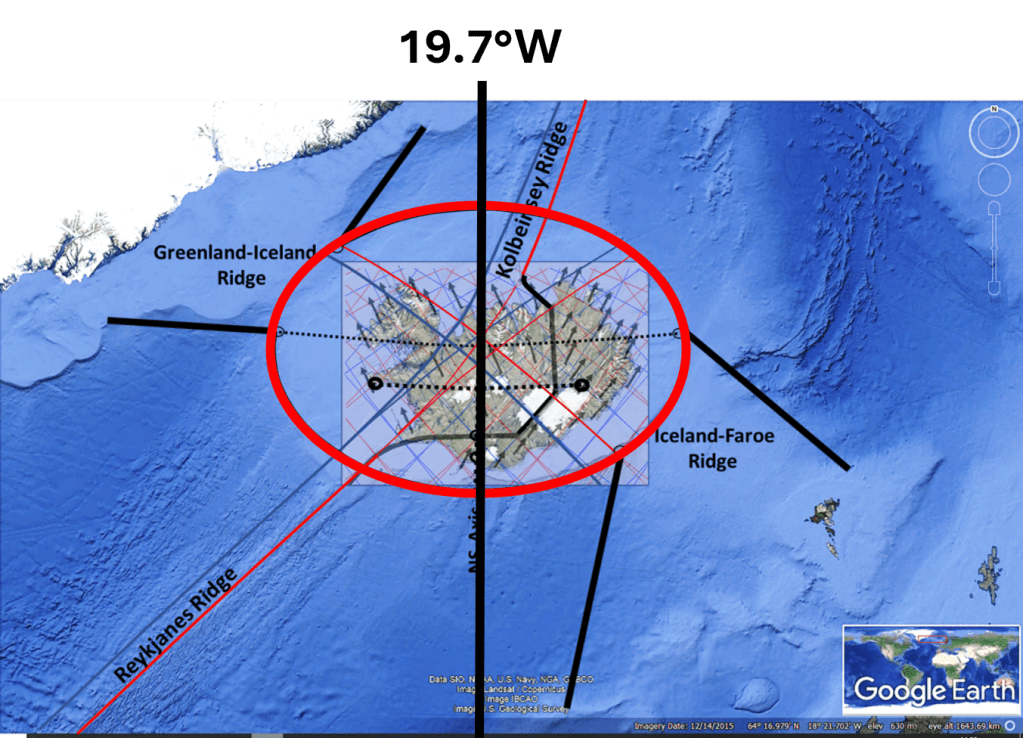
A striking feature of the Icelandic plateau is its broadly elliptical outline. The ellipse discussed here has its centre at approximately 65.600°N, 19.625°W. Its major axis is oriented exactly east–west along latitude 65.600°N, extending from approximately 27.300°W in the west to 11.950°W in the east. Its minor axis extends from approximately 63.000°N in the south to 68.200°N in the north.

The elliptical form of the Icelandic Plateau.

Map base: https://www.researchgate.net/publication/316330629_The_Greenland-Iceland-Faroe_Ridge_Complex

Using longitude λ and latitude ϕ, the ellipse is defined approximately by:

where λ denotes longitude, with western longitudes expressed as negative values, and ϕ denotes latitude.

The shape is particularly clear in the southeastern part of the Icelandic shelf, where relatively little later tectonic disturbance appears to have modified it. The most significant deviations occur in the northern sector, particularly around the Kolbeinsey Ridge, where younger spreading processes have substantially reorganized the crust. On geological and bathymetric maps, however, the elliptical geometry remains conspicuous. Of particular interest is that geological boundaries between the Icelandic part of the Greenland–Iceland–Faroe Ridge Complex and the adjoining ridge segments appear in places to follow the elliptical outline itself.

A stretched continental-crust interpretation

The geometry becomes especially interesting if the hypothesis proposed by Foulger and others is adopted as a working assumption: namely, that substantial amounts of stretched continental crust may remain beneath Iceland and parts of the Greenland–Iceland–Faroe Ridge Complex.

In such a model, Iceland would not consist exclusively of anomalously thick oceanic crust generated by excessive mantle melting. Instead, an older continental crustal component may have been progressively stretched, thinned, intruded by magma and covered by basalt during the opening of the North Atlantic.

If the remaining continental component beneath Iceland is approximately 20 km thick, whereas the original crust may have been 35–40 km thick, the crust must have undergone considerable areal extension. A simple volume-conservation calculation suggests that the original area could have been roughly one-half of the present affected area if the original crust was about 40 km thick.

The important point, however, is that the original block need not have been circular. It was probably elongated, because it represented part of the continental material being divided as Greenland separated from Europe. Its original structural connections would therefore naturally have extended toward Greenland on one side and toward the Faroe region on the other.

The Icelandic ellipse as a deformation envelope

The Icelandic ellipse should therefore not necessarily be interpreted as the original outline of a single continental fragment. A more plausible possibility is that it represents the finite deformation envelope of a wider zone of stretched continental crust.

The original continental material may have formed an irregular or elongated block, while long-term extension, lower-crustal flow, repeated rift relocation and magmatic intrusion produced a much smoother final deformation field. Over tens of millions of years, deformation distributed through a hot and mechanically weak crust can become considerably more regular than the original structural boundaries.

This possibility is compatible with several elements of Foulger’s model, particularly distributed extension, unstable and migrating spreading axes, broad transfer zones and ductile lower-crustal flow. Foulger does not propose the Icelandic ellipse itself, but the physical processes invoked in that model provide mechanisms through which a broad and relatively smooth deformation envelope could develop.

East–west extension

The major axis of the ellipse lies precisely east–west along 65.600°N. Within the mantle-convection-roll model, this is also an important structural latitude. The line passes through the central part of the northern volcanic-zone system when measured from north to south and through the geometric centre of the shelf ellipse.

The principal crustal extension can therefore be considered primarily east–west. This does not mean, however, that all deformation or material transport must have occurred east–west. The geometry suggests that the principal extension and the directions along which deformation was distributed may be different.

A useful distinction can therefore be made between the principal direction of extension, which was east–west, and the broader distribution of deformation, which appears to have taken place along northeast–southwest and northwest–southeast trends. This relationship may be fundamental to understanding the overall form.

Mirror-symmetric mantle boundaries

Within the mantle-convection-roll model, the major boundary associated with the Reykjanes Ridge continues through the central region beneath Iceland. It follows a curved SW–NE trajectory. A second underlying boundary forms a geometrical mirror image of this structure.

Both pass through the central region of the Icelandic ellipse. These two oblique systems can be considered mirror-symmetric components of a larger deformation field. This is mechanically important because two equally strong oblique deformation systems of opposite orientation can cancel their net shear while reinforcing their extensional components.

Schematically, if one system contributes a positive shear component, +γ, and its mirror-symmetric counterpart contributes an equal negative shear component, −γ, the two shear components cancel:

+γ+(−γ)=0

The net shear is therefore zero. The combined strain field can therefore retain principal axes oriented exactly east–west and north–south even though the underlying structural boundaries themselves are oblique. This offers a possible explanation for an otherwise curious feature: the Greenland–Iceland–Faroe system trends obliquely across the region, yet the Icelandic shelf ellipse itself is not similarly rotated. Its principal axes remain E–W and N–S.

Connections toward the Faroes and Greenland

The southeastern side of the ellipse connects with the Faroe segment of the ridge. The connection begins close to the eastern end of the major axis, near 65.6°N, 11.9°W, and continues southwestward toward approximately 63.3°N, 15.2°W.

This connection crosses the underlying convection-roll system obliquely rather than following a single roll boundary. According to the convection-roll model, it spans approximately five adjacent convection-roll elements, each separated by about 1.5° in longitude. Because the connecting zone crosses them obliquely, however, its real length and width cannot simply be calculated as (5\times1.5^\circ). The number five describes the number of underlying mantle units involved, rather than a direct geographical distance.

A corresponding connection occurs northwest of the major axis toward the Greenland segment of the ridge. It similarly extends across approximately five convection-roll elements but lies north of the 65.600°N major axis. The two connections therefore form complementary components of the same system:

  • a southeastern connection toward the Faroes;
  • a northwestern connection toward Greenland.

The Icelandic region between them is considerably wider than either connecting zone.

Why does the Icelandic region widen so much?

This may be one of the most important mechanical questions. If the connections toward Greenland and the Faroes are relatively narrow, why does the central Icelandic deformation zone expand into a broad ellipse roughly 700 km across? The answer may lie in the difference between a transfer zone and the deformation domain receiving the strain.

The Greenland and Faroe connections need not themselves be as wide as the Icelandic ellipse. Instead, they may transmit stress and deformation into a central region where the crust is hotter, weaker and more heavily intruded by magma. Once deformation enters such a mechanically weak domain, it can spread laterally.

A simplified sequence would therefore be: narrow oblique connection → broad, mechanically weak crustal domain → distributed extension and lower-crustal flow → development of an elliptical finite-strain envelope.

In this interpretation, the ellipse does not reflect the width of a single fault or rift. It represents the cumulative region over which deformation has been distributed.

Geological asymmetry superimposed on geometric symmetry

An important feature is that the ellipse is not preserved equally well on all sides. The southeastern sector appears especially regular. The geological boundary between the Icelandic region and the Faroe segment also seems to follow the elliptical geometry particularly clearly.

The Greenland-facing side appears sharper, whereas the Faroe-facing transition is broader and less abrupt. This difference does not necessarily contradict an originally symmetric underlying system. The subsequent tectonic histories of the two sides were different.

The largest disturbance occurs north of the 65.600°N axis around the Kolbeinsey Ridge. Spreading was reorganized in this region after the decline of the Aegir Ridge, and younger volcanic and spreading systems developed. These processes could have modified or overprinted an older elliptical deformation boundary.

Thus a distinction can be made between: primary geometric symmetry, controlled by the deeper system, and: secondary geological asymmetry, produced by later rift relocation, volcanism and crustal accretion.

Symmetry in degrees rather than kilometres

Another unusual aspect of the ellipse is that its symmetry is expressed in geographic angular coordinates. It is exactly symmetric about 65.600°N in latitude and 19.625°W in longitude. However, the Earth is spherical, and one degree of longitude becomes progressively shorter toward the north. Consequently, although the ellipse is geometrically symmetric in degrees, its northern half is physically smaller than its southern half when measured in kilometres.

At approximately 63°N, one degree of longitude corresponds to about 50 km, whereas near 68°N it is only about 41 km. The same east–west angular width therefore represents a greater physical distance in the south than in the north. This is important within the convection-roll hypothesis because the proposed mantle system itself is defined by angular divisions of the Earth. If the underlying mantle organization follows fixed longitudinal and latitudinal intervals, symmetry in degrees rather than kilometres would be expected within that model. This is quite different from an ordinary local strain ellipse constructed in a Cartesian coordinate system.

A possible combined mechanism

The emerging working hypothesis can therefore be summarized as follows. An elongated remnant of continental crust remained between Greenland and Europe during the opening of the North Atlantic. Beneath the Iceland region, the mantle-convection-roll system imposed a geometrically organized set of boundaries.

The principal crustal extension occurred in the east–west direction. At the same time, deformation was transmitted diagonally through two approximately mirror-symmetric systems extending toward Greenland in the northwest and the Faroes in the southeast. Because the two oblique systems are mirror-related, their shear components could largely cancel at the scale of the entire region while their extensional components reinforced one another. This allowed the principal axes of the cumulative strain field to remain east–west and north–south.

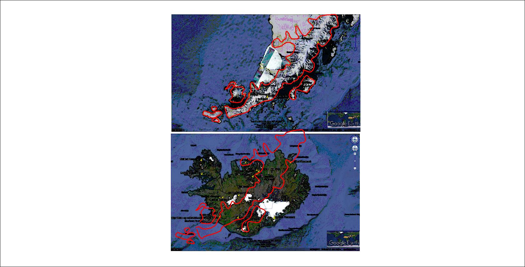
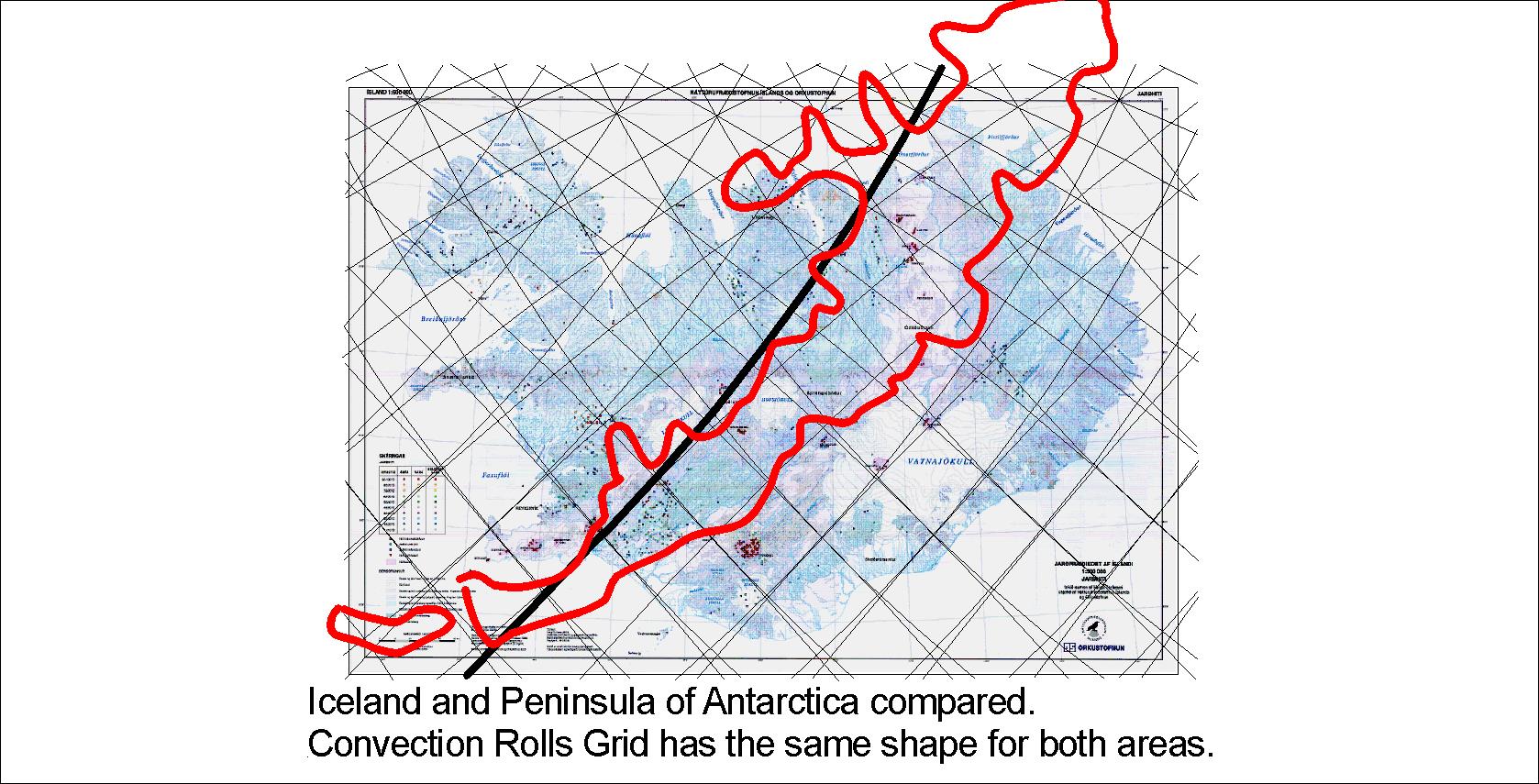
Divisions between Icelandic Plateau and continuations towards Greenland and Faroe Islands marked with red lines.

Within the Iceland region, hotter and weaker continental crust allowed deformation to spread laterally far beyond the widths of the narrower connections to Greenland and the Faroes. Ductile lower-crustal flow, repeated movement of spreading axes and extensive magmatic intrusion may have further smoothed the deformation field. The result could have been a broad, approximately elliptical finite-strain domain.

The Faroe and Greenland ridge segments would then represent narrower continuations of this larger crustal system rather than structures having the same width as the Icelandic central region.

Later tectonic reorganization, especially the development of the Kolbeinsey Ridge, subsequently disturbed the northern part of the original geometry. The most important observation is therefore not merely that the Icelandic shelf is approximately elliptical. It is that the geological boundaries, the central east–west axis, the connections toward Greenland and the Faroes, and the deeper mantle geometry proposed by the convection-roll model appear to form parts of the same symmetric system.

If the continental-crust interpretation is correct, the Icelandic ellipse may record the cumulative deformation of an old continental fragment whose extension was controlled not by a single rift axis, but by a wider and geometrically organized mantle deformation field.

The elliptical outline is particularly evident when compared with the geological and structural maps presented by Hjartarson et al. (2017). Their subdivision of the Greenland–Iceland–Faroe Ridge Complex shows distinct boundaries between the Icelandic shelf and the adjoining Greenland–Iceland and Iceland–Faroe ridge sectors. In particular, the southeastern geological boundary closely follows the elliptical outline described here. The elliptical interpretation itself is not proposed by Hjartarson et al.; it is introduced here as a geometric interpretation of the mapped structures.

The article: Hjartarson, Á., Erlendsson, Ö. & Blischke, A. (2017). The Greenland–Iceland–Faroe Ridge Complex. Geological Society, London, Special Publications, 447, 127–148. DOI: 10.1144/SP447.14.

https://www.researchgate.net/publication/316330629_The_Greenland-Iceland-Faroe_Ridge_Complex