
Antarctica as a Geometrical Reference
The analysis of the Ring of Fire has raised the possibility that its overall form is considerably more regular than is generally apparent, and that its geometry may be controlled by large-scale mantle circulation together with the configuration of adjacent parts of the Earth. This naturally directs attention toward Antarctica, which is itself arranged in a remarkably systematic way around the South Pole.
The division of Antarctica into East and West Antarctica is well established, and the geological boundary between the two passes relatively close to the geographic South Pole. When the entire Antarctic Plate is considered, rather than only the continental landmass, its overall form is elongated and can be approximated by an ellipse. Significantly, the minor axis of this ellipse follows the principal division between East and West Antarctica.
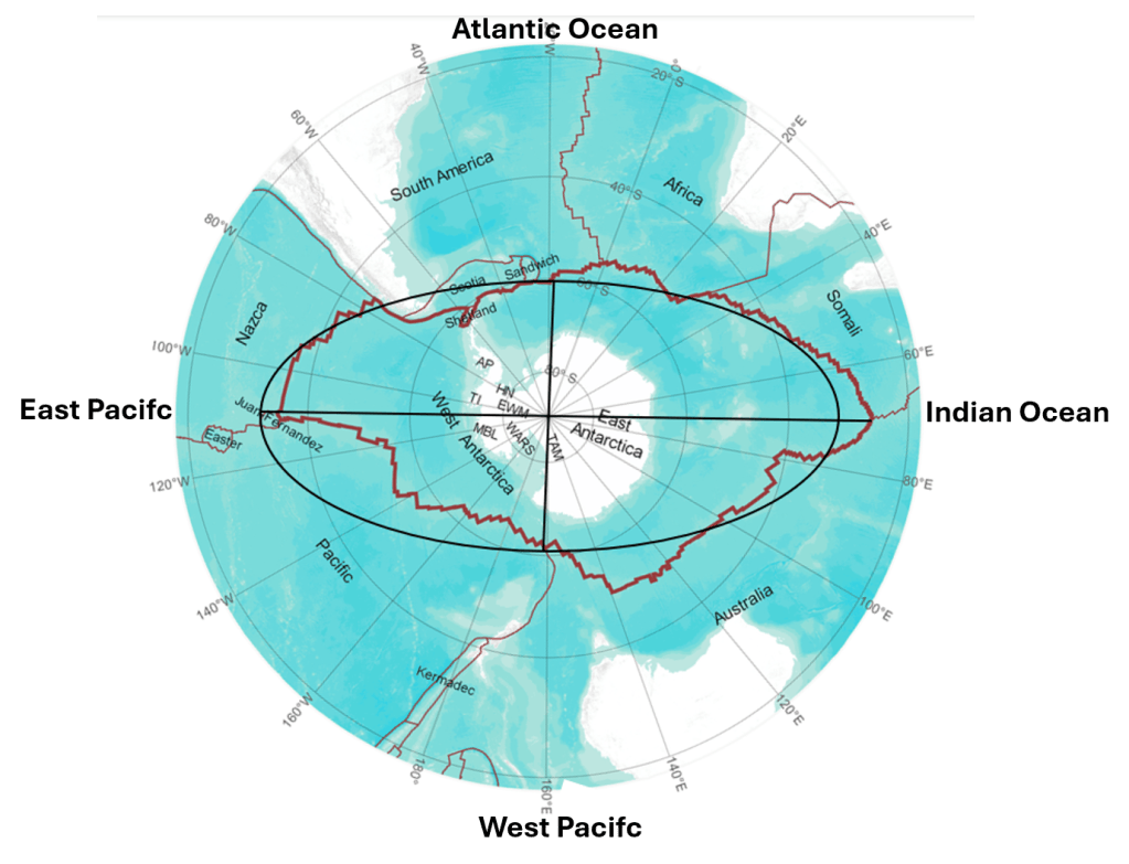
The endpoints of the major axis correspond approximately to the major oceanic-ridge junctions on opposite sides of Antarctica: toward the Indian Ocean ridge system on one side and the East Pacific Rise system on the other.
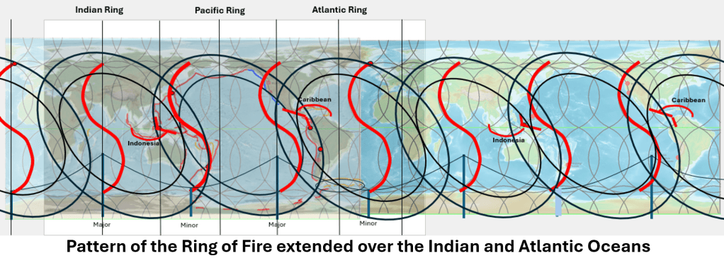
The Mantle Convection Roll Model also corresponds closely with the orientations of the major and minor axes in the western and eastern Pacific sectors surrounding Antarctica. The relevant boundaries intersect these axes near 64°S. A considerable degree of geometrical agreement therefore emerges between the Ring of Fire, the proposed mantle-convection-roll system, and the principal axes of the Antarctic Plate in the southern Pacific region. This relationship is illustrated on the accompanying map.
Extending the Geometry Beyond the Pacific
To examine whether this correspondence represents a broader global pattern, the Atlantic and Indian Ocean regions must also be considered. The inner boundary of the Ring of Fire spans here theoretically 120° from east to west where it crosses the equatorial region. This suggests a simple research hypothesis: if the Pacific system occupies approximately one third of the Earth’s circumference, comparable tectonic rings might occupy the other two 120° sectors.
The first test of this idea can deliberately be kept as simple as possible. A mathematical ellipse is constructed to span 120° at the equator, with its centre positioned 6° south of the equator and with a major-to-minor axis ratio of 1.5. A second, outer ellipse is then constructed around it, spanning 150°, while retaining the same centre. The 150° span corresponds to measureable distance between concrete points along the equator. This provides a straightforward geometry that can be compared directly with mapped tectonic structures. In the Atlantic case, the centre of the proposed elliptical system is placed at approximately 6°S, 29.5°W. The important point is that these parameters are established before detailed geological adjustment. The question is therefore not whether an ellipse can be fitted retrospectively to selected tectonic features, but how well a deliberately simple geometrical construction corresponds to the actual tectonic pattern.
Correspondence with Major Tectonic Structures
When this geometry is plotted on a global map, the agreement with several major tectonic structures appears unexpectedly strong. One of the clearest examples is the Kermadec–Tonga system, which fits naturally into the proposed Indian Ocean Ring. This is particularly significant because Kermadec–Tonga is conventionally regarded as part of the wider Pacific Ring of Fire. In the present model, however, it lies within the sector where the Pacific and Indian Ocean tectonic systems overlap.
A similar relationship appears between the Pacific and Atlantic systems. The Caribbean region and Indonesia occupy broadly corresponding positions at the intersections between the major rings: the Caribbean at the junction between the Pacific and Atlantic systems, and Indonesia at the junction between the Pacific and Indian Ocean systems. Both therefore occupy geometrically comparable positions relative to the proposed mantle-convection-roll framework and to major divisions in the lower mantle. This correspondence is important because the two regions are among the most tectonically complex areas on Earth. Rather than lying randomly within the global pattern, each appears close to a junction between two of the proposed large-scale tectonic systems.
A further complex relationship occurs between South America and Antarctica. The Scotia–Drake Passage–South Sandwich region contains a particularly complicated combination of spreading, transform motion and subduction, yet this system also appears to display symmetry relative to intersection points derived from the mantle-convection-roll geometry.
Overlapping Tectonic Rings
The derivation of these tectonic rings is in several respects more difficult than the derivation of the mantle-convection-roll system itself. The latter concerns an idealized organization within the mantle, whereas the tectonic rings are expressed through lithospheric plates that have evolved, fragmented, rotated and interacted over geological time. The regions where the proposed rings overlap therefore constitute a separate field of investigation.
Nevertheless, it is significant that such a simple initial construction produces such extensive correspondence with mapped tectonic structures. The geometry was not derived independently for each region. Instead, the same basic parameters are repeated around the Earth and then compared with the geology. Considerable work is still required before the system can be defined precisely. Among the factors that must be examined are the geometry of the Earth’s geoid, the use of latitude and longitude on a curved rather than planar surface, and the apparent southward displacement of the tectonic-ring system, which in the present construction places the centres approximately 6° south of the equator.
The distinction between mathematical geometry on a map projection and geometry on the actual surface of the Earth is particularly important. Future calculations should therefore define the ellipses geodetically rather than treating longitude and latitude simply as Cartesian coordinates.
The Red Sea as a Particularly Strong Correspondence
Apart from Kermadec–Tonga, the Red Sea appears to provide one of the clearest correspondences with the tectonic geometry derived from the Ring of Fire. The outer boundary of the proposed Atlantic Ring runs approximately along the central axis of the Red Sea. This is especially interesting because the Red Sea is not merely a geographical depression but an active divergent plate boundary containing an axial spreading system and developing oceanic crust. Its position therefore provides a potentially important test of the model.
The Red Sea relationship also appears to repeat a geometrical pattern observed on the opposite side of the system, along western North America. From the San Andreas region southward through Mexico and the Gulf of California, active plate-boundary structures and spreading centres follow a broadly comparable orientation along the outer margins of the large-scale tectonic ellipses. The corresponding boundary lines are separated by approximately 105°, consisting of 90° between the parallel outer edges of the two elliptical systems plus the intervening 15°-wide tectonically active zone.
The comparison is not intended to imply that these regions have identical tectonic histories. Rather, they appear to occupy corresponding positions and orientations within the larger geometrical framework.
Repeated Ridge Orientations at 90° Intervals
This relationship recalls an earlier observation concerning the Reykjanes Ridge and the Juan de Fuca Ridge. These ridge systems occur approximately 90° apart within the proposed global geometry, yet follow corresponding structural directions. Such repetitions become increasingly important when several independent tectonic features are considered together. A single alignment can readily be coincidental. A repeated combination of alignments, orientations, intersection points and distances is more informative and can be tested quantitatively.
The mantle-convection-roll system also provides a direct geometrical continuation from the minor axis of Antarctica toward the Reykjanes Ridge and Iceland. Thus, Iceland does not appear in this framework merely because it lies on the Mid-Atlantic Ridge. Its position can also be related to one of the principal Antarctic axes and to the wider system of global tectonic divisions.
Multiple Independent Relationships
The resulting pattern is therefore not based on one isolated correspondence. Several different relationships appear simultaneously: The axes of the Antarctic Plate, the geometry of the Ring of Fire, the proposed Atlantic and Indian Ocean Rings, major spreading ridges, major subduction systems, complex plate-boundary junctions, and the mantle-convection-roll divisions all show repeated geometrical relationships.
Previous analysis has also shown that the world’s principal geyser regions can be placed within the same geometrical framework. Iceland, Yellowstone, Kamchatka, New Zealand, Chile and East Africa each occupy positions that can be related to major axes, ring boundaries, intersections or tectonic divisions within the proposed system. This does not by itself establish a common physical cause. It does, however, considerably increase the number of independent geological observations against which the geometry can be tested.
A Working Global Hypothesis
The purpose of the present construction is therefore not to claim that the three tectonic rings have already been demonstrated as physical mantle structures. At this stage they are best regarded as a geometrical research hypothesis derived from the observed form of the Ring of Fire.
The procedure is intentionally simple: First, identify the regularities already present in the Ring of Fire; then construct equivalent geometrical forms at 120° intervals around the Earth; and finally compare those forms with independently mapped tectonic structures.
The surprising result is that the comparison does not produce random relationships. Instead, major structures repeatedly appear close to predicted axes, boundaries, overlaps and intersection zones. If further quantitative analysis confirms these relationships, the three-ring geometry may provide an additional way of examining how the lithosphere is organized above large-scale mantle circulation. The central question is therefore no longer simply why the Pacific Ring of Fire has its familiar form. A broader question arises:
Is the Ring of Fire one visible part of a larger, globally organized tectonic system extending through the Pacific, Atlantic and Indian Ocean regions and geometrically linked to Antarctica and the underlying mantle circulation?


