
The Scotia Arc tectonic system, situated between southern South America and the Antarctic Peninsula, developed during the progressive disruption of the former geological connection between South America and Antarctica. Over tens of millions of years, extension, seafloor spreading, transform motion, subduction and back-arc spreading produced the exceptionally complex tectonic structure that now occupies the Scotia Sea. The system includes the North and South Scotia ridges, the extinct West Scotia Ridge, the active East Scotia Ridge, the South Sandwich volcanic arc and trench, as well as a number of continental fragments and smaller tectonic blocks.
The progressive opening of the region also created the Drake Passage, establishing an oceanic connection between the Pacific and Atlantic sectors of the Southern Ocean. A shallow gateway may already have existed by about 50 million years ago, while a deep-water connection developed later, particularly as seafloor spreading became established in the West Scotia Sea between about 34 and 30 Ma. This opening eventually allowed circumpolar ocean circulation to develop around Antarctica. The Antarctic Circumpolar Current profoundly influences the transfer of heat between Antarctica and lower latitudes and contributed to the increasing thermal isolation of the continent.
What is particularly interesting in the present study, however, is the geometry of the entire tectonic system. Although the Scotia Arc is conventionally described as an arcuate tectonic structure, its principal ridges, plate boundaries and subduction systems can, in the geometrical interpretation developed here, be contained within an approximately elliptical large-scale form. The minor-axis meridian of this ellipse lies at approximately 49.7°W.
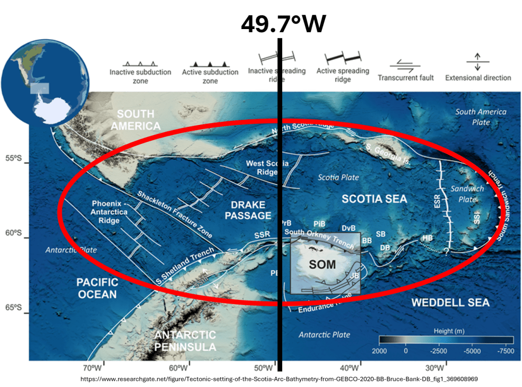
This position is especially notable when compared with the elliptical form previously identified around the Icelandic shelf, whose corresponding minor-axis meridian lies at approximately 19.7°W.
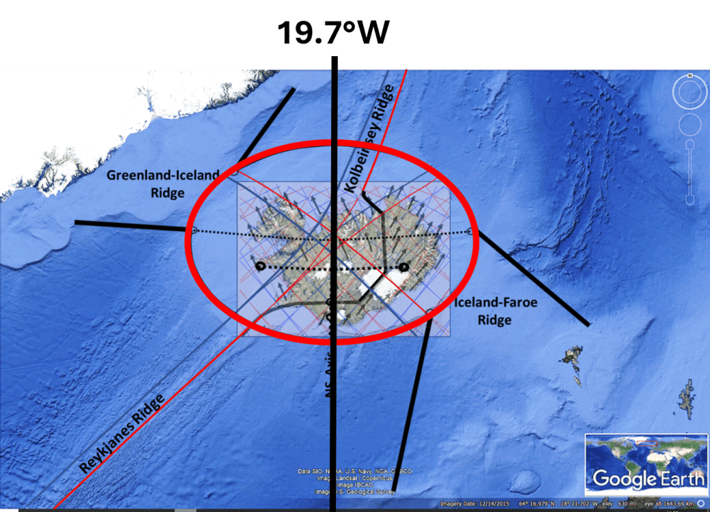
The difference is almost exactly: 49.7°W − 19.7°W = 30.0°
Thus, the central axes of two geographically remote and tectonically very different regions fall on meridians separated by exactly 30° of longitude within the proposed mantle convection-roll framework.
This comparison does not imply that Iceland and the Scotia Arc formed through the same tectonic processes. Iceland lies on an active divergent plate boundary associated with the Mid-Atlantic Ridge, whereas the Scotia Arc contains a much more complicated combination of transform boundaries, extinct and active spreading centres, back-arc extension and subduction. What is being compared here is therefore not the detailed tectonic mechanism, but the large-scale geometry and its position within the proposed global convection-roll system.
This distinction makes the correspondence more interesting rather than less: two very different tectonic systems appear to be organised within similarly defined large-scale geometrical frameworks.
Iceland and the Antarctic Peninsula
There is another useful reason for making this comparison. Iceland lies between approximately 63° and 67°N, while the northern Antarctic Peninsula occupies broadly corresponding latitudes in the Southern Hemisphere. We therefore have exposed land at approximately equivalent absolute latitudes on opposite sides of the Earth, allowing some geometrical relationships to be compared directly.
An earlier comparison was presented here:
Iceland and Antarctic Peninsula compared
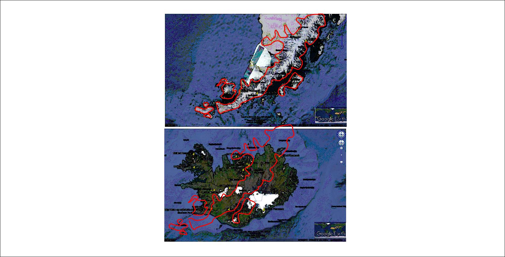
When the outline of the Antarctic Peninsula is transferred to the Iceland region according to corresponding positions within the proposed convection-roll framework, an intriguing relationship appears. The trend of the Antarctic Peninsula follows closely the principal division line of the North Atlantic tectonic system where that line crosses Iceland.
The same relationship can be shown on the geological map base of the Icelandic Institute of Natural History and the National Energy Authority:
And when the corresponding Antarctic line is added:
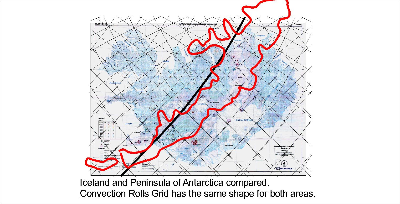
The geometrical agreement is striking. It should not, however, be interpreted simply as a similarity in coastline shape. The proposed explanation is that both regions occupy corresponding positions relative to the same large-scale system of mantle convection rolls. If the underlying geometrical controls are comparable, some similarity in the orientation of tectonic structures at the surface would be expected.
The new comparison with the entire Scotia Arc adds an important dimension to this earlier observation. The minor axis of the proposed Icelandic ellipse follows approximately 19.7°W, whereas the corresponding axis through the Scotia Arc system follows approximately 49.7°W. The two are therefore separated by 30° of longitude, one of the fundamental longitudinal intervals identified in the convection-roll model.
The Antarctic Peninsula extends away from the Scotia system in a position that can consequently be compared with Iceland after applying this 30° longitudinal relationship. When the two regions are superimposed according to that geometry, the Antarctic Peninsula follows a trend comparable to the principal tectonic and volcanic division across Iceland.
There is also a suggestive mirror-like aspect to the comparison. From its connection with the Scotia Arc, the Antarctic Peninsula extends predominantly southward, while the principal volcanic zones of Iceland extend through the Icelandic shelf in a broadly corresponding geometrical arrangement. The comparison is not exact at the level of individual faults or volcanic centres, nor should it be expected to be. The significant feature is the correspondence of the large-scale axes, orientations and longitudinal positions.
This gives the Scotia Arc–Iceland comparison particular importance within the model. It is not an isolated match between two selected geological features. Rather, the 30° separation between the two central meridians occurs in addition to numerous other cases in which major geological structures appear to coincide with the regular longitudinal framework predicted by the mantle convection-roll system.
The Scotia Arc therefore provides an unusually useful test area. Its tectonic history is independently well established, its internal structure is exceptionally complex, and yet the system as a whole can be examined geometrically. If such a complex assemblage of spreading ridges, transform boundaries, subduction zones and volcanic arcs is nevertheless organised within the predicted large-scale framework, the correspondence deserves closer investigation.
The geological features found at these corresponding latitudes in the Southern and Northern Hemispheres appear, to some extent, to mirror one another.
The broadly elliptical Scotia Arc tectonic system can be compared with the elliptical outline of the Icelandic shelf, while the volcanically active Antarctic Peninsula may likewise be compared with the volcanic regions of Iceland.
The two areas are by no means identical. Their geological settings are fundamentally different, not least because the Antarctic Peninsula is strongly influenced by the presence and tectonic history of the Antarctic continent, whereas Iceland is surrounded by oceanic crust and lies astride an active mid-ocean ridge system.
Nevertheless, the comparison is presented here because the large-scale mirroring effect is difficult to overlook. Despite the very different geological environments, the overall geometry, orientation and position of the principal tectonic and volcanic features show a striking degree of correspondence.


