
Summary
Measurements and mapping have provided a foundation for scientific progress for centuries. This article seeks to relate available information on Earth’s internal layering, the properties of convection currents, Earth’s spherical geometry, and its rotation to the distribution of geological activity at its surface.
The analysis assumes that slow heat transport in Earth’s mantle may, under certain conditions of dynamic equilibrium, produce a regular system of convection rolls. By comparing the dimensions of Earth’s internal layers with the geometry of such rolls, a model is developed for their vertical and horizontal arrangement. Their horizontal positions are then described by mathematical curves that can be compared with volcanic belts, fissure swarms, and plate boundaries.
Iceland serves as the initial study area. A comparison of calculated convection-roll boundaries with the country’s geological structure provides a basis for investigating relationships among mantle convection, divergence, and the orientation of fracture systems.
The model is subsequently extended to a global comparison. Particular attention is given to whether the arrangement of convection rolls in the lower mantle could be associated with three principal zones of influence separated by 120° of longitude. The hypothesis is advanced that this arrangement may be related, among other factors, to the transfer of heat from the outer core across the core–mantle boundary. On this basis, three tectonic rings are defined: the Pacific Ring, associated with the so-called Ring of Fire; the Atlantic Ring; and the Indian Ocean Ring. Each is represented by a belt between two ellipses sharing a common center and principal orientation.
The objective of the article is to examine whether a common geometric and mechanical model can shed further light on relationships among upwelling, downwelling, divergence, subduction, and horizontal plate motions.
Abstract
Measurements and geographical mapping have provided a foundation for scientific progress over many centuries. This paper explores possible relationships between Earth’s internal layering, the geometry of mantle convection, planetary rotation, and the global distribution of tectonic activity. The proposed Convection Rolls Model assumes that slowly evolving mantle convection may develop a regular arrangement of elongated convection cells under particular conditions of dynamic balance. Their dimensions are compared with the internal structure of Earth, and their horizontal geometry is represented by mathematical curves that can be examined against volcanic zones, fracture systems, and plate boundaries.
Iceland provides the initial regional example. The calculated orientations of convection-roll boundaries are compared with the geometry of its divergent plate boundary and associated volcanic systems. The analysis is subsequently extended to the global scale. Three principal tectonic regions are proposed, separated by 120° in longitude and tentatively associated with large-scale thermal organization near the core–mantle boundary.
These regions are represented by three paired elliptical belts: the Pacific Ring, associated with the familiar Ring of Fire, the Atlantic Ring, and the Indian Ocean Ring. Their overlapping geometry is examined in relation to divergent, convergent, and transform plate boundaries.
The proposed framework seeks to connect the vertical transport of heat and matter within Earth with the horizontal organization of lithospheric deformation. Its geometric relationships provide hypotheses for testing against independent geophysical and geological observations.
1. Introduction
Heat is continuously transferred from Earth’s interior to its surface and from there into space. This transfer of heat is one of the fundamental processes underlying the activity that shapes Earth’s surface. Heat may be transferred in three ways: conduction, radiation, and mass transport. In Earth’s mantle, much of the heat transfer occurs through convection, in which material moves in response to differences in density caused, among other things, by variations in temperature.
The mantle consists predominantly of solid rock, but under the high pressures, temperatures, and long timescales that prevail there, its material can deform and flow very slowly. These motions therefore differ from those in ordinary liquids, although several fundamental principles of fluid mechanics remain applicable. William Thomson, later Lord Kelvin, once calculated that Earth could not have been cooling for more than a few tens of millions of years. His calculation did not take account of heat production by radioactive elements, which was subsequently recognized as an important factor in explaining Earth’s thermal history.
Earth has several sources of heat. They include heat retained from its formation, heat generated through radioactive decay, and heat transferred from the core into the mantle. Earth’s cooling and the movement of heat within it affect the density, viscosity, and motion of mantle material. When mantle material is heated, its density generally decreases relative to cooler material at comparable pressure. It may therefore become buoyant and rise. Cooler material is correspondingly more likely to sink. Under these conditions, motions can develop that form circulatory patterns or convection rolls.
These movements operate over such long periods that it is reasonable to ask whether they may develop a regular organization. Equilibrium need not imply that the system is stationary. Rather, it may constitute a dynamic balance in which motion continues while some of its principal features remain relatively stable. This line of thought led to the development of a mathematical model referred to here as the Convection Rolls Model of Earth.
The initial objective was to investigate whether the positions and orientations of Iceland’s volcanic belts could be explained in terms of Earth’s internal structure. Subsequent analysis suggested that the approach might be extended to plate boundaries on a global scale. This development raises a new research question:
Could the same internal system of convection rolls influence both divergent and subduction zones, and could those influences be reflected in a regular global distribution of tectonic activity?
2. Assumptions Underlying the Convection Rolls Model
The calculation of possible positions and orientations of convection rolls in Earth’s mantle rests on three main considerations:
- Earth’s internal layering and the measured boundaries between its principal layers.
- The properties of convection currents and the geometric forms they can produce.
- The geometry of horizontal movements on a spherical surface and the possible influence of Earth’s rotation on their organization.
The theoretical background includes studies of convection and the formation of elongated convection rolls, as discussed by Manneville (2010), and studies of inertial trajectories on a rotating sphere by Paldor and Killworth (1988). Walzer (1971) has also discussed relationships between mantle convection and large-scale features of Earth’s topography. Convection experiments can produce regular, elongated rolls. Under certain conditions their cross sections approach equal height and width. That geometry is used here as a reference in constructing the model. The model assumes that, over long periods, mantle motions may tend toward a relatively efficient configuration in which buoyancy, gravity, viscosity, and other forms of resistance interact.
It is important, however, to distinguish this assumption from a demonstration that actual convection rolls within Earth possess precisely this geometry. Mantle properties are complex and depend, among other things, on temperature, pressure, composition, and strain rate. Similarly, a geometric comparison with inertial trajectories on a rotating sphere must be distinguished from a direct mechanical description of mantle convection. In conventional models of slow mantle flow, Coriolis forces are considered very small in comparison with gravitational and viscous forces. Applying such trajectories to mantle convection is therefore a specific research assumption of the present model and requires further physical justification.
With this qualification, a geometric framework can nevertheless be formulated and tested for measurable correspondence with Earth’s geological structure.
3. Earth’s Internal Layering and the Dimensions of Convection Rolls
Earth’s internal structure is known to a considerable extent from seismological measurements. These reveal, among other boundaries, those between the crust, mantle, outer core, and inner core. In 1936, Inge Lehmann demonstrated the existence of Earth’s inner core. Its radius is approximately 1,221 km, giving it a diameter of about 2,442 km. The outer core extends from a depth of approximately 2,900 km down to the inner core. The mantle lies between the crust and the outer core. Within the mantle, seismic observations reveal important changes in wave velocity at depths of approximately 410 and 660 km. These discontinuities are primarily associated with pressure-induced changes in mineral crystal structure.
The Convection Rolls Model places particular emphasis on comparing the thicknesses of these layers with possible dimensions of circulating flow units.
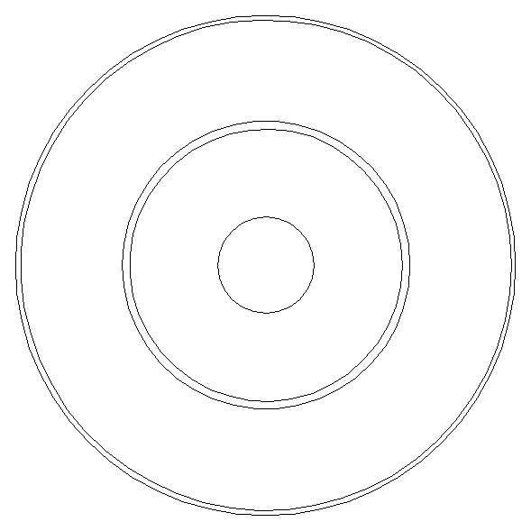
Figure 1. Cross section of Earth showing the inner core, outer core, lower mantle, upper mantle, and lithosphere. The inner core has a radius of approximately 1,221 km.
3.1. The Larger Convection Rolls
If a regular circulating flow is assumed within the lower mantle, it is possible to investigate whether the dimensions of the convection rolls could be related to the thickness of the layer they occupy. The model assumes that two layers of convection rolls may be stacked between depths of approximately 670 and 2,900 km. On this basis, 24 major units are proposed around Earth, each spanning 15° of longitude on the model’s coordinate grid. Two neighboring units then form a combined circulation spanning 30°.
Thus:
24 × 15° = 360°
Alternatively, there are 12 combined pairs, each spanning 30°. This division becomes important when considering how upwelling and downwelling may alternate within the system.
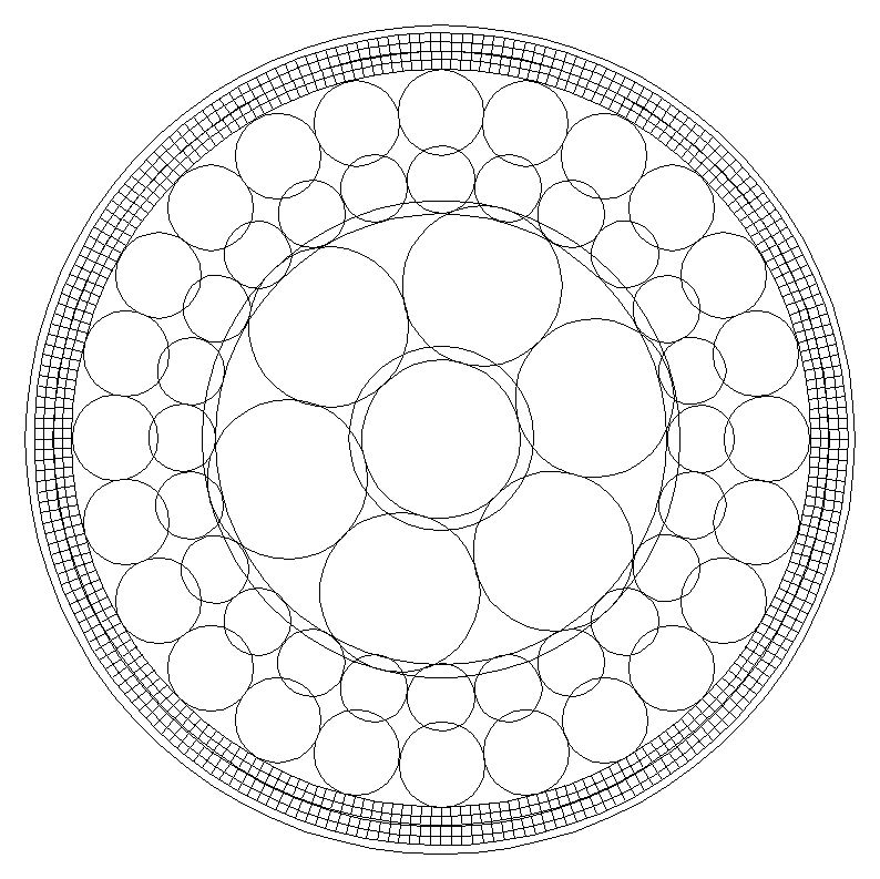
Figure 2. Cross section of Earth showing two layers of large convection rolls in the lower mantle. Upwelling and downwelling are shown on opposite sides of the combined units.
3.2. The Smaller Convection Rolls
Much smaller units are considered in the upper mantle.
In the Convection Rolls Model, the interval from approximately 120 to 410 km depth is divided into two layers. Likewise, the interval from approximately 410 to 670 km depth is divided into two layers, although the lower boundary of the mantle transition zone is generally measured at approximately 660 km.
The model thus assumes a total of four layers of smaller convection rolls. If each unit spans 1.5° of longitude on the coordinate grid, there are 240 units in each layer:
240 × 1.5° = 360°
A notable consequence is that ten smaller units correspond to the width of one larger unit:
10 × 1.5° = 15°
This establishes a regular geometric correspondence between the proposed convection-roll systems of the upper and lower mantle. This arrangement is one of the model’s central assumptions. It does not, however, follow directly from seismic measurements. Further investigation is required to determine whether actual variations in viscosity, density, and flow conditions could produce such regular units.
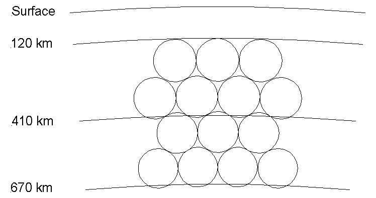
Figure 3. Arrangement of convection rolls in the upper mantle. Two layers are shown between 120 and 410 km depth, and two between 410 and 670 km, together with their mathematical relationship to the larger units of the lower mantle.
4. Horizontal Geometry of the Convection Rolls
The vertical arrangement of convection rolls does not by itself establish their positions at Earth’s surface. Their horizontal orientation must also be described. The Convection Rolls Model assumes that horizontal flow may follow regular curved paths that change direction with increasing distance from the equator. A particular mathematical construction represents these trajectories as circles in a coordinate system of longitude and latitude. The calculations are based on a combined 30° unit at the equator and a reference condition relating the size of a horizontal circular path to Earth’s radius.
Under the model’s assumptions, the center of each circular trajectory lies at approximately 32° north or south latitude. The radius of the circle in the coordinate system is:
r = √(32² + 15²) = 35.34°
The equation for a circular trajectory in the Northern Hemisphere is therefore:
(λ − Cₙ)² + (φ − 32°)² = (35.34°)²
where:
- λ denotes longitude;
- φ denotes latitude;
- Cₙ is the longitudinal coordinate of the center of the relevant trajectory.
The centers are spaced at intervals of 1.5° when the smaller convection rolls are plotted, and at 15° intervals when only the principal lower-mantle arrangement is shown. The corresponding trajectory in the Southern Hemisphere has its center at 32°S:
(λ − Cₙ)² + (φ + 32°)² = (35.34°)²
Together, these trajectories form a regular network over much of the planet.
It is important to emphasize that these are circles in a flat longitude–latitude coordinate grid. They are not necessarily circles defined by equal surface distances on Earth, because the distance represented by one degree of longitude decreases toward the poles.
Accurate comparisons with geological orientations and distances must therefore account for this spherical-geometric variation.
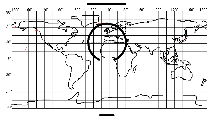
Figure 4. Horizontal trajectory of convection rolls in a longitude–latitude coordinate system. The center at 32°N, the radius of the trajectory, and its relationship to a 30° unit at the equator are shown.
4.1. Boundaries at 64° Latitude
The model assumes that a different arrangement of convection rolls takes over closer to the poles.
In the Northern Hemisphere, the centers of these trajectories lie at 96°N in an extended coordinate system:
(λ − Cₙ)² + (φ − 96°)² = (35.34°)²
The corresponding Southern Hemisphere trajectories have their centers at 96°S:
(λ − Cₙ)² + (φ + 96°)² = (35.34°)²
These trajectories connect with those at lower latitudes in the vicinity of 64°N and 64°S.
According to the model, four principal belts of horizontal trajectories are thereby distinguished:
- From the equator to 64°N, where westward trajectories dominate the principal representation.
- From 64°N to the North Pole, where eastward trajectories take over.
- From the equator to 64°S, where eastward trajectories dominate.
- From 64°S to the South Pole, where westward trajectories take over.
This division forms part of the model’s geometric representation. It is not an independent measurement of actual mantle-flow directions. The boundary at 64° latitude has particular importance for the analysis of Iceland, as discussed below.
5. The Convection Rolls System and the Geology of Iceland
Iceland occupies a distinctive position among Earth’s volcanic regions. The country lies on the divergent boundary between the North American and Eurasian plates, where the Mid-Atlantic Ridge rises above sea level. Both vertical and horizontal motions occur there. Mantle material rises, magma is generated through decompression melting, new crust is added, and the tectonic plates move apart. The volcanic belts, however, do not follow a single straight line. On the Reykjanes Peninsula and in the Western Volcanic Zone, fissure swarms have orientations that differ from those across much of the Eastern Volcanic Zone. The Northern Volcanic Zone also has a distinctive structure, particularly north of the central highlands. The Convection Rolls Model seeks to compare these orientations with calculated boundaries between convection rolls.
5.1. Volcanic Belts South of 64–65°N
In southern Iceland, the calculated boundaries of the convection rolls form large, relatively regular diamond-shaped patterns. In the model, these patterns are associated with the interaction of two directional influences: the calculated organization of the convection rolls and the horizontal divergence of the tectonic plates. The Eastern Volcanic Zone, extending in part from Hekla and the Laki fissures northward toward Vatnajökull and Kverkfjöll, is of particular interest in this comparison. Important portions of this volcanic zone have orientations similar to certain lines in the convection-roll system. The model proposes that correspondence between these orientations might influence the distribution of divergence among individual fissure swarms. This does not imply that every fracture or volcano directly follows a single convection-roll line. On the contrary, interactions among several kinds of motion may produce complex structures.
5.2. Changes at 64–65°N
The calculated arrangement of convection rolls changes substantially toward 64–65°N. Here, trajectories associated with lower latitudes approach those of the polar system. Changes in the arrangement of Iceland’s volcanic belts are also observed in nature. Large diamond-shaped patterns and oblique fracture systems are common in the south, whereas north–south orientations become more prominent farther north, including in the Northern Volcanic Zone from Kverkfjöll and Askja toward Öxarfjörður.
According to the Convection Rolls Model, this transition could be associated with a change in the geometric organization of mantle convection at similar latitudes. This is one of the hypotheses that can be tested by detailed comparison with mapped fractures and measured plate motions.
5.3. The South Iceland Seismic Zone
The South Iceland Seismic Zone is another important study area. It contains strike-slip movements and fracture systems that cannot be explained by simple divergence alone. In the Convection Rolls Model, the calculated roll boundaries form diamond-shaped patterns that can be compared with the orientations of different fracture sets. Such comparisons may be useful when examining relationships among plate motions, the stress field, and the distribution of individual fracture systems. The measured properties of the seismic zone must nevertheless be distinguished from the forms generated by the mathematical model. In particular, the model must be compared with measured strike-slip orientations and interconnected fracture systems.
5.4. Iceland as Part of a Larger System
The analysis of Iceland was originally the primary focus of the Convection Rolls Model. It sought to show how calculated trajectories of internal Earth motions might correspond to the positions and orientations of geological features in a relatively small area. If the model has general validity, however, studying Iceland alone is insufficient. The same principles must be examined in relation to other divergent zones, subduction zones, transform faults, and volcanic systems. This question leads from the geology of Iceland to global plate tectonics.
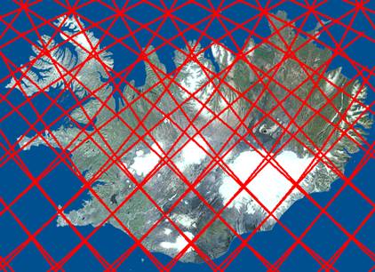
Figure 5. Calculated convection-roll boundaries across Iceland. The change in pattern at 64–65°N is shown alongside the volcanic belts and major fracture systems.
6. From Local Divergence to a Global Plate System
Plate tectonics describes the motions of lithospheric plates and their positions relative to one another. At divergent boundaries, plates move apart and new oceanic crust may form. At convergent boundaries, plates collide and oceanic lithosphere may descend back into the mantle. At transform boundaries, plates move laterally past one another.
These three principal types of plate boundary are closely related. New crust is continuously produced along the Mid-Atlantic Ridge and other oceanic ridges. Over long periods, this production must be considered alongside subduction and crustal recycling elsewhere. Many of today’s most important subduction zones are situated around the Pacific Ocean. They form a large part of the region commonly known as the Ring of Fire.
The discussion therefore turns to two major aspects of the same global process: the creation of new crust at divergent boundaries and the return of oceanic crust to the mantle through subduction. Such an analysis must include both vertical and horizontal movements. At divergent boundaries, mantle material rises and also spreads laterally. At subduction zones, cooler and denser oceanic lithosphere descends into the mantle, potentially modifying the flow of surrounding mantle material. At transform boundaries, lateral displacement occurs without necessarily producing or destroying significant amounts of crust at the boundary itself.
The question is whether these different phenomena might be described as local expressions of a larger system of motion. This does not disregard recognized forces such as slab pull, gravity-driven motions associated with oceanic ridges, or forces connected with mantle flow. Rather, the objective is to investigate whether a common internal geometry can help explain how these forces are distributed.
7. A Threefold Organization of the Lower Mantle and Its Relationship to the Outer Core
When the calculated boundaries of lower-mantle convection rolls are plotted on a world map, a regular pattern appears at intervals of 15°. If only selected major units are displayed, a simple pattern extending around the globe becomes apparent. Within this arrangement, three principal longitudinal regions can be identified and associated with active areas in or near Iceland, Hawaii, and western Indonesia. These three regions invite consideration of whether the global organization of heat transport may have a threefold character.
7.1. The Role of the Outer Core
Earth’s outer core consists predominantly of liquid, iron-rich material. Movements occur there because of thermal and compositional differences. These motions are fundamental to the process that maintains Earth’s magnetic field. The mantle lies above the outer core, separated from it by the core–mantle boundary (CMB) at a depth of approximately 2,900 km. Substantial heat can be transferred across this boundary from the core to the mantle.
Heat flow across the boundary need not be uniform. Uneven distribution of heat can affect temperature, density, and upwelling in the lowermost mantle. This raises the possibility of a connection between motion in the outer core and the convection-roll system in the mantle.
7.2. Three Principal Upwelling Pathways
As an extension of the Convection Rolls Model, the hypothesis is proposed that, at a large scale, the outer core may be conceptualized as containing three principal upwelling pathways and three principal downwelling pathways. Such an arrangement would consist of six interacting sectors of a circulating flow system. At the core–mantle boundary, this organization might influence the distribution of heat entering the lower mantle. The model does not assume that outer-core material flows directly upward through the mantle. The proposed connection concerns primarily heat transfer and its possible influence on motions within the solid mantle.
The mantle is very thick, and influences originating at the CMB may spread, change, and interact with other flow systems before being expressed closer to the surface. Nevertheless, the research hypothesis advanced here is that such a threefold arrangement may be reflected in three major regions of influence at the global scale.
In the model, these are associated with areas near Iceland, Hawaii, and Indonesia. They are not defined as three precise points at which upwelling from the core has been measured. Instead, they are reference regions for further comparison of the geographical and geometric organization of tectonic activity.
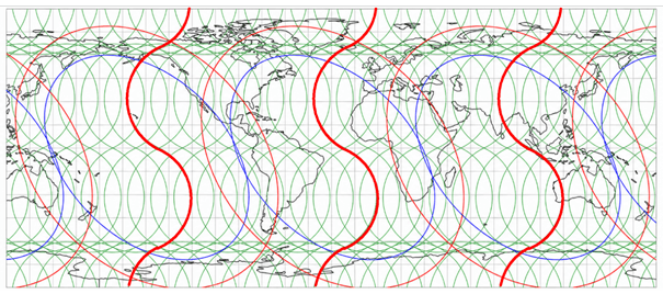
Figure 6. World map showing lower-mantle convection-roll boundaries at 15° intervals. Three principal regions of influence are highlighted, together with their proposed relationships to the central meridians of the tectonic rings.
8. Three Tectonic Rings
One of the main new elements of the analysis is the proposal that the global distribution of active plate boundaries may be compared with three extensive elliptical regions.
These are designated as:
- The Pacific Ring, or Ring of Fire.
- The Atlantic Ring.
- The Indian Ocean Ring.
The three rings are defined by the same fundamental geometric dimensions, but their centers are separated by 120° of longitude. Dividing the 360° circumference of Earth into three equal parts gives:
360° / 3 = 120°
Moreover, 120° is an integer multiple of the 15° subdivision of the larger lower-mantle convection rolls:
120° = 8 × 15°
The threefold global arrangement can therefore be related geometrically to the same fundamental division used in the Convection Rolls Model. This numerical correspondence does not, in itself, demonstrate that the rings are generated by the convection rolls. Establishing that connection requires a mechanical explanation and comparison with geological observations.
8.1. Mathematical Geometry of the Rings
In the model, each tectonic ring is defined by two ellipses. The inner ellipse has the following semi-axes:
- Semi-major axis: 77.7° (units).
- Semi-minor axis: 51.8° (units).
Their mathematical ratio is:
77.7 / 51.8 = 1.5
Thus, the ratio of the major to minor axes of the inner ellipse is exactly 3:2.
The outer ellipse has the following semi-axes:
- Semi-major axis: 96.5° (units).
- Semi-minor axis: 71° (units).
Their ratio is approximately 1.36.
The principal axes of both ellipses are tilted by 45° on the longitude–latitude coordinate grid. The major axis extends from northwest to southeast, while the minor axis runs perpendicular to it, from southwest to northeast.
The centers of all three rings are situated at 6°S.
Their central longitudes are:
- Atlantic Ring: 30.5°W.
- Indian Ocean Ring: 89.5°E.
- Pacific Ring: 150.5°W.
The centers are therefore separated by exactly 120° when measured around Earth.
On a flat coordinate grid, the ellipses may be described by the following transformation:
u = (Δλ − (φ + 6°)) / √2
v = (Δλ + (φ + 6°)) / √2
where Δλ is the longitudinal difference from the center of the relevant ring.
The equation of the ellipse is then:
u²/a² + v²/b² = 1
where a is the semi-major axis and b is the semi-minor axis.
This formulation makes it possible to calculate ring boundaries on the map grid and compare them with the locations of geological features.
Because degrees of longitude and latitude do not represent equal distances everywhere, the shape on a coordinate map must be distinguished from the shape on the spherical surface. Particular care is needed when interpreting ellipses near the poles or across the 180° meridian.
8.2. Inner and Outer Boundaries
The inner ellipse defines one principal reference boundary of the region of influence, and the outer ellipse defines the other. The region between them is referred to here as the tectonic ring. This does not imply that all parts of the ring are equally active or that geological boundaries exactly follow the ellipses. Some regions may be characterized by divergence, others by subduction, and still others by transform motion. The width of the ring also varies. Because the inner and outer ellipses do not have precisely the same axis ratios, the belt between them is not of uniform width.
In this coordinate representation, the inner ellipse spans approximately 120° along the equator. The outer ellipse extends over a much greater range of longitude and therefore overlaps more extensively with neighboring rings. The result is a system of three adjacent and partly overlapping regions of influence.
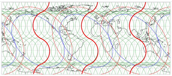
Figure 7. Mathematical map of the three tectonic rings. Inner and outer ellipses are shown on a longitude–latitude coordinate grid without a basemap. Their centers lie at 6°S and are spaced 120° apart.
9. The Pacific Ring and the Ring of Fire
The Ring of Fire around the Pacific Ocean is one of the best-known features of Earth’s geology.
It consists of extensive zones of earthquakes, volcanism, and subduction, extending along the western coast of South America, through Central America and western North America, Alaska, the Aleutian Islands, Kamchatka, Japan, Indonesia, and southward to New Zealand.
It is not a continuous ring in the conventional geometric sense, but a belt composed of numerous distinct yet connected plate boundaries.
Large portions of the region contain subduction zones where oceanic plates descend beneath other plates. Elsewhere, transform movements and other plate-boundary types occur. The Convection Rolls Model places the Ring of Fire in a broader context. The Pacific Ring is defined as an elliptical region of influence centered at 149.3°W and 6°S.
Within that region, it is possible to investigate whether the distribution of plate boundaries is related to the inner boundary, the outer boundary, the axes, or other properties of the ellipse.
9.1. California and the San Andreas Fault
The San Andreas Fault is one of the world’s best-known transform faults. It forms part of the boundary between the Pacific and North American plates. In the elliptical model, attention is directed, among other places, to the central sectio of the San Andreas Fault near 36.4°N, 121°W. There, the orientation of the fault can be compared with the inner boundary of the Pacific Ring.
The Gulf of California and the Salton Sea region also provide important reference areas for examining the northern part of the ring. The comparison concerns not only the proximity of individual points to the ellipse, but also whether the orientation of the plate boundary corresponds to the tangent of the calculated curve. This approach provides more testable quantities than a simple comparison of locations.
9.2. New Zealand and Overlapping Rings
New Zealand occupies a distinctive position where extensive plate-boundary systems meet in the southwestern Pacific. The Alpine Fault on the South Island is one of the region’s most important strike-slip faults. The model investigates whether its location is related to the minor axis of the Pacific Ring, as well as to areas where the proposed rings overlap. The relevant comparisons concern both the geometric position of plate boundaries and whether calculated convection-roll trajectories have corresponding orientations.
This location is of particular interest because of its relationship to other active plate boundaries near New Zealand, including the Tonga–Kermadec subduction zone.
9.3. Hawaii and the Central Meridian of the Ring
Hawaii differs from these examples. Its volcanoes lie within the Pacific Plate, far from its major plate boundaries. In the model, Hawaii is not primarily associated with the boundary of the ellipse, but with the principal north–south meridian running through the center of the Pacific Ring.
On one hand, a region of influence is associated with the center of the system and possible mantle upwelling. On the other, the elliptical boundaries are compared with the distribution of lateral stress and deformation zones. Volcanoes within plates and tectonic activity along plate boundaries may therefore occupy different geometric categories within the same research model.
10. The Atlantic Ring
The Atlantic Ring constitutes the second major component of the threefold system. Its center is at 29.3°W and 6°S. Unlike much of the Pacific Ring, the Atlantic Ocean is characterized primarily by divergence. The Mid-Atlantic Ridge extends from the northern oceans southward through the Atlantic, forming boundaries between major tectonic plates. New oceanic crust is continuously formed along it. Iceland is one of the clearest examples of this activity, since the ridge emerges above sea level there.
10.1. Iceland in a Global Context
When the Atlantic Ring is superimposed on a world map, its mathematical geometry can be compared with the position of the Mid-Atlantic Ridge and other active regions. This places the earlier analysis of Iceland’s volcanic belts in a new context. The convection rolls previously compared with fracture orientations in Iceland are now considered as part of a much larger system. Iceland consequently becomes not only a regional example of divergence but also a reference area for investigating the global distribution of heat and stress. Particular attention may be given to Iceland’s position relative to other principal regions of influence, including Hawaii. Their longitudes differ by approximately 90°, suggesting a further comparison with the regular organization of the convection-roll system.
10.2. The Red Sea and East Africa
According to the elliptical model, the Atlantic Ring extends beyond the Atlantic Ocean itself. Areas considered in this context include the Red Sea and the East African Rift System. The Red Sea is a divergent zone where the Arabian Plate is moving away from Africa. In the model, its position may be compared with the outer boundary of the Atlantic Ring. It is particularly interesting to examine whether the geometry there has any relationship to comparable features in the Gulf of California, where divergence and transform motion are also associated with long, relatively narrow marine basins.
This comparison does not imply that the two regions formed in the same way or are at the same stage of development. The objective is to examine whether larger-scale geometric factors may affect their orientations.
10.3. The Galápagos Islands and Overlap with the Pacific
The Galápagos Islands provide another interesting study area. They lie near plate boundaries in the eastern Pacific, where both divergence and the movements of oceanic plates are involved. In the elliptical model, this region may be compared with the margins of the Atlantic and Pacific rings. Such overlap becomes particularly interesting if it can be linked to the orientation and activity of measured plate boundaries.
11. The Indian Ocean Ring
The third ring is the Indian Ocean Ring, centered at 90.7°E and 6°S. The Indian Ocean contains an extensive system of oceanic ridges forming interconnected divergent boundaries. These involve the motions of several major plates and the formation of new oceanic crust. The Indian Ocean Ring, however, is not limited to the divergent boundaries within the Indian Ocean. According to the elliptical model, its region of influence also extends into parts of Asia, Indonesia, and the southwestern Pacific.
11.1. Indonesia and Subduction Zones
Indonesia is one of Earth’s most active volcanic regions. Several tectonic plates and extensive subduction zones converge there. Krakatau, or the Krakatau volcanic system, is among the features that can be used for geographical comparisons within the Convection Rolls Model. In the threefold hypothesis, western Indonesia is associated with one of the principal regions of influence in the proposed heat-transfer system.
The region also lies partly within the area where the Pacific and Indian Ocean rings meet.
This overlap provides an opportunity to investigate whether more than one large-scale directional or stress influence is present.
11.2. Tonga–Kermadec and the Southwestern Pacific
The Tonga–Kermadec belt is one of Earth’s most active subduction zones. There, the Pacific Plate descends beneath an adjacent plate system, and subduction is associated with extension in back-arc regions. This is an important study area for the Convection Rolls Model because three factors can be compared:
- The downward movement of the subducting oceanic plate.
- Lateral movements and extension behind the subduction zone.
- The calculated geometry of the convection rolls and tectonic rings.
This offers an opportunity to test whether interactions between subduction and mantle flow are more complex than the simple relative movement of two rigid plates. Conventional explanations consider, among other factors, slab pull, migration of the subduction boundary, and flow of mantle material around the slab.
The Convection Rolls Model proposes an additional perspective, investigating whether the positions and orientations of calculated convection rolls can influence this development.
12. Overlapping Rings and the Mechanics of Plate Boundaries
Although the three rings are defined using the same mathematical assumptions, geological activity within them varies considerably. Some regions are characterized by divergence, others by subduction, and still others by transform motion. This diversity does not necessarily preclude a connection with a common internal system of motion.
On the contrary, one of the principal aims of the analysis is to investigate whether different forms of local activity can arise from differing conditions within a larger system.
12.1. Interaction Between Vertical and Horizontal Motions
Convection is fundamentally a three-dimensional motion. Material rises in one region, moves laterally in another, and descends in a third. Near Earth’s surface, this motion is affected by rigid lithospheric plates, local stress conditions, and the variable physical properties of rock. Consequently, the same internal system of heat transport may have different effects under different conditions. At a divergent boundary, space is available for new material to rise and form new crust. At a subduction zone, a cold oceanic plate may descend through a region in which mantle material is also flowing laterally. If a subducting slab passes through a system of convection rolls, it may alter their circulation. Some rolls may lose part of their regular circulation, whereas others may influence the orientation or deformation of the region.
This is one of the ideas that the Convection Rolls Model proposes for further study.
12.2. The Importance of Horizontal Forces
Research on subduction has placed considerable emphasis on the downward pull of cold oceanic lithosphere. This force is important in conventional mechanical explanations of plate motions. Here, however, it is proposed that the influence of horizontal components of mantle flow on the subduction process should also be examined. If convection rolls have particular orientations relative to a subducting slab, they may affect the movement of material toward and away from the subduction zone.
This provides an opportunity to investigate whether the positions and orientations of particular subduction zones are partly related to the larger-scale organization of mantle convection. The hypothesis calls for mechanical calculations that account for viscosity, density contrasts, pressure, flow velocity, and the actual properties of mantle material.
12.3. Why Ellipses?
The elliptical form of the rings is not an arbitrary assumption in this investigation, but is based on comparisons with the locations and orientations of particular plate boundaries.
In particular, relationships involving the San Andreas Fault, New Zealand, and other regions have been used to define the inner ellipse of the Pacific Ring. The outer ellipse is then defined to encompass a larger region of influence. The tilt of approximately 45° is especially noteworthy. Within the Convection Rolls Model, the calculated trajectories are compared with such an oblique organization of stress and deformation.
It is nevertheless important to distinguish the appearance of this orientation in a geometric comparison from its derivation from the fundamental equations of mechanics. It therefore remains a specific research task to determine whether the combined influence of the convection rolls can provide a mechanical explanation for the elliptical shape and its 45° tilt.
13. Antarctica and the Relationships Among the Rings
The southern part of Earth is of particular importance for the global geometry of the tectonic rings. Here, the oceanic ridge systems of the Atlantic, Indian, and Pacific oceans converge with extensive plate boundaries surrounding Antarctica.
The investigation has also considered a particular elliptical representation of the tectonic structure of the Antarctic region. This distinguishes between the major and minor axes, which are related to different portions of the Antarctic Plate boundaries.
Particular attention has been given to points near 64°S, including approximately 64°S, 160°22.5′E and 64°S, 19°37.5′W. These locations serve as geometric reference points for comparison with the calculated axes and principal trajectories of the system. One reason why 64°S is of particular interest is that the Convection Rolls Model also predicts a change in the arrangement of horizontal trajectories at that latitude.
It may therefore be possible to relate three features:
- The calculated transition in the convection-roll system at 64°S.
- The mathematical axes of the tectonic rings.
- The positions and orientations of active plate boundaries around Antarctica.
Demonstrating an actual relationship, however, requires calculation of the positions and intersections of these trajectories on Earth’s surface, followed by comparison with measured plate boundaries.
This part of the investigation is particularly important because it may link the three tectonic rings to a common global geometry.
14. Geological Evolution and the Present-Day Ring of Fire
Interpretations of global plate tectonics must distinguish between geological evolution and present-day activity. The Ring of Fire is recognized from its present geological structure and activity. This does not mean that all existing subduction zones have occupied the same positions or maintained the same forms throughout Earth’s history.
On the contrary, plates have formed, moved, fragmented, and joined during different geological periods. In this context, the relationship between Earth’s internal motions and its surface may be considered to have evolved through several major stages. In the earliest stages of Earth’s history, local upwelling and downwelling regions may have existed without the fully developed global plate system familiar today. Distinct or temporary subduction zones may subsequently have formed where conditions allowed.
At later stages, a global plate system emerged with extensive and long-lived divergent and subduction boundaries. Under this interpretation, the present Ring of Fire need not be regarded as an original or immutable form of Earth’s internal motion system. Rather, it may be one manifestation of that system during a particular period of geological history.
The same consideration applies to the Atlantic and Indian Ocean rings. If the rings are related to long-lived influences of internal heat transport, it is possible that they have affected the development of plate boundaries over very long periods, even as individual boundaries change or disappear. A distinction is therefore necessary between two aspects: the present geometry and activity of plate boundaries, and the possible long-term evolution of the internal organization affecting their motions.
15. Comparison with Geological Data
A mathematical model has explanatory value if it produces results that can be compared with independent observations. The Convection Rolls Model is subject to the same requirement. Numerous locations have already been examined where calculated trajectories appear to lie close to recognized geological features.
Examples include Iceland, Yellowstone, Hawaii, the San Andreas Fault, New Zealand, Kamchatka, Indonesia, the Galápagos Islands, the Red Sea, and the Tonga–Kermadec belt. Such comparisons may provide indications of possible relationships. It is nevertheless essential to determine whether the correspondences are statistically significant and better than those that might occur by chance when large numbers of locations and trajectories are compared. Further tests should therefore address several questions.
First, precise distances should be calculated between observed geological features and the trajectories defined by the model. Second, the orientations of faults, fissure swarms, oceanic ridges, and subduction zones should be compared with calculated tangents. Third, the mathematical boundaries of the proposed stress fields should be compared with measured deformation directions and present-day plate motions. Fourth, it should be established whether the correspondence persists when all relevant locations within a study area are considered, rather than only those that appear to fit the model well.
Finally, the model should be examined in relation to seismological observations and tomographic imaging of Earth’s interior.
This is especially important for the hypothesis that three principal regions of influence at Earth’s surface could be connected with the organization of heat flow at the CMB.
Measurable and reproducible results from such comparisons would strengthen the model. A lack of correspondence, or disagreement with observed mechanics, would instead require revision of its assumptions.
16. Discussion
The Convection Rolls Model is founded on the idea that Earth’s internal system of motion may be approached using relatively simple geometric assumptions. Its starting point was Earth’s internal layering and the fact that convection currents can form regular units under certain conditions. By comparing the sizes of such units with the thicknesses of Earth’s internal layers, a division into larger and smaller convection rolls was proposed. Their horizontal trajectories were then calculated and compared with the geological structure of Iceland. The analysis has subsequently been extended to the global distribution of plate boundaries.
The proposal of three tectonic rings forms part of that development. It does not assume that the Ring of Fire is the only major region related to internal processes within Earth. Instead, it proposes that three comparable regions of influence may form a common global arrangement. The differences among the rings therefore lie not primarily in their basic geometry, but in the geological activity expressed at particular locations.
The Pacific Ring is characterized to a considerable extent by subduction, the Atlantic Ring by divergence, and the Indian Ocean Ring by interactions among divergence, subduction, and complex plate boundaries. This division is not absolute, however. More than one type of plate boundary occurs within each ring. This emphasizes that the tectonic rings are not defined as three different types of plate boundary, but as three potential regions of influence in Earth’s global geometry.
The exact 120° separation of their centers and the 3:2 axis ratio of their inner ellipses are particularly noteworthy. Their tilt of approximately 45° is another important feature. Together, these dimensions invite further investigation of whether the elliptical geometry can be derived from the magnitudes and directions of interacting motions.
Geometric correspondence should not, however, be treated as a sufficient mechanical explanation. An independent analysis is required to establish how heat transport, buoyancy, viscosity, and stress distribution could create such regions. The Convection Rolls Model as a geometric hypothesis must therefore be distinguished from a fully developed physical model satisfying the conservation laws of mass, energy, and momentum. This distinction is essential if the hypothesis is to be tested through theoretical and numerical methods.
17. Conclusions and Closing Remarks
This article has sought to connect Earth’s internal structure, the properties of convection currents, and the global distribution of tectonic activity through a common research framework. It began by showing how a regular system of larger and smaller convection rolls might be proposed in relation to the mantle’s internal layering.
The horizontal geometry of these rolls was then defined using calculated trajectories that can be compared with the geology of Iceland. This analysis emphasized relationships among divergence, the orientation of volcanic belts, and the arrangement of fracture systems. Attention was subsequently directed toward the global distribution of plate boundaries.
The hypothesis was advanced that three principal regions of influence could be associated with the organization of lower-mantle convection rolls and, potentially, an uneven distribution of heat from the outer core.
On this basis, three tectonic rings are defined: the Pacific Ring, the Atlantic Ring, and the Indian Ocean Ring. These rings share a common geometric structure, with centers at 6°S separated by 120° of longitude. Their inner boundaries have a major-to-minor axis ratio of 3:2, while their outer boundaries delimit a wider region of influence.
The central idea is that these three rings are not independent systems of motion, but three large regions of influence potentially connected with Earth’s common internal heat transport and motions. In this interpretation, the Ring of Fire is one manifestation of a larger arrangement in which different kinds of plate boundary emerge under different conditions. This suggests an opportunity to investigate divergence, subduction, and transform motion within a shared geometric and mechanical framework.
The findings are presented primarily as research hypotheses. Confirming them will require further comparison with geological and geophysical observations, together with mechanical analyses of the forces capable of producing such an arrangement.
The Convection Rolls Model may thereby develop from a geometric description of possible internal Earth motions into a testable model linking mantle convection, plate motions, and the global structure of Earth’s crust.
References
Allen, C. W. (1983). Astrophysical Quantities. The Athlone Press.
Davies, G. F., and Richards, M. A. (1992). Mantle Convection. The Journal of Geology, 100(2).
Foulger, G. R. (2010). Plates vs Plumes: A Geological Controversy. Wiley-Blackwell.
Francis, P. (2000). Volcanoes: A Planetary Perspective. Clarendon Press.
Frost, D. A., et al. (2022). Multidisciplinary Constraints on the Thermal-Chemical Boundary Between Earth’s Core and Mantle. Geochemistry, Geophysics, Geosystems. https://doi.org/10.1029/2021GC009764
Guðmundur Þór Valsson (2007). ISNET 2004 – Results from the Remeasurement of Iceland’s Fundamental Geodetic Network [Icelandic title: ISNET 2004 – Niðurstöður úr endurmælingum Grunnstöðvanets Íslands]. National Land Survey of Iceland.
Korenaga, J. (2016). Can Mantle Convection Be Self-Regulated? Science Advances, 2(8). https://doi.org/10.1126/sciadv.1601168
Lay, T., Hernlund, J., and Buffett, B. A. (2008). Core–Mantle Boundary Heat Flow. Nature Geoscience, 1, 25–32.
Manneville, P. (2010). Instabilities, Chaos and Turbulence. Imperial College Press.
Paldor, N., and Killworth, P. D. (1988). Inertial Trajectories on a Rotating Earth. Journal of the Atmospheric Sciences, 45(24), 4013–4019.
Shen, Y., Solomon, S. C., Bjarnason, I. Þ., and Purdy, G. M. (1996). Hot Mantle Transition Zone Beneath Iceland and the Adjacent Mid-Atlantic Ridge Inferred from P-to-S Conversions at the 410- and 660-km Discontinuities. Geophysical Research Letters, 23(24), 3527–3530.
Smithsonian Institution, Global Volcanism Program (2026). What Volcanoes and Volcanic Regions Form the Pacific Ring of Fire? https://volcano.si.edu/faq/Pacific_Ring_of_Fire.cfm
Walzer, U. (1971). Convection Currents in the Earth’s Mantle and the Spherical Harmonic Development of the Topography of the Earth.
Þorbjarnarson, S. (2000). Hnettirnir. Steindórsprent–Gutenberg.
Þorbjarnarson, S. The Convection Rolls System of Earth. Unpublished research manuscript.
Further research material and discussion of the Convection Rolls Model of Earth can be found at MagicMagma.


