
1. Introduction
The Antarctic Plate occupies a distinctive position within the global tectonic system. Its boundaries are dominated by oceanic spreading ridges, transform faults, and, in the South American sector, convergent plate boundaries. These structures offer an opportunity to examine whether the general geometry of the plate can be described by a regular mathematical ellipse. This can be debated, but from two sides, one from the one I choose where the mapped shape is simplified to a certain extent, and one from the side of seeing the shape of the Antarctic plate being random and has no resemblance with an elliptical form at all!
The proposed Antarctic ellipse is defined using six tectonic reference locations around the plate. Five correspond to geological junction regions, although not all can be represented by a single precisely determined point. The fourth is different: it is a mathematical reference point located between two separate geological features.
The model also introduces a wider geographical relationship. One of the minor-axis meridians passes through Iceland, continues across the North Pole, and reaches Kamchatka on the opposite side of the Earth. It is often said that the Atlantic is expanding while the Pacific is shrinking, and we all know that the Atlantic did expand and did not exist 150 million years ago, but here these opposite characteristics of the two oceans are taken quite seriously and analyzed further.
This connects the Antarctic geometrical construction with proposed elliptical structures in Iceland and with the elongated geological and bathymetric features of the Arctic Ocean.
2. Mathematical definition of the Antarctic ellipse
The ellipse is constructed in a south-polar azimuthal equidistant projection, with the geographical South Pole as its centre.
Its dimensions are:
| Parameter | Value |
|---|---|
| Centre | 90°S |
| Semimajor axis | 60° |
| Semiminor axis | 30° |
| Full major axis | 120° |
| Full minor axis | 60° |
| Axis ratio | 2:1 |
The major axis follows the meridian pair 70°22.5′E and 109°37.5′W.
The minor axis follows 19°37.5′W and 160°22.5′E.
These directions are perpendicular in the polar projection.
An important feature is that these are not arbitrary orientations introduced independently of the geology. The major-axis direction is derived from the near alignment of two major oceanic junctions with the South Pole, while the minor-axis direction is examined against geological features in the South Pacific and South Atlantic sectors.
3. The six tectonic reference points
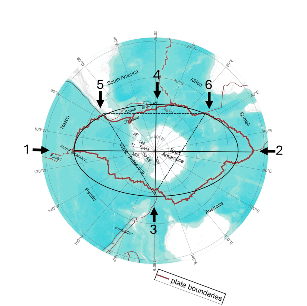
The ellipse looks convincing, main exception is the part from 1 to 3 with a part missing, and longer distance to point 2. The triangle is roughly equal on each side, adding to the harmony of the overall picture.
Here is a table according to measured values referring to the six points of the elliptical form:
| No. | Geological reference | Approximate location | Relationship to ellipse |
|---|---|---|---|
| 1 | Juan Fernández junction region | 35°S, 109–110°W | Near Pacific major-axis direction |
| 2 | Rodrigues Triple Junction | 25.5°S, 70°E | Major-axis direction, beyond theoretical endpoint |
| 3 | Macquarie Triple Junction | 61.5°S, 161°E | Near minor-axis endpoint |
| 4 | Mathematical point between South Sandwich and Bouvet | 60°S, 19°37.5′W | Exact mathematical minor-axis endpoint |
| 5 | Chile Triple Junction | About 46.2°S, 75.8°W | Close to elliptical boundary |
| 6 | African–Antarctic junction region, near Andrew Bain | Approximately 47–53°S, 27–33°E | Complex boundary region intersected by ellipse |
Point 1 — Juan Fernández
The Juan Fernández junction region is associated with the southern termination of the East Pacific Rise near 35°S.
Here, the Pacific, Nazca, and Antarctic plate-boundary systems interact in a region complicated by the Juan Fernández microplate. The junction is particularly important because it establishes the Pacific direction of the major axis. The corresponding theoretical endpoint of the ellipse lies at 30°S, 109°37.5′W. The geological junction is therefore approximately 5° closer to the South Pole than the symmetrical mathematical endpoint.
Point 2 — Rodrigues Triple Junction
The Rodrigues Triple Junction lies near 25°30′S, 70°E, where the Central Indian, Southwest Indian, and Southeast Indian ridges converge. Its longitude is almost exactly opposite that of the Juan Fernández junction, giving the two locations an approximate alignment through the South Pole.
Unlike Point 1, Rodrigues lies farther from the South Pole than the theoretical major-axis endpoint. The angular distances of the two reference points from the pole are approximately 55° and 64.5°, respectively. Their average is close to 60°. The model therefore uses a regularised semimajor axis of 60°, recognising that the two geological reference locations are not equally distant from the pole.
Point 3 — Macquarie Triple Junction
The Macquarie Triple Junction lies near 61°30′S, 161°E, south of New Zealand.
The junction involves the Antarctic, Pacific, and Macquarie plate-boundary systems, including the southern continuation of the Australian–Pacific boundary. The theoretical minor-axis endpoint is situated at 60°S, 160°22.5′E. The geographical separation between the observed reference and theoretical endpoint is approximately 171 km. This is one of the clearest individual geographical correspondences in the model.
Point 4 — The mathematical Atlantic reference point
Point 4 is defined at: 60°S, 19°37.5′W.
Unlike the other reference points, it is not a geological triple junction. Two independently identified geological features lie on opposite sides of its longitude. To the west is the southern termination of the South Sandwich subduction system, where the South Sandwich Trench interacts with transform boundaries involving Antarctica and the South American Plate.
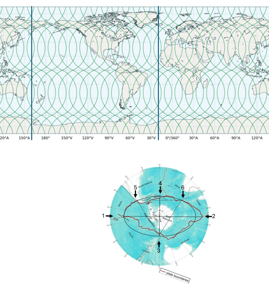
Convection rolls system shown with green lines.
Farther east lies the Bouvet Triple Junction, near 54°50′S, 0°40′W, where the African, South American, and Antarctic plate boundaries meet. The South Sandwich Fracture Zone extends approximately between 24°W and 17.5°W and passes particularly close to the theoretical Point 4.
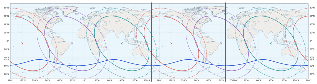
and the two lines extending from minor axis shown.
The representative geographical position of this fracture zone is only about 93 km from Point 4. The Bouvet Triple Junction is approximately 1,270 km away. These two structures are not equidistant from Point 4, and the mathematical point must not be described as their midpoint. Its importance is twofold. It provides the Atlantic endpoint of the minor axis, and its longitude connects the Antarctic geometrical construction with Iceland.
Point 5 — Chile Triple Junction
Point 5 is the intersection of the Nazca, Antarctic, and South American plates near the Taitao Peninsula of southern Chile. At this location, the Chile Ridge reaches the Chile Trench and is subducted beneath South America.
The junction forms the northern termination of the Antarctic–South American convergent plate-boundary sector along southern Chile. In the geometrical model, the junction lies near 46.2°S, 75.8°W. The theoretical ellipse at this longitude reaches approximately 46.81°S. The resulting difference is approximately 66 km in the radial direction of the south-polar projection.
Point 5 is therefore an important independent test location, since it was not used to establish the ellipse’s principal dimensions.
Point 6 — The African deformation system and the Southwest Indian Ridge
Point 6 concerns the continuation of the East African plate-boundary system into the southwestern Indian Ocean. The African continent is divided tectonically into the Nubian and Somalian plates, with the East African Rift marking their divergence across much of eastern Africa. Farther south, their boundary becomes increasingly diffuse.
Plate-motion studies show that the deformation system continues toward the Southwest Indian Ridge, which separates African lithosphere from the Antarctic Plate. Horner-Johnson and colleagues (2005) found that, under the assumption of a narrow boundary between Nubia and Somalia, its intersection with the Southwest Indian Ridge would lie between approximately 26.3°E and 32.9°E. Later plate-kinematic studies introduced the Lwandle Plate, making the boundary configuration more complicated than a simple three-plate intersection.
The Andrew Bain Transform Fault Complex is a prominent geological structure in this region. The theoretical Antarctic ellipse intersects a straight-line approximation of the Andrew Bain system near 50°S, 30°E. This intersection is mathematically defined. It should not be regarded as the precise location of a proven geological triple junction. Nevertheless, the relationship is sufficiently close to warrant detailed comparison with modern digital plate-boundary data.
4. The relationship between Points 4, 5, and 6
Points 5 and 6 are located on opposite sides of Point 4. Using the theoretical position of Point 4 at 60°S, 19°37.5′W:
Moreover, the initial geographical bearings from Point 4 toward the Chile Triple Junction and the northeastern Andrew Bain intersection differ by approximately 176.6°, close to opposite directions.
This is potentially an important additional geometrical relationship.
However, the result depends on how Point 6 is defined. Its geological position is less certain than that of Point 5, and the comparison should not be interpreted as an established equal-distance relationship, except that when drawing is compared with the map base it appears that the triple point fits very well on the ellipse.
5. The Icelandic meridian: 19°37.5′W
The Atlantic endpoint of the Antarctic minor axis lies on the meridian 19°37.5′W.
This meridian passes through Iceland and is also used to define the north–south minor axes of two proposed Icelandic ellipses.
The first is the Icelandic shelf ellipse, centred near 65.54°N, 19°37.5′W, with an east–west major axis of approximately 747 km and a north–south minor axis of 498 km. Its ratio in physical distances is approximately 3:2. The second is the proposed Eyjafjallajökull ellipse, centred at 63°37.5′N, 19°37.5′W. This smaller ellipse has a major axis of approximately 34 km and a minor axis of 17 km, giving a ratio of 2:1. The Antarctic ellipse also has a 2:1 ratio, although its dimensions are defined in a polar map projection. The Icelandic and Antarctic structures therefore share a geographical orientation, while their proposed elliptical dimensions belong to different scales and coordinate systems.
6. Continuation through the North Pole to Kamchatka
One of the most interesting geographical properties of the minor axis is its continuation across the entire globe. The meridian 19°37.5′W and its opposite meridian, 160°22.5′E, belong to the same great-circle plane. Following this plane northward from the Antarctic Atlantic sector, it crosses Iceland and continues across the Arctic Ocean to the North Pole. Beyond the North Pole it follows the 160°22.5′E meridian toward northeastern Asia and Kamchatka.
This is the same longitude direction that defines the opposite minor-axis endpoint of the Antarctic ellipse, near the Macquarie Triple Junction south of New Zealand. The geographical relationship can therefore be expressed as:
South Sandwich sector — Iceland — North Pole — Kamchatka — Macquarie sector — South Pole.
The precise sequence depends on which direction around the great circle is followed, but all these sectors lie on or close to the same meridian pair. Kamchatka provides a particularly interesting geographical comparison. For example, Klyuchevskoy volcano is situated near 56.056°N, 160.642°E, only about 0.267° of longitude east of the theoretical meridian. Thus, the minor-axis direction associated with the Macquarie Triple Junction also passes very close to a major volcanic centre in Kamchatka.
7. The Arctic Ocean and a possible northern polar ellipse
The Arctic Ocean provides an additional opportunity to examine the geometry. The central Arctic seafloor contains several extensive ridge and basin systems, including the Lomonosov Ridge, Gakkel Ridge, Nansen Basin, and Amundsen Basin, the latter also historically known as the Fram Basin. These structures divide the Arctic Ocean into distinct geological and bathymetric regions.
In a polar projection, the Eurasian Basin and its associated ridges exhibit a pronounced elongated geometry. It is therefore reasonable to examine whether an elliptical description of the Arctic Ocean floor could be constructed with an orientation comparable to that proposed for Antarctica. In particular, the 19°37.5′W–160°22.5′E great-circle plane provides a specific reference direction against which the Arctic bathymetric structures can be tested. The comparison does not imply that the Gakkel Ridge, Fram Basin, or Lomonosov Ridge follow this meridian exactly.
Their actual geometries are curved and reflect different geological histories. The Arctic Ocean is also divided among multiple tectonic plates rather than being the equivalent of a single Antarctic Plate. Nevertheless, the similarities in broad orientation merit quantitative examination. An independently fitted Arctic ellipse would allow the apparent correspondence to be assessed without imposing the Antarctic dimensions or orientation in advance.
8. The 90° relationship with Yellowstone
Another geometrical relationship emerges when the Icelandic meridian is compared with Yellowstone. The longitude 19°37.5′W is perpendicular, in polar angular terms, to the meridian 109°37.5′W. Yellowstone is situated near 110.67°W. Its longitude therefore differs from the theoretical perpendicular meridian by only approximately 1.05°. This places Yellowstone close to the 90° longitudinal direction relative to Iceland and the Antarctic minor-axis meridian.
The observation is independent of the relative latitudes of Iceland and Yellowstone and does not establish a mechanical connection between their geothermal systems. However, it provides another well-defined geographical relationship that can be examined within the proposed global convection-roll framework.
9. East and West Antarctica and the minor-axis direction
The division between East and West Antarctica provides a further geographical comparison. East Antarctica is primarily an ancient continental shield, whereas West Antarctica consists of several tectonically complex crustal provinces with a history of extension, volcanism, and sedimentary basin development. The Transantarctic Mountains broadly separate these two geological regions, extending between the Ross and Weddell Sea sectors. The proposed minor axis of the Antarctic ellipse also connects the Ross Sea direction with the Atlantic and Weddell Sea sectors.
This regional correspondence is important, although the mountain belt and the geological division between East and West Antarctica do not coincide with the mathematical minor axis along their entire lengths. The relationship should therefore be understood as one of broad orientation rather than an exact geographical boundary.
10. Discussion and conclusions
The proposed Antarctic ellipse is defined by a 2:1 axis ratio in a south-polar azimuthal equidistant projection, centred on the geographical South Pole. Six tectonic reference locations provide a framework for testing its geometrical relationships. The Juan Fernández and Rodrigues junctions establish a nearly straight major-axis direction passing close to the South Pole. Rodrigues lies farther from the pole than the corresponding theoretical endpoint, whereas Juan Fernández lies closer to it. The Macquarie Triple Junction lies close to one of the theoretical minor-axis endpoints.
Point 4 is unique because it is not a geological triple junction. Rather, it is a mathematical reference point situated between the South Sandwich subduction system and the Bouvet Triple Junction. Its proximity to the South Sandwich Fracture Zone and its shared longitude with Iceland make it particularly important. The Chile Triple Junction and the African–Antarctic plate-boundary region provide further tests of the elliptical outline. The geometry also introduces a broader global relationship.
The Antarctic minor-axis meridian passes through Iceland and the North Pole, continuing toward Kamchatka on the opposite side of the globe. The Macquarie Triple Junction lies close to the same meridian in the Southern Hemisphere, while Yellowstone is approximately 90° away in longitude. The proposed Icelandic shelf and Eyjafjallajökull ellipses provide additional geometrical comparisons at smaller geographical scales.
Finally, the elongated bathymetric systems of the Arctic Ocean suggest that a similar polar geometrical analysis may be useful in the Northern Hemisphere. The central hypothesis is that these regional and global alignments may express aspects of a common geometrical organisation of tectonic activity. Establishing whether this organisation has a physical origin will require quantitative comparisons with independent plate-boundary, bathymetric, geodetic, and mantle-imaging data. The ellipse should therefore be regarded as a testable geometrical model, rather than a demonstrated description of the forces controlling global plate tectonics.
Selected scientific references
- Juan Fernández microplate and the Pacific–Nazca–Antarctic junction (1987)
- Rodrigues Triple Junction — IUGS
- The Indian–Antarctic–Pacific Triple Junction — Falconer (1972)
- South Sandwich Fracture Zone — SCAR Gazetteer
- The Bouvet Triple Junction — Phillips and Tapscott (1976)
- Nubia–Somalia–Antarctica Triple Junction — Horner-Johnson et al. (2005)
- Lwandle Plate along the Southwest Indian Ridge (2007)
- Morphology and Structure of the Lomonosov Ridge (2006)
- Antarctic Geology — Australian Antarctic Program


