
According to the tectonic-ring model associated with the mantle convection-roll system, the Red Sea and the Gulf of California occupy remarkably similar geometrical positions.
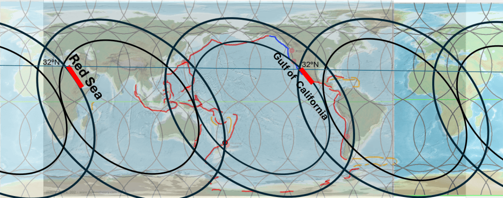
and the other theoretical tectonic rings of the Atlantic and Indian oceans.
Both form elongated zones of crustal extension situated along the margins of large tectonic rings, although they occur on opposite sides of the global system.
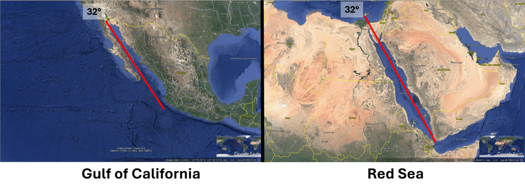
The Red Sea
In the model, the Red Sea is situated along the outer periphery of the Atlantic tectonic ring, which is theoretically derived as the counterpart of the Pacific Ring of Fire. Its elongated form follows the curvature of the corresponding elliptical boundary.
On the map, 32°N latitude is shown as a reference line and marks the northern limit of the section highlighted in red. From there, the tectonically active zone extends southward toward the Afar region, where the Red Sea system connects with the Gulf of Aden and the East African Rift.
The Gulf of California
The Gulf of California occupies a comparable position along the inner periphery of the Pacific tectonic ring, or Ring of Fire. As in the Red Sea, the elongated tectonic zone approximately follows the geometry of the relevant elliptical boundary.
Again, 32°N latitude is shown as a reference, allowing the geographical positions of the two systems to be compared directly. The Gulf of California extends southward from approximately this latitude and forms part of the active boundary between the Pacific and North American plates.
A striking geometrical comparison
Comparison of the two regions reveals several noteworthy similarities:
- Both form long, narrow tectonic basins produced by crustal extension.
- Both are associated with active plate separation and magmatism.
- Both occupy marginal positions within the proposed tectonic-ring geometry. The Red Sea follows the outer boundary of the Atlantic ring, whereas the Gulf of California follows the inner boundary of the Pacific ring.
- The highlighted sections occupy broadly comparable latitude ranges and can therefore be compared directly using the 32°N reference line.
- Both systems developed mainly during the Cenozoic and underwent major tectonic reorganization during the Miocene and later.
- In both cases, extension is not expressed as a single simple fracture. Instead, deformation is distributed through rift basins, faults, volcanic zones, and, in more developed sections, spreading centres.
The similarity is particularly interesting because the two systems belong to different conventional plate-tectonic settings. The Red Sea records the separation of Arabia from Africa, whereas the Gulf of California forms part of the Pacific–North America plate boundary. Nevertheless, when viewed within the tectonic-ring framework, both occupy equivalent geometrical positions along major elliptical boundaries. The precondition of this comparison is of course at first to analyse the form of the Ring of Fire, and the to transfer that analysis to the Atlantic Ocean.
Possible significance
The comparison therefore raises an important question: can the similar geometry of the Red Sea and the Gulf of California be explained solely by their individual plate-tectonic histories, or does their position within a larger global geometrical system also play a role?
Within the convection-roll model, the resemblance is not regarded as accidental. The two regions can be interpreted as corresponding expressions of extension along the boundaries of two different tectonic rings: one on the outer side of the Atlantic ring and the other on the inner side of the Pacific ring.
Their similar elongated forms, broadly comparable latitudinal positions, young geological development, and relationship to active extension make the Red Sea–Gulf of California comparison a useful test case for examining the proposed connection between mantle convection rolls and the large-scale geometry of plate boundaries.


