
The Philippine Sea Plate is one of the smaller major tectonic plates of the Earth. It is surrounded by a complex system of plate boundaries and microplates, but in broad terms it occupies the region between the Eurasian Plate to the west, the Pacific Plate to the east, and the Australian Plate to the south.
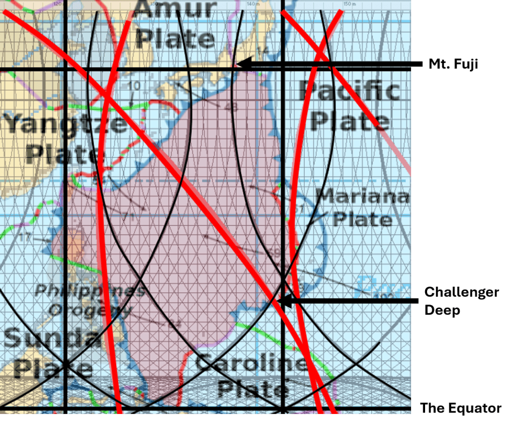
When the geometry of the Pacific Ring of Fire is analysed within the convection-roll model, an additional spatial framework emerges. The tectonically active margins surrounding the Pacific appear, in this model, to be largely confined within zones corresponding to the influence of convection-roll systems 15° wide on either side of the Pacific basin, of approxiamately 19.5°.
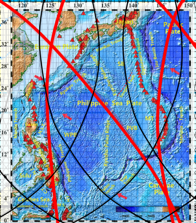
This produces a regular geometrical framework defined by elliptical forms. The principal Pacific ellipse is centred at approximately 6°S, 150.7°E and is rotated by about 45° when plotted on an equidistant rectangular map. Its geometry is related to a larger elliptical system extending toward the South Pole. Two corresponding elliptical systems can then be positioned at intervals of 120° in longitude, producing three major tectonic-ring frameworks around the Earth.
The geometry is constrained by fixed parameters. In the coordinate system used here, the inner ellipse has a minor semiaxis of 51.8 units and a major semiaxis of 77.7 units, whereas the outer ellipse has corresponding values of 71.0 and 96.5 units. Once these parameters, centres, and orientations have been fixed independently, the resulting framework can be compared with observed geological structures without further adjustment.
The Philippine Sea Plate at the Intersection of Two Tectonic Rings
One particularly interesting comparison concerns the Philippine Sea Plate. Within this geometrical framework, the plate occupies the intersection between the Pacific tectonic ring (the Ring of Fire) and the neighbouring tectonic ring associated with the Indian Ocean.
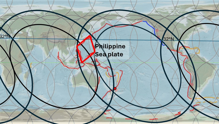
The Philippine Sea Plate fits remarkably regularly within this intersection zone. In simplified geometrical form, it can be represented as a diamond-shaped region whose southern apex approaches the Equator. Its eastern and western margins broadly follow the structural directions generated by the intersecting ring systems, while its northern termination lies within the complex tectonic region of Japan.
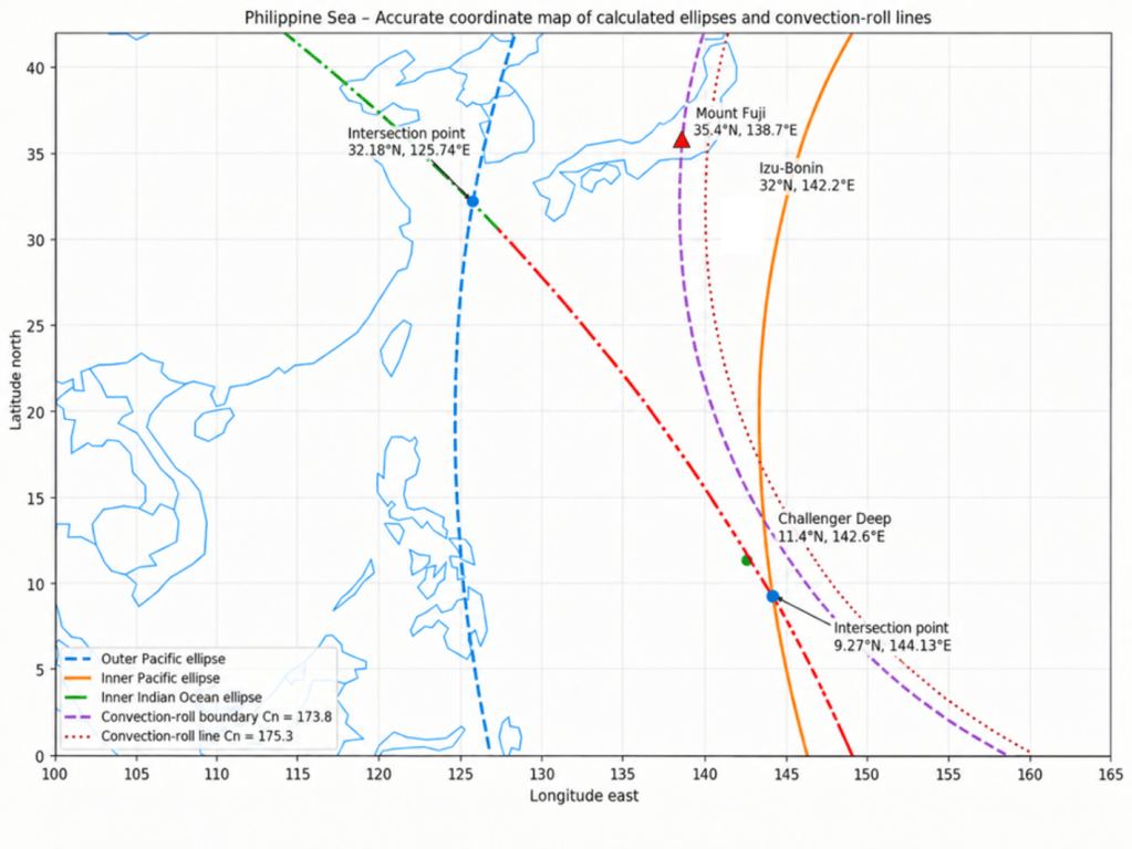
Several individual features provide useful reference points for testing the geometry. The inner margin of the Indian Ocean tectonic ring reaches the Mariana–Philippine Sea boundary close to the Challenger Deep, the deepest known point in the world’s oceans. This is situated along the boundary between the Philippine Sea Plate and the Pacific Plate. Farther north, Mount Fuji lies close to one of the principal convection-division lines defined by the model.
The geometry also highlights the possible structural significance of particular latitudes. The Equator forms an important southern reference line, while approximately 32°N provides a northern geometrical boundary within the model. Much of the Philippine Sea Plate is therefore contained between these two latitude controls.
A second regularity appears in longitude. North–south axes can be defined at intervals related to the 15° convection-roll spacing, together with an additional half-spacing of 7.5°. This gives a characteristic east–west interval of approximately 22.5°, comparable with the longitudinal width of the plate and its surrounding tectonic system.
A Geometrically Constrained Plate
The significance of the Philippine Sea Plate in this analysis is therefore not based on a single point of correspondence. Several independent geometrical elements can be compared simultaneously: the Equator, the 32°N latitude, the north–south convection divisions, the margins of the two intersecting tectonic rings, the position of the Mariana Trench and Challenger Deep, and the northern tectonic junction near Japan.
Taken together, these relationships make the Philippine Sea Plate a particularly useful area for testing the tectonic-ring model. Instead of appearing as an irregular plate whose shape is considered only in relation to its immediate neighbouring plates, it can be examined as a structure occupying a geometrically defined intersection between two larger-scale tectonic systems.
The most striking feature is therefore the overall confinement of the Philippine Sea Plate within the overlapping domains of the Pacific and Indian Ocean tectonic rings. If this correspondence remains consistent when tested against independently mapped plate boundaries, trenches, volcanic arcs, and seismic zones, the Philippine Sea region may provide one of the clearest examples for evaluating the proposed global convection-roll framework.
Further reading: https://pangea.stanford.edu/ERE/db/GeoConf/papers/SGW/2024/Thorbjarnarson.pdf
Challenger Deep: A Convergence of Geometrical and Tectonic Features
A particularly significant location within this framework is the Challenger Deep, because several of the geometrical relationships investigated in this study converge within a very small area. Challenger Deep is located near 11°22′N, 142°30′E, at the southern end of the Mariana Trench. Modern measurements place its greatest depth at approximately 10,935 ± 6 m below mean sea level, making it the deepest reliably measured point in the world’s oceans.
In conventional plate-tectonic terms, Challenger Deep forms part of the Izu–Bonin–Mariana subduction system. Along this system, the Pacific Plate descends westward beneath the plate system forming the eastern margin of the Philippine Sea region. At the southern Mariana Trench, the immediate overriding plate is the Mariana microplate, separated farther west from the main Philippine Sea Plate by the Mariana Trough. Thus, Challenger Deep occupies a highly distinctive position along the eastern tectonic boundary of the broader Philippine Sea Plate system.
Within the convection-roll and tectonic-ring model presented here, however, the location acquires an additional geometrical significance.
The eastward-bending convection roll centred at approximately 113.8°E, with its geometry referenced to 32°N and a radius of 35.341 model units, intersects the inner elliptical margin of the Indian Ocean tectonic ring almost exactly in the Challenger Deep region. The Indian Ocean ring is defined here by a centre at approximately 90.7°E, 6°S, with an inner ellipse having semiaxes of 51.8 and 77.7 model units and an orientation of approximately 45° NW–SE.
Because these geometrical parameters are established independently of the position of Challenger Deep, the correspondence provides a useful test of the proposed framework rather than a geometrical construction fitted specifically to the trench.
A second convection-roll structure also approaches this location. The westward-bending roll centred at approximately 173.8°E, which passes beneath the Fuji region farther north, intersects the 113.8°E roll system only about 2° of map distance from Challenger Deep. The proximity of this lower-mantle roll intersection to the deepest part of the Mariana Trench is therefore another feature that can be tested against the model.
These roll intersections are also associated in the model with major north–south structural axes. Comparable axes can be traced northward from Antarctica, and one of these axes closely follows the eastern side of the Philippine Sea Plate system. Challenger Deep consequently lies close not only to a plate boundary and an elliptical ring margin, but also to one of the principal N–S divisions generated by the convection-roll geometry.
A fourth geometrical element occurs immediately to the east. The inner margin of the Pacific tectonic ring (the Ring of Fire) lies only about 3° east of Challenger Deep. Southeast of the Challenger Deep region, this Pacific-ring margin approaches and eventually intersects the inner margin of the Indian Ocean tectonic ring. Challenger Deep is therefore situated close to the area where the influence zones of two independently defined tectonic rings converge.
The location can consequently be described in terms of several superimposed geometrical controls:
- the active Pacific–Mariana subduction boundary;
- the inner margin of the Indian Ocean tectonic ring;
- the nearby inner margin of the Pacific Ring of Fire;
- the intersection of two convection-roll systems;
- and a major N–S structural axis associated with the convection-roll framework.
The morphology of Challenger Deep itself may also be relevant. Rather than forming one simple linear depression, its deepest region consists of several elongated depressions arranged in a broadly right-stepping en echelon pattern. Such segmentation suggests that the morphology of the trench cannot necessarily be described solely in terms of motion perpendicular to the subduction boundary. Along-strike deformation, oblique stresses, inherited structures, and deformation within the overriding and subducting plates may also contribute to its detailed form.
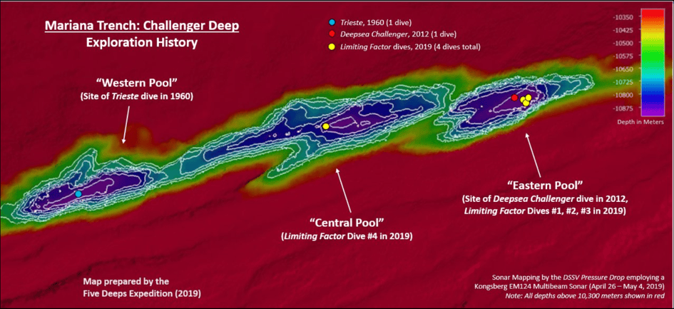
Within the model proposed here, this geometry raises an additional possibility. The Mariana subduction system represents the dominant conventional tectonic process operating at the site, while the elliptical tectonic-ring boundaries describe predominantly horizontal, large-scale geometrical controls. The convection-roll divisions, in contrast, represent vertically organised mantle circulation expressed at the surface through their predicted boundaries and intersection zones.
Challenger Deep may therefore represent an especially useful location for examining the proposed interaction between these two components: horizontal tectonic organisation associated with the elliptical ring system and vertically organised mantle circulation associated with the convection rolls. Their spatial coincidence with an active subduction zone could help explain why this particular part of the plate boundary has developed such an exceptional and strongly segmented morphology.
This does not by itself demonstrate a causal relationship between the geometrical framework and the exceptional depth of Challenger Deep. It does, however, provide a particularly well-constrained location at which several independently derived elements of the model can be compared directly with observed bathymetry, plate boundaries, seismicity, and subduction geometry.
According to the present model, Challenger Deep is located at a point where two independently defined structural controls coincide. The inner margin of the tectonic ellipse passes through the area, while a convection-roll division derived from a different part of the model also intersects the same locality. Their orientations are therefore not merely spatially close; they form a superimposed geometrical framework at the site.
This suggests that several tectonic components may be acting together. The Mariana subduction system provides the dominant convergent setting, while the regional oblique plate motion introduces a significant strike-slip component. Superimposed on this, the model places both an elliptical tectonic boundary and a convection-roll division through the Challenger Deep region. The morphology of the deep may therefore reflect the combined influence of convergence, lateral shear, and the interaction of these two larger-scale structural controls.
In this interpretation, Challenger Deep becomes especially significant because the different elements are derived independently. The elliptical geometry is defined by the tectonic-ring framework, whereas the convection-roll directions are determined by the mantle-roll system. Their intersection at the same location, together with the observed trench and strike-slip geometry, provides a particularly useful site for testing whether these proposed controls are reflected in the actual structure of the plate boundary.


