
When the distribution of earthquake epicentres in Iceland during the period 1994–2007 is compared with the surface pattern predicted by the convection-roll model, a considerable degree of spatial correspondence becomes apparent.
The relationship takes somewhat different forms in different parts of the country. Across southern Iceland, much of the seismicity is concentrated within, along the margins of, or near the corners of the diamond-shaped sectors formed by the division lines of the model. North of Iceland, the pattern is different: within the Tjörnes Fracture Zone, earthquake epicentres tend to form elongated belts that can be compared directly with individual division lines.
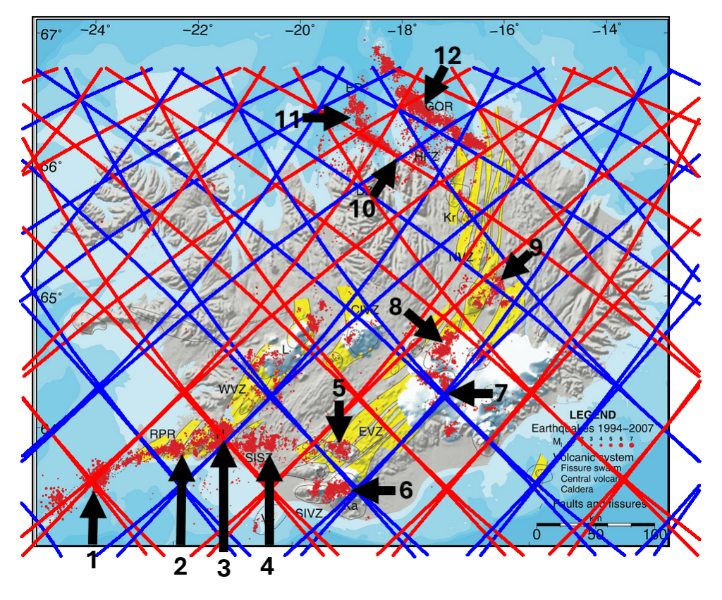
Several examples illustrate this relationship particularly clearly.
1. The Reykjanes Ridge and the Njörður area
At this location, the Reykjanes Ridge, as an oceanic spreading ridge, meets an offshore structural system transverse to the ridge. A marked concentration of earthquake epicentres occurs close to this intersection.
The area is also associated with Njörður, a large submarine central volcano situated on the Reykjanes Ridge. Within the convection-roll framework, the concentration of tectonic and volcanic activity near this location is significant because it occurs close to an intersection between major division lines.
2. The curved seismic belt of the Reykjanes Peninsula
The earthquake belt extending across the Reykjanes Peninsula does not form a simple straight continuation of the Reykjanes Ridge. Instead, it bends progressively eastward toward the Hengill–Hveragerði region.
Within the convection-roll model, this geometry can be interpreted as a connection between the offshore Reykjanes Ridge and the Western Volcanic Zone. The two principal connection points are not located at the same latitude, and the complete seismic system consequently extends across two adjoining diamond-shaped sectors.
Of particular interest is that the curvature of the seismic belt from the Njörður area toward Hveragerði can be represented by the same mathematical arc used to construct the corresponding division line in the model.
3. Hveragerði and the Hengill region
The Hveragerði–Hengill region is one of the most seismically active areas of southwestern Iceland.
In the convection-roll model, this is not merely a minor intersection between division lines. It represents a principal intersection associated with the lower-mantle framework, where division systems derived from the polar and equatorial geometries converge.
The model therefore places an unusually important structural intersection close to Hveragerði and Reykjafell. The high concentration of earthquake epicentres in this area is consequently one of the more conspicuous spatial correspondences between the calculated geometry and observed seismicity.
4. The South Iceland Seismic Zone
The South Iceland Seismic Zone provides another particularly clear example. Earthquake epicentres are concentrated in a broadly east–west belt extending between the western and eastern corners of one of the model’s diamond-shaped sectors. The main trend extends approximately from the Hveragerði region toward Hekla, close to 64°N.
Thus, rather than following only a single division line, the seismicity occupies the interior of a geometrically defined sector and is particularly concentrated between its opposing corners.
5. Torfajökull
East of the main South Iceland Seismic Zone lies the Torfajökull volcanic system. This area can be regarded both as a distinct volcanic and geothermal region and, in geometrical terms, as an eastward continuation of the structural pattern associated with the South Iceland Seismic Zone. The concentration of earthquake epicentres around Torfajökull again occurs within a sector defined by the division-line geometry.
6. Eyjafjallajökull and Mýrdalsjökull
Farther south, earthquake clusters coincide with the volcanic systems of Eyjafjallajökull and Mýrdalsjökull, including the Katla caldera beneath Mýrdalsjökull. An additional feature is the approximately east–west arrangement of seismicity across the central part of the corresponding diamond-shaped sector. The relationship therefore involves both the location of the volcanic centres and the internal geometry of the sector itself.
7. Grímsvötn
The Grímsvötn area beneath Vatnajökull is one of Iceland’s most active volcanic regions. On the earthquake map, much of the seismicity in this region falls within the same diamond-shaped sector predicted by the convection-roll model. The concentration is therefore not restricted to a single line or intersection; instead, the active region occupies a substantial part of one geometrically defined cell.
8. Bárðarbunga
Bárðarbunga forms another major concentration of volcanic and seismic activity beneath northwestern Vatnajökull. Its caldera and associated fissure system lie within the same broader geometrical framework. The seismicity around Bárðarbunga therefore provides an additional test of whether the division lines and the diamond-shaped sectors have a systematic relationship with the distribution of tectonic and volcanic activity.
9. Askja and the northeast-trending fissure swarm
The Askja region forms a distinct seismic and volcanic centre farther north. From Askja, earthquake activity extends northeastward along the associated fissure swarm. In the convection-roll interpretation, both the location of Askja and the orientation of this northeast-trending seismic zone correspond with the underlying division-line pattern.
This is important because the comparison involves not only the position of an individual volcanic centre but also the direction in which tectonic activity extends away from it.
10. The Húsavík–Flatey Fault
North Iceland provides a different type of comparison. The Húsavík–Flatey Fault (HFF), one of the principal structures of the Tjörnes Fracture Zone, is marked by a pronounced belt of earthquake activity. Within the convection-roll model, this belt follows one of the calculated division-line trends remarkably closely.
Toward the western part of the Tjörnes Fracture Zone, the orientation of the seismicity changes as the system approaches the connection with the Kolbeinsey Ridge. This change occurs close to an area where division lines of the convection-roll framework also intersect and change their geometrical relationship.
The importance of this example is therefore twofold: the earthquake belt follows a predicted division-line direction over a considerable distance, while its change in geometry also occurs close to a significant intersection in the model.
11. The Grímsey Oblique Rift
The Grímsey Oblique Rift (GOR) forms the second major seismic belt of the Tjörnes Fracture Zone. Its orientation corresponds closely to the next division line to the north in the convection-roll framework. The earthquake epicentres do not form an infinitely narrow line, but rather a relatively broad zone extending mainly northward from the calculated boundary.
The width of this seismic zone corresponds approximately to two adjacent convection-roll sectors. A comparable relationship can be observed along the Húsavík–Flatey Fault, suggesting that the influence of the structural boundaries may extend across more than a single line.
Different Forms of Spatial Correspondence
The comparison between the 1994–2007 earthquake distribution and the convection-roll framework is therefore not based on one particular type of geometrical relationship. At least three recurring forms can be distinguished.
First, major concentrations of seismicity occur near intersections of division lines, as seen particularly in the Hveragerði–Hengill region and offshore along the Reykjanes Ridge.
Second, earthquake activity may occupy or follow the internal geometry of diamond-shaped sectors, as seen across southern Iceland from the South Iceland Seismic Zone through the central volcanic regions.
Third, elongated seismic zones may follow individual division lines, as is particularly evident in the Tjörnes Fracture Zone, including the Húsavík–Flatey Fault and the Grímsey Oblique Rift.
The significance of the comparison therefore lies not simply in individual earthquake clusters coinciding with individual calculated lines. Rather, similar geometrical relationships appear repeatedly in different tectonic settings: at volcanic centres, within seismic zones, at major intersections, and along long linear fault and rift systems.
This repeated spatial correspondence provides a basis for testing whether the surface geometry derived from the convection-roll model is related in a systematic way to the distribution of seismic and volcanic activity in Iceland.


