
When discussing the spreading of Iceland and the boundary between the North American and Eurasian plates, three main types of tectonic structures need to be considered: mid-ocean ridges, volcanic zones, and seismic zones. Within the convection-roll model presented here, all three can be related to lines that can be constructed geometrically on a map from the predicted positions of the convection-roll boundaries.
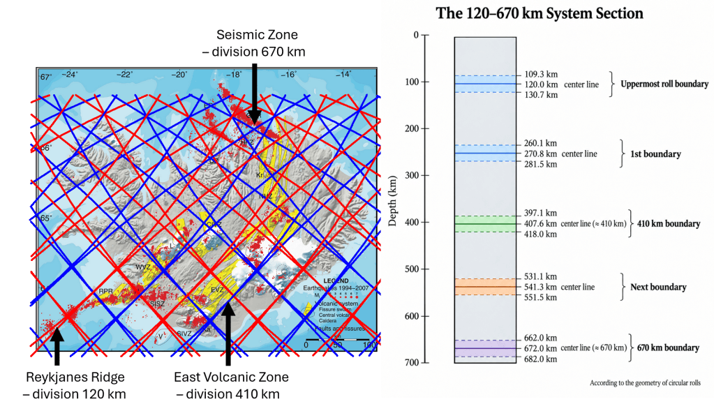
Convection rolls divisions marked with red and blue lines.
The convection-roll system follows a relatively simple mathematical pattern, with each mantle layer represented by its own set of convection rolls and associated division lines. Iceland, however, is more complex than many other regions because it lies where elements of the polar and equatorial convection systems overlap and interact.
The correspondence is particularly clear when the predicted lines are compared with the major tectonic structures of Iceland. In the simplified interpretation used here, the Reykjanes Ridge follows a convection-roll division associated with the approximately 120 km level, the Eastern Volcanic Zone corresponds closely to a line associated with the 410 km level, and the Tjörnes Fracture Zone follows lines related to the approximately 670 km level.
Conditions in southern Iceland are more complicated because division lines belonging to convection rolls at different depths commonly lie very close to one another. In some places they almost coincide and therefore appear on a map as a single tectonic line. A complete description of the boundaries shown on the map is consequently more complex than the simplified depth assignments given above. The 120, 410, and 670 km levels should therefore be regarded here primarily as reference levels for the geometrical system.
When the framework is traced across Iceland, numerous correspondences appear between the calculated lines and mapped geological structures. For example, the blue downwelling lines reproduce the eastern boundaries of both the Eastern Volcanic Zone and the Western Volcanic Zone with notable precision. The geometry of the system also indicates an approximately 3° longitudinal separation between these two volcanic zones.
A comparable relationship can be observed in the Tjörnes Fracture Zone in northern Iceland. There, two principal seismic lineaments correspond closely to adjacent convection-roll lines separated by approximately 1.5°. The fracture zone can therefore be examined not simply as an isolated transform system, but as part of a broader geometrical framework linking the positions of mantle convection-roll boundaries with surface tectonic structures.
As progressively more geological information is incorporated into the comparison, additional relationships can be tested against the predicted convection-roll geometry. This makes Iceland particularly useful as a natural test area, because mid-ocean ridge segments, volcanic zones, fracture zones, seismicity, and individual geological structures can all be compared with the same underlying geometrical framework.

 Magic Magma