
Iceland provides an unusually detailed example of the relationship between surface tectonic structures and the proposed mantle convection-roll division system.
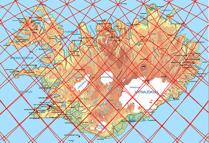
On the scale of the major oceanic plates, the convection-roll geometry can be compared with long plate boundaries, mid-ocean ridges and the elliptical tectonic rings. In Iceland, however, the same framework can be examined at much higher resolution. Volcanic zones, individual volcanic systems, fracture zones and even smaller polygonal structures can be compared directly with calculated mantle-division lines.
Four different types of correspondence are particularly useful.
1. Volcanic zones — the Eastern Volcanic Zone
One of the clearest examples is the Eastern Volcanic Zone of Iceland.
Its general orientation corresponds closely to the calculated direction of the convection-roll system beneath Iceland. Rather than treating the volcanic zone simply as an irregular surface continuation of plate spreading, the convection-roll model provides an underlying geometrical direction against which the zone can be compared.
This is important because the mantle divisions do not everywhere trend directly north–south. Their calculated orientation varies systematically with latitude. Iceland therefore provides a particularly useful test: the direction of the volcanic structures can be compared with a direction calculated independently from the convection-roll geometry.
The Eastern Volcanic Zone represents the first level of correspondence:
In other words, the model can be tested against the orientation of an entire volcanic belt.
2. Intersection points — Hekla
A second type of relationship occurs at intersections between calculated structural lines.
Hekla provides an important example.
Its position is associated not merely with the direction of one convection-roll division, but with a location where different geometrical elements of the system intersect. Such intersection points are potentially more important than individual lines because they represent places where different components of the underlying geometrical framework act together.
This provides a second level of correspondence:
Hekla is therefore useful not simply because it is a major volcano, but because its location can be examined in relation to a predicted geometrical crossing point. This may also help explain why some locations within a volcanic zone become much more prominent than others. A volcanic belt defines a broader structural corridor, while intersections may define particularly favourable locations within that corridor.
3. Polygonal structures, the South Iceland polygon
A third expression of the system appears when the calculated division lines are combined to form polygonal structures. South Iceland provides one of the clearest examples.
Here the relevant convection-roll divisions do not produce only isolated N–S or E–W lines. Their interaction defines a larger geometrical framework within which the tectonic structures of South Iceland can be analysed.
The South Iceland polygon is particularly important because it shows that the model is not restricted to matching the orientation of individual faults or volcanic zones. The intersections and connecting lines form a larger geometrical unit.
The relationship can therefore be written:
Within such a framework, individual fracture zones, volcanic systems and changes in structural orientation can occupy different sides, corners or internal divisions of the polygon.
This is also important for understanding the South Iceland Seismic Zone. The surface deformation need not reproduce the deeper geometrical framework as one continuous fault. Instead, the larger stress field can be accommodated through numerous smaller faults and fracture systems.
Thus, a relatively simple underlying geometry may produce a considerably more complex surface expression.
4. Linear boundaries — the Tjörnes Fracture Zone
The Tjörnes Fracture Zone provides a fourth type of comparison. Here the relationship is expressed through comparatively long tectonic lines and changes in direction that can be compared directly with the calculated convection-roll divisions. This differs from Hekla, where the emphasis is on an intersection, and from South Iceland, where the emphasis is on a polygonal framework.
The Tjörnes system illustrates the more direct relationship:
The fracture zone therefore provides another independent way of testing the model. A calculated mantle division can be compared not only with volcanic structures but also with a major transform and fracture-zone system.
Four expressions of the same underlying geometry
Taken together, these examples are particularly useful because they are not repetitions of the same type of observation. They represent four different geometrical relationships:
- Volcanic-zone alignment — Eastern Volcanic Zone
- Intersection point — Hekla
- Polygonal framework — South Iceland
- Linear tectonic structure — Tjörnes Fracture Zone
The significance of Iceland is therefore not based on one volcanic zone or one particularly favourable line. The same calculated framework appears to correspond to different types of geological structures at different scales.
The sequence can be summarized as:
This is one reason why Iceland has been so important in the development of the convection-roll model. The geological structures are sufficiently detailed to allow relationships to be examined on a much smaller scale than is possible around most major oceanic plates.
From Iceland to the global system
Iceland can therefore be regarded as a high-resolution calibration area for the larger geometrical framework. The same principles that can be examined locally in Iceland—directional divisions, intersections, polygonal structures and transitions between structural lines—can subsequently be investigated on the scale of entire tectonic plates.
This creates an important connection between the Icelandic examples and the analyses of the African, Somali and Nazca plates: In Iceland, the convection-roll framework can be examined at high resolution through volcanic zones, intersection points, polygons and fracture zones. On the scale of the major plates, the same geometrical principles appear as long plate boundaries and their interaction with the larger tectonic-ring system.


