
When considering the spreading of Iceland and the boundary between the North American and Eurasian plates, three main types of tectonic boundaries or structures need to be taken into account. These are, first, mid-ocean ridges; second, volcanic zones; and third, seismic zones. Within the convection-roll model, all of these follow lines that can be constructed on a map on the basis of the geometrical analysis of the convection rolls.
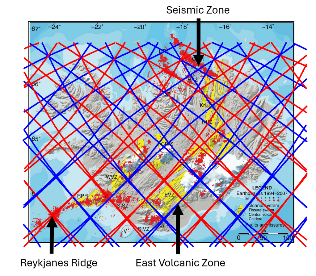
The convection-roll system follows a simple mathematical pattern, with each depth layer having its own set of convection rolls. In Iceland, however, the situation is more complex than in many other regions because the convection rolls of the polar system and the equatorial system meet and interact there. The correspondence is clearly visible on the map. The Reykjanes Ridge, for example, follows convection-roll divisions associated with the 120 km level over a considerable distance.
In southern Iceland, the situation is further complicated by the fact that division lines belonging to convection rolls at different depths often lie very close to one another, so that they may appear almost as a single line. A precise description of the boundaries shown on the map is therefore considerably more complex than the simplified interpretation presented here. The depth levels are used primarily as convenient reference levels.
As can be seen, the comparison can be extended across the whole of Iceland, revealing correspondences between the calculated lines and geological structures. Blue downwelling lines reproduce the eastern boundaries of both the Eastern Volcanic Zone and the Western Volcanic Zone with considerable precision. The geometry also shows that the two volcanic zones are separated by approximately 3°.
A similar relationship occurs in the Tjörnes Fracture Zone in northern Iceland. There, two principal seismic source lines correspond to adjacent convection-roll division lines separated by 1.5°. As more geological information is incorporated into the comparison, an increasing number of features can be tested against, and found to correspond with, this convection-roll framework.
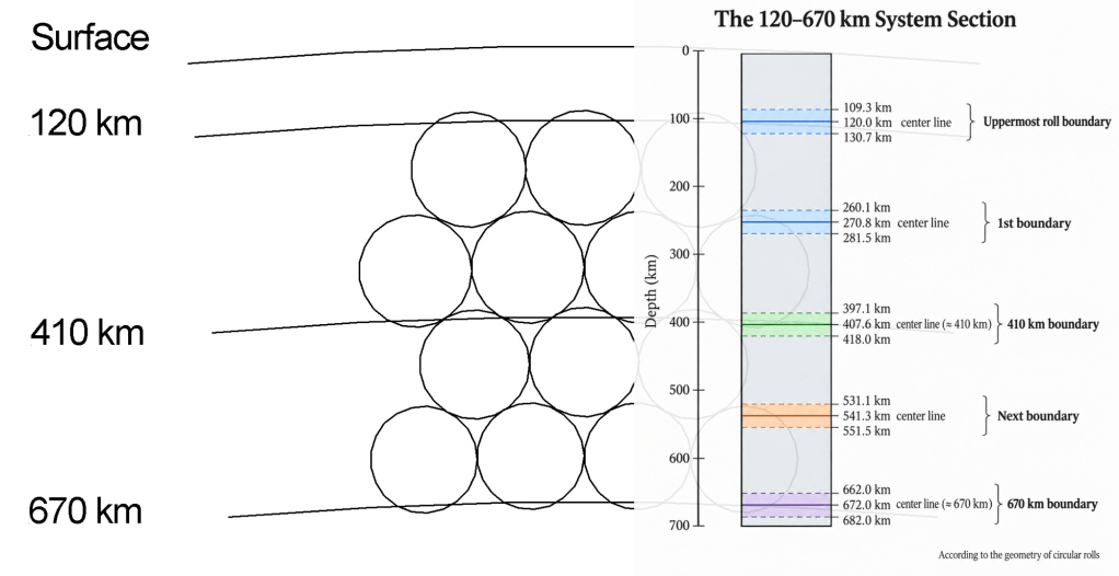
To compare these lines with the 120–670 km System Section, each mapped line can be related to the boundary of a particular depth interval. The section illustrated here applies to regions south of 60.7°N and also north of 67.3°N. Within the intervening latitude range, the geometry is considerably more complex: the number of layers effectively doubles, while their thicknesses vary with latitude. Nevertheless, the basic division is retained, and each layer can still be followed mathematically, allowing the boundaries of the convection rolls to be constructed with precision.
The polar system takes over progressively from the equatorial system and is superimposed upon it. At 64°N, however, the two systems act in combination, and the convection rolls of the two systems are aligned directly above one another. North and south of this latitude, the corresponding rolls gradually diverge from one another. Farther north, the polar system becomes increasingly dominant.
It is particularly noteworthy that the principal seismic zones—the Tjörnes Fracture Zone and the South Iceland Seismic Zone—are associated with different convection-roll division lines from those followed by the Reykjanes Ridge and the volcanic zones. These seismic-zone divisions are related to deeper parts of the system, specifically to the convection rolls immediately above the 410 km boundary. The same geometrical pattern is then repeated between the 410 km and 670 km depth levels.


