
Iceland Seismic Zone — A Geometric Link Between Iceland’s Rift Systems
The South Iceland Seismic Zone is one of the most remarkable tectonic regions in Iceland. It is not only a zone of frequent earthquakes, but also a key to understanding how stress, volcanic systems, and crustal deformation interact across the island. While the volcanic zones of Iceland often receive most public attention, the seismic zone between them reveals an equally important part of the tectonic structure.
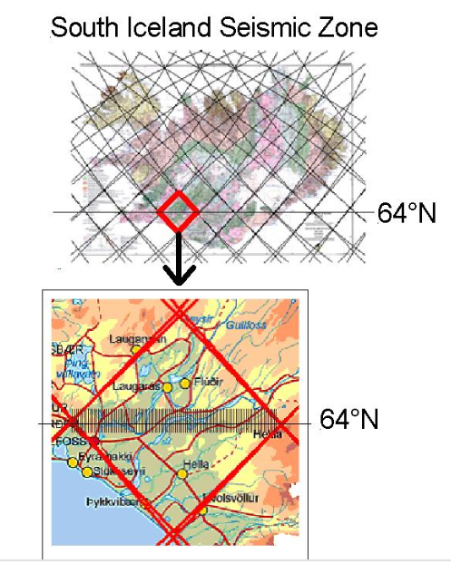
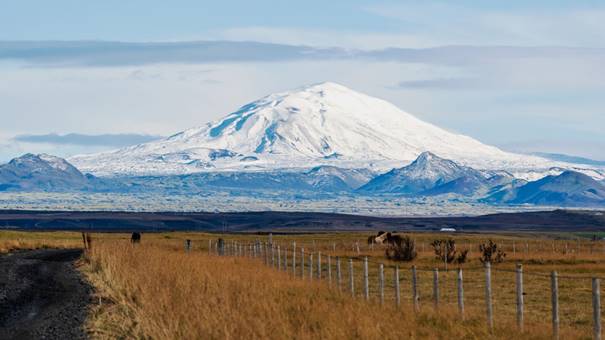
framing the South Iceland Seismic Zone.
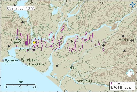
The zone stretches across southern Iceland, roughly between the western volcanic systems near Hengill and the eastern systems connected with Hekla and the East Volcanic Zone.
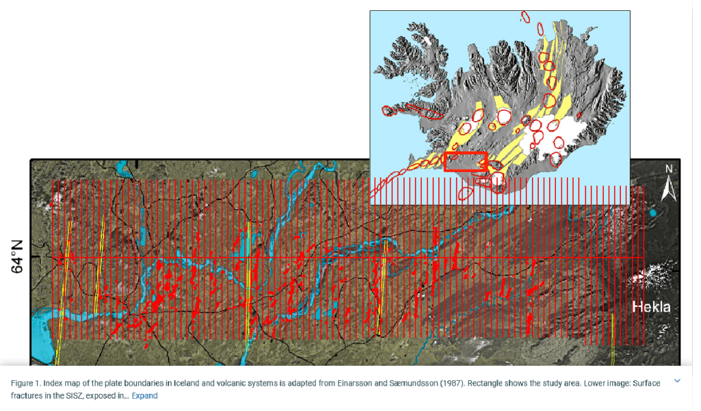
superimposed on a map of the South Iceland Seismic Zone.
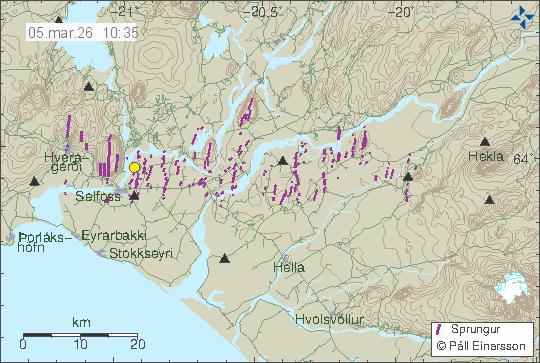
Unlike the volcanic rift zones, where extension is expressed through volcanism and fissure swarms, the South Iceland Seismic Zone mainly releases tectonic stress through earthquakes.
A Transform Zone Across Iceland
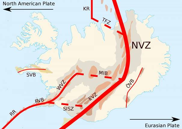
In plate tectonics, Iceland is usually described as a place where the Mid-Atlantic Ridge rises above sea level. The North American and Eurasian tectonic plates move apart across the island. However, the spreading is not expressed as one single continuous rift. Instead, the volcanic zones are offset from each other.
The South Iceland Seismic Zone acts as a transfer structure between these volcanic segments. In standard tectonic terminology, it is often described as a transform zone, although it differs from classical oceanic transforms because deformation is distributed across a broad area rather than concentrated along one fault.
The earthquakes of the zone commonly occur on north-south oriented faults, even though the broader tectonic movement across Iceland is mainly east-west extension. This apparent contradiction is one of the most interesting aspects of the region.
The Diamond-Shaped Geometry
One of the clearest large-scale geometric features of the seismic zone is its tendency toward polygonal organization. The region can be interpreted as a broad diamond-shaped area between volcanic systems.
The eastern and western ends connect naturally with major volcanic centers, to the west: the Hveragerði geothermal region, and to the east at Hekla and the western margin of the East Volcanic Zone
Within this framework, stress appears to organize itself along lines that connect opposite corners of the polygonal area. The result is the repeated formation of north-south fracture structures inside an overall east-west tectonic setting.
This is one reason why the South Iceland Seismic Zone is so important geologically. It demonstrates that tectonic deformation is not simply linear. Instead, it becomes organized into geometric structures where local stress fields redirect movement into highly regular patterns.
Earthquakes and Historical Activity
The South Iceland Seismic Zone has produced many destructive earthquakes throughout Icelandic history. Some of the strongest historical earthquake sequences occurred in this region, affecting farms, churches, and settlements across the lowlands.
Notable earthquake episodes include:
- The great earthquakes of 1784
- The 1896 earthquake sequence
- The June 2000 earthquakes
- The May 2008 earthquakes
5
The earthquakes are usually shallow, which increases their impact at the surface. Even moderate earthquakes can therefore produce significant shaking.
Connection With Hekla
Hekla occupies a uniquely important tectonic position at the eastern end of the seismic zone. It lies where several tectonic tendencies intersect:
- Connecting the South Iceland Seismic Zone and the East Volcanic Zone
- A key function within the regional spreading across Iceland
- Direct north-south structural alignments
Because of this, Hekla can be viewed as both a volcanic center and a tectonic focal point.
The geometry becomes especially interesting when Iceland is examined together with its continental shelf and offshore ridge systems. The South Iceland Seismic Zone appears not merely as a local fracture belt, but as part of a broader structural organization extending into the North Atlantic.
A Broader Geometric Interpretation
The South Iceland Seismic Zone also provides an opportunity to examine tectonics through geometric relationships.
The repeated north-south fracture orientation inside a broader east-west tectonic environment suggests that deformation is influenced by organized stress fields rather than random faulting alone. Similar geometric tendencies can be observed elsewhere in Iceland, particularly where polygonal crustal blocks form between volcanic systems and fracture zones.
In the mantle convection rolls interpretation, these polygonal structures emerge naturally from the division lines between adjacent convection cells. Pressure along the sides of such polygons can produce fracture systems that connect one corner to another, generating north-south alignments within larger east-west tectonic regions.
Whether examined through conventional tectonics or broader geometric models, the South Iceland Seismic Zone remains one of Iceland’s clearest examples of how crustal deformation organizes itself into remarkably regular patterns.
A Geological Laboratory
Few places on Earth allow such direct observation of active tectonics as Iceland. In the South Iceland Seismic Zone, earthquakes, volcanic systems, geothermal areas, and visible surface fractures all interact within a relatively compact area.
The landscape of southern Iceland preserves these processes in extraordinary clarity. Every earthquake sequence adds another chapter to the evolving tectonic story of Iceland.


