Uncategorized

The Ring of Fire is Circular for a Reason

The Ring of Fire is in fact circular, and 15 main parts of it are pointed out on the map below. The shape of the Ring of Fire is indeed circular, because the volcanoes of Antarctica fit into the area in between two elliptical shapes drawn with its outer limits marked by two points on equator, at the coast of Indonesia and South America, respectively. The two points are characterized by subduction zones. Let us examine this most active area in the World, in terms of seismic and volcanic activity. Looking at the arrows and lines, it is easy to understand how reality fits with the model.

  1. The first point pointed out on the map is the subduction zone of the Philippian Plate at the coast of Indonesia. It is a triple point where both the Philippian Plate and Pacific Plate meet with Indonesia. The South American counterpart on the equator is found exactly 150° west of this point. It fits to the width of five large-scale convection rolls.
  2. The Challenger Deep is the lowest point on Earth. It coincides with the inner margin of the Ring of Fire as drawn here. The convection rolls of different layers coincide with the area.
  3. Honshu Island of Japan clearly coincides with the convection rolls model, and is also within the elliptical area of the Ring of Fire.
  4. Kamchatka has been examined in other posts here, and the volcanic zone follows the alignment of convection rolls. It falls into the elliptical zone in similar way as Honshu Island.
  5. The Aleutian Islands form an arc from east to west. The easternmost part seems to follow the path of a division line between convection rolls. The central part crosses a large-scale convection roll, and the western part connects with Kamchatka. This arrangement indicates why most areas fall within the form of two ellipses, with short segments originated from convection rolls division lines.
  6. Cascadia is mentioned in two of the main articles found on this site. Subduction and divergent boundaries are found in the area.
  7. The Yellowstone National Pard is specially interesting, because usually it is not mentioned as a part of the Ring of Fire. As presented here, it is strongly related to it in two different ways. First, it is found on the circular line connecting the two points on equator. Second, it is found on the straight line of the mathematical minor of the elliptical forms, in continuation of the Central San Andreas Fault. New Zealand is on the other side of the Ring of Fire, where the other end of the said minor is found. With a little bit of logic at hand, it is then possible to analyze what kind of stress point this is, and thereby what causes the extraordinary activity level of Yellowstone Park. The usual saying, that it is a hot spot, is not enough. Of course it is a hot spot. But the settings of the Ring of Fire do indicate a complex origin of the volcanic and geothermal activity found there.
  8. The San Andreas Fault is found on the inner margin of the Ring of Fire and is used here to find that inner margin. The inner elliptical shape is not as clearly marked as the outer ring found by intersecting two obvious points on equator.
  9. Central America has some interesting features, especially volcanic activity where petrological evidence can be used to examine the explanatory value of the convection rolls model.
  10. This point has already been mentioned as the counterpart of point 1.
  11. The Galapagos Islands are found on equator in between the elliptical forms of the Ring of Fire.
  12. The Andean Mountains fit very well to both Convection Rolls Model, and the modelled Ring of Fire.
  13. The volcanoes of Antarctica are more seldom mentioned in geological literature than many others, but they are of course just as important for geological studies. The location of those volcanoes fits exactly into the circle. It indicates that the circularity is actually a precondition of the subduction zones system.
  14. New Zealand has been mentioned as a counterpart of San Andreas and Yellowstone, being on the mathematical minor of the circle.
  15.  The Australian Mountains are not mentioned as a part of the Ring of Fire, but they are found within its realms, and it is said that they are still gradually growing higher.

In this way, it can be explained that the Ring of Fire is a wholistic area. It is correct to describe it as a ring, and should be studied more extensively .

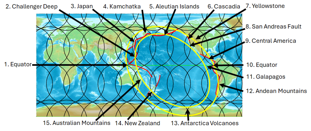
The circular form of the Ring of Fire.

Uncategorized

The Ring of Fire on Equirectangular Map

Drawing the Ring of Fire on an equirectangular map, the main features fall into a narrow zone.

Two of the areas named on this map are often omitted when analysing the Ring of Fire, namely Yellowstone and Antarctica. With Antarctica included, the name ‘Ring of Fire’ can be taken literally, as a whole elliptical form is completed. Following up on this point, the circle is remarkably regular, with symmetric features, such as New Zealand, San Andreas Central Fault and Yellowstone on the minor axis. To be more precise, the San Andreas Fault is found where the inner ring crosses the minor axis, and Yellowstone is located where the outer ring crosses the same axis.

The basic idea by drawing the circle in this way, is the fact that subduction takes place exactly where equator crosses the outer ring within the Philippean Trench at the coast of Indonesia , and the Peru-Chile Trench crosses the same ring also on the equatorial line.

With a more detailed analysis, it can also be shown how the two rings follow the division lines drawn, representing the model introduced here. Examining the subduction zones one by one, a striking consistency between division lines and subduction zones is found.

Considerable research has been carried out regarding the subduction zones, and I like the work of Robert J. Stern a lot, as he has not only carried out a lot of measurements, but also contributed to the study of Earth’s history. Please read his article about the origin of subduction zones: https://speakingofgeoscience.org/2013/04/28/when-did-plate-tectonics-begin-on-earth-and-what-came-before/

Uncategorized

Volcanic Activity near Grindavík on the Reykjanes Peninsula

The volcanic activity near Grindavík can be explained by referring to the interaction between a dyke forming within the volcanic zone, and magma from the dyke finding its way to the surface through earthquake faults. A seismic zone creats a weakness of the crust within the area. The orientation of the dyke is quite different from that of the earthquake faults. According to calculations the dyke is oriented about N43°E, and the earthquake faults trend is directly N-S. Real circumstances are not quite so simple, because the upper most manifestations of earthquake faults are en échelon arranged, divided into smaller systems with NE-SW trend. The dyke, when meeting with the earthquake faults, also bends, or follows the N-S trend near the eruption site. As I have been exploring the possibility that convection rolls are found withn the asthenosphere, and mapping the division lines between them, it is interesting to compare those lines with the conditions at the eruption site. Two downwelling lines of the lower parts of the asthenosphere are found directly below the eruption site itself. To understand the situation better, we should have a look at a map showing this:

This shows how the black division line crosses the Reykjanes Seismic Zone shown with red parallel lines. It is tempting to assume that the origin of magma can be traced to those two division lines directly below the eruption site. Another possibility is that the magma is originated from the upper most division line, alinged NE-SW, found slightly west of the eruption site, flowing at first under the crust along the NW-SE aligned line until it reaches the eruption site area. Then it ascends into magma chambers and finally to the surface.

This site shows many different situations where convection rolls system and real circumstances fit together. This is of course a very good example. The fact that the three eruptions along the dyke which formed under Fagradalsfjall, and the four eruption that have already taken place along the dyke forming at the side of Sundshnúkur have the same petrological origin is consistent with this.

This is an explanation built on many years of research. I have taken part in a series of conferences and meetings, publishing papers where the scientific papers pointing in this direction are cited. I also took part in mapping the South Iceland Seismic Zone, giving me the feeling of how the seismic area of Reykjanes works, as those two systems are connected end-to-end.

To explain the heat flow within the Earth, from radioactivity to eruption, is not easy, but it can be done. This eruption deserves much attention, and among the countless examples shown here, this one of those literally to the point.

The two other seismic zones of West Iceland (BTZ) and South Iceland (SISZ) are added to show how likely it is that the polygons surrounding distinct areas of Iceland really exist. To form a seismic area, pressure is nedded. The faults are all N-S oriented, so regularity is needed. The parallel faults are found side by side in E-W direction, having distinct endpoints, so the area is limited. The only solution for an outer framework is a polygon, exactly as drawn on the map here above. The division lines between convection rolls coincide with this enevitable polygonal shape surrounding the seismic zones. Therefore, it makes sense that the division lines are responsible for shaping the polygons in the first place. It is all about logic.