Uncategorized

How Heat is Conveyed within the Earth

The transfer of heat from Earth’s core to its surface is one of the fundamental processes driving our planet’s dynamics. The temperature difference is immense: the inner core is estimated to be hotter than the surface of the Sun, while the overlying mantle is several thousand degrees cooler. This gradient is sustained because radioactive heat sources are distributed unevenly within Earth’s interior.

Radioactive elements such as uranium, thorium, and potassium are concentrated mainly in the crust and upper mantle. They are chemically incompatible with the iron–nickel alloy that makes up the core and therefore absent from the deep metallic layers. As a result, the core itself does not produce radiogenic heat.

Surrounding the inner core, the outer core is a liquid metal where there is quite obviously space for six different convection cells, shown in countless drawings found in geophysical literature. At the boundary between the outer core and the mantle, the Gutenberg discontinuity, heat is transferred into the lowermost mantle.

The mantle is said to be plastic, because it is balancing between solid and liquid state. On geological timescales it behaves as a very slow, viscous fluid. This allows it to circulate, with hot material rising and cooler material sinking in enormous mantle convection rolls. Such convection provides an efficient mechanism for transferring heat from the deep Earth toward the lithosphere. When this heat reaches the lithosphere, the situation changes. The lithosphere, comprising the tectonic plates, is rigid and brittle. Here, heat can no longer be transferred effectively by convection; instead, it passes upward by thermal conduction, producing the steep geothermal gradient observed in the upper crust.

At certain boundaries, such as mid-ocean ridges, rift zones, and volcanic hotspots, mantle convection currents concentrate and channel heat more directly to the surface. Where two convection rolls meet, the focused upwelling of heat and pressure can act in a way somewhat comparable to the Munroe effect known from the physics of shaped charges: energy becomes concentrated along a narrow path, enabling molten rock to rise through the crust. This focused delivery of heat and magma helps explain the occurrence of volcanism at structurally weak points in the lithosphere.


Heat Radiation and the Core’s High Temperature

An additional factor that deserves close attention is the role of thermal radiation from radioactive elements in the upper mantle and crust. While radiogenic isotopes are unevenly distributed, their heat production is substantial, and the resulting radiation does not remain confined to local surroundings. Laboratory studies have shown that the thermal conductivity of mantle materials increases strongly at high temperatures. This implies that radiative transfer of heat through the mantle becomes increasingly significant under deep-Earth conditions.

From this standpoint, it is logical to consider that heat radiation generated in the upper mantle and crust can reach all the way down to the inner core. This view challenges the traditional assumption that the mantle acts only as an insulating blanket that slows cooling of the core. Instead, the mantle may also act as a medium that allows long-range transfer of radiative energy into the deepest interior.

This has important consequences for how we interpret the origin of Earth’s core heat. Physicists such as Max Planck calculated that if Earth’s interior relied solely on primordial heat left over from accretion, that heat should have dissipated very quickly relative to Earth’s 4.5-billion-year age. By this reasoning, the amount of primordial heat still retained in the core today must be negligible. Similarly, if downward heat radiation from the mantle is sufficient to maintain the core at high temperatures, then the release of latent heat from inner core crystallization also becomes only a minor contribution.

The conventional models that invoke secular cooling and crystallization as the dominant heat sources are understandable, given the historical focus on conduction and convection. However, they do not fully account for the efficiency of radiative transfer in high-temperature mantle materials. My analysis therefore leads to the conclusion that the extraordinarily high temperature of the core can be explained almost entirely by heat radiation from radioactive elements in the upper layers of the Earth. Rather than being a passive reservoir of slowly fading primordial heat, the core is actively sustained by radiative energy generated above it.


Convection and Radiative Balance

This interpretation also reframes how we understand convection within Earth’s main layers. The mantle, outer core, and even the inner core’s boundary layers all fit the geometric conditions for Rayleigh–Bénard type convection to occur: a fluid or semi-fluid medium heated from below (or internally) and cooled from above. For such convection to remain stable over geological timescales, the rate of convective circulation must stay perfectly balanced with the intensity of heat radiation reaching the inner core.

In other words, the deep Earth operates as a finely tuned thermal engine. Radiative input from above sustains the temperature of the core, while convection in the mantle and core ensures the continuous upward transport of heat. This delicate balance drives plate tectonics, fuels volcanic activity, and maintains the dynamic processes that have shaped Earth for billions of years.

The Convection Rolls System.

Uncategorized

Convection Rolls and the Global Logic of Plate Tectonics

The surface of our planet bears the unmistakable marks of forces that operate deep within its interior. Mountains, rift valleys, volcanic arcs, and ocean basins are not random accidents of nature but the result of systematic and persistent geological processes. Among these, the concept of mantle convection, where heat from Earth’s interior drives circulating rolls of plastic mantle, offers a coherent way to understand the global distribution of geological features. When we examine the Atlantic Ocean, the Pacific Ring of Fire, and particularly Iceland’s unique geology, we can see a consistent pattern that points to convection rolls as a guiding force in shaping the planet’s surface.

The Mid-Atlantic Ridge: A Symmetrical Rift

The Mid-Atlantic Ridge is one of the most striking linear features on Earth. Stretching north to south, it runs down the center of the Atlantic Ocean like a seam on a baseball. Along this ridge, tectonic plates are moving apart, and new crust is being created as magma rises to fill the gap. What is remarkable is the symmetry of this system. The forces that shape the eastern Atlantic margins, along Europe and Africa, are mirrored in the geological structures along the western margins, facing the Americas.

This symmetry suggests that the same deep mantle processes operate beneath both sides of the Atlantic. The ridge itself acts as the surface expression of an underlying upwelling zone, hot material rising in a systematic manner from below. The spreading, volcanism, and earthquakes observed along the Mid-Atlantic Ridge are thus not isolated features but the predictable result of convection-driven divergence.

To fully comprehend the effect of convection rolls, it is important to recognize that Earth’s interior is not a single uniform system but a set of layers, each with its own convection dynamics. Convection rolls in different layers may be oriented in different directions, creating complex interactions between them. On top of this, the large-scale convection rolls of the lower mantle are often overlain by smaller rolls in the upper mantle and asthenosphere. These smaller rolls add detail and local variation to the broader global pattern. As a result, surface expressions such as mid-ocean ridges appear at once holistic, reflecting the influence of large-scale mantle circulation, and discontinuous, because smaller-scale convection rolls introduce irregularities and segmentation. This layered and multi-scale system helps explain why Earth’s geological features can seem both systematic and fragmented at the same time.

The Pacific Ring of Fire: A Continuous Arc

Moving to the Pacific, we encounter an entirely different yet equally systematic phenomenon: the Ring of Fire. This chain of volcanoes and seismic zones encircles the Pacific Ocean, from the Andes in South America, up through North America’s Cascades, across the Aleutians, and down through Japan, the Philippines, and New Zealand.

At first glance, the Ring of Fire may seem irregular, since the volcanoes and trenches occur in different geological settings. Yet when viewed through the lens of mantle convection, it becomes clear that similar forces are at work around the entire Pacific rim. Subduction zones, where one plate dives beneath another, are surface expressions of downwelling limbs of convection rolls. The arcs of volcanoes, aligned in systematic chains, form where mantle material melts and rises due to the descending slabs. Just as the Mid-Atlantic Ridge reflects upwelling, the Ring of Fire reflects downwelling and lateral flow. Both belong to the same fundamental system.

Convection Rolls as a Global Framework

The systematic appearance of these geological features, ridge in the Atlantic, arcs around the Pacific, points strongly toward convection rolls as the underlying framework. Instead of imagining Earth’s mantle as chaotic or localized in its motions, we can view it as a series of organized rolls, like giant conveyor belts. These rolls transport heat from the deep interior to the surface, and in the process, they drag along the tectonic plates. It is important to point out that the rolls working against the drift of the plates above tend to be neutral due to slip effect, and the rolls acting in the same direction accelerate or maintain the drift due to no-slip effect. This horizontal drift can only be maintained with ridges and subduction zones, which in turn fit into the pattern of the convection rolls system.

By adopting this perspective, the global distribution of active regions becomes much more comprehensible. Features that might otherwise appear disconnected, the Andes, the East Pacific Rise, the Aleutians, or the Mid-Atlantic Ridge, can be seen as parts of the same coherent system.

Iceland: A Natural Laboratory

Among all the regions where convection manifests at the surface, Iceland stands out as one of the most revealing. Straddling the Mid-Atlantic Ridge, Iceland is literally being pulled apart by the diverging North American and Eurasian plates. The island is intensely volcanic, with eruptions occurring regularly, and geothermal energy bubbling up in hot springs and geysers.

What makes Iceland particularly interesting is the systematic pattern observable in its geology. Studies reveal repeated occurrences of features at roughly 1.5° intervals from east to west. These intervals are not random. They suggest that convection rolls beneath Iceland influence where magma rises and where fissures open. Instead of a single point source or isolated plume, Iceland’s structure implies a rolling system of upwellings and downwellings, each spaced in a consistent rhythm.

This pattern is like a fingerprint of convection rolls imprinted directly onto the surface. It provides one of the clearest local examples of how mantle dynamics can create systematic geological structures.

Extrapolation to Global Geology

If such a system can be identified beneath Iceland, it is logical to extend the same reasoning to other parts of the world. Iceland is not unique in experiencing volcanism or tectonic spreading. It is simply an especially visible case because the ridge rises above sea level there. The same processes occur all along the Mid-Atlantic Ridge, hidden under the ocean. Likewise, the arcs and trenches of the Pacific reveal similar spacing and repetition when studied carefully.

By extrapolating the system of convection rolls outward, one can explain the arrangement of many other active geological areas worldwide. The Mediterranean volcanism, the East African Rift, the Philippine arcs, and even intraplate hotspots may be understood within the same framework. They all represent surface manifestations of a deeper and more systematic circulation of Earth’s mantle.

A Unified Perspective

The strength of this convection-roll model lies in its ability to unify diverse geological observations into a coherent picture. Rather than treating each volcanic chain, rift, or trench as a separate phenomenon requiring a unique explanation, we can see them as interconnected parts of a global circulation system.

In the Atlantic, this system explains the symmetry of spreading ridges. In the Pacific, it accounts for the continuous arc of subduction and volcanism. In Iceland, it reveals itself in the regular spacing of geological features. On a global scale, it provides a logical framework for understanding why geologically active regions appear where they do.

Conclusion

The Earth’s surface is a complex mosaic of geological features, but beneath that complexity lies order. The Mid-Atlantic Ridge’s north–south orientation, the continuous Ring of Fire around the Pacific, and the repeated spacing of structures in Iceland all point toward the same conclusion: convection rolls in the mantle are shaping our planet in a systematic way. By recognizing this pattern and extrapolating it globally, we gain not only a deeper understanding of Earth’s past but also a predictive framework for studying its geological future.

The study of Earth’s interior is far from complete, but each new observation strengthens the view that mantle convection is not a chaotic process but an organized system of rolls. These rolls, moving slowly over millions of years, have carved the face of the planet, lifted mountains, opened oceans, and lit volcanic arcs. From the symmetry of the Atlantic to the fiery arcs of the Pacific, and from the rhythmic geology of Iceland to the restless rifts of Africa, the logic of convection rolls offers a powerful lens through which to read the Earth’s grand design.

Geysir: The most famous geological feature of Iceland.
The wide red line represents large scale lower mantle divisions. Geysir is found just at its side,
but exactly on a division line between smaller convection rolls.

Uncategorized

The circular tectonic drift vectors of Anatolia

The tectonic drift of the Anatolian Plate is notably independent from its surroundings. While the Arabian Plate moves northward, similar to the African Plate, the Anatolian Plate exhibits a counterclockwise rotation. This motion can be examined through the lens of the convection rolls model to see whether it offers any additional insights. The outcome is striking and reveals two key points:

  1. The combined structure of convection rolls and plate boundaries appears to create the conditions for a central pivot point around which the Anatolian Plate rotates.
  2. If a fixed point within the convection model exerts a dominant influence on tectonic drift, then the convection rolls also offer a framework for understanding the subduction of the African Plate beneath the Eurasian Plate.

The map showing drift vectors can be found at:
https://www.tandfonline.com/doi/full/10.1080/19475705.2024.2446588#abstract

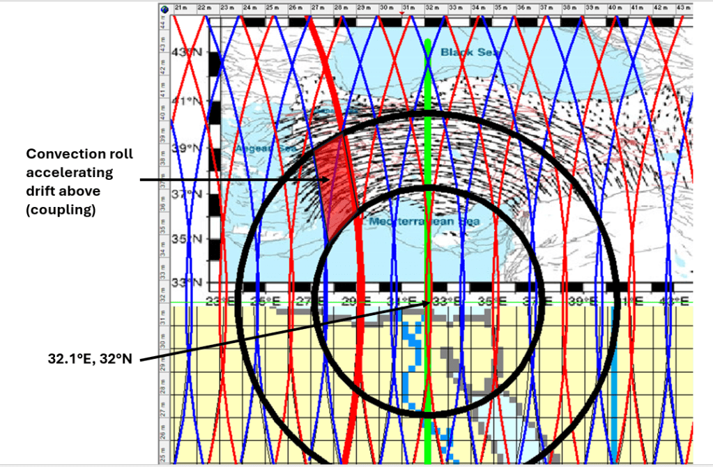
The most significant observation is that this central pivot lies near the 32nd parallel, precisely where two mantle upwelling lines intersect at approximately 32.1°E. Along this latitude, the convection roll system is aligned exactly north–south, making it a key structural feature, comparable in importance to the equator and the 64°N/S parallels. Interestingly, this location corresponds roughly to the eastern edge of the Nile River delta. It has previously been noted that the deltas of the world’s largest rivers—especially the Amazon at the equator—are situated at critical junctions within the convection rolls framework. https://magicmagma.com/2022/10/04/what-do-the-three-famous-rivers-amazon-nile-and-mississippi-have-in-common/

Given this fixed relationship between surface tectonics and mantle convection geometry, the concept of rollback requires reconsideration. In this case, the European continent appears to be drifting away from the latitude at which the African Plate subducts beneath it. Whether we interpret this as northward retreat of the African slab or northeastward drift of Europe, the geological consequences are functionally the same.

The side-view depiction of African Plate subduction shows how numerous geological features have developed over the last 35 million years, since subduction began. These reflect the continuing northeastward movement of the Eurasian Plate, while the northern edge of the African Plate descends beneath it.

This is from https://www.youtube.com/watch?v=cqK-CbuM3Eo

Just to clarify a bit what drives the tectonic drift anomaly of Anatolia, a particular bit of convection roll can be pointed out:

It can also be pointed out that most geothermal activity is found in this part of Turkey. Take a look at this map:

It is from https://www.researchgate.net/figure/Geothermal-map-of-Turkey-MTA-2021b_fig1_365230456

The red area in Western Turkey coincides with the convection roll taking part in driving the rotation of the local tectonic plate. This can explain the geothermal activity anomaly.

Note that the appearence of the aggregate of vectors of GPS drift measurements of the Anatolian Peninsula is not only circular, but also basicly from east to west. The mathematical precision of the drift can only be possible because of a very regular system of convection rolls underneath. The rolls following the drift are coupled to the layers above, the ones opposing are decoupled. Thereby the engine driving this interesting rotational drift of the plate can be explained thoroughly.

Just to clarify further how the convection rolls move the tectonic plate, this drawing is added:

The red areas provide force for the circle to move anti-clockwise in an almost circular way. As previously mentioned, the pivotal point is also a key point within the convection rolls system as a whole, due to the exact N-S alignment of convection rolls at the 32nd latitude.

Uncategorized

Circular aspects of the Ring of Fire

Describing The Ring of Fire according to the map below, the San Andreas Fault and Yellowstone play the main roles. Accordingly, The Ring of Fire covers a rather wide area, mathematically confined. The San Andreas Fault has a section moving continually, as no pressure accumulates due to the fact that the drift direction of the Pacific Ocean Tectonic Plate is exactly parallel to the fault alignment. Just to add one fact, the sliding effect is due to the fact that the Pacific Plate drifts slightly away from the North American Plate at that point, but the North American Plate moves towards the point, so the combined result is a smooth, perpendicular meeting point. This is the most important thing to understand in an attempt to understand the preconditions of the Ring of Fire.

Yellowstone is therefore also a key point of the Ring of Fire. For a manifistation of that statement, we should have a look at a basic geological map of the Yellowstone Caldera:

Calderas tend to be regular, and therefore an elliptical form is used to aproximate the outlines of Yellowstone. Then the major and minor axis of the ellipse become apparent, and they are perpendicular and parallel, respectively, to the edge of the Ring of Fire at that location. The minor is aligned in the same way as San Andreas Fault. It is not necessary to add a detailed map of San Andreas Fault complex here, because everyone knows that it is logically parallel to the Ring of Fire.

Taking this a bit further, the Pacific Tectonic Plate drifts as a whole in one direction. On the contrary, the adjacent plates of America and Eurasia rotate towards the Pacific. The Ring of Fire also includes other plates than the Pacific Ocean Tectonic Plate, as it is defined. Other factors determine its scope too, and there we have the pattern shaped by convection rolls. The different layers of rolls have intersection points, coinciding with the outer and inner edges of the Ring of Fire. That provides the mathematical base for the elliptical form of the Ring of Fire. The way to realize this is simply to trace the two concentric yellow ellipses marking the Ring of Fire, and see how many intersection points each of them coincide with. The width of the Ring of Fire therefore always remains mathematically the same in proportion with the grid formed by latitudes and longitudes.

This description of the Ring of Fire is presently of a secondary nature, because first you have to have knowledge about the Mantle Convection Rolls Model, and then about the Ring and Fire and how it is related to the said model. Besides that, the tectonic drift vectors are not always presented as on the map above. A solid reference frame, and a view from space with GPS should describe tectonic drift in the best way. And it should be noticed that Yellowstone, according to this analysis, is a part of the Ring of Fire. More about this in my paper: https://pangea.stanford.edu/ERE/db/GeoConf/papers/SGW/2024/Thorbjarnarson.pdf

Uncategorized

The Mantle Convection Rolls

Geology can be difficult to comprehend, and there are many examples of misunderstanding the basic principles behind the processes gradually changing our planet. It is generally acknowledged that we still have a scientific frontier when it comes to tectonic drift, explaining location of volcanoes, geothermal areas and seismic zones. Here, an attempt is made to solve the problem and explain many of the remaining questions by analyzing the currents within the mantle. A few things are generally known, because they can be measured with confidence. That includes the thickness of layers, or depth of discontinuities, and the chemical properties of the mantle. We also know that the thermal gradient is adiabatic below 120 km depth. It is found that above 120 km the mantle does not flow, no convection takes place there. On the contrary, below 120 km convection does take place. As the thermal gradient is adiabatic, the mantle material is always on the verge of becoming stagnant. These conditions can be imitated in laboratories, and it is then discovered that the convection leads to formation of convection rolls, with the same height and width. This can be used to make a model of convection rolls within the Earth. The rotation of the Earth must be considered, but there are ways to do that according to physics, and thereby the location of convection rolls can be found. After doing this, surface features can be compared to the modelled convection rolls, and it turns out that everything fits. All over the world, volcanoes, geothermal sites, seismic zones, subduction zones and other features can be readily explained. This means that in the future, utilization of various resources will become much more systematic than today. This will improve our understanding of tectonics and the basic forces leading to tectonic drift. And it is easy in a way, because the convection rolls have been located very accurately. The different layers affect each other, and the surface, often in ways that makes it difficult at first to see the relationship between cause and effect. But with the comprehensive version of the model at hand, the role of each layer can be studied. With the three papers already published, examples about mid-ocean ridges, subduction, volcanic zones and seismic areas have been provided. Just take the time to learn what our planet is like. Icelandic geology made it possible to start this job, because Iceland is like a natural laboratory. Global aspect is also important, though, and by combining knowledge about the Earth in general and Iceland in particular, the publication of these papers could be realized.