A manifestation of the polygon system inherent in the layout of convection cells beneath Iceland are the EW-axis and NS-axis found along the country. It can be drawn in a very simple way on a map:
Want to see more?
A manifestation of the polygon system inherent in the layout of convection cells beneath Iceland are the EW-axis and NS-axis found along the country. It can be drawn in a very simple way on a map:
Want to see more?
The volcanic sites of Sveifluháls and Brennisteinsfjöll clearly have the same alignment as the West Volcanic Zone, that is N43°E. But the peninsula on which most of Reykjavik is built points N54.8°W. It is 1/4 of the angle between convection rolls and EW axis alignments. The tectonic direction can be detected from the Bláfjöll area.
As for Elliðaárdalur valley, the NS axis and EW axis meet where some of the geothermal sites are found. The rims of the extinct Viðey volcanic site are found in the area, but these tectonic settings adhere the preconditions for ground water reaching the hot bedrock and ascend towards the surface.
The basic tectonic framework of the surroundings of Reykjavik
The Golden Waterfall is mainly divided into two steps, the upper one roughly aligned EW and the lower one NS. To be more accurate, the upper step is combined of two smaller steps, namely the upper most division line accurately aligned EW, and the lower rocks with the direction N77.8°E. The next step which is aligned N10.4°E is in line with the upper most part of the gorge extending down from the waterfall.
Both N77.8°E and N10.4°E are derived from the main tectonic direction of N41.4°E of the convection rolls and the West Volcanic Zone with its edge only about 10 km to the west, whereas N77.8°E is 1/4 of the angle from direct north-south to N41.4°E, and N10.4°E is 1/4 of the angle from east-west to N41.4°E.
This Google map shows the waterfall’s context with EW axis and the volcanic zone direction:

To see it closer:

The calculated values of tectonic directions show the details of the three main alignments of the waterfall.
The Tjörnes fracture zone is monitored on a day to day basis by the Meteorological Office of Iceland. Usually the epicenters show a pattern along the fracture zone, but these days it is different. The alignment is from NW to SE and even more northerly direction is found. This shows that the underlying convection rolls are playing a dominating role creating these earthquakes. On the table showing the strength and depth of the earthquakes it is apparent many of the earthquakes are originated around 10 km below the surface. It is close to the ductile part of the tectonic plate, where the effects of convection cells can be manifested. Therefore the pattern of the Tjörnes faults, more connected to the horizontal forces on the brittle part of the plate does not appear here in a clear way. The pattern of covection cells has been added to the information provided by the Meteorological Office of Iceland, and the main line between convection rolls darkened:

The resemblance is sometimes even clearer than this. Just follow the events on vedur.is.
The hotspring area of Geysir is found within the realms of an old volcanic system. It has existed for thousands of years (http://www.geysircenter.is/?c=webpage&id=102&lid=98&option=links) but Geysir as we know it for the last few centuries is first mentioned in 1294 when it was reactivated by a big earthquake.
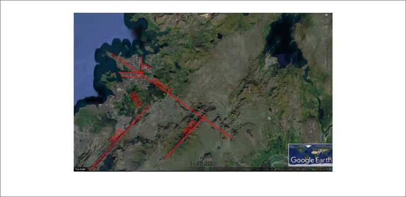
According to the analysis of convection rolls, Geysir is located where it is due to the tectonic effects of the polygon surrounding the Southern Lowlands of Iceland. The outer boundary of the polygon of the NE-side, close to the north corner, is under the hot springs. Here you can see the outlines of the polygon marked with red lines:

Besides that, the horizontal pressure within the polygon has created a secondary tectonic alignment, and the relevant fractures cross the area. Here these fractures are marked with red:

The Google Earth map shows the fractures clearly. The polygon has the alignment of N41°E and the derived tectonic alignment has the direction N54°E. It is 1/4th of the angle between convection roll alignment and EW axis, formed with this regularity due to stability conditions within the ductile part of the tectonic plate.
Besides this, the EW tectonic alignment is also apparent in the slopes of the mountain Bjarnarfell west of the Geysir area.
All this ensures a steady flow of underground water through the Geysir area at the depth necessary to bring heat to the surface.
The two geysers, Geysir and Strokkur are aligned along a tectonic line which can also be calculated (N30.9E) which is 1/4th of the angle between convection roll alignment and NS axis. It suggests that the two geysers are connected with an underground fracture.

The Geysir Hotspring Area
These rules of tectonic line arrangement are found all over the world, and become quite explicit at hot spring areas like Geysir.
