Uncategorized

The convection rolls shaping the volcanic zones of Iceland

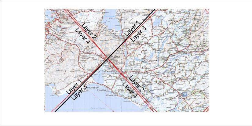
Big convection rolls obviously shape the Atlantic Ocean from underneath. Smaller convection rolls are responsible for marking the details of volcanic zones in Iceland. The upper most convection rolls are found side by side as this drawing shows:

Gamla kortið - spjald

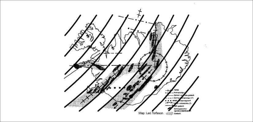
The resemblance to this map is quite obvious, as the darkened areas show volcanic zones. The volcanic zones abbrevieated as WVZ and EVZ fit perfectly, along with CVZ and by referring to other convection layers the NVZ and SVZ along with ÖVZ can be explained. Each convection roll spans 1.5° from east to west, swaying according to calculation under the country. The rolls can not be straight, due to the rotation of the Earth and the fact that the mantle is flowing. This layer in particular has a horizontal flow component to the south, swaying slightly to the right as all moving particles have to do on or inside the rotating Earth.

Uncategorized

Mantle division in SW-Iceland: How accurately can it be pinpointed?

The difference between division line between plates and convection rolls can be understood quite easily in the south of Iceland.

Þorlákshöfn-Hveragerði

The central point east of Hveragerði is one of the most appearent in the world, because the N-American and Eurasian plates meet there.

The main division line of lower mantle is oriented SW-NE. The lines between the upper most four layers form an “X”, due to the coincidence that the division lines all meet at 64°N.

Middle - explanation

Each line stands for one of the four convection rolls layers found between 120-410 kilometers deapth. Besides that, the lower mantle cells meet below the black line. For those new to this subject (that is everyone), the intersection zone adds some level of complexity. Everywhere else than at these latitudes, only two layers of upper more convection rolls are found, and only a single set of lower mantle convection rolls. North of 64°N, the layer 1 convection cells have a stronger effect than layer 3. The rolls of layer 1 only reach south to 60.7°N, so south of there layer 3 becomes the upper most layer. At 64°N the thickness of all layers is equal, but north of there layer 1 is thicker than layer 3 and becomes more dominant.

Uncategorized

Understanding the mantle division at the NE of Iceland – how to visualize the layers of convection rolls:

As can be seen on this map, two lines are found between Akureyri and Húsavík. The one extending from south of Akureyri towards Skjálfandi Bay just west of Húsavík is the main division line of the lower mantle. It is also the division line of upper most convection cells. These two towns can therefore be introduced as being close to the mantle division line, just like the towns Þorlákshöfn and Hveragerði in the southern part of Iceland.

Akureyri-Húsavík

As there are four layers of convection rolls below Iceland, four sets of division lines appear on the map. This rises the level of complexity, so that those not aware of the layering can not understand the map. Therefore an exhibition was prepared, so the 3D perspective of the layers could be visualized.

20180709_142533

Each layer is orianted differently, so sets of lines leading to four different directions appear on the surface.


Uncategorized

EW-alignment of Eyjafjallajökull-Katla

One of the most popular hiking routes in Iceland is over Fimmvörðuháls, between the two volcanic sites of Eyjafjallajökull and the Katla caldera. Actually, the two volcanic systems intersect each other. So do the two glaciers covering the sites.

Eyjafjallajökull has elliptical form, with the long axis oriented exactly EW. Farther along that axis to the east, the real Katla is found. Directly north of Eyjafjallajökull is Hekla.

These EW and NS stories are not just a coincidence to be neglected by us all. These stories include a lot of geology to study.

Eyjafjalljökull - Katla - EW axis

In Hveragerði Information Center, a model of this area is exhibited. It gives us a clearer view.

20180914_144309

Model of Eyjafjallajökull

Basics

And if someone has forgotten how Katla is located on an intersection point, here is a map for review. The top crater of Eyjafjallajökull has a curious position exactly in the middle of the relevant polygon, and thereby in the middle of the East Volcanic Zone.