
Abstract
A comparison of the proposed tectonic-ring geometry with major tectonic and volcanic features around the Pacific suggests that several different types of spatial correspondence should be distinguished. Some geological structures follow the margins of the modeled ellipses, others occur near the ends or extensions of their axes, while still others correspond more closely to the smaller convection-roll boundaries predicted within the upper mantle. The Red Sea, Gulf of California, and Philippine Sea form a particularly useful three-part comparison because each occupies an overlap zone between two of the three large tectonic-ring systems, yet each displays a different tectonic expression. Within the Pacific system itself, San Andreas, Yellowstone, Hawaii, Hikurangi–Alpine Fault, Changbaishan, Galápagos, Izu–Bonin, El Tatio, the Valley of Geysers, and Erebus occupy different but geometrically distinctive positions. The importance of these correspondences lies not in claiming that an ellipse directly creates a rift, fault, volcano, or subduction zone, but in testing whether deep geometrical structures are repeatedly reflected in the location and orientation of independently established geological features.
1. Two superimposed geometrical systems
The analysis requires a distinction between two scales.
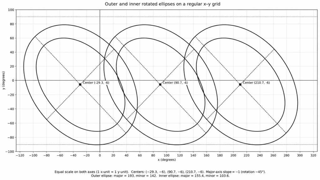
The first is the tectonic-ring system, represented by large ellipses. In the proposed model these forms are associated with deep mantle organization, ultimately related to the transition near the 670 km discontinuity. Their surface expression should therefore not necessarily be expected to appear as a single fault or volcanic line. Instead, the ellipses may be expressed as broad tectonic margins, curved rift systems, changes in structural regime, volcanic provinces, or zones in which pre-existing lithospheric weaknesses are preferentially reactivated.
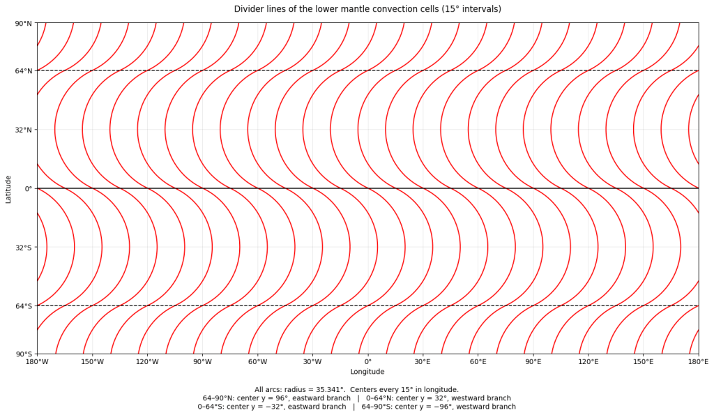
The second system consists of the considerably smaller mantle convection rolls. The 2024 Stanford paper defines a family of circular division lines whose centers occur at 1.5° intervals along 32°N. In that analysis, the western edge of the Izu–Bonin system follows the modeled line with Cn=173.8, beginning near Mount Fuji, while the volcanic chain farther east follows approximately Cn=175.3. The Izu–Bonin system is about 3° wide, corresponding in the model to two upper-mantle convection rolls.
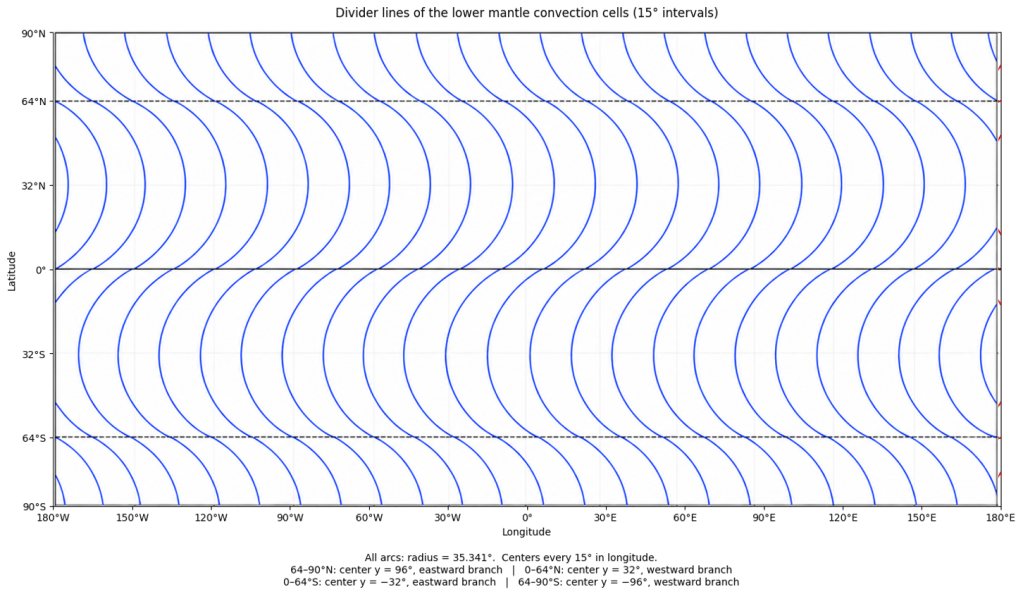
Thus the two geometries need not have identical surface expressions. A tectonic-ring ellipse may determine the broad position and curvature of a tectonic domain, while convection-roll boundaries may appear more directly as linear or arcuate faults, volcanic chains, ridge segments, or boundaries between tectonic compartments.
This distinction appears repeatedly in the examples considered below.
2. Three corresponding overlap zones
One of the most striking geometrical relationships involves three widely separated regions: the Red Sea, the Gulf of California, and the Philippine Sea region. In the proposed geometry they occupy the three possible pairwise overlaps among the Atlantic, Pacific, and Indian Ocean tectonic-ring systems.
Red Sea — Atlantic–Indian overlap
The Red Sea occupies the overlap between the Atlan ic and Indian Ocean ring systems and closely follows the outer Atlantic ellipse over a long distance.
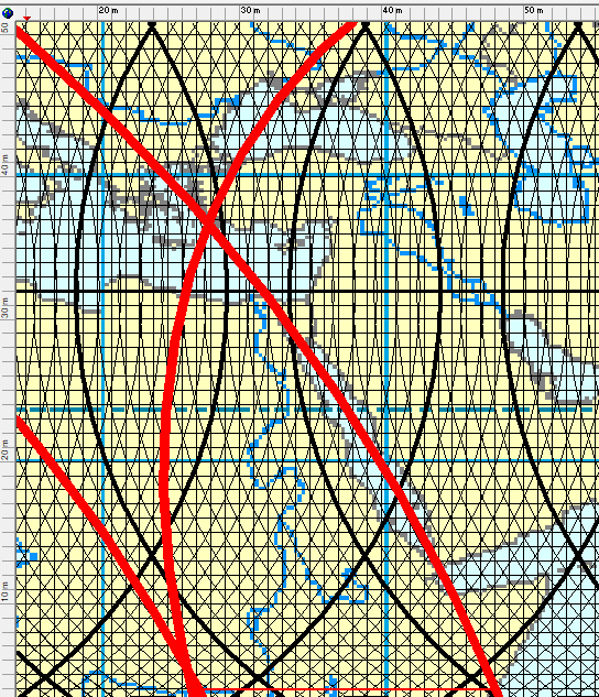
Its conventional geological interpretation is that of an active continental rift progressing toward oceanic spreading. The important point for the present analysis is not that the ellipse is claimed to have “formed” the Red Sea. Rather, the independently formed rift follows the calculated large-scale curvature of the ellipse unusually well.
The detailed structure adds another level. Individual axial depressions, fracture zones, spreading segments and accommodation zones subdivide the Red Sea. These divisions can be compared with the smaller convection-roll system rather than with the deep ellipse itself. Thus the Red Sea provides an example in which: the ellipse describes the large-scale curved framework, while convection-roll boundaries may correspond to the internal segmentation.
Gulf of California — Atlantic–Pacific overlap
The Gulf of California occupies the corresponding overlap between the Atlantic and Pacific systems and follows the inner Pacific tectonic-ring margin.
Geologically, however, it is not simply another Red Sea. It combines spreading centers with transform faults and connects northward into the San Andreas system. USGS descriptions emphasize precisely this combination of spreading centers and transform displacement south of the San Andreas Fault. The similarity with the Red Sea is therefore geometrical rather than identical in tectonic mechanism.
Both are:
- elongated tectonically active zones,
- related to plate separation,
- strongly segmented,
- situated along modeled ellipse margins,
- and, in the present geometry, reach a corresponding northern limit close to 32°N.
Philippine Sea — Indian–Pacific overlap
The third overlap zone is fundamentally different. Here a large, distinct plate domain has developed between major convergent boundaries.
The Philippine Sea Plate is unusual in conventional plate tectonics because it is almost completely surrounded by zones of convergence. The Pacific Plate descends beneath its eastern side at the Izu–Bonin, Mariana, and Yap trenches, while the Philippine Sea Plate itself descends beneath Japan and Eurasia along the Nankai–Ryukyu system.
Within the tectonic-ring geometry, the region is particularly interesting because the inner and outer Pacific ellipses form major lateral bounds, while an Indian Ocean ellipse runs obliquely across the broader domain. Thus the three overlap zones are analogous without being duplicates:
Red Sea — extension
Gulf of California — extension plus transform motion
Philippine Sea — predominantly convergence and subduction, with internal back-arc extension
What all three share is not a single tectonic mechanism but the existence of major tectonic boundaries within corresponding ring-overlap sectors.
3. The minor axis of the Pacific ellipse
A second group of relationships emerges from the geometry of the minor axis of the inner Pacific ellipse.
This axis is particularly important because several otherwise unrelated geological features occur at geometrically distinctive positions along it or its continuation.
San Andreas — the northeastern axis end
At one end of the minor axis, the axis reaches the inner Pacific ellipse in the California region.
This is geometrically special because at the end of an ellipse’s minor axis, the tangent to the ellipse is parallel to its major axis. Thus three quantities can be compared independently:
- the location of the modeled ellipse,
- the tangent direction of the ellipse,
- the direction of relative plate motion.
The San Andreas Fault is the transform boundary between the Pacific and North American plates, and the Pacific Plate moves northwest relative to North America.
Consequently, in the model the California location represents more than a simple coincidence between a fault and an ellipse: the plate-motion direction, the major orientation of the fault system, and the local tangent of the ellipse are broadly concordant.
The Gulf of California then continues the tectonic activity southward while following the inner ellipse margin.
Yellowstone — continuation beyond the ellipse
The same minor axis does not terminate geometrically at California. When extended beyond the ellipse, it continues inland toward the Yellowstone volcanic system.
Yellowstone is a large continental volcanic field with three major volcanic cycles during the past approximately two million years; its most recent lava flow is about 77,000 years old.
Thus Yellowstone represents a different category of correspondence:
San Andreas occurs at the axis–ellipse intersection; Yellowstone occurs along the continuation of the same axis beyond the ellipse.
This is important because the model does not require the geological manifestation to remain the same. A transform boundary at one geometrically special point and an intraplate volcanic system farther along the same axis are very different surface expressions.
5. Hawaii — a Central Symmetry Axis in the Convection Roll System
4. Hawaii — a Central Symmetry Axis in the Convection-Roll System
The relationship between Hawaii and the Pacific tectonic-ring system is more complex than a simple correspondence with an axis of an ellipse. Hawaii should not be interpreted as lying on a geometrically defined major or minor axis of the Pacific ellipses. Instead, its significance appears to be connected primarily with the large-scale convection-roll geometry of the lower mantle.
A major set of lower-mantle convection-roll boundaries occupies a central position within the Pacific system. These boundaries are arranged symmetrically on either side of a north–south axis passing through the Hawaiian region. In the model, the principal lower-mantle boundaries on the northern and southern sides of the equator can therefore be regarded as mirror-related across this axis.
The importance of the Hawaiian north–south axis is consequently not derived directly from the mathematical equation of the Pacific ellipses. Rather, it represents a central symmetry line of the underlying convection-roll framework upon which the larger tectonic-ring geometry appears to be superimposed.
A comparable relationship occurs in the other major tectonic-ring systems. In the Atlantic, a principal lower-mantle convection boundary occupies a central position with respect to both the Mid-Atlantic Ridge and the Atlantic tectonic-ring ellipses. A corresponding central relationship can also be identified for the Indian Ocean tectonic-ring system. Thus, in all three cases, the large tectonic ellipses appear to be geometrically organized with respect to major lower-mantle convection boundaries.
This distinction is important. The Pacific ellipses themselves do not provide an obvious direct mathematical reason why Hawaii should occupy its particular position. Instead, the relationship appears at a deeper structural level: the lower-mantle convection-roll boundaries form a central framework, and the tectonic-ring ellipses are arranged relative to that framework.
Hawaii lies close to the north–south symmetry axis of this central Pacific convection-roll structure. This makes its position different from sites such as San Andreas or the Alpine Fault, which are related directly to geometrically distinctive points on the ellipse margins. Hawaii is instead associated with the internal organization of the convection system underlying the entire Pacific ring.
Kīlauea, at approximately 19.4°N, 155.3°W, is one of the most active oceanic volcanoes on Earth. In conventional geological interpretation, Hawaiian volcanism reflects a long-lived mantle hotspot beneath the moving Pacific Plate. Within the present model, the additional observation is that this exceptionally persistent volcanic system occurs close to a major north–south symmetry axis of the modeled lower-mantle convection framework.
The proposed correspondence may therefore be summarized as:
lower-mantle convection-roll boundaries
→ arranged symmetrically around a central N–S axis
→ Hawaii lies close to this axis
→ the same convection framework occupies a central position relative to the Pacific tectonic-ring ellipses.
This type of relationship appears to have analogues in the Atlantic and Indian Ocean ring systems. Hawaii should therefore be regarded not primarily as an “ellipse-axis” feature, but as a possible surface expression associated with the central lower-mantle convection geometry around which the Pacific tectonic-ring system is organized.odel is therefore its relationship to the internal symmetry of the Pacific ellipse, rather than to its rim.
5. New Zealand — the opposite end of the minor axis
The southwestern end of the same Pacific minor axis reaches the New Zealand region, close to the major transition involving the Hikurangi Subduction Zone, Marlborough Fault System, and Alpine Fault.
This is again an independently exceptional tectonic location.
The Alpine Fault forms the major onshore Pacific–Australian plate boundary through the South Island and extends roughly 600 km. The Marlborough fault system transfers plate-boundary motion between the Alpine Fault and the Hikurangi subduction system.
Thus the two ends of the same modeled minor axis correspond to two very different but major plate-boundary systems:
California → San Andreas / Gulf of California
and
New Zealand → Hikurangi / Marlborough / Alpine Fault
The symmetry is geometrical, not tectonic: one side is dominated by transform and extensional motion, the other by a transition between subduction, strike-slip motion, and oblique continental collision.
6. The Pacific–Antarctic geometrical connection
The New Zealand end of the Pacific minor axis also provides a connection to the Antarctic ellipse.
In the model, continuation of this geometry reaches a special point on the minor axis of the Antarctic ellipse. From this Antarctic axis-end another geometrically defined line can be followed northward.
This produces a second major north–south relationship, distinct from the Hawaii central meridian.
Valley of Geysers
The modeled Antarctic-related meridian is close to 160°22.5′E.
The Uzon–Geysernaya volcanic complex and Valley of Geysers in Kamchatka are situated almost exactly in this longitude sector. Smithsonian gives Uzon at approximately 54.49°N, 159.97°E; the Valley of Geysers lies along the eastern part of this volcanic–geothermal complex.
The longitudinal difference from the modeled axis is only about four-tenths of a degree; when latitude is taken into account, the transverse separation is of the order of only tens of kilometres.
This is a particularly interesting correspondence because the Valley of Geysers is one of the world’s most remarkable hydrothermal systems and lies within the highly active Kamchatka volcanic arc.
Erebus
At the Antarctic end, Mount Erebus lies within the same broader geometrical sector. Erebus is the southernmost active volcano on Earth and maintains a persistent summit lava lake.
Its match to the exact north–south line is less precise than that of the Valley of Geysers, and this difference is worth preserving rather than forcing a perfect fit. The important observation is that the Antarctic axis system passes through a region characterized by exceptional volcanism, with Erebus lying nearby.
Thus the Antarctic connection suggests another possible hierarchy:
precise axis correspondence at Valley of Geysers; broader axial-sector correspondence around Erebus and adjacent Antarctic volcanism.
7. Fuji and Izu–Bonin: the convection-roll system becomes dominant
Izu–Bonin is one of the clearest examples showing why the tectonic-ring ellipses and the smaller convection-roll geometry must not be conflated.
The 2024 analysis identifies the western Izu–Bonin boundary with the convection-roll line:Cn=173.8
which can be followed southward from Mount Fuji. The central volcanic line is associated with approximately:Cn=175.3.
The paper notes that the full Izu–Bonin system is about 3° wide, corresponding to two 1.5° upper-mantle convection rolls.
Fuji itself is at 35.361°N, 138.728°E and is a subduction-related stratovolcano; its last known eruption was in 1708.
At the southern end of the larger Izu–Bonin–Mariana system, Challenger Deep enters the model in yet another way: the Stanford analysis associates it with a modeled lower-mantle division line.
Thus this arc provides a particularly useful demonstration of nested geometry:
tectonic-ring framework → broad Pacific setting
lower-mantle division → large arc geometry
upper convection-roll divisions → individual arc margins and volcanic chains
8. Changbaishan — close correspondence with the outer Pacific ellipse
Changbaishan represents another category.
Unlike Fuji, it is not on a simple active oceanic trench–volcanic arc pair. Smithsonian classifies it as an intraplate continental volcano, centered near 41.98°N, 128.08°E. It contains a large summit caldera and a complex basaltic-to-rhyolitic volcanic history.
In the present tectonic-ring calculation, the outer Pacific ellipse passes extremely close to Changbaishan — of the order of only a few tens of kilometres.
This is therefore best classified as an ellipse-margin correspondence, rather than a convection-roll example.
Its importance lies precisely in its unusual tectonic context: a major volcanic center that is not simply situated on the main Pacific trench.
9. El Tatio — superposition of two influences
El Tatio in northern Chile is another distinctive example, but the match is less exact.
The geothermal field lies at approximately 22.33°S, 68.01°W, within the Central Andes volcanic environment generated by Nazca–South America convergence. It consists of numerous geysers, hot springs, fumaroles, and other hydrothermal manifestations.
The outer Pacific ellipse passes through the same broad sector but does not run directly through El Tatio; our calculation places El Tatio roughly 150–160 km from the modeled ellipse line.
This is therefore not best presented as a precise ellipse intersection.
Instead, El Tatio may be a particularly useful example of superposition:
a broad positional influence related to the Pacific tectonic-ring margin combined with more local control from the upper-mantle convection-roll geometry.
This interpretation is especially relevant because the 2024 analysis already finds extensive correspondence between modeled upper-mantle rolls and the distribution of South American volcanic arcs and their subdivision into individual segments.
In other words, the ellipse may determine the broader tectonic corridor while the smaller convection rolls more closely determine where individual volcanic or geothermal systems occur.
10. Galápagos — an intersection of two inner ellipses
Galápagos may be among the most geometrically distinctive sites considered here.
In the present calculations, the inner Pacific tectonic-ring ellipse and the inner Atlantic tectonic-ring ellipse intersect close to the equator at approximately 92.3°W. This places their intersection immediately west of the Galápagos archipelago. Fernandina, the westernmost major island, lies at 0.37°S, 91.55°W and is the most active Galápagos volcano and the one nearest the Galápagos mantle-plume center.
Galápagos is also located near the Galápagos Spreading Center, where new oceanic crust is produced between the Cocos and Nazca plates. USGS notes that the spreading center and its fracture systems have interacted with the hotspot and have influenced the development of the archipelago. Consequently, Galápagos is not merely “near the Pacific ellipse.” It represents a more specific geometry:
inner Pacific ellipse
× inner Atlantic ellipse
≈ Galápagos hotspot–ridge interaction zone.
This makes Galápagos analogous to the other ellipse-intersection regions discussed earlier, but on a smaller and exceptionally volcanic scale.
11. A hierarchy of geometrical correspondences
These examples suggest that it is useful to stop treating all matches as equivalent. At least six distinct classes can be recognized.
Ellipse-margin correspondence is represented by the Red Sea, Gulf of California, Changbaishan, and parts of the Andean system.
Ellipse-overlap correspondence appears in the Red Sea, Gulf of California, and Philippine Sea comparison.
Axis-end correspondence occurs at San Andreas and the Hikurangi–Alpine Fault region.
Axis-extension correspondence includes Yellowstone and the continuation connecting the Pacific and Antarctic systems.
Central-meridian correspondence characterizes Hawaii.
Ellipse-intersection correspondence is illustrated especially well by Galápagos.
A seventh type is then required:
ellipse–convection-roll superposition, of which El Tatio may be a useful example.
Finally, the Izu–Bonin system demonstrates direct convection-roll correspondence, where the smaller roll geometry appears more important than the large ellipse itself.
12. Why the different tectonic expressions matter
The geology of these sites is extraordinarily diverse.
San Andreas is a transform boundary.
Yellowstone is a continental volcanic field.
Hawaii is an oceanic hotspot chain.
Hikurangi is a subduction zone.
The Alpine Fault is a major oblique strike-slip plate boundary.
Izu–Bonin is an oceanic subduction arc.
Changbaishan is classified as an intraplate volcano.
El Tatio is an Andean geothermal system.
Galápagos combines hotspot volcanism and nearby seafloor spreading.
The Valley of Geysers is a subduction-related geothermal system.
Erebus is an active Antarctic volcano.
Their conventional geological explanations therefore remain different.
The proposed importance of the ellipse framework is not that all these features must have the same immediate cause.
Instead, the hypothesis is that a deeper, large-scale mantle geometry may influence where different tectonic processes are preferentially expressed, while plate motion, lithospheric inheritance, slab geometry, crustal thickness, local stresses, and shallower convection determine the form that the surface response ultimately takes.
This could also explain why some correspondences are remarkably sharp while others are diffuse.
A shallow convection-roll boundary might generate a relatively precise structural alignment. A geometry rooted hundreds of kilometres deeper may be expressed over a considerably broader surface belt.
13. From visual correspondence to a quantitative test
The strongest way to develop this analysis further is therefore not to demand perfect correspondence at every locality. Instead, each predicted feature can be assigned to its geometrical class before comparing it with the geology.
For example:
San Andreas: distance from minor-axis endpoint + angle between plate-motion vector and ellipse tangent.
Yellowstone: perpendicular distance from extended minor axis.
Hawaii: Centrally located lower mantle convection rolls divisions.
Hikurangi–Alpine: distance from the opposite minor-axis endpoint.
Valley of Geysers: distance from the Antarctic-derived N–S axis.
Changbaishan: shortest distance to the outer Pacific ellipse.
El Tatio: distance to ellipse plus distance to the relevant upper convection-roll boundary.
Galápagos: distance from the calculated intersection of the inner Pacific and Atlantic ellipses.
Fuji–Izu–Bonin: distance from the predicted Cn=173.8 and Cn=175.3 convection-roll curves.
This approach would make it possible to distinguish genuinely precise matches from broad regional ones and would considerably strengthen the argument by avoiding the impression that geological locations were selected first and geometrical lines fitted afterwards.
Conclusion
Taken individually, any one correspondence could be accidental. Taken together, however, the locations form a structured set that deserves systematic testing.
The three great overlap zones — Red Sea, Gulf of California, and Philippine Sea — all coincide with major tectonic boundaries despite their very different tectonic expression.
Within the Pacific ellipse itself, the minor axis connects San Andreas, the central geometry associated with Hawaii, and the Hikurangi–Alpine region, while its extension relates to Yellowstone and continues geometrically toward the Antarctic system.
The Antarctic axis geometry in turn leads toward the Valley of Geysers and passes through an Antarctic volcanic sector that includes Erebus.
Elsewhere, Changbaishan closely approaches the outer Pacific ellipse, El Tatio appears compatible with superimposed ellipse and upper-roll influences, and Galápagos occupies an especially notable intersection of the inner Pacific and Atlantic ellipse margins.
Finally, Fuji–Izu–Bonin–Mariana demonstrates that the smaller convection-roll system can produce a much more precise surface alignment than the deep ellipses themselves, consistent with the distinction between broad deep-mantle geometry and shallower structural control developed in the model. The 2024 Stanford analysis explicitly identifies the Izu–Bonin arc, South American volcanic zones, and other Pacific subduction systems as tests of this finer convection-roll geometry.
The emerging picture is therefore not of a single ellipse “creating” faults or volcanoes. It is of a nested geometrical framework in which ellipse margins, axes, axis extensions, intersections, and smaller convection-roll boundaries correspond to different levels of tectonic organization. That distinction may be essential for understanding why the model sometimes produces an exceptionally precise match and elsewhere appears only as a broader regional influence.


