Geographic Setting
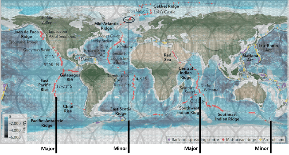
There are two particularly prominent north–south tectonic boundaries on Earth. The first is the Mid-Atlantic Ridge, which on the simplest world maps appears to extend almost continuously from the Arctic to the Antarctic. At its southern end, however, the ridge connects with the circum-Antarctic ridge system that surrounds Antarctica. The same applies to the Central Indian Ridge and the East Pacific Rise.
New Zealand is also situated along a plate boundary connected to this Antarctic ridge system. South of New Zealand lies the Puysegur subduction zone, where the Australian Plate descends beneath the Pacific Plate.
The Mid-Atlantic Ridge and the subduction systems of the western Pacific divide the Earth into two nearly equal halves, corresponding approximately to the eastern and western hemispheres. For this reason, it is useful to examine their continuity from a South Pole perspective.
When the oceanic ridge system surrounding Antarctica is viewed from a polar perspective, it can be approximated by an idealized ellipse. The construction of this ellipse is described below and serves as a geometric reference framework throughout the remainder of this discussion.
Defining the Ellipse of the Ring of Fire
An idealized ellipse of the Ring of Fire can be constructed
 The Ring of Fire
.
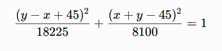
The ellipse is defined on a regular coordinate system by a minor axis extending between the points
(0,-45) and (90,45)., where x=0 is actually 170°E on the World Map. The Ring of Fire can then be drawn on an equirectangular map. The major axis is perpendicular to the minor axis and is 1.5 times longer.
The centre of the ellipse is therefore (45,0),
with a semi-minor axis b=45\sqrt{2}
and a semi-major axis a=67.5\sqrt{2}.
The resulting ellipse is rotated by (45^\circ) relative to the coordinate axes and can be expressed by the equation
Cartesian equation of the ellipse:
In parametric form:
x=45-67.5\cos t+45\sin t
y=67.5\cos t+45\sin t
for 0\le t < 2\pi.
To position the ellipse on the Earth, the coordinate point
(90,45) is assigned to 110^\circ W,;45^\circ N,
which places the opposite end of the minor axis at 160^\circ E,;45^\circ S.
This geometric construction is not intended to reproduce the Ring of Fire exactly. But the simplicity of the minor axis, extending diagonally 90° east and 90° from south to north, is one aspect, and that the major axis is 1.5 times longer is another.
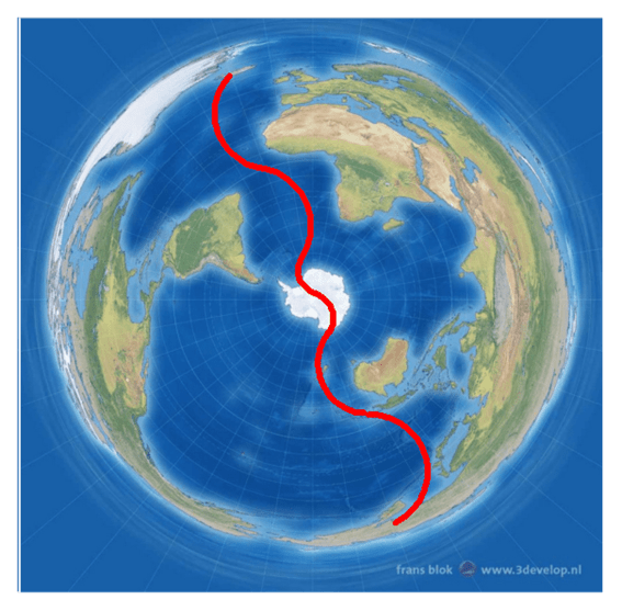
Atlantic Ocean – Antarctica – Ring of Fire
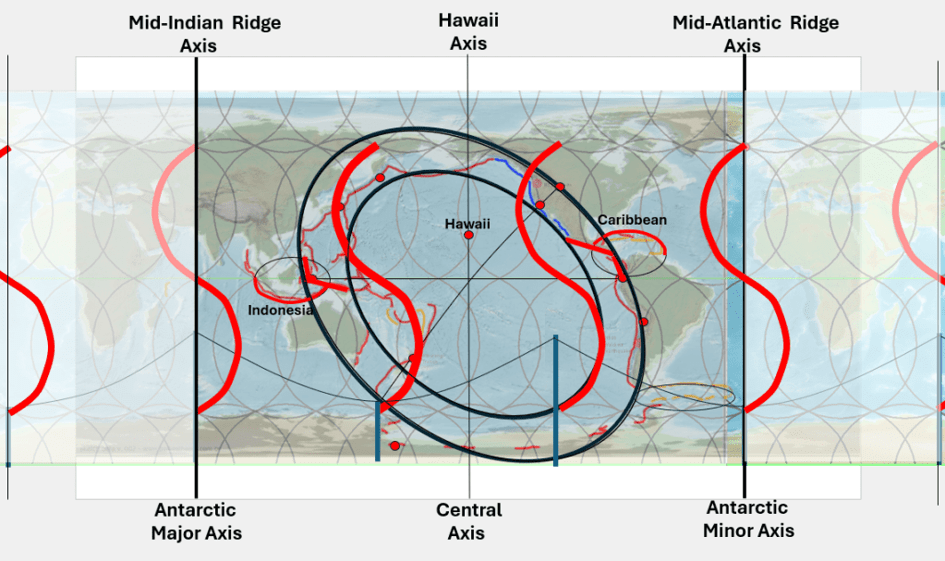
By placing Antarctic-centred maps above one another, these relationships become easier to compare. Both Atlantic-centred and Pacific-centred map projections are useful because most people are not accustomed to viewing maps upside down.
Mantle-flow boundary lines are drawn onto these maps. One of these boundaries, shown more prominently than the others, passes through Iceland and continues southward along the North Atlantic toward the equator, where it bends in the opposite direction along the South Atlantic. The polar portion of this mantle-flow system then continues with an opposing curvature toward the South Pole itself.
On the lower Atlantic-centred map, a corresponding boundary is drawn between the poles. The separation between the two lines is exactly 180°. Although the lines do not appear to connect directly at the South Pole, it should be remembered that the South Pole is a single point. The boundary therefore forms a continuous line around the Earth.
The curvature is such that a particle moving horizontally within the mantle along this path would effectively follow a straight trajectory when Earth’s rotation and spherical geometry are taken into account.
The Unique Position of New Zealand
New Zealand occupies a particularly distinctive position within this framework. The exact relationship between the volcanic zone of the North Island and the inner boundary of the Ring of Fire is of secondary importance. More significant is the Alpine Fault, which cuts across the trend of the Ring of Fire along almost the entire length of the South Island.
When the Ring of Fire is traced as a complete structure, another major fault system appears on the opposite side of the Pacific Ocean at the other end of the minor axis: the San Andreas Fault. Unlike the Alpine Fault, the San Andreas Fault follows the general trend of the Ring of Fire itself, and parts of it align closely with the overall geometry of the Pacific margin.
Continuing northwestward along the same minor axis toward the outer margin of the Ring of Fire ellipse leads to another well-known geological feature: the Yellowstone Caldera.
Additional Observations
The geometry described above exhibits a considerable degree of symmetry about both the equator and the poles. Attention can also be directed toward the centre of the ellipse around which the Ring of Fire appears to be organized, where the major and minor axes intersect the equator.
Directly north of this location lies Hawaii, with its exceptional volcanic activity. Hawaii is often omitted from discussions of the Ring of Fire, yet its central position within this geometric framework suggests that it may occupy a special role.
It is also noteworthy that Mount Fuji is located close to the intersection between the inner boundary of the Ring of Fire and one of the mantle-flow boundaries proposed here. In this respect, Fuji occupies a position that may be compared to the Taupō Volcanic Zone of New Zealand.
When considering that a balance must exist between oceanic spreading ridges and subduction systems, it is reasonable to view this division of the Earth as a fundamental expression of plate tectonics. Certainly, many additional ridges and subduction zones exist, but the continuity of this global-scale boundary remains striking.
Mantle Boundaries Through Iceland and New Zealand
The Icelandic continental shelf also forms an ellipse. Remarkably, this ellipse has the same orientation as the Antarctic ellipse described above. The minor axis of the Antarctic ellipse can be extended toward Iceland, where it coincides closely with the minor axis of the Icelandic shelf.
This axis passes through Eyjafjallajökull and Hekla. Eyjafjallajökull itself forms an elongated volcanic structure whose major axis trends east–west and whose minor axis trends north–south.
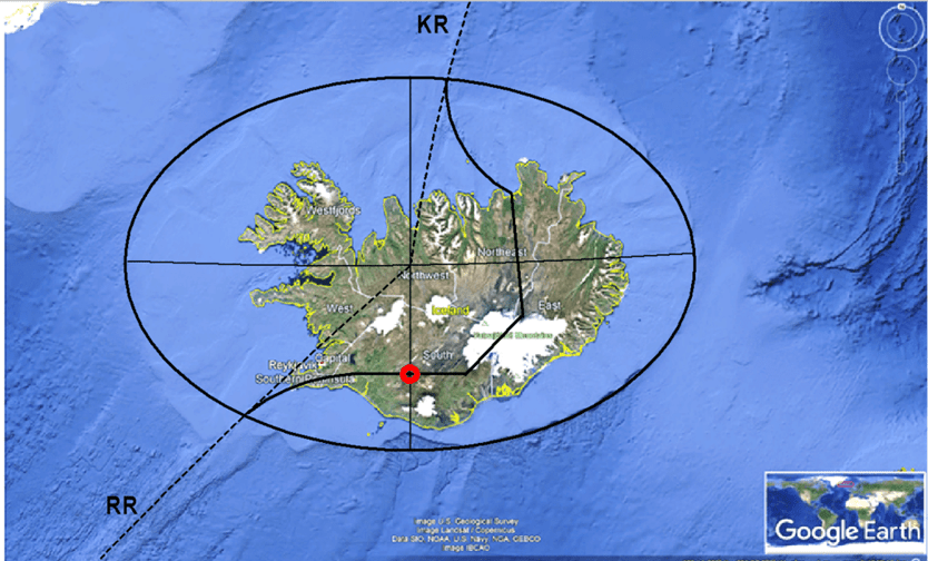
Most of these relationships can be examined directly from maps without invoking any particular model of mantle circulation. Nevertheless, the mantle-flow interpretation provides a possible explanation for the observed correspondences.
The geometry of Iceland therefore appears consistent with the broader geometry associated with the Antarctic Plate and the Ring of Fire.
Some may regard these observations as coincidence or as patterns not requiring further investigation. However, the number of apparent correspondences continues to increase. The geothermal field of El Tatio in South America and the geyser regions of Kamchatka both fit naturally into this framework. Together with Iceland, Yellowstone, and New Zealand, they encompass most of the major geyser regions of the world.
The Special Position of New Zealand and Its Surroundings
The position of New Zealand appears unique. South of the country, the minor axes of the Antarctic ellipse and the Ring of Fire ellipse connect through the mantle-flow boundary system. Nearby lies the volcano Mount Erebus, famous for its persistent lava lake.
More detailed examination continues to reveal additional relationships. Some aspects of the analysis may require revision or refinement in the future. Nevertheless, the degree of correspondence visible at first inspection is substantial enough to warrant serious consideration.
One reason these observations are difficult to dismiss is that they can be approached from two independent directions. On the one hand, simple map analysis and well-established knowledge of the Ring of Fire and oceanic ridges reveal a series of geometric correspondences. On the other hand, the same relationships appear consistent with the mantle-flow partition analysis, in which boundaries between mantle flow components have been identified and mapped.
Although only a broad overview is presented here, the underlying work extends considerably further. The uppermost mantle-flow components, typically spaced at intervals of 1.5° in longitude, have been mapped in detail, and their effects on the Earth’s surface can be examined with increasing precision.
This makes it possible to investigate local-scale relationships in New Zealand, Japan, and Iceland that are not readily apparent on generalized world maps. Even at this preliminary level, however, regions such as Hikurangi and Taupō appear to occupy key positions that may help explain their unusual geological activity.
A Closer Look at Taupō
Taupō can be interpreted both in terms of mantle-flow boundaries and its location near the minor axis of the Ring of Fire ellipse. Whether it also lies precisely on the inner boundary of the Ring of Fire is beyond the scope of the present discussion.
in context with convection rolls division lines.
The activity of the Alpine Fault along the length of New Zealand is almost certainly significant. At the opposite end of the Pacific lies the San Andreas Fault, which accommodates motion parallel to the Ring of Fire, whereas New Zealand accommodates motion across it.
Together, these two fault systems may play a major role in accommodating large-scale movements associated with both the Ring of Fire and the axis that extends from Yellowstone toward New Zealand and potentially onward into the corresponding minor axis of the Antarctic ellipse.
Subdividing the Ring of Fire
The Ring of Fire can be examined as a collection of distinct geological sectors. The geometric framework proposed here provides one possible means of organizing these regions.
The minor axis of the ellipse passes through New Zealand and aligns closely with the immense Tonga–Kermadec subduction system extending northeastward from the Hikurangi margin. This framework also corresponds surprisingly well with several major tectonic provinces:
- Aleutian Arc
- Queen Charlotte–Fairweather transform system
- Cascadia subduction zone
- San Andreas and the Californian transform province
- Central American subduction zone
- Peruvian subduction zone
- Chilean subduction zone
- Antarctic Peninsula
- Antarctic volcanic province
- Southern Ocean ridge system
- Eastern New Zealand margin
- Western New Zealand margin
- New Guinea–Tonga–Kermadec subduction system
- Philippines
- Taiwan–Japan sector
- Kuril–Kamchatka sector
Why this subdivision appears to work so well cannot yet be fully explained. The most prominent organizing elements appear to be the equator and the minor axis. Some of the apparent irregularities of the Ring of Fire fall within the region bounded by these two reference lines.
The major axis appears less important in this context, whereas the north–south central axis passes directly through Hawaii, as noted earlier.
New Zealand thus appears linked geometrically to Yellowstone and the San Andreas Fault on the opposite side of the Pacific, while being supported structurally by the Tonga–Kermadec subduction system. The correspondence between mantle-flow organization and the overall geometry of the Ring of Fire provides a basis for further investigation.
This interpretation emerged as a consequence of the mantle-flow component theory and the attempts to test it against observable geological structures.
Because the relationships described here can be examined independently on maps, they are open to further testing, criticism, and refinement. The most productive path forward is therefore to continue documenting the patterns, improving the underlying analysis, and allowing the evidence to be evaluated over time.
