Ophiolites are slices of oceanic crust that have been uplifted and exposed, making it possible to examine a cross-section of a tectonic plate. This provides a valuable opportunity to study the different layers of the Earth. There are many ophiolites, the most famous probably being those found in Oman and Cyprus. These were emplaced onto continental crust through obduction and are in some cases tilted or rotated.
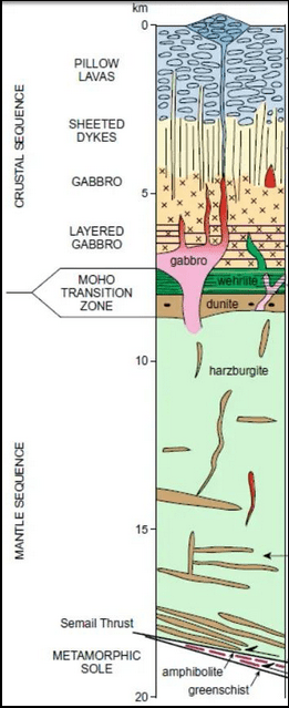
The uppermost ~5 kilometers of the brittle oceanic crust can thus be examined in cross-section. At the top lies a layer of pillow lavas, beneath which are sheeted dikes, followed by a gabbro layer extending down to the Moho discontinuity. In favorable cases, ophiolites also expose portions of the underlying mantle.
At the Moho, there is typically a transition zone composed mainly of two rock types: wehrlite just below the gabbro, followed by dunite. Beneath this lies the lithospheric mantle, which is composed mainly of harzburgite. This is a type of peridotite that remains after the original lherzolite of the asthenosphere has undergone partial melting to produce basalt.
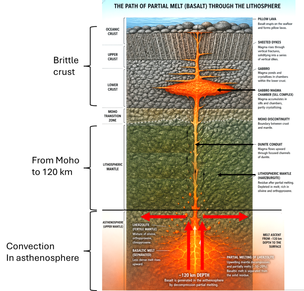
Basalt originates from the asthenosphere at depths of around 120 km. The temperature of basalt at eruption at the Earth’s surface is surprisingly close to the temperature at which it originally formed. In Iceland, basalt may represent up to about 20% partial melting of the original lherzolite.
One particularly important feature revealed by the exposure of mantle below the Moho is the presence of conduits through which partial melt (basaltic magma) has traveled. These conduits consist of dunite, composed almost entirely of olivine. They form vertical channels leading up toward the Moho. This indicates that partially molten material can flow upward relatively rapidly, entering the gabbroic section immediately above the Moho transition zone.
The gabbro zone is commonly divided into two parts, with the lower portion showing layered structures. Within this zone, basaltic magma can accumulate in sills and magma chambers, where it may partially crystallize before continuing its ascent. When conditions allow, the magma rises again, typically vertically, through the sheeted dike complex, forming successive dikes.
As frequently observed in Iceland, such processes can eventually lead to volcanic eruptions at the surface. On the ocean floor, these eruptions typically produce pillow lavas. The vertical continuity and rather fast flow of basalt up through the tectonic plate can explain how it maintains temperature (almost) found at the depth of 120 km at the surface. This AI picture expresses the process:
The vertical movement of partially melted material through the tectonic plates can partly explain why division lines in the asthenosphere can be detected at the surface. This process continues over long distances, forming dikes of considerable length. Even more importantly, this ongoing process creates divisions around which different parts, often described here as polygons, can adjust to the tectonic drift that constantly alters the positions of continents and oceanic crust. Another contributing factor is the local horizontal movement, combined with the global tectonic drift trend, which can lead to localized rifting or pressure at the surface.
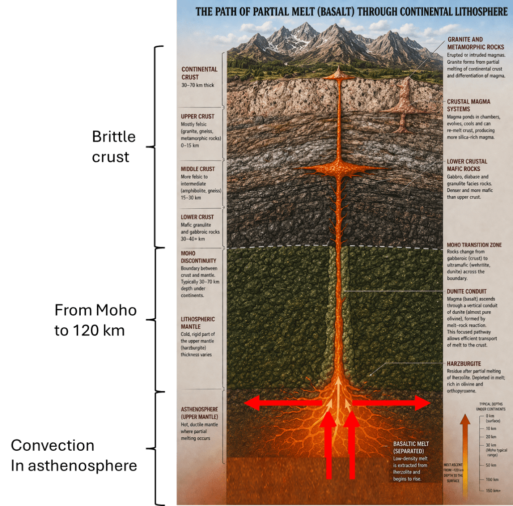
For mainland crust, the section looks slightly different for the upper most part. Again, this AI image can be made:
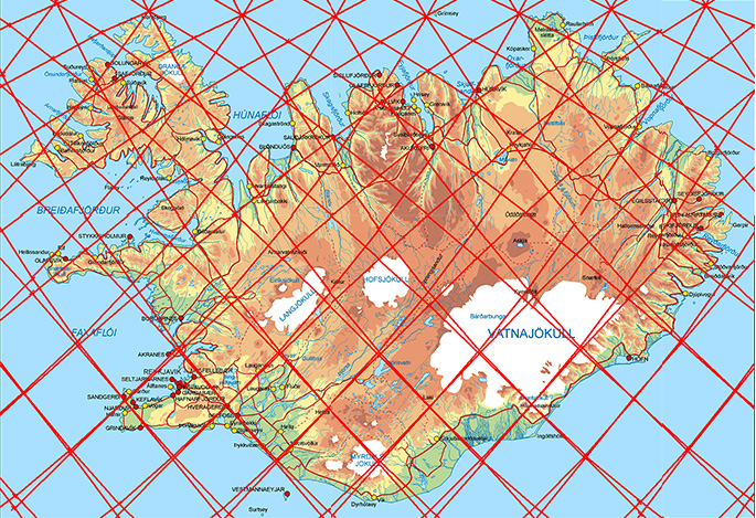
The result of this activity, which can be traced in mantle remains of ophiolites, can be detected on the surface. This is the map of Iceland: