Uncategorized

Reykjanes, West Volcanic Zone, Húsavík Fault, and Grímsey Oblique Rift as Surface Expressions of a Single Mantle Convection Roll

The convection roll bridging the gap between Reykjanes Ridge and Kolbeinsey Ridge

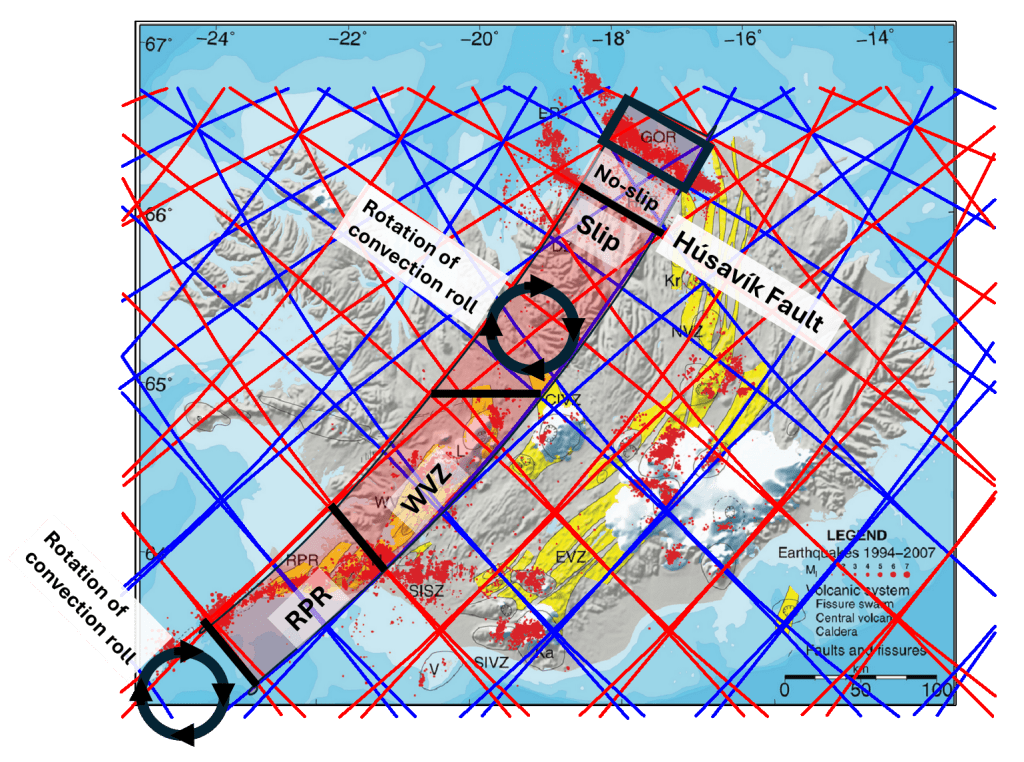
The West Volcanic Zone (WVZ) and the Húsavík–Flatey Fault (HFF) can be understood as two fundamentally different surface responses to the same mantle convection roll, whose flow direction is opposed to the absolute motion of the overlying plate. Where this roll is effectively coupled to the lithosphere, its opposition to plate motion promotes either extension or shear, depending on local boundary conditions.

Mantle Convection Roll at 120 km depth.

Map base: https://www.vedur.is/skjalftar-og-eldgos/frodleikur/greinar/nr/450

The WVZ represents the extensional response to this roll–plate opposition. South of approximately 65° N, the uppermost convection roll maintains sufficient mechanical coupling to the lithosphere to drive sustained rifting and volcanism. Northward of this latitude, however, the polygonal pattern of roll-division lines becomes increasingly complex, and the uppermost roll progressively loses its grip on the plate above. As a result, the rift architecture of the WVZ terminates, and extension is no longer the dominant mode of deformation.

These conditions prevail until the system reaches the HFF. At this location, the same convection roll appears to regain effective coupling to the lithosphere, but now in a geometrical setting defined by a lower division line of the asthenosphere. The result is not extension, but efficient dextral strike-slip motion, localized into a narrow, long-lived fault zone. The HFF thus represents a shear-dominated expression of the same roll–plate opposition that elsewhere produces rift volcanism (RPR, WVZ and GOR). The area south of HHF freely drifts with the North American Tectonic Plate (a smooth displacement of 60 km has been measured). North of the HHF, things are still a bit more complicated.

North of the HFF, a small number of polygons form a region with less seismic activity in which deformation is limited and distributed neither as rifting nor as focused volcanism. Farther north, beyond the next division line parallel to the HFF, the system enters the domain of the Grímsey Oblique Rift (GOR). This boundary lies east of the division associated with the Kolbeinsey Ridge (KR), and therefore clearly within the Eurasian Plate.

Within the GOR domain, the same convection roll continues to influence deformation, but in a setting where tension is created as the North Volcanic Zone (NVZ) fissure swarms extend to the east of the GOR. The GOR is therefore trapped between the Kolbeinsey Ridge and the northern most part of NVZ. This leads to the formation of a volcanic area, linking the NVZ with the Kolbeinsey Ridge. Here, shear and extension are combined, and as a consequence, both seismic activity and volcanism become widespread. Volcanic systems within the GOR represent the volcanic manifestation of this distributed deformation, while seismicity reflects ongoing strain accommodation across the polygonal framework.

Uncategorized

The circular tectonic drift vectors of Anatolia

The tectonic drift of the Anatolian Plate is notably independent from its surroundings. While the Arabian Plate moves northward, similar to the African Plate, the Anatolian Plate exhibits a counterclockwise rotation. This motion can be examined through the lens of the convection rolls model to see whether it offers any additional insights. The outcome is striking and reveals two key points:

  1. The combined structure of convection rolls and plate boundaries appears to create the conditions for a central pivot point around which the Anatolian Plate rotates.
  2. If a fixed point within the convection model exerts a dominant influence on tectonic drift, then the convection rolls also offer a framework for understanding the subduction of the African Plate beneath the Eurasian Plate.

The map showing drift vectors can be found at:
https://www.tandfonline.com/doi/full/10.1080/19475705.2024.2446588#abstract

The most significant observation is that this central pivot lies near the 32nd parallel, precisely where two mantle upwelling lines intersect at approximately 32.1°E. Along this latitude, the convection roll system is aligned exactly north–south, making it a key structural feature, comparable in importance to the equator and the 64°N/S parallels. Interestingly, this location corresponds roughly to the eastern edge of the Nile River delta. It has previously been noted that the deltas of the world’s largest rivers—especially the Amazon at the equator—are situated at critical junctions within the convection rolls framework. https://magicmagma.com/2022/10/04/what-do-the-three-famous-rivers-amazon-nile-and-mississippi-have-in-common/

Given this fixed relationship between surface tectonics and mantle convection geometry, the concept of rollback requires reconsideration. In this case, the European continent appears to be drifting away from the latitude at which the African Plate subducts beneath it. Whether we interpret this as northward retreat of the African slab or northeastward drift of Europe, the geological consequences are functionally the same.

The side-view depiction of African Plate subduction shows how numerous geological features have developed over the last 35 million years, since subduction began. These reflect the continuing northeastward movement of the Eurasian Plate, while the northern edge of the African Plate descends beneath it.

This is from https://www.youtube.com/watch?v=cqK-CbuM3Eo

Just to clarify a bit what drives the tectonic drift anomaly of Anatolia, a particular bit of convection roll can be pointed out:

It can also be pointed out that most geothermal activity is found in this part of Turkey. Take a look at this map:

It is from https://www.researchgate.net/figure/Geothermal-map-of-Turkey-MTA-2021b_fig1_365230456

The red area in Western Turkey coincides with the convection roll taking part in driving the rotation of the local tectonic plate. This can explain the geothermal activity anomaly.

Note that the appearence of the aggregate of vectors of GPS drift measurements of the Anatolian Peninsula is not only circular, but also basicly from east to west. The mathematical precision of the drift can only be possible because of a very regular system of convection rolls underneath. The rolls following the drift are coupled to the layers above, the ones opposing are decoupled. Thereby the engine driving this interesting rotational drift of the plate can be explained thoroughly.

Just to clarify further how the convection rolls move the tectonic plate, this drawing is added:

The red areas provide force for the circle to move anti-clockwise in an almost circular way. As previously mentioned, the pivotal point is also a key point within the convection rolls system as a whole, due to the exact N-S alignment of convection rolls at the 32nd latitude.