The volcanic activity near Grindavík can be explained by referring to the interaction between a dyke forming within the volcanic zone, and magma from the dyke finding its way to the surface through earthquake faults. A seismic zone creats a weakness of the crust within the area. The orientation of the dyke is quite different from that of the earthquake faults. According to calculations the dyke is oriented about N43°E, and the earthquake faults trend is directly N-S. Real circumstances are not quite so simple, because the upper most manifestations of earthquake faults are en échelon arranged, divided into smaller systems with NE-SW trend. The dyke, when meeting with the earthquake faults, also bends, or follows the N-S trend near the eruption site. As I have been exploring the possibility that convection rolls are found withn the asthenosphere, and mapping the division lines between them, it is interesting to compare those lines with the conditions at the eruption site. Two downwelling lines of the lower parts of the asthenosphere are found directly below the eruption site itself. To understand the situation better, we should have a look at a map showing this:
This shows how the black division line crosses the Reykjanes Seismic Zone shown with red parallel lines. It is tempting to assume that the origin of magma can be traced to those two division lines directly below the eruption site. Another possibility is that the magma is originated from the upper most division line, alinged NE-SW, found slightly west of the eruption site, flowing at first under the crust along the NW-SE aligned line until it reaches the eruption site area. Then it ascends into magma chambers and finally to the surface.
This site shows many different situations where convection rolls system and real circumstances fit together. This is of course a very good example. The fact that the three eruptions along the dyke which formed under Fagradalsfjall, and the four eruption that have already taken place along the dyke forming at the side of Sundshnúkur have the same petrological origin is consistent with this.
This is an explanation built on many years of research. I have taken part in a series of conferences and meetings, publishing papers where the scientific papers pointing in this direction are cited. I also took part in mapping the South Iceland Seismic Zone, giving me the feeling of how the seismic area of Reykjanes works, as those two systems are connected end-to-end.
To explain the heat flow within the Earth, from radioactivity to eruption, is not easy, but it can be done. This eruption deserves much attention, and among the countless examples shown here, this one of those literally to the point.
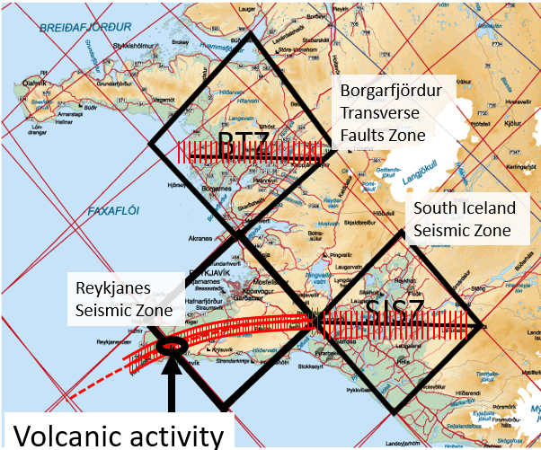
The two other seismic zones of West Iceland (BTZ) and South Iceland (SISZ) are added to show how likely it is that the polygons surrounding distinct areas of Iceland really exist. To form a seismic area, pressure is nedded. The faults are all N-S oriented, so regularity is needed. The parallel faults are found side by side in E-W direction, having distinct endpoints, so the area is limited. The only solution for an outer framework is a polygon, exactly as drawn on the map here above. The division lines between convection rolls coincide with this enevitable polygonal shape surrounding the seismic zones. Therefore, it makes sense that the division lines are responsible for shaping the polygons in the first place. It is all about logic.
