Uncategorized

Japan and the location of Fuji

black and white mountain over yellow white and blue sky
Photo by Pixabay on Pexels.com

Mount Fuji is located on a triple junction between three plates. It should explain it all, besides the vicinity to the Pacific Plate descending into the mantle. But compared to the convection cell model, the position is unique. Fuji is located directly on one of the division lines of the lower mantle as shown here:

Lines - Iceland - Japan

Now we zoom in on Japan to show more details. It is interesting that the convection cells are aligned directly NS at 32°N, and Japan is just north of that parallel, so here is an example of how it works:
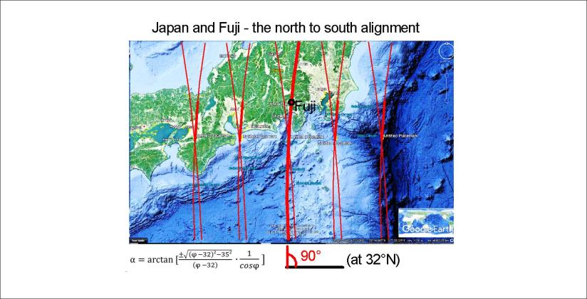
Japan - Fuji - 01

This line is a counterpart of the main division line under Iceland:
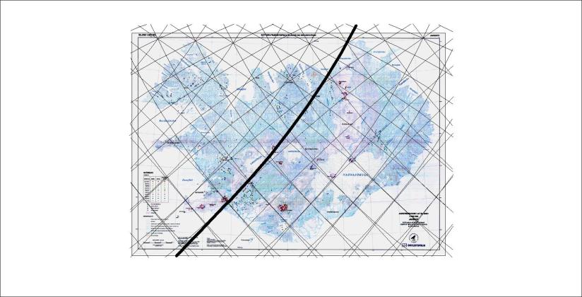
Iceland division line

As has been pointed out in other posts, this line represents both the main convection division at 410 km depth, and the upper most division line of small cells at 120 km depth. The smaller cells are down-welling, and the two lines to each side of course up-welling.

Therefore, in Iceland, The Reykjanes Ridge is found west of this line, whereas Hekla is east of it. Still, many volcanic and geothermal sites are also on the main division line, with the controversy of having up-welling deep below, but down-welling in the upper layer.

This is of course in a way complicated, but it is easy to see what Japan and Iceland have in common according to this model of the convection rolls within Earth’s mantle.


Uncategorized

Indonesia and Philippines – chaos or regularity?

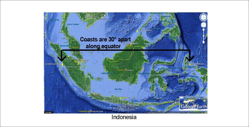
Indonesia does extend exactly 30° along equator, just as everyone can see on a map (approximately from 99°E to 129°E). It fits to the analysis that underneath there is a convection roll in the lower mantle, exactly 30° wide. This is the big mystery of the equator line!

Indonesia 30 at 0

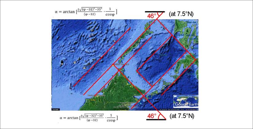
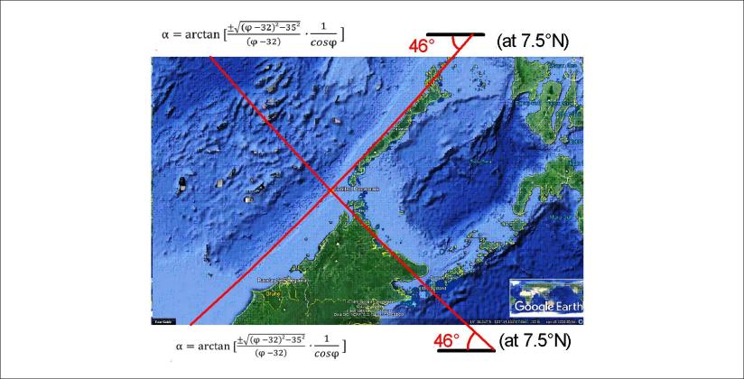
Looking at the details of Indonesia, some interesting forms show up. Two of the convection division lines look like this:

Palawan and Borneo - lines

With these calculated lines put into place, let us look at how nature has shaped the tectonics around:

Palawan and Borneo - squares

This is a place of symmetry, and square forms! A more detailed analysis can tell us much more.

Uncategorized

Juan de Fuca – following the main trend

The Pacific Ocean shows the same features as the Atlantic Ocean. A good example is Juan de Fuca, following the direction of division lines extending from equator, according to the same formula as the Reykjanes Ridge, Kamchatka and countless other distinct linear topographic phenomena. Here is the simplified drawing on a Google map base:

Juan de Fuca - 01

The number of features following the trend of the calculated alignment of convection rolls is just about endless. The secondary calculations then count for a wide range of tectonics otherwise difficult to explain. You might ask: “What are the secondary calculations?” The answer can be simple: “An example of secondary calculation is half the angle of the formula shown here. That is about W37°N or W37°S. Are there any features following that trend?”

Uncategorized

Kamchatka shows the curvature of mantle convection rolls – as the subduction counterpart of the Reykjanes Ridge!

Geology of calculations! The line of volcanoes in Kamtchatka follows the same formula as the volcanic zones in Iceland! It is exactly parallel to the Reykjanes Ridge.

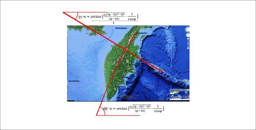
The topography of Kamchatka has a very decisive linear form, and of course the volcanism there is well known. The reason for the volcanic activity is in a way opposite to that in Iceland, so it is interesting that the same formula can be applied to get exactly the correct direction following the chain of mountains, the division between mountains and lowlands etc. Here, it is shown how the curvature along the peninsula fits to the swaying form of the convection rolls underneath.

Kamchatka Peninsula - 01

The inserted lines are calculated according to φ = 57° for hemispheric convection cells. The result is N28.6°E, shown with the slightly curved line for the drawing, which fits perfectly to the peninsula. The adjacent Alpha Fracture Zone is perpendicular to the Kuril-Kamchatka Trench and thereby to the tectonic framework and topographical trend of the peninsula. The angle is close to being half the calculated value for the latitude, as shown by a line extending from the continent out to the trench, oriented N58.2°W. The half angle value is added because it repeatedly found under similar circumstances, for Hekla, California, Hawaii, etc.