Uncategorized

Katla – the invisible volcano

Katla is a mystery, because no one has seen the volcano. Now we can detect it easily with modern technology through the ice sheet of Mýrdalsjökull, but somehow it remains obscure.

The division lines between convection rolls crossing below the mountain are marked on the map below. The black line is a downwelling line of the upper most layer, and the red line is upwelling line of the second layer.

Katla 01

Many of the most famous active areas in Iceland are found along these lines. That is in accordance with the activity of Katla – surprising everyone each time it erupts.

Uncategorized

Drangey, the overlooked volcanic island of Iceland

It is known that Drangey is less than 700,000 years old, because its rocks did form within our period of geomagnetic reversal. The volcanic zone of Drangey did appear at the same time as the Snæfellsnes volcanic zone, but now it is extinct. However, geologically  speaking Drangey and the volcanic zone are rather young formations and can be compared with contemporary active areas. Then we get this picture:

Drangey 01

Note that the dotted lines from the central line (showing the deep mantle division) have exactly the same length. Therefore, the distance from the crater of Eyjafjallajökull to the centre, and from the center to Drangey, are exactly the same, besides being accurately on the same NS-axis. The same applies for Snæfell and Snæfellsjökull along the latitude of 64°48′N . From the same central point, the distance is exactly the same form Snæfell to the said central point as the distance from the center to Snæfellsjökull.

This type of consistency is impossible to achieve, unless reality is involved.

Drangey 02

This is an island of stories and wonders. Please check it out.


Uncategorized

Can we make use of our knowledge about Earth’s layers to anticipate the Moon’s structure?

Is it possible to use what we know about Earth to find out more about the Earth’s Moon? At least we can extrapolate the proportions of Earth’s layers and see whether that fits for the Moon. It looks like this:

Tunglið 03

This is a guess, but it fits very well, and is in coherence with the convection cell theory.

What is new in this is claiming that the inner core has the radius of about 123 km. The other layers have been measured according to Apollo seismic data.

Extrapolating in this simple way is of course a bold method, but what we begin with is this picture of the Earth:

Earth askew - equator

As long as direct measurements are not violated, this can be seen as a valid contribution to the discussion. As far as I know, the diameter of the Moon has not been measured directly yet. Inge Lehmann found the inner core of the Earth in 1936.

Uncategorized

Earthquakes on Reykjanes Ridge – perpendicular to the ridge itself?

Earthquakes can tell a story. The The Icelandic Met Office provides information about earthquakes in and around Iceland. The earthquakes which occurred yesterday (15th of July 2018) on the Reykjanes Ridge make up a row perpendicular to the ridge itself.

Skjálftar á Reykjanesi 15-7-2018

I added a line showing the calculated angle of the lower convection cell layer. this type of alignment often occurs, more and less unnoticed.

Just for comparison, the convection cell grid is shown here on a map from the Icelandic Met Office to see how it works.

Skjálftakort með grind - Reykjanes      
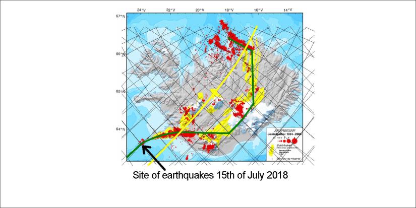
This is the site of an intersection point between polygons, where the Reykjanes Ridge makes a slight turn towards the Reykjanes Peninsula. South of this point, the Reykjanes Ridge follows the convection cell line.


Uncategorized

Siberia – the other border between Eurasian Plate and N-American Plate

In Iceland divergent boundaries between plates can be watched directly. Plates also meet in Siberia, but in much more obscure way. Map showing the exact location is hard to find. There should be similar logic everywhere for boundaries between tectonic plates, so let us check Siberia:

Siberia - division - theoretic

The so called MORVEL model shows most plates location, so please compare it to what is shown here. The exact comparison can then be made in a similar way as for Iceland where every detail of how the plates are deviding from each other can be traced accurately with the mantle convection cell model.