Uncategorized

Equator and The Great Rift Valley

The arrangement of sea and landmass along equator is regular as shown here:
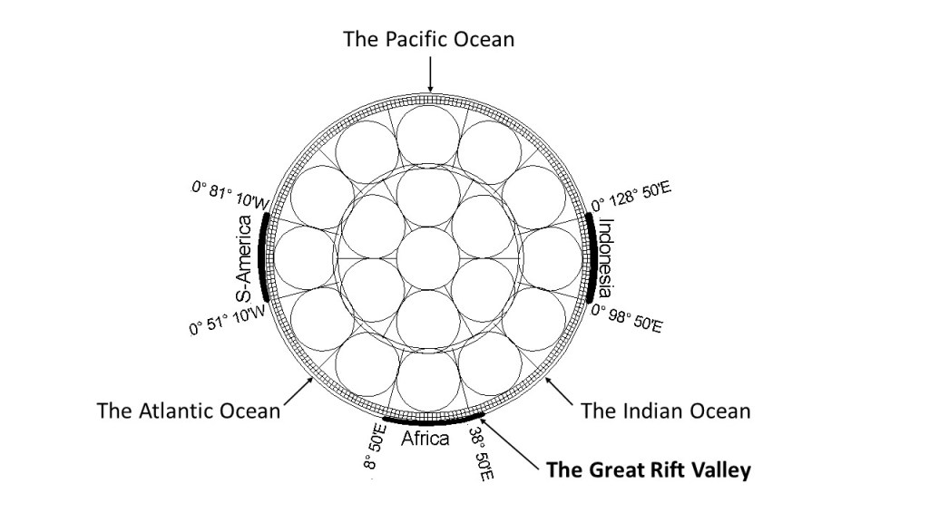
Section view of equator – land mass shown with thick lines. Distribution is not random. 1) S-America, Africa and Indonesia form 90° angles. 2) Land covers 30° sections of equator. 3) The ridges of the Atlantic and Indian Oceans are found at 30° distance from coast at each side.

The pattern along equaor of 30° span of S-America, 60° span of Atlantic Ocean, 30° of Africa from west coast to Great Rift Valley, 60° from Great Rift Valley to Indonesia, 30° from west coast of Indonesia to east coast of Indonesia, is quite obvious. Moreover, the pattern fits with the arrrangement of convection rolls within the mantle, considering that mantle material convects in rolls of equal hight and width under balanced conditions of flow.

The proof is found with the location of the Great Rift Valley, as it is not found in context with coast-to-coast distance, but from the west coast of Africa over to a geological phenomena within the continent, that is clearly there due to the inner forces of Earth.

To further examine the distribution of geological features, one can ‘zoom in’ on the Great Rift Valley, and see how it does comply in detail with the upper most convection rolls, close to the tectonic plate.
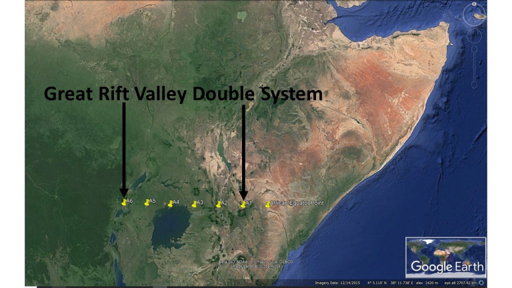
The double system of Great Rift Valley.

Uncategorized

The Double Nature of the African Great Rift Valley

At equator, the Great Rift Valley is divided into two main parts, described in Wikipedia: https://en.wikipedia.org/wiki/Great_Rift_Valley. The western rift, called Albertine Rift and the eastern rift, called Gregory Rift, together span 9° from east to west along equator. The convection rolls responsible for the formations are shown here:

The convection rolls beneath the two sections of Great Rift Valley.

Each convection roll spans 1.5° from east to west, making the effects on the surface quite understandable. The rifting process is therefore subject to three upwelling sites, whereas the outer margins are marked by downwelling division lines between mantle convection rolls.

Note: A tectonic plate is 120 km thick structure, with a brittle upper part and ductile lower part. The transformation from the rigid structure of tectonic plate, to the flowing nature of mantle material takes place 120 km below the surface. Therefore, adiabatic temperature gradient is found below 120 km depth (described in: Volcanoes: A Planetary Perspective: Written by Peter Francis, 1993 Edition, Publisher: Clarendon).

Uncategorized

The Aegir Ridge Compared with Geological Features of Iceland

The Aegir Ridge is a huge geological feature, in between Iceland and Norway. The Wikipedia descirption of it is here: https://en.wikipedia.org/wiki/Aegir_Ridge. It was responsible for the opening of the Atlantic Ocean at the relevant latitudes, but is now extinct and drifts along with the Eurasian Tectonic Plate.

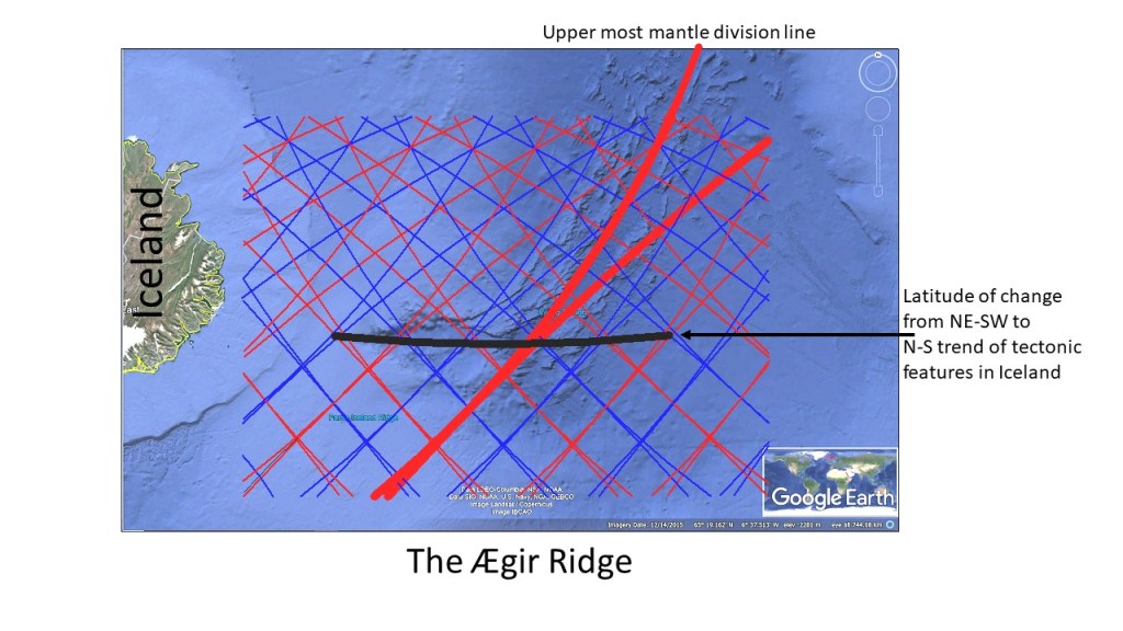
All the same, the Aegir Ridge shows resemblence with the tectonic arrangement of Iceland. Moreover, it is all in accordance with the convection rolls system, as shown here:

Aegir Ridge with Convection Rolls Division Lines.

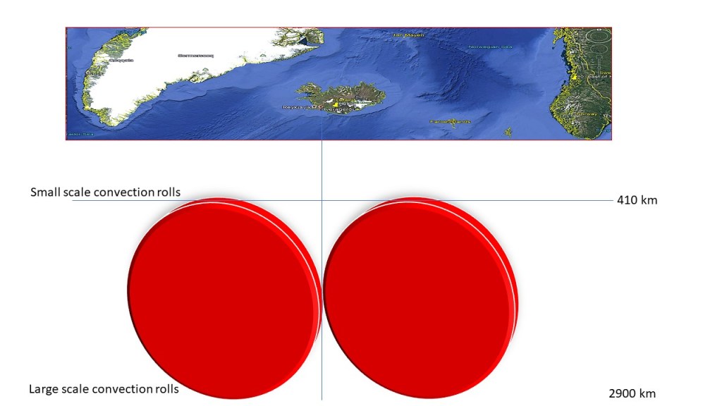
The Aegir Ridge, as seen on this Google Map, is aligned E-W at the latitude of 64°50′, where the main tectonic features of Iceland make a turn from NE-SW (south of the line) to N-S (north of the line). The northern part of Aegir Ridge follows the same alignment as the upper most convection rolls of 120 km depth. The central line is the tenth convection roll division line counted from the Reykjanes Ridge convection rolls division line. That is half the span of the large convecton roll extending from Iceland to Norway, as each large scale roll spans 30° from east to west. Small scale rolls span 1.5° from east to west.

Uncategorized

Sections of Large Scale Convection Rolls below the Atlantic Ocean

The convection rolls under the tectonic plates can be represented with short sections. The most obvious example is found under the Atlantic Ocean.

Simplified Drawing of Short Sections of Convection Rolls.

These large scale convection rolls span 30` along each latitude, as shown below.

Outer Limits of Convection Rolls Sections Marked with Red.

These drawings can then be used for a first step learning to be able to understand the Convection Rolls System. The convection rolls shaping the Atlantic Ocean were in fact first noticed a long time ago, but attention was mainly directed towards surface features. Alfred Wegener noticed that the continents fit together, and was clear-headed enough to see that it could be no coincidence. Then he systematically studied each side of the Atlantic, and other parts of the world, to find the global picture of tectonic drift. In the same way, we can make use of the clarity of structure of the Atlantic Ocean to understand the forces responsible for tectonic drift, volcanic activity and formation of geothermal areas.

Uncategorized

An Example of Epicenters Alignment of Tjörnes Fracture Zone

The Tjörnes Fracture Zone combines the North Volcanic Zone with the Kolbeinsey Ridge. The alignment of epicenters follows the mathematical model of convection rolls closely. Today, the ‘Met Office’ map looked like that:

Epicenters of TFZ 17-8-2020

Comparing with the convection rolls model shows how the SE-NW alignment follows the division line, whereas the N-S aligment does trace the central axis of the polygon marking the very beginning of Kolbeinsey Ridge.

Seismic activity of TFZ 17-8-2020

Besides that, Grímsey is pointed out. Grímsey Island is the northern most inhabited part of Iceland. It is found close to a ‘hub’ of division lines of different layers, leading to an anomaly of volcanic and geothermal activity within the surrounding area.