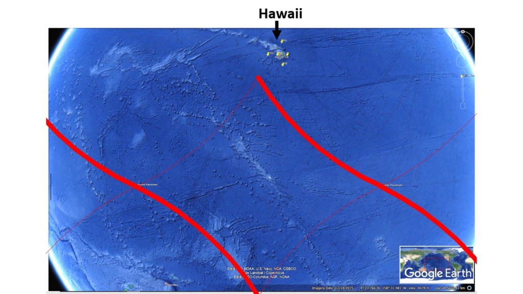
After exploring three sides of the Earth, more and less alike, the fourth side looks totally different. The Central Pacific Ocean provides very few clues about what is found underneath, with the main exception of Hawaii.
Center of the Pacific Ocean.
If there was a continent there, like Africa, South America or Indonesia, we would have analyzed that consistency a long time ago. This one exception leads to the fact that we do not seem to consider the consistency between the three equatorial continents at all! But considering that Hawaii exist due to the proximity with main division line between convection rolls, the picture becomes clearer. Hawaii itself is offset from the main lower mantle convection rolls division line by 3°, but the chain of islands then drifts obliquely over it.
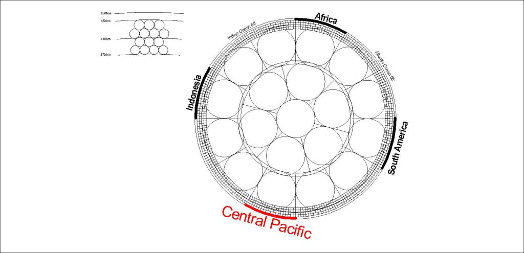
We can then have a quick look at the ´four side pattern´:
The four sides of the equatorial plane of Earth.
So if we have an imaginary place in the middle of the Pacific, where we might expect to find a continent, do we then start to think differently about it?
The similarity between Central Africa, Amazon and Indonesia is quite striking. The three areas are found at equator, span 30°, and are found with 60° interval. Also, volcanic and tectonic activity is found in context with the relevant mantle convection division lines, marking the large scale polygon.
The African Polygon
The volcanic activity in eastern Africa is related to the Great Rift Valley, which is closely related to the tectonics formed by the east corner of the polygon of Central Africa.
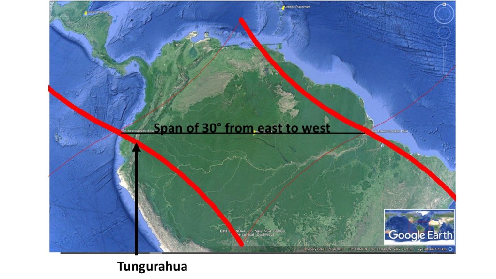
The Amazon area is mostly found within a large polygon marked by the division lines of each side of a single convection roll of lower mantle. The main hub of downwelling forms the esturary of the Amazon River, the largest river in the world. At the other side of the continent, the division line (wide red) between convection rolls does cross the Andes Mountains under the volcano Tuguruahua.
The polygon of Amazon area
The exact 30° span along equator from the trench in the east to the estuary in the west is an outstanding manifestation of the predicted interval between convection rolls of the lower mantle.
Indonesia covers 30° along equator from east to west, and the end points happen to be the locations of main convection rolls division lines. Tracing the western division line further south, it leads to the most active volcano of Indonesia, Mount Merapi.
Mount Merapi is located over main division line of lower mantle convection rolls.
This indicates an interplay between the subduction of crust material and the mantle convection activity. The few facts shown on the map, a span of 30° along equator and the location of Merapi, already give us some insight into the geology of Indonesia. By further analyzing the effect of upper convection rolls (with 1.5° interval) much more will be revealed about the real nature of volcanism, geothermal activity and the tectonic framework in general.
The Icelandic Plateau is elliptical and can be drawn accurately with a definite central point. Expanding the ellipse towards the Jan Mayen Fracture Zones, it overlaps them. Expanding further, an ellipse with same NS-axis meets with the West Coast of both Norway and Greenland. The same structure shows consistency with Greenland-Iceland Ridge and Iceland Faroe Ridge. To describe the details accurately would take many pages, but everyone can have a short look at this map, saying as much as thousand words:
Large Scals Symmetry between Norway and Greenland.
Of course this is no coincidence, because of the large scale convection rolls found underneath the North Atlantic Ocean. The main division line between those convection rolls is found near, and parallel to, the central axis of the Reykjanes Ridge. The fact that Ægir Ridge became inactive, leaving a slice of East Greenland where Jan Mayen is found today, did lead to the special result that the West Coast of Norway and West Coast of Greenland match within this framework. The symmetry found along certain latitudes is due to the effect of Earth’s rotation, and the correspondatly regular formation of mantle convection rolls.
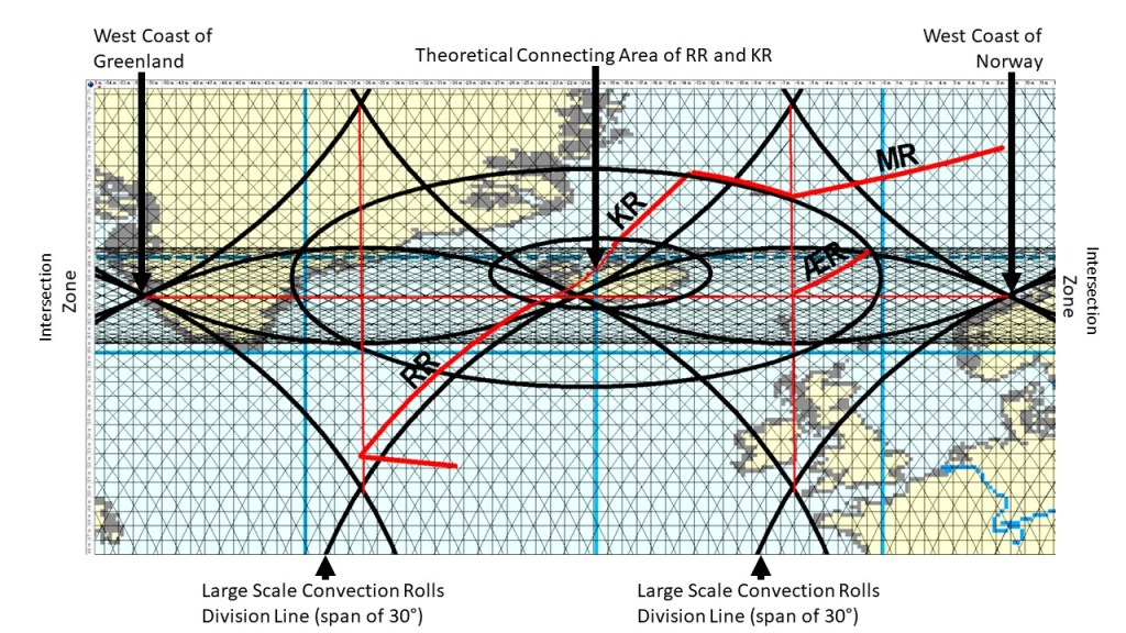
As some aspects can be seen clearer in context with the convection rolls model, another map is added hear with similar information:
Symmetry compared with mantle convection rolls system
Along 64°N, the most obvious symmetry is the 60° interval between West Greenland and West Norway, with central point exactly where the two convection rolls division line passes through Iceland. The other central focus of Iceland is where the two ridges would meet if they were continued on the surface. That is the central point of the Large Icelandic Plateau, and also the central point for an elliptical form that fits with Jan Mayen Fracture Zone, and thereby the end point of the Kolbeinsey Ridge (KR). It also marks the end of the Ægir Ridge. Large scale polygons seem to be affecting the locations of termination of all the ridges.