The Icelandic Plateau is elliptical and can be drawn accurately with a definite central point. Expanding the ellipse towards the Jan Mayen Fracture Zones, it overlaps them. Expanding further, an ellipse with same NS-axis meets with the West Coast of both Norway and Greenland. The same structure shows consistency with Greenland-Iceland Ridge and Iceland Faroe Ridge. To describe the details accurately would take many pages, but everyone can have a short look at this map, saying as much as thousand words:

Of course this is no coincidence, because of the large scale convection rolls found underneath the North Atlantic Ocean. The main division line between those convection rolls is found near, and parallel to, the central axis of the Reykjanes Ridge. The fact that Ægir Ridge became inactive, leaving a slice of East Greenland where Jan Mayen is found today, did lead to the special result that the West Coast of Norway and West Coast of Greenland match within this framework. The symmetry found along certain latitudes is due to the effect of Earth’s rotation, and the correspondatly regular formation of mantle convection rolls.
As some aspects can be seen clearer in context with the convection rolls model, another map is added hear with similar information:
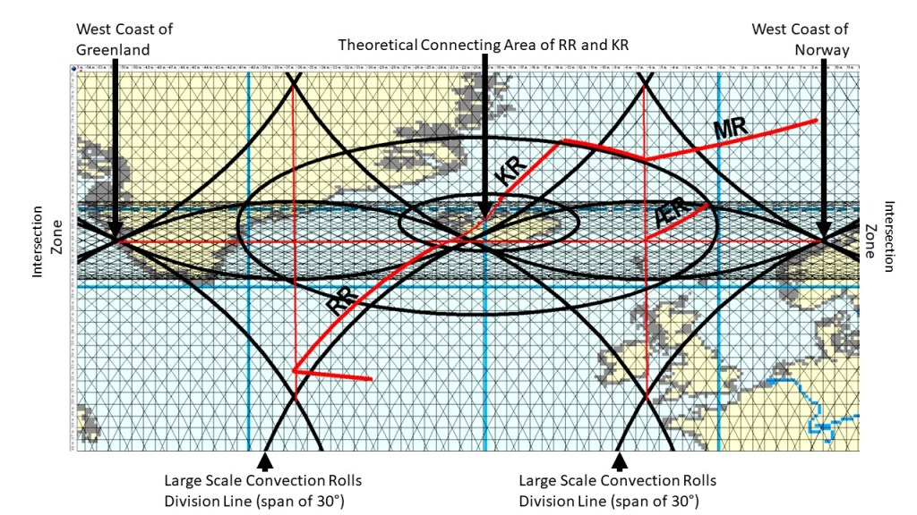
Along 64°N, the most obvious symmetry is the 60° interval between West Greenland and West Norway, with central point exactly where the two convection rolls division line passes through Iceland. The other central focus of Iceland is where the two ridges would meet if they were continued on the surface. That is the central point of the Large Icelandic Plateau, and also the central point for an elliptical form that fits with Jan Mayen Fracture Zone, and thereby the end point of the Kolbeinsey Ridge (KR). It also marks the end of the Ægir Ridge. Large scale polygons seem to be affecting the locations of termination of all the ridges.
